
Oldendorf (district of Stade)
| coat of arms | Germany map | |
|---|---|---|

|
Coordinates: 53 ° 36 ' N , 9 ° 15' E |
|
| Basic data | ||
| State : | Lower Saxony | |
| County : | Stade | |
| Joint municipality : | Oldendorf-Himmelpforten | |
| Height : | 12 m above sea level NHN | |
| Area : | 23.88 km 2 | |
| Residents: | 3017 (Dec. 31, 2019) | |
| Population density : | 126 inhabitants per km 2 | |
| Postal code : | 21726 | |
| Area code : | 04144 | |
| License plate : | HOURS | |
| Community key : | 03 3 59 036 | |
| Address of the municipal administration: |
Schützenstrasse 5 21726 Oldendorf |
|
| Website : | ||
| Mayor : | Johann Schlichtmann (community of voters) | |
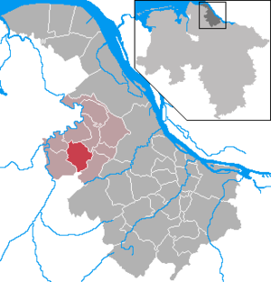
| Location of the municipality of Oldendorf in the district of Stade | ||
  |
||

Oldendorf ( Low German Olendörp ) is a municipality in the district Stade in Lower Saxony and a member of oldendorf-himmelpforten . In addition to the main town of the same name, the localities of Kaken, Timmerlade, Sunde , Weißenmoor and the Oldendorf settlement also belong to the municipality.
history
The name Oldendorfs comes from Low German and means old village .
In August 1959 a large moor and heather fire raged in the Hohe Moor near the Oldendorfer See, which could only be extinguished after four weeks.
In autumn 2009, skeletons from 54 graves were recovered in the area of the old cemetery. The conditions for preserving the bones were extremely poor. From the long occupation time of the cemetery only the burials of the top grave class from the 18th and 19th centuries have survived. Century and the skeletons of the medieval graves dug into the existing ground from the 10th / 11th. Century preserved. The results were evaluated separately according to the time horizon. A representative section of the population was found for the early modern period, but only a random part of the population for the Middle Ages. The highest death rates in the early modern period were in infancy and among adults. Child mortality was extremely high at 50%. Caries defects were found on the teeth of 77% of all adult individuals , with clear differences between the epochs. In the early modern period, the overall caries burden was considerably higher, which suggests a higher-carbohydrate, plant-based diet. Three children were likely to have chronic vitamin C deficiency . The high exposure to diseases of the upper respiratory tract of those buried in the early modern period was striking. At least every second person had chronic nasal infections and maxillary sinus infections. This agrees with historical records that report heavy smoke development in the residential buildings from the open stoves. Signs of the rare Hand-Schüller-Christian disease were found on the skull of a woman of advanced age .
politics
Municipal council
The municipal council, which was elected on September 11, 2016, is composed as follows:
- CDU 4 seats
- Flat share Oldendorf 7 seats
- Citizens for Environment and Social Affairs 2 seats
(Status: local election on September 11, 2016 )
badges and flags
The coat of arms was approved by the local council on September 27, 1982 and approved by the Stade district on December 30, 1982.
Blazon : “Split and split behind; in front in green a continuous golden cross, in back above in gold a black left-looking eagle with red reinforcement, in the back below in black a golden, growing left-facing lion with red reinforcement. "
The cross stands for St. Martin's Church, which as an imperial parish and baptistery church gave the parish of Oldendorf a central role as early as the 11th century and still gives it today. The green symbolizes the predominant agricultural structure of the community. The eagle and the lion are borrowed from the coat of arms of Daniel von Arentsschild, who was ennobled and ennobled by the kings Christian of Sweden in 1651 and Karl X. Gustav of Sweden in 1653, who had his ancestral seat in Oldendorf since 1642 and after his death in 1670 was buried in the church of St. Martin zu Oldendorf.
The flag of the municipality is yellow - green striped with the municipality's coat of arms.
Culture and sights
Buildings
Oldendorf has an 800-year-old stone church, the Sankt-Martinskirche, whose steeple is 36 m high.
Economy and Infrastructure
traffic
Via the L 114, Oldendorf has a connection to the B 73 in Himmelpforten , which leads to Stade and Hamburg , and to the B 74 in Elm , which continues to Bremervörde . In the long term, the construction of the federal motorway 22 past Oldendorf is planned.
Public facilities
A branch of the joint municipality administration is located in Oldendorf.
education
The Oldendorf school center includes elementary , secondary and secondary schools as well as a kindergarten . The Rudolf-Pöpke-Sportzentrum, which is right next to the school, is used by the school and by TuS Oldendorf.
Individual evidence
- ↑ State Office for Statistics Lower Saxony, LSN-Online regional database, Table 12411: Update of the population, as of December 31, 2019 ( help ).
- ^ Project Oldendorf. In: anthropologie-jungklaus.de. Retrieved June 4, 2017 .
- ↑ Coat of arms of the municipality of Oldendorf ( Memento from June 19, 2012 in the Internet Archive )
Web links
- The "old" Oldendorf in text and pictures
- The church of St. Martin zu Oldendorf - a jewel of architecture in the Eastern region
Agathenburg | Ahlerstedt | Apenses | Balje | Bargstedt | Beckdorf | Bliedersdorf | Brest | Burweg | Buxtehude | Yours | Dollern | Drochtersen | Düdenbüttel | Engelschoff | Estorf | Fredenbeck | Freiburg / Elbe | Grossenwörden | Grünendeich | Guderhandviertel | Hammah | Harsefeld | Heinbockel | Himmelpforten | Hollern-Twielenfleth | Horneburg | Jork | Kranenburg | Crooked dike | Kutenholz | Mittelkirchen | Neuenkirchen | Nottensdorf | Oederquart | Oldendorf | Sauensiek | Stade | Stone churches | Wischhafen