Elm (Bremervörde)
|
Elm
City of Bremervörde
|
|
|---|---|
| Coordinates: 53 ° 31 ′ 8 ″ N , 9 ° 12 ′ 21 ″ E | |
| Height : | 6 m above sea level NHN |
| Area : | 24.87 km² |
| Residents : | 1470 (Jan 31, 2015) |
| Population density : | 59 inhabitants / km² |
| Incorporation : | March 1, 1974 |
| Postal code : | 27432 |
| Area code : | 04761 |
|
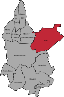
Location of Elm in Bremervörde
|
|
|
Map of Elm with the watercourses and traffic routes
|
|
Elm ( Low German Öölm ) is a district of the city of Bremervörde in the Rotenburg (Wümme) district in Lower Saxony and, after the actual urban area itself, the largest district in terms of area.
Description of coat of arms
| Blazon : "In Gold over blue wave beams a green three-bladed elm branch." | |
location
Elm is located on the federal highway 74 between Bremervörde and Stade , about 6 km northeast of Bremervörde city center. At the northern edge of the district, the state road 114 meets the B 74. In the west, Elm is bordered by the Oste , in the north it borders directly on the district of Stade .
history
The former municipality of Elm belonged to the office of Himmelpforten in Landdrostei Stade during the time of the Kingdom of Hanover .
After the annexation in 1867 by Prussia , the district of Bremervörde was formed on April 1, 1885 in accordance with the district regulations for the province of Hanover from 1884 from the municipality of Elm, the Bremervörde office and the city of Bremervörde .
On March 1, 1974, Elm was incorporated into the city of Bremervörde.
Tourism and leisure
The Dutch gallery "Windmühle Elm", also called Henriette, is part of the Lower Saxony Mühlenstraße and houses a bakery and local history museum, as well as an event room.
Others
- In the middle of the village, right next to the Evangelical Lutheran Paul Gerhardt Church, the converted old school, is the former elementary school . The pupils from Elm are now being taught in the local elementary schools by decision of the city of Bremervörde.
- There is a kindergarten in the village .
societies
Numerous clubs enrich community life. The Schützenverein Elm von 1925 e. V. and the sports club MTV Elm von 1911 e. V.
Web links
Individual evidence
- ↑ Bremervörde and the localities
- ^ Federal Statistical Office (ed.): Historical municipality directory for the Federal Republic of Germany. Name, border and key number changes in municipalities, counties and administrative districts from May 27, 1970 to December 31, 1982 . W. Kohlhammer GmbH, Stuttgart / Mainz 1983, ISBN 3-17-003263-1 , p. 242 .


