Lower Ochtenhausen
|
Lower Ochtenhausen
Neer-Ochenhusen City of Bremervörde
|
|
|---|---|
| Coordinates: 53 ° 31 ′ 0 ″ N , 9 ° 9 ′ 0 ″ E | |
| Height : | 4 m above sea level NHN |
| Area : | 10.91 km² |
| Residents : | 931 (Jan 31, 2015) |
| Population density : | 85 inhabitants / km² |
| Incorporation : | March 1, 1974 |
| Postal code : | 27432 |
| Area code : | 04761 |
|
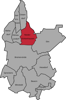
Location of Nieder Ochtenhausen in Bremervörde
|
|
Nieder Ochtenhausen is a district of the city of Bremervörde in the Rotenburg (Wümme) district in Lower Saxony .
Description of coat of arms
In the green field a left oblique stream in silver. In silver a windmill at the top right and a sailing ship at the bottom left.
Geographical location
Nieder Ochtenhausen is located in the Elbe-Weser triangle between Bremen , Bremerhaven and Hamburg about seven kilometers north of Bremervörde on the Oste River .
history
Nieder Ochtenhausen was first mentioned in a document in 1218. The navigation on the Oste was essential for the development of the place. The extracted peat could only be transported to customers in the cities by ship . In 1783, Councilor of Commerce Christian Ludwig Albrecht Patje from Hanover bought the estate. He invested heavily in Nieder Ochtenhausen, in addition to the windmill in the new Mühlheim district (built in 1787 on the highest point of the village), numerous craft businesses and new farms were built.
On March 1st, 1974 Nieder Ochtenhausen was incorporated into the city of Bremervörde.
geology
Nieder Ochtenhausen lies west of the Oste and southeast of the Mehe .
tourism
Nieder Ochtenhausen is on the German ferry route . The nearby Oste makes it an interesting area for anglers with a tidal range of around 1.5 meters.
Web links
Individual evidence
- ↑ Bremervörde and the localities
- ^ Federal Statistical Office (ed.): Historical municipality directory for the Federal Republic of Germany. Name, border and key number changes in municipalities, counties and administrative districts from May 27, 1970 to December 31, 1982 . W. Kohlhammer GmbH, Stuttgart / Mainz 1983, ISBN 3-17-003263-1 , p. 242 .


