
Heiligenhafen
| coat of arms | Germany map | |
|---|---|---|

|
Coordinates: 54 ° 22 ′ N , 10 ° 59 ′ E |
|
| Basic data | ||
| State : | Schleswig-Holstein | |
| Circle : | Ostholstein | |
| Height : | 7 m above sea level NHN | |
| Area : | 18.32 km 2 | |
| Residents: | 9122 (Dec. 31, 2019) | |
| Population density : | 498 inhabitants per km 2 | |
| Postal code : | 23774 | |
| Area code : | 04362 | |
| License plate : | OH | |
| Community key : | 01 0 55 021 | |
| LOCODE : | DE HHF | |
City administration address : |
Am Markt 4–5 23774 Heiligenhafen |
|
| Website : | ||
| Mayor : | Kuno Brandt (independent) | |
| Location of the city of Heiligenhafen in the Ostholstein district | ||
  |
||


Heiligenhafen ( Low German : Hilligenhaven ) is a small town in the Ostholstein district , Schleswig-Holstein , on the eastern tip of the Wagrien peninsula on the Baltic Sea .
geography
The town center is located on a bay (the artificially separated part of which is called an inland lake , but has access to the Baltic Sea), which is separated from the Baltic Sea by an upstream headland consisting of Steinwarder and Graswarder . The Graswarder is a bird sanctuary . There is a steep coast to the west of the village. The districts of Ortmühle and Strandhusen belong to Heiligenhafen .
history
Heiligenhafen is mentioned several times in the written sources of the 13th century.
The correct interpretation of the name, which has undergone several changes over the years, has not yet succeeded.
There are no exact sources about the first granting of city rights. According to documents, Heiligenhafen was enfeoffed in 1305 by Count Gerhard II at his castle in Grube with the "Lübschenrechte". After that, the Heiligenhafener were considered citizens and, in contrast to the population living in the surrounding area, could judge according to their own law.
The city suffered from a flood in 1320. Five years later, when Count Johann III. gave the Heiligenhafenern permission for the duty-free export of their products through a certificate, the city flourished. It became the main port of export for the Oldenburger Land . Due to the market rights granted , the city was allowed to give itself a city seal that still adorns the city coat of arms and the city flag. For the next centuries, Heiligenhafen was directly subordinate to the Danish king as a so-called "royal share" .
In 1391 the city burned down to eight houses. In 1428 it was completely destroyed by the Danish king Erik VII . The following calm and steady upward development was interrupted by the Thirty Years War . In 1625, Heiligenhafen had to sell the village of Klaustorf acquired in 1437 because of the growing need . From 1627 to 1630, the raging plague and brought the city to the brink of ruin. The following decades also brought new suffering to the population through wars, fires and storm surges . Peace did not return until 1720.
The wars in Schleswig-Holstein only marginally affected Heiligenhafen. In 1938 Heiligenhafen became a garrison town , and extensive barracks were built on the western edge of the city from 1935 onwards. After the Second World War , the Vagrian peninsula was declared a prison area by the British occupation forces and the captured German soldiers were locked in barracks and barns. In order to prevent the escape of the soldiers, the boats of the Heiligenhafen fishermen were driven into the roadstead and sunk there.
Due to the flow of refugees from the former East German territories , the population of Heiligenhafen rose by leaps and bounds from 3,500 to 10,700. The mayors and city councilors were faced with the task of creating new apartments for the refugees and displaced persons housed in large barracks. Through programs that were supported by the federal government, the state and the district, new residential buildings were built and the urban area of the city expanded considerably. The old town area with its streets and the market was largely preserved in its original form. From the 1970s onwards, the city began to be more touristically developed. a. with the construction of the holiday center and the development of the Steinwarder.
politics
City council

- Since the local elections on May 25, 2008 , the CDU had six, the SPD and the BfH (Citizens for Heiligenhafen) voters five each, the Greens two and the FDP one.
- In the local elections on May 26, 2013 , the CDU and SPD each had six seats. The Greens had two seats. The FDP received one seat and the BfH four mandates. The high number of invalid votes was noticeable, it was 9.5 percent of the votes cast.
- In the local elections on May 6, 2018 , the movement in the urban system (BisS) also moved into the city council.
coat of arms
Blazon : “In silver over silver and blue waves in which four silver fish swim in pairs on top of each other, a continuous red ashlar wall; on it six lined up red gabled houses with gates and Uhlenloch, the second and fifth decorated with a red flag, inside a silver nettle leaf; between the flags a red shield with a silver nettle leaf. "
The coat of arms goes back to the historic city seal of Heiligenhafen. In later seal forms, the number of gabled houses changes, and the fish in the shield base have also been left out. When the coat of arms was established in the 1930s and 50s, the seal image was traced back to the oldest known version. Apparently there was no approval; but since the mid-1950s the city has been using the coat of arms that was designed at the time and recorded in the description. The city was founded between 1249 and 1259 by the Counts of Holstein, presumably under the granting of Luebian law. The main occupations of the inhabitants, trade and fishing, favored by the location on the Baltic Sea, are represented by the merchants' houses and the fish in the coat of arms. The city rule of the Counts of Holstein is particularly emphasized by the triple quotation of the nettle leaf. With the establishment of cities, in addition to Heiligenhafen such as Kiel, Neustadt and Oldenburg, the rulers of the rulers of the district of Schauenburg wanted to counterbalance Lübeck's monopoly. The grounds of Heiligenhafen are rich in antiquity. The name could therefore go back to a former pagan shrine. The colors of the coat of arms are those of the country.
The coat of arms was designed by the Brunsbüttel heraldist Willy "Horsa" Lippert .
flag
The flag was approved on August 27, 1987.
The figures of the city coat of arms on white flag cloth, tinged according to the flag, shifted slightly from the center towards the pole, as far as they do not go through like waves and walls from flag edge to flag edge.
Town twinning
Heiligenhafen has partnerships with Rerik (Mecklenburg-Western Pomerania) and the Maribo municipality (Denmark).
Culture and sights
The Große Bürgergilde zu Heiligenhafen is one of the oldest guilds in Germany and celebrates the so-called "Guild Festival" every June.
In the local history museum Heiligenhafen a historical insight into the city history of Heiligenhafen is granted.
Just outside of Heiligenhafen are the Bronze Age burial mounds Struckberg and Tweltenberge , which are protected as a natural monument .
The rescue boat Heiligenhafen of the German Society for the Rescue of Shipwrecked People is stationed in Heiligenhafen .
Buildings
The center of the city is the old town area with the city church , which is over 750 years old , the market square redesigned in 1992 with the town hall built as a residential building from 1882 and the town houses, some of which have been renovated as part of urban development funding. This old town area is separated in a west-east direction by Bergstraße and Thulboden and in south-north direction by Mühlenstraße and Brückstraße. Well-preserved houses from centuries past can be found in the town center and around the port.

Local history museum, built in 1904 as a municipal savings and lending bank

Old salt storage

Steeple
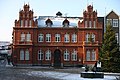
town hall
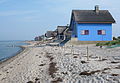
historic beach houses on the Graswarder


The Heiligenhafen lighthouse is located on the steep coast west of the city, and the Heiligenhafen lighthouse in the Strandhusen district .
The 435 meter long Heiligenhafen pier was opened on June 28, 2012.
Regular events
The ten-day "Harbor Festival" has been celebrated annually since 1977. Since 1982 the music festival "Rock am Kirchberg" has taken place as part of the port festival.
Economy and Infrastructure
schools
- General education schools
- Theodor Storm School (elementary school with a support center), Friedrich-Ebert-Straße
and branch in Großenbrode, Am Süderfeld (a total of 265 students in 11 classes / 35 supervised) - Warder School (community school), Sundweg (314 students in 12 classes)
- Theodor Storm School (elementary school with a support center), Friedrich-Ebert-Straße
Student numbers from the school year 2018/2019.
- Vocational schools
- AMEOS Institute North, Friedrich-Ebert-Straße:
- School for Nursing Professions (43 students in 3 classes)
- Elderly Care School (9 students in 2 classes)
- AMEOS Institute North, Friedrich-Ebert-Straße:
Student numbers from the school year 2018/2019.
- Other educational institutions
- Volkshochschule Heiligenhafen, Wittrockstrasse
- City library, Lauritz-Maßmann-Straße
Churches and ecclesiastical institutions
- City Church (Evangelical-Lutheran), Kirchenstrasse
- St. Ansgar (Roman Catholic), Kirchhofstrasse
- New Apostolic Church, Kirchhofstrasse
- Free Evangelical Congregation (FeG), Hafenstrasse
- Cemetery, Kirchhofstrasse
- Diakonie welfare station, Am Lindenhof
- evang.-luth. Kindergarten "Martin Luther", Kurzer Kamp

Heiligenhafen is a state-approved seaside spa and is still a fishing location today . There is also a psychiatric hospital here. To the west of the city center is a holiday park, to the east is the Fehmarnsund Bridge along the Vogelfluglinie . Tourism, fishing, trade, crafts and the clinic for psychiatry, psychotherapy and neurology as well as various banks and authorities determine the employment structure of the population today. A new industrial park "Dührenkamp" was opened in 1998 in the east of the city. An intermunicipal industrial area together with the city of Oldenburg in Holstein , the municipality of Großenbrode , the municipality of Gremersdorf and the city of Heiligenhafen is being planned as a further commercial and industrial location. In Heiligenhafen there are many wholesale grocery stores specializing in Danish customers, which mainly sell a range of alcoholic beverages that is inexpensive compared to Denmark. This leads to a so-called "supply tourism" - mainly with buses from Scandinavia - to which the German discounters have now also adjusted.
tourism

Tourism is one of the main sources of income in Heiligenhafen. At the end of the 19th century, when sea trade lost its importance, agriculture, handicrafts and fishing remained the main sources of income. Tourism was added in 1872. In 1895 the "Deutsche Badegesellschaft Heiligenhafen" was founded, which leased the entire coastal strip from the city from the Hohe Ufer to the eastern tip of the Graswarder for 100 years . She tried to revive tourism in Heiligenhafen. However, this only succeeded until 1914. After that, the company had practically ceased to exist. Only after the Second World War did the seaside resort expand continuously to this day.
From 1969 to 1972, a holiday park with around 1700 apartments was built in the west outside of the village and in the immediate vicinity of the beach. In this area there are now leisure facilities such as a rehabilitation center, a wellness center, children's playgrounds, tennis courts, a cinema as well as skittle and bowling alleys and a music and event pavilion with 200 seats. In the area of the main bathing beach, an adventure area (barbecue area, event stage, beach volleyball, football field, boules court, skater area, playgrounds) has been created.
In recent years the city has invested 35 million euros in the infrastructure. The indoor pool was replaced by the "Aktiv-Hus". There are two new promenades along the inland lake as well as at the yacht and fishing port. A newly created starting point is the pier opened in 2013 . Two new hotels and holiday apartments were built in the vicinity.
The needs of disabled and elderly people have also been thought of with a handicapped-accessible bathing jetty, a wheelchair-accessible beach path and appropriate play equipment.
There is a marina with around 1000 berths close to the city center.

port

Marina with a view of the Graswarder

Pier

Beach at the Steinwarder

Active Hus


traffic
Road traffic
Heiligenhafen is located at the end of the federal motorway 1 (connection point Heiligenhafen-Ost), from where two federal roads ( B207 and B501 ) continue in different directions. Another junction is at the "Heiligenhafen-Mitte" driveway. In the further course, the B 207 following the A 1 towards Fehmarn and Denmark is to be expanded to four lanes by 2018 as a hinterland connection of the planned Fehmarnbelt Fixed Link . Europastraße 47 runs along the A 1 / B 207 via the "Vogelfluglinie", which reaches the Puttgarden ferry port on the Fehmarnbelt after around 25 km .
Bus transport
Two intercity bus routes operate in Heiligenhafen, which are operated by Autokraft as part of the Ostholstein Transport Association:
- 5804 Neustadt (Holst) - Oldenburg (Holst) - Heiligenhafen (- Burg - Puttgarden) and
- 5811 (Oldenburg -) Heiligenhafen - Burg (Fehmarn) - Puttgarden
There are also two inner-city lines. From April to September until 2011 the bathing bus ran once a day to and from Hamburg.
Rail transport
The geographically closest train station is in the neighboring community of Großenbrode . Regional trains stop here . The next station where long-distance trains stop is in Oldenburg in Holstein . Both stations are on the Lübeck – Puttgarden railway line and are connected to Heiligenhafen by regular buses.
The Heiligenhafen station as the end of a branch line from the Vogelfluglinie with the formerly smallest depot of the Deutsche Bundesbahn existed as an independent service until 1963 and has since been closed. The tracks were dismantled, the route is partly built over and is now used as a cycle path to Ortmühle.

Station street side (1983)

Disused station, already without tracks (1983)


Personalities
Born in Heiligenhafen
- Johann Badendorp († 1517), Council Secretary of the Hanseatic City of Lübeck
- Moritz Hartmann (1657–1695), ship officer
- Eugen Petersen (1836–1919), archaeologist
- Wilhelm Jensen (1837–1911), poet and writer
- Hans Ludwig Moraht (1879–1945), diplomat, German envoy to Estonia, Lithuania and Uruguay, special envoy to the Balkans
- Gerhard Poppendiecker (* 1937), politician (SPD)
- Holger Bodendorf , (1967 *) Cooking with a star in the Michelin guide awarded
Connected to Heiligenhafen
- Carl Nicolaus Kähler (1804–1871), Evangelical Lutheran pastor, educator, and local history researcher, was rector at the community school and deacon at the city church from 1830–1839.
- Theodor Storm (1817–1888) lawyer and writer, was inspired by a stay in Heiligenhafen in 1881 to write the novella Hans and Heinz Kirch , the setting of which is located here.
- Fritz Graßhoff (1913–1997), draftsman, painter and writer, was interned here after the war and wrote in 1945 Das Heiligenhafener Sternsingerspiel .
- Rainer Jarchow (* 1941), the initiator of a German AIDS aid organization, was a pastor here for three years
- Torsten Albig (* 1963), former Prime Minister of Schleswig-Holstein (SPD), childhood in Heiligenhafen
literature
- Heinrich Scholtz: Chronicle of the city of Heiligenhafen. 1743 (reprint: Heiligenhafen 1930, DNB 576105384 ).
- Elisabeth Fuchs: Heiligenhafen. Lifestyles in a small German town oriented towards the tourism industry. Dissertation . Göttingen 1985, DNB 860452654 .
- Hans Friedrich Rothert : The beginnings of the cities of Oldenburg, Neustadt and Heiligenhafen. Wachholtz, Neumünster 1970, DNB 457978120 .
- Jörgen Heinritz: 650 years of Heiligenhafen port. A documentation. Ed .: City of Heiligenhafen. Eggers, Heiligenhafen 2000, ISBN 3-9802249-2-9 .
- Norbert Fischer , Sonja Jüde, Stefanie Helbig, Gabriele Rieck (eds.): The Graswarder - coastal landscape of the Baltic Sea. DOBU-Verlag, Hamburg 2011, ISBN 978-3-934632-42-4 .
- Otto Rohkohl: The little Heiligenhafenbuch. Heiligenhafen 1992.
Web links
Individual evidence
- ↑ North Statistics Office - Population of the municipalities in Schleswig-Holstein 4th quarter 2019 (XLSX file) (update based on the 2011 census) ( help on this ).
- ↑ Schleswig-Holstein topography. Vol. 4: Groß Sarau - Holstenniendorf . 1st edition Flying-Kiwi-Verl. Junge, Flensburg 2004, ISBN 978-3-926055-75-0 , p. 208 ( dnb.de [accessed on May 3, 2020]).
- ↑ https://www.ndr.de/nachrichten/schleswig-holstein/kommunalwahl_2018/heiligenhafen274.html
- ↑ Schleswig-Holstein's municipal coat of arms
- ↑ hafenfesttage.de: Information on “Rock am Kirchberg”. Retrieved June 8, 2020 .
- ↑ Statistical Office for Hamburg and Schleswig-Holstein: Directory of general education schools in Schleswig-Holstein 2018/2019
- ↑ Statistical Office for Hamburg and Schleswig-Holstein: Directory of vocational schools in Schleswig-Holstein 2018/2019
- ↑ When, where was, 2017 - A special information from the Ostholsteiner Anzeiger, p. 12
- ↑ bahn.de: Bäderbus discontinued ( Memento from March 21, 2012 in the Internet Archive ) (German, accessed on September 18, 2013)
Ahrensbök | Old brim | Bad Schwartau | Beschendorf | Bosau | Dahme | Damlos | Eutin | Fehmarn | Göhl | Gremersdorf | Grömitz | Großenbrode | Pit | Harmsdorf | Heiligenhafen | Heringsdorf | Kabelhorst | Kasseedorf | Kellenhusen (Baltic Sea) | Lensahn | Malente | Manhagen | Neukirchen | Neustadt in Holstein | Oldenburg in Holstein | Ratekau | Riepsdorf | Scharbeutz | Schashagen | Schönwalde am Bungsberg | Sierksdorf | Stockelsdorf | Süsel | Timmendorfer Strand | Wangels