
Neukirchen (Ostholstein)
| coat of arms | Germany map | |
|---|---|---|
_Wappen.png)
|
Coordinates: 54 ° 19 ' N , 11 ° 1' E |
|
| Basic data | ||
| State : | Schleswig-Holstein | |
| Circle : | Ostholstein | |
| Office : | Oldenburg-Land | |
| Height : | 11 m above sea level NHN | |
| Area : | 28.5 km 2 | |
| Residents: | 1167 (Dec. 31, 2019) | |
| Population density : | 41 inhabitants per km 2 | |
| Postcodes : | 23779, 23777 | |
| Area code : | 04365 | |
| License plate : | OH | |
| Community key : | 01 0 55 031 | |
| Office administration address: | Behind the Höfe 2 23758 Oldenburg i. H. |
|
| Website : | ||
| Mayor : | Bernd Bruhn ( CDU ) | |
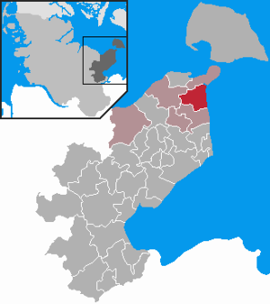
| Location of the community Neukirchen in the Ostholstein district | ||
  |
||


Neukirchen is a municipality in the Ostholstein district in Schleswig-Holstein . It is located in the Wagrien countryside directly on the Baltic Sea and has a 5.6 km long beach. Bürau, Georgshof, Godderstorf , Klingstein, Kraksdorf, Löhrstorf, Michaelsdorf, Meeschendorf, Meeschendorfer Weide, Ölendorf, Ostermade, Sahna, Satjewitz, Seekamp, Sütel and Wulfshof are in the municipality.
history
The place was first mentioned as Kerghvelde in 1259 and is named after its church. The brick Romano-Gothic St. Anthony's Church was donated by Adolf IV von Schauenburg and Holstein in 1244/45 .
The first dry milk in Germany was produced in the dairy in 1914. The dairy was closed in the early 1960s.
Gut Löhrstorf
The noble estate Löhrstorf (formerly Löhrstorff) was first mentioned in the 14th century. The mansion is a massive building with a mansard roof and is located on a spacious park. The courtyard island with the manor house and farm buildings is surrounded by a wide moat and can only be reached via two bridges. In 1384 the estate was mentioned as the property of the Cistercian monastery Reinfeld , but soon after came into the possession of the von Rantzaus family and stayed with this large family for over 300 years. After that, Löhrstorf had different owners, such as von Bülow , von Hardenberg and von Reventlow . In 1722, under Baron Cuno Josua von Bülow, an extension was built to the manor house and furnished with valuable stucco work attributed to the Italian plasterer Giuseppe Moggia. Since 1904 the estate has been owned by the Paarmann family, who had the manor house converted in 1920 by the Lübeck architect Wilhelm Bräck . Room painting by Albert Aereboe . Garden design based on plans by Harry Maasz . Today, several hundred hectares of arable land belong to Gut Löhrstorf, some of which are directly adjacent to the farm.
Good Seekamp
Gut Seekamp was built in 1798 and was initially a Meierhof . Later the estate was a farm, which then and now includes hundreds of hectares of land. Today Gut Seekamp belongs to the Rickert family, who also built the Seekamp campsite on the Großenbroder Binnensee in the 1950s .
Good Satjewitz
The village of Satjewitz, from which the estate emerged, was first mentioned in 1433.
Good Bürau
The village of Bürau, from which the estate emerged, was first mentioned in the middle of the 15th century. Today only the manor house and the farm buildings remain.
Good Godderstorf
The village of Godderstorf, from which the estate emerged, was first mentioned at the beginning of the 15th century. In the middle of the 18th century Godderstorf was a noble estate, the manor house was built in 1880.
Klingstein - Klingsteen
Klingstein was formerly a village of ten Slavic husbands. Then it belongs to a bikarie of the church in Lütjenburg. In 1612 a house was orphaned. In 1663 the village belonged to Gut Satjewitz, later it was sold to Gut Löhrstorf. At the beginning of 1903, the Berliner Landbank bought the Löhrstorf estate and parceled it out. The main courtyard came to its current owner on August 1, 1904. Klingstein also became independent on this date.
politics
Community representation
The 2018 election resulted in the following:
coat of arms
Blazon : "Above a blue corrugated shield, inside two outwardly inclined golden ears of wheat, in silver a red church with a steeple between two green linden trees."
economy
The community is predominantly agricultural. In addition, tourism is an essential branch of the economy. There are around ten campsites and several holiday apartments in the municipality.
traffic
The federal road 501 Heiligenhafen - Neustadt in Holstein and the Lübeck – Puttgarden railway line run through the municipality . The nearest train stations, Großenbrode and Oldenburg (Holst) , are located five and ten kilometers to the northeast and southwest, respectively. But there are daily buses through the various small towns, with which you can reach the nearest train stations. You can travel to Puttgarden ( Fehmarn ) or Lübeck from both train stations . To this end, Neukirchen from the community dial-Ostholstein the car power supply.
Personalities
- The composer and organist Christian Flor (1626–1697) was born in Neukirchen.
- The poet Doris Runge (* 1943) grew up in Neukirchen.
literature
- Gunther Kirmis: Talking stones. The Neuenkirchen gravestones. Michael Imhof Verlag, Petersberg 2019. ISBN 978-3-7319-0943-9 .
Web links
Individual evidence
- ↑ North Statistics Office - Population of the municipalities in Schleswig-Holstein 4th quarter 2019 (XLSX file) (update based on the 2011 census) ( help on this ).
- ↑ Schleswig-Holstein's municipal coat of arms
Ahrensbök | Old brim | Bad Schwartau | Beschendorf | Bosau | Dahme | Damlos | Eutin | Fehmarn | Göhl | Gremersdorf | Grömitz | Großenbrode | Pit | Harmsdorf | Heiligenhafen | Heringsdorf | Kabelhorst | Kasseedorf | Kellenhusen (Baltic Sea) | Lensahn | Malente | Manhagen | Neukirchen | Neustadt in Holstein | Oldenburg in Holstein | Ratekau | Riepsdorf | Scharbeutz | Schashagen | Schönwalde am Bungsberg | Sierksdorf | Stockelsdorf | Süsel | Timmendorfer Strand | Wangels