Kellenhusen (Baltic Sea)
| coat of arms | Germany map | |
|---|---|---|

|
Coordinates: 54 ° 11 ' N , 11 ° 4' E |
|
| Basic data | ||
| State : | Schleswig-Holstein | |
| Circle : | Ostholstein | |
| Management Community : | Groemitz | |
| Height : | 0 m above sea level NHN | |
| Area : | 8.17 km 2 | |
| Residents: | 1125 (Dec. 31, 2019) | |
| Population density : | 138 inhabitants per km 2 | |
| Postal code : | 23746 | |
| Area code : | 04364 | |
| License plate : | OH | |
| Community key : | 01 0 55 025 | |
| Address of the municipal administration: |
Kirchenstrasse 11 23743 Grömitz |
|
| Website : | ||
| Mayoress : | Nicole Kohlert (FWK) | |
| Location of the community of Kellenhusen (Baltic Sea) in the Ostholstein district | ||
Kellenhusen (Baltic Sea) is a municipality in the Ostholstein district in Schleswig-Holstein . Bokhorst, Vogelsang and Rittbruch are in the municipality.
Geography and traffic
Kellenhusen is a Baltic Sea spa , which is about 18 km northeast of Neustadt in Holstein , almost 16 km (depending on the beeline ) southeast of Oldenburg in Holstein and about 4 km south of the eastern end of the Oldenburger Graben . The place is located in the Wagrien landscape between the forest and the Baltic Sea and on the Bay of Lübeck between Grömitz and Dahme .
To the west of Kellenhusen, federal highway 501 runs from Neustadt towards Fehmarn . The nearest train station is Lensahn on the Lübeck – Puttgarden railway line , about 14 km west of Kellenhusen. The autokraft bus line 5800 connects Kellenhusen with Neustadt (in summer also Sierksdorf) and Grube, Dahme, Oldenburg (Holstein) and Heiligenhafen.
Kellenhusen is also connected to the Baltic Sea Cycle Route , which leads around the Baltic Sea within the European EuroVelo network.
politics
Community representation
In the 2013 local elections, there was a political change in Kellenhusen: After the FWK constituency had an absolute majority for five years, the CDU won the relative majority. In the 2018 election, the Voting Community FWK was again the strongest force. After the 2018 election , the seats were divided as follows:
administration
Kellenhusen was part of the Grube office from 1970 to 2006 . Since then, Kellenhusen and the municipalities of Dahme and Grube have formed an administrative partnership with the municipality of Grömitz , which also carries out the administrative business for the three municipalities.
coat of arms
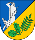
Blazon : “Divided obliquely by blue and gold on the left. At the top of the partition a silver fisherman standing in the boat, at the bottom a green beech, oak and ash leaf each placed in a fan shape. "
economy
Kellenhusen used to be a fishing village. Today the place lives mainly from tourism, which is characterized by families with children. Due to numerous activities and facilities, the place is also becoming more and more popular with other age groups. There are now opportunities for football , beach volleyball , mini golf , tennis , swimming , surfing , kite surfing , sailing , archery , air rifle shooting and disc golf , for which Germany's largest facility is located in Kellenhusen.
In the summer of 2017, Kellenhusen was used, along with other locations, as a filming location for the ZDF two-part series “The Disappeared Family”.
Attractions
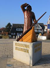
The fisherman is a sculpture by the sculptor Axel Süphke .
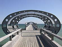
After the old pier was damaged by bad weather in 2004/2005, a new 305 m long pier with three themed islands was to be built by the 2006 season. The pier was inaugurated on Friday, June 8th, 2007. The new pier offers three "themed islands" opportunities to relax and swim. Smaller ships can moor at the pier head, which improves the tourism of the place through better connections with the big neighbors like Lübeck or Travemünde and Fehmarn . You can also get married on the pier.
The (see main article) 5-mark oak is located in the Kellenhusener forest.
Web links
- Municipality of Kellenhusen (Baltic Sea) in the administrative community of Grömitz
- Kellenhusen health resort administration
Individual evidence
- ↑ North Statistics Office - Population of the municipalities in Schleswig-Holstein 4th quarter 2019 (XLSX file) (update based on the 2011 census) ( help on this ).
- ↑ Community directory online of the statistical offices of the federal and state governments
- ↑ Schleswig-Holstein topography. Vol. 5: Holt - Krokau . 1st edition Flying-Kiwi-Verl. Junge, Flensburg 2005, ISBN 978-3-926055-79-8 , pp. 194 ( dnb.de [accessed July 20, 2020]).
- ↑ Baltic Sea Cycle Route - Baltic Sea Schleswig Holstein. Retrieved May 6, 2017 .
- ↑ translator2: EuroVelo 10 - EuroVelo. Retrieved May 6, 2017 .
- ↑ Schleswig-Holstein's municipal coat of arms
- ^ ZDF crime thriller: Cold horror in Kellenhusen. Retrieved January 8, 2019 .


