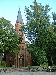
Schönwalde on the Bungsberg
| coat of arms | Germany map | |
|---|---|---|

|
Coordinates: 54 ° 11 ′ N , 10 ° 45 ′ E |
|
| Basic data | ||
| State : | Schleswig-Holstein | |
| Circle : | Ostholstein | |
| Office : | Ostholstein-Mitte | |
| Height : | 106 m above sea level NHN | |
| Area : | 39.06 km 2 | |
| Residents: | 2604 (Dec. 31, 2019) | |
| Population density : | 67 inhabitants per km 2 | |
| Postal code : | 23744 | |
| Area code : | 04528 | |
| License plate : | OH | |
| Community key : | 01 0 55 038 | |
| LOCODE : | DE 64Q | |
| Office administration address: | Am Ruhsal 2 23744 Schönwalde am Bungsberg |
|
| Website : | ||
| Mayor : | Winfried Saak (independent) | |
| Location of the community Schönwalde am Bungsberg in the Ostholstein district | ||
Schönwalde am Bungsberg is a municipality in the Ostholstein district in Schleswig-Holstein . Bungsberghof, Halendorf, Hobstin, Kniphagen, Langenhagen, Mönchneversdorf, Neu-Petersdorf, Rethwisch, Scheelholz, Stolperhufen and Vogelsang are located in the municipality. Gut Mönchneversdorf was also located in Schönwalde.
Geography and traffic
Schönwalde is located about 10 km northeast of Eutin and 10 km north of Neustadt in Holstein in the Holstein Switzerland Nature Park . The federal motorway 1 runs from Lübeck in the direction of Fehmarn about 10 km to the east . The Mönchneversdorfer pond is located in the municipality .
The community has had the name affix on Bungsberg since 1954.
history
The place and the church were first mentioned in 1240. Until 1460 the entire area belonged to the Cismar monastery .
politics
Community representation
The 2018 election led to the result shown in the adjacent diagrams.
coat of arms
Blazon : "Above a green three-mountain in silver, covered with a golden trefoil cross, a green oak branch symmetrically arranged from four leaves and two fruits, the upper leaves of which enclose a red rose with a golden clump and green sepals."
Village museum
In the former school, which was built in 1823, is now the village and school museum, which is based on the local history collection of the school.
Sons and daughters (selection)
- Heinrich Hüttmann (1868–1928), politician (SPD), member of the Reichstag
Web links
Individual evidence
- ↑ North Statistics Office - Population of the municipalities in Schleswig-Holstein 4th quarter 2019 (XLSX file) (update based on the 2011 census) ( help on this ).
- ↑ Schleswig-Holstein topography. Vol. 9: Schönberg - Tielenhemme . 1st edition Flying-Kiwi-Verl. Junge, Flensburg 2007, ISBN 978-3-926055-91-0 , p. 14 ( dnb.de [accessed July 30, 2020]).
- ↑ Schleswig-Holstein's municipal coat of arms
- ↑ History to touch in Ostholstein. Retrieved on March 13, 2018 (German).


