
Federal motorway 1
| Bundesautobahn 1 in Germany | |||||||||||||||||||||||||||||||||||||||||||||||||||||||||||||||||||||||||||||||||||||||||||||||||||||||||||||||||||||||||||||||||||||||||||||||||||||||||||||||||||||||||||||||||||||||||||||||||||||||||||||||||||||||||||||||||||||||||||||||||||||||||||||||||||||||||||||||||||||||||||||||||||||||||||||||||||||||||||||||||||||||||||||||||||||||||||||||||||||||||||||||||||||||||||||||||||||||||||||||||||||||||||||||||||||||||||||||||||||||||||||||||||||||||||||||||||||||||||||||||||||||||||||||||||||||||||||||||||||||||||||||||||||||||||||||||||||||||||||||||||||||||||||||||||||||||||||||||||||||||||||||||||||||||||||||||||||||||||||||||||||||||||||||||||||||||||||||||||||||||||||||||||||||||||||||||||||||||||||||||||||||||||||||||||||||||||||||||||||||||||||||||||||||||||||||||||||||||||||||||||||||||||||||||||||||||||||||||||||||||||||||||||||||||||||||||||||||||||||||||||||||||||||||||||||||||||||||||||||||||||||||||||||||||||||||||||||||||||||||||||||||||||||||||||||||||||||||||||||||

|
|||||||||||||||||||||||||||||||||||||||||||||||||||||||||||||||||||||||||||||||||||||||||||||||||||||||||||||||||||||||||||||||||||||||||||||||||||||||||||||||||||||||||||||||||||||||||||||||||||||||||||||||||||||||||||||||||||||||||||||||||||||||||||||||||||||||||||||||||||||||||||||||||||||||||||||||||||||||||||||||||||||||||||||||||||||||||||||||||||||||||||||||||||||||||||||||||||||||||||||||||||||||||||||||||||||||||||||||||||||||||||||||||||||||||||||||||||||||||||||||||||||||||||||||||||||||||||||||||||||||||||||||||||||||||||||||||||||||||||||||||||||||||||||||||||||||||||||||||||||||||||||||||||||||||||||||||||||||||||||||||||||||||||||||||||||||||||||||||||||||||||||||||||||||||||||||||||||||||||||||||||||||||||||||||||||||||||||||||||||||||||||||||||||||||||||||||||||||||||||||||||||||||||||||||||||||||||||||||||||||||||||||||||||||||||||||||||||||||||||||||||||||||||||||||||||||||||||||||||||||||||||||||||||||||||||||||||||||||||||||||||||||||||||||||||||||||||||||||||||||
|
|
|||||||||||||||||||||||||||||||||||||||||||||||||||||||||||||||||||||||||||||||||||||||||||||||||||||||||||||||||||||||||||||||||||||||||||||||||||||||||||||||||||||||||||||||||||||||||||||||||||||||||||||||||||||||||||||||||||||||||||||||||||||||||||||||||||||||||||||||||||||||||||||||||||||||||||||||||||||||||||||||||||||||||||||||||||||||||||||||||||||||||||||||||||||||||||||||||||||||||||||||||||||||||||||||||||||||||||||||||||||||||||||||||||||||||||||||||||||||||||||||||||||||||||||||||||||||||||||||||||||||||||||||||||||||||||||||||||||||||||||||||||||||||||||||||||||||||||||||||||||||||||||||||||||||||||||||||||||||||||||||||||||||||||||||||||||||||||||||||||||||||||||||||||||||||||||||||||||||||||||||||||||||||||||||||||||||||||||||||||||||||||||||||||||||||||||||||||||||||||||||||||||||||||||||||||||||||||||||||||||||||||||||||||||||||||||||||||||||||||||||||||||||||||||||||||||||||||||||||||||||||||||||||||||||||||||||||||||||||||||||||||||||||||||||||||||||||||||||||||||||
| map | |||||||||||||||||||||||||||||||||||||||||||||||||||||||||||||||||||||||||||||||||||||||||||||||||||||||||||||||||||||||||||||||||||||||||||||||||||||||||||||||||||||||||||||||||||||||||||||||||||||||||||||||||||||||||||||||||||||||||||||||||||||||||||||||||||||||||||||||||||||||||||||||||||||||||||||||||||||||||||||||||||||||||||||||||||||||||||||||||||||||||||||||||||||||||||||||||||||||||||||||||||||||||||||||||||||||||||||||||||||||||||||||||||||||||||||||||||||||||||||||||||||||||||||||||||||||||||||||||||||||||||||||||||||||||||||||||||||||||||||||||||||||||||||||||||||||||||||||||||||||||||||||||||||||||||||||||||||||||||||||||||||||||||||||||||||||||||||||||||||||||||||||||||||||||||||||||||||||||||||||||||||||||||||||||||||||||||||||||||||||||||||||||||||||||||||||||||||||||||||||||||||||||||||||||||||||||||||||||||||||||||||||||||||||||||||||||||||||||||||||||||||||||||||||||||||||||||||||||||||||||||||||||||||||||||||||||||||||||||||||||||||||||||||||||||||||||||||||||||||||
 |
|||||||||||||||||||||||||||||||||||||||||||||||||||||||||||||||||||||||||||||||||||||||||||||||||||||||||||||||||||||||||||||||||||||||||||||||||||||||||||||||||||||||||||||||||||||||||||||||||||||||||||||||||||||||||||||||||||||||||||||||||||||||||||||||||||||||||||||||||||||||||||||||||||||||||||||||||||||||||||||||||||||||||||||||||||||||||||||||||||||||||||||||||||||||||||||||||||||||||||||||||||||||||||||||||||||||||||||||||||||||||||||||||||||||||||||||||||||||||||||||||||||||||||||||||||||||||||||||||||||||||||||||||||||||||||||||||||||||||||||||||||||||||||||||||||||||||||||||||||||||||||||||||||||||||||||||||||||||||||||||||||||||||||||||||||||||||||||||||||||||||||||||||||||||||||||||||||||||||||||||||||||||||||||||||||||||||||||||||||||||||||||||||||||||||||||||||||||||||||||||||||||||||||||||||||||||||||||||||||||||||||||||||||||||||||||||||||||||||||||||||||||||||||||||||||||||||||||||||||||||||||||||||||||||||||||||||||||||||||||||||||||||||||||||||||||||||||||||||||||||
| Basic data | |||||||||||||||||||||||||||||||||||||||||||||||||||||||||||||||||||||||||||||||||||||||||||||||||||||||||||||||||||||||||||||||||||||||||||||||||||||||||||||||||||||||||||||||||||||||||||||||||||||||||||||||||||||||||||||||||||||||||||||||||||||||||||||||||||||||||||||||||||||||||||||||||||||||||||||||||||||||||||||||||||||||||||||||||||||||||||||||||||||||||||||||||||||||||||||||||||||||||||||||||||||||||||||||||||||||||||||||||||||||||||||||||||||||||||||||||||||||||||||||||||||||||||||||||||||||||||||||||||||||||||||||||||||||||||||||||||||||||||||||||||||||||||||||||||||||||||||||||||||||||||||||||||||||||||||||||||||||||||||||||||||||||||||||||||||||||||||||||||||||||||||||||||||||||||||||||||||||||||||||||||||||||||||||||||||||||||||||||||||||||||||||||||||||||||||||||||||||||||||||||||||||||||||||||||||||||||||||||||||||||||||||||||||||||||||||||||||||||||||||||||||||||||||||||||||||||||||||||||||||||||||||||||||||||||||||||||||||||||||||||||||||||||||||||||||||||||||||||||||||
| Operator: |
|
||||||||||||||||||||||||||||||||||||||||||||||||||||||||||||||||||||||||||||||||||||||||||||||||||||||||||||||||||||||||||||||||||||||||||||||||||||||||||||||||||||||||||||||||||||||||||||||||||||||||||||||||||||||||||||||||||||||||||||||||||||||||||||||||||||||||||||||||||||||||||||||||||||||||||||||||||||||||||||||||||||||||||||||||||||||||||||||||||||||||||||||||||||||||||||||||||||||||||||||||||||||||||||||||||||||||||||||||||||||||||||||||||||||||||||||||||||||||||||||||||||||||||||||||||||||||||||||||||||||||||||||||||||||||||||||||||||||||||||||||||||||||||||||||||||||||||||||||||||||||||||||||||||||||||||||||||||||||||||||||||||||||||||||||||||||||||||||||||||||||||||||||||||||||||||||||||||||||||||||||||||||||||||||||||||||||||||||||||||||||||||||||||||||||||||||||||||||||||||||||||||||||||||||||||||||||||||||||||||||||||||||||||||||||||||||||||||||||||||||||||||||||||||||||||||||||||||||||||||||||||||||||||||||||||||||||||||||||||||||||||||||||||||||||||||||||||||||||||||||
| further operator: |
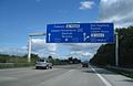
A1 mobil GmbH & Co. KG (between Buchholzer Dreieck and Bremer Kreuz ) |
||||||||||||||||||||||||||||||||||||||||||||||||||||||||||||||||||||||||||||||||||||||||||||||||||||||||||||||||||||||||||||||||||||||||||||||||||||||||||||||||||||||||||||||||||||||||||||||||||||||||||||||||||||||||||||||||||||||||||||||||||||||||||||||||||||||||||||||||||||||||||||||||||||||||||||||||||||||||||||||||||||||||||||||||||||||||||||||||||||||||||||||||||||||||||||||||||||||||||||||||||||||||||||||||||||||||||||||||||||||||||||||||||||||||||||||||||||||||||||||||||||||||||||||||||||||||||||||||||||||||||||||||||||||||||||||||||||||||||||||||||||||||||||||||||||||||||||||||||||||||||||||||||||||||||||||||||||||||||||||||||||||||||||||||||||||||||||||||||||||||||||||||||||||||||||||||||||||||||||||||||||||||||||||||||||||||||||||||||||||||||||||||||||||||||||||||||||||||||||||||||||||||||||||||||||||||||||||||||||||||||||||||||||||||||||||||||||||||||||||||||||||||||||||||||||||||||||||||||||||||||||||||||||||||||||||||||||||||||||||||||||||||||||||||||||||||||||||||||||||
| Start of the street: |
Heiligenhafen ( 54 ° 22 ′ N , 11 ° 1 ′ E ) |
||||||||||||||||||||||||||||||||||||||||||||||||||||||||||||||||||||||||||||||||||||||||||||||||||||||||||||||||||||||||||||||||||||||||||||||||||||||||||||||||||||||||||||||||||||||||||||||||||||||||||||||||||||||||||||||||||||||||||||||||||||||||||||||||||||||||||||||||||||||||||||||||||||||||||||||||||||||||||||||||||||||||||||||||||||||||||||||||||||||||||||||||||||||||||||||||||||||||||||||||||||||||||||||||||||||||||||||||||||||||||||||||||||||||||||||||||||||||||||||||||||||||||||||||||||||||||||||||||||||||||||||||||||||||||||||||||||||||||||||||||||||||||||||||||||||||||||||||||||||||||||||||||||||||||||||||||||||||||||||||||||||||||||||||||||||||||||||||||||||||||||||||||||||||||||||||||||||||||||||||||||||||||||||||||||||||||||||||||||||||||||||||||||||||||||||||||||||||||||||||||||||||||||||||||||||||||||||||||||||||||||||||||||||||||||||||||||||||||||||||||||||||||||||||||||||||||||||||||||||||||||||||||||||||||||||||||||||||||||||||||||||||||||||||||||||||||||||||||||||
| End of street: |
Saarbrücken ( 49 ° 16 ′ N , 6 ° 57 ′ E ) |
||||||||||||||||||||||||||||||||||||||||||||||||||||||||||||||||||||||||||||||||||||||||||||||||||||||||||||||||||||||||||||||||||||||||||||||||||||||||||||||||||||||||||||||||||||||||||||||||||||||||||||||||||||||||||||||||||||||||||||||||||||||||||||||||||||||||||||||||||||||||||||||||||||||||||||||||||||||||||||||||||||||||||||||||||||||||||||||||||||||||||||||||||||||||||||||||||||||||||||||||||||||||||||||||||||||||||||||||||||||||||||||||||||||||||||||||||||||||||||||||||||||||||||||||||||||||||||||||||||||||||||||||||||||||||||||||||||||||||||||||||||||||||||||||||||||||||||||||||||||||||||||||||||||||||||||||||||||||||||||||||||||||||||||||||||||||||||||||||||||||||||||||||||||||||||||||||||||||||||||||||||||||||||||||||||||||||||||||||||||||||||||||||||||||||||||||||||||||||||||||||||||||||||||||||||||||||||||||||||||||||||||||||||||||||||||||||||||||||||||||||||||||||||||||||||||||||||||||||||||||||||||||||||||||||||||||||||||||||||||||||||||||||||||||||||||||||||||||||||||
| Overall length: | 774 km | ||||||||||||||||||||||||||||||||||||||||||||||||||||||||||||||||||||||||||||||||||||||||||||||||||||||||||||||||||||||||||||||||||||||||||||||||||||||||||||||||||||||||||||||||||||||||||||||||||||||||||||||||||||||||||||||||||||||||||||||||||||||||||||||||||||||||||||||||||||||||||||||||||||||||||||||||||||||||||||||||||||||||||||||||||||||||||||||||||||||||||||||||||||||||||||||||||||||||||||||||||||||||||||||||||||||||||||||||||||||||||||||||||||||||||||||||||||||||||||||||||||||||||||||||||||||||||||||||||||||||||||||||||||||||||||||||||||||||||||||||||||||||||||||||||||||||||||||||||||||||||||||||||||||||||||||||||||||||||||||||||||||||||||||||||||||||||||||||||||||||||||||||||||||||||||||||||||||||||||||||||||||||||||||||||||||||||||||||||||||||||||||||||||||||||||||||||||||||||||||||||||||||||||||||||||||||||||||||||||||||||||||||||||||||||||||||||||||||||||||||||||||||||||||||||||||||||||||||||||||||||||||||||||||||||||||||||||||||||||||||||||||||||||||||||||||||||||||||||||||
| of which in operation: | 748 km | ||||||||||||||||||||||||||||||||||||||||||||||||||||||||||||||||||||||||||||||||||||||||||||||||||||||||||||||||||||||||||||||||||||||||||||||||||||||||||||||||||||||||||||||||||||||||||||||||||||||||||||||||||||||||||||||||||||||||||||||||||||||||||||||||||||||||||||||||||||||||||||||||||||||||||||||||||||||||||||||||||||||||||||||||||||||||||||||||||||||||||||||||||||||||||||||||||||||||||||||||||||||||||||||||||||||||||||||||||||||||||||||||||||||||||||||||||||||||||||||||||||||||||||||||||||||||||||||||||||||||||||||||||||||||||||||||||||||||||||||||||||||||||||||||||||||||||||||||||||||||||||||||||||||||||||||||||||||||||||||||||||||||||||||||||||||||||||||||||||||||||||||||||||||||||||||||||||||||||||||||||||||||||||||||||||||||||||||||||||||||||||||||||||||||||||||||||||||||||||||||||||||||||||||||||||||||||||||||||||||||||||||||||||||||||||||||||||||||||||||||||||||||||||||||||||||||||||||||||||||||||||||||||||||||||||||||||||||||||||||||||||||||||||||||||||||||||||||||||||||
| of which in planning: | 26 km | ||||||||||||||||||||||||||||||||||||||||||||||||||||||||||||||||||||||||||||||||||||||||||||||||||||||||||||||||||||||||||||||||||||||||||||||||||||||||||||||||||||||||||||||||||||||||||||||||||||||||||||||||||||||||||||||||||||||||||||||||||||||||||||||||||||||||||||||||||||||||||||||||||||||||||||||||||||||||||||||||||||||||||||||||||||||||||||||||||||||||||||||||||||||||||||||||||||||||||||||||||||||||||||||||||||||||||||||||||||||||||||||||||||||||||||||||||||||||||||||||||||||||||||||||||||||||||||||||||||||||||||||||||||||||||||||||||||||||||||||||||||||||||||||||||||||||||||||||||||||||||||||||||||||||||||||||||||||||||||||||||||||||||||||||||||||||||||||||||||||||||||||||||||||||||||||||||||||||||||||||||||||||||||||||||||||||||||||||||||||||||||||||||||||||||||||||||||||||||||||||||||||||||||||||||||||||||||||||||||||||||||||||||||||||||||||||||||||||||||||||||||||||||||||||||||||||||||||||||||||||||||||||||||||||||||||||||||||||||||||||||||||||||||||||||||||||||||||||||||||
|
State : |
|||||||||||||||||||||||||||||||||||||||||||||||||||||||||||||||||||||||||||||||||||||||||||||||||||||||||||||||||||||||||||||||||||||||||||||||||||||||||||||||||||||||||||||||||||||||||||||||||||||||||||||||||||||||||||||||||||||||||||||||||||||||||||||||||||||||||||||||||||||||||||||||||||||||||||||||||||||||||||||||||||||||||||||||||||||||||||||||||||||||||||||||||||||||||||||||||||||||||||||||||||||||||||||||||||||||||||||||||||||||||||||||||||||||||||||||||||||||||||||||||||||||||||||||||||||||||||||||||||||||||||||||||||||||||||||||||||||||||||||||||||||||||||||||||||||||||||||||||||||||||||||||||||||||||||||||||||||||||||||||||||||||||||||||||||||||||||||||||||||||||||||||||||||||||||||||||||||||||||||||||||||||||||||||||||||||||||||||||||||||||||||||||||||||||||||||||||||||||||||||||||||||||||||||||||||||||||||||||||||||||||||||||||||||||||||||||||||||||||||||||||||||||||||||||||||||||||||||||||||||||||||||||||||||||||||||||||||||||||||||||||||||||||||||||||||||||||||||||||||||
| Development condition: | 2 × 2 and 2 × 3 lanes | ||||||||||||||||||||||||||||||||||||||||||||||||||||||||||||||||||||||||||||||||||||||||||||||||||||||||||||||||||||||||||||||||||||||||||||||||||||||||||||||||||||||||||||||||||||||||||||||||||||||||||||||||||||||||||||||||||||||||||||||||||||||||||||||||||||||||||||||||||||||||||||||||||||||||||||||||||||||||||||||||||||||||||||||||||||||||||||||||||||||||||||||||||||||||||||||||||||||||||||||||||||||||||||||||||||||||||||||||||||||||||||||||||||||||||||||||||||||||||||||||||||||||||||||||||||||||||||||||||||||||||||||||||||||||||||||||||||||||||||||||||||||||||||||||||||||||||||||||||||||||||||||||||||||||||||||||||||||||||||||||||||||||||||||||||||||||||||||||||||||||||||||||||||||||||||||||||||||||||||||||||||||||||||||||||||||||||||||||||||||||||||||||||||||||||||||||||||||||||||||||||||||||||||||||||||||||||||||||||||||||||||||||||||||||||||||||||||||||||||||||||||||||||||||||||||||||||||||||||||||||||||||||||||||||||||||||||||||||||||||||||||||||||||||||||||||||||||||||||||||
|
Course of the road
|
|||||||||||||||||||||||||||||||||||||||||||||||||||||||||||||||||||||||||||||||||||||||||||||||||||||||||||||||||||||||||||||||||||||||||||||||||||||||||||||||||||||||||||||||||||||||||||||||||||||||||||||||||||||||||||||||||||||||||||||||||||||||||||||||||||||||||||||||||||||||||||||||||||||||||||||||||||||||||||||||||||||||||||||||||||||||||||||||||||||||||||||||||||||||||||||||||||||||||||||||||||||||||||||||||||||||||||||||||||||||||||||||||||||||||||||||||||||||||||||||||||||||||||||||||||||||||||||||||||||||||||||||||||||||||||||||||||||||||||||||||||||||||||||||||||||||||||||||||||||||||||||||||||||||||||||||||||||||||||||||||||||||||||||||||||||||||||||||||||||||||||||||||||||||||||||||||||||||||||||||||||||||||||||||||||||||||||||||||||||||||||||||||||||||||||||||||||||||||||||||||||||||||||||||||||||||||||||||||||||||||||||||||||||||||||||||||||||||||||||||||||||||||||||||||||||||||||||||||||||||||||||||||||||||||||||||||||||||||||||||||||||||||||||||||||||||||||||||||||||||
The federal highway 1 (abbreviation: BAB 1 ) - short form: Autobahn 1 (abbreviation: A 1 ) - is a German federal highway that leads from Heiligenhafen on the Baltic Sea via Lübeck , Hamburg , Bremen , Dortmund , Cologne and Trier to Saarbrücken . With a length of 749 kilometers, it is the third longest motorway in Germany after the federal autobahn 7 and federal autobahn 3 and, with seven federal states, the one that runs through most of the federal states.
The section between Heiligenhafen and Hamburg is also known as the Vogelfluglinie , and from Lübeck to the Ruhr area also as the Hansalinie . The name Eifelautobahn is common between Cologne and Trier . There is still a vacant lot in this section to this day.
course
Schleswig-Holstein
The Schleswig-Holstein section of the A 1, which belongs to the so-called Vogelfluglinie , begins at the Heiligenhafen -Ost junction as a four-lane extension of the B 207 coming from the Puttgarden ferry port on the island of Fehmarn . On the Wagrien peninsula , the A 1 briefly runs west, then south, past the East Holstein cities of Oldenburg in Holstein and Neustadt in Holstein . In the Lübeck Bay area , the Baltic Sea coast is touched for a length of about 10 km, which at Haffkrug is approached up to a kilometer away. Before reaching the Hanseatic city of Lübeck further south, the A 226 coming from Travemünde joins the triangle Bad Schwartau and the A 1 becomes six-lane. After crossing the Lübeck city area, there is a connection to the Baltic Sea A 20 in the direction of Rostock at the Lübecker Kreuz . The motorway now leads in a south-westerly direction through the Stormarn district , past the small towns of Reinfeld and Bad Oldesloe to the Bargteheide motorway junction , the current end point of the A 21 from Kiel . The eastern Hamburg suburbs of Bargteheide and Ahrensburg are also connected. Shortly before reaching the Hamburg city area, the A 24 ( Hamburg-Horn - Berlin ) crosses the A 1 at an elongated junction, the Hamburg-Ost junction .
six-lane route at the Lübeck junction

The A1 reaches the Hanseatic city at the Hamburg-Ost junction
_(1000m)_-_geo-en.hlipp.de_-_5239.jpg)
.jpg)
Hamburg
In Hamburg, the eastern district of Billstedt is first passed and the Hamburg-Billwerder transshipment station is crossed in an approximately 240-meter-long tunnel. Behind it, the A 25 branches off to Geesthacht at the Hamburg-Südost triangle . After crossing the Norderelbe on a cable-stayed bridge , the main carriageway of the A1 joins the main carriageway coming from Veddel at the triangle Norderelbe , which connects Hamburg city center via Elbbrücken as the A 255 . After the triangle, the main carriageway of the A1 runs south again, crosses the Süderelbe near Hamburg-Harburg and, already in Lower Saxony , crosses the A 39 to Lüneburg at the Maschener Kreuz junction . At the directly following Horster Dreieck , the main carriageway of the A1 changes again, the continuous route forms the A7 to Hanover . From here the autobahn leads westwards in four lanes , only from the Buchholzer Dreieck , which connects the A 261 as a connection to the A 7 in the direction of Flensburg , are six lanes again.

Billwerder-Moorfleet tunnel under the Hamburg-Billwerder transshipment station
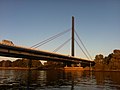
Cable-stayed bridge over the Norderelbe

Before the triangle Norderelbe

.jpg)

Lower Saxony and Bremen
As far as Bremen , the route runs through largely flat and sparsely populated land, far away from larger cities, and has six lanes throughout. The A 27 ( Cuxhaven - Walsrode ) is crossed at the Bremer Kreuz , which is in Lower Saxony . The A1 now connects the southern districts of Bremen. Only a few kilometers of the route are actually in the area of the Free Hanseatic City of Bremen , where the Weser is crossed. After Bremen, at the Stuhr triangle near Delmenhorst , the A 28 branches off in the direction of Oldenburg , it also serves as a fast route to the northern Netherlands .
As far as the Ahlhorner Heide triangle , where the A 29 from Wilhelmshaven joins, the A 1 has four lanes and the Wildeshauser Geest Nature Park is crossed. Then it goes - partly six, partly four lanes - south again towards Osnabrück . At Neuenkirchen-Vörden , the Dammer Mountains are the first foothills of the low mountain range . At Bramsche , the Wiehengebirge is crossed and Osnabrück is bypassed to the northwest. After crossing the branch canal in Osnabrück , the state border with North Rhine-Westphalia is crossed three times before the A 30 ( Netherlands - Bad Oeynhausen ) is crossed at the Lotte / Osnabrück junction .

New six-lane route between Hamburg and Bremen

Crossing the Weser in Bremen

At the triangle Stuhr shortly after Bremen


North Rhine-Westphalia
The crossing of the Teutoburg Forest in the Tecklenburger Land to the south requires unusually steep inclines and declines. From Lengerich the landscape flattens out again and a few kilometers later merges into the Münsterland . The Muenster / Osnabrueck Airport is located just off the A1 and has its own connection point since of 2010. After the six-lane bypass from Münster , the A 43 branches off to the northern Ruhr area at the Münster-Süd intersection . Further south, the A 2 ( Oberhausen - Hanover - Berlin ) crosses at Hamm at the Kamener Kreuz ; The A 1 will now consist of six lanes as far as Cologne and crosses the A 44 ( Dortmund - Kassel ) a few kilometers further at Unna . After connecting the Dortmund suburb of Schwerte, the A 45 to Frankfurt am Main crosses at the Westhofener Kreuz and the A 1 passes Hagen . Shortly before Wuppertal , the A 43 and the A 46 to Düsseldorf are again connected at the Wuppertal-Nord junction . In a south-westerly direction, it goes through the hilly Bergisches Land past the cities of Wuppertal and Remscheid , where the lanes in the Blombachtal are partially separated, before from the Leverkusen junction with the junction with the A 3 ( Emmerich- Frankfurt am Main- Passau ) A 1 forms the northern and western part of the motorway ring around Cologne . After the Leverkusen-West junction ( A 59 to Düsseldorf), the motorway crosses the Rhine on a large cable-stayed bridge, passes the Ford factory in Cologne-Niehl and crosses the A 57 ( Goch - Krefeld - Cologne ) at the Cologne-Nord junction. . After changing direction to the south, the Cologne district of Lövenich is crossed in a 1.5 km long noise protection enclosure and the Kölner Ring is left again at the Köln-West junction with the A 4 ( Aachen –Köln– Olpe ).
The section known as the Eifel motorway begins again with four lanes . First, the Ville , a wooded ridge southwest of Cologne, is crossed before the A 61 from Venlo joins the Erfttal triangle . As far as the Bliesheim near Brühl junction, the A1 runs with the A61 on a shared, six-lane route. After leaving this one crosses the plain of the Jülich-Zülpicher Börde , bypasses Euskirchen and then climbs up into the Eifel . The provisional end of the northern part of the motorway is reached at the Blankenheim junction. Closing the gap through the Eifel to Kelberg is in the planning phase.

Kamen Cross after the renovation (2009)

Route east of Dortmund

In the Blombachtal near Wuppertal - Ronsdorf

Lövenich enclosure with glass roof

The A1 in the Jülich-Zülpicher Börde near Euskirchen

The current end of the motorway at Blankenheim


Rhineland-Palatinate and Saarland
Beyond the state border with Rhineland-Palatinate , the A1 starts again at the Kelberg junction . A few kilometers further, the A 48 to Koblenz begins at the Vulkaneifel triangle near Daun . At Wittlich the motorway descends from the Eifel and connects to the A 60 in the direction of Belgium . In the direction of the Rhine-Main area , the mostly four-lane federal highway 50 branches off with the Hochmosel crossing . The Moselle is crossed at Schweich and the A 602 to Trier , which also connects to the A 64 to Luxembourg , branches off. Then the motorway climbs up from the Moselle valley and crosses the heights of the Hunsrück . Beyond the state border with Saarland , at the Nonnweiler triangle , you have to leave the main lane to stay on the A 1, as the continuous route forms the A 62 in the direction of Pirmasens (see TOTSO ).
The last section of the A1 to Saarbrücken is characterized by numerous curves with which the Saar-Nahe-Bergland is crossed. In Illingen crossing A 8 ( Luxembourg - Pirmasens ) on the cross Saarbrücken which A 1 runs along the edge of the Saar carbon Forest and ends at the junction Saarbrücken-Burbach (150) in the development area of the LAP district Malstatt . The subsequent B 268 continues into the city center of the Saarland capital.

East of Trier


Sections as a European route
- E 47 : Heiligenhafen - Lübeck motorway junction
- E 22 : Lübeck motorway junction - Stuhr motorway junction
- E 37 : Autobahn triangle Stuhr - Autobahn junction Köln-Nord
- E 31 : Autobahn junction Köln-Nord - Autobahn junction Bliesheim
- E 29 : Bliesheim - Blankenheim motorway junction
- E 44 : Vulkaneifel - Wittlich-Mitte motorway triangle
- E 44 / E 42 : Wittlich-Mitte - Wittlich motorway junction
- E 44 : Wittlich motorway junction - Moseltal motorway triangle
- E 422 : Motorway triangle Moseltal - Saarbrücken-Burbach
history
Today's Autobahn 1 is essentially based on route planning, some of which date back to the Weimar Republic . During the Nazi era, sections of the route were built from 1934, mainly in the north, although the continuation to Cologne was not completed until after the Second World War in the 1960s. By the mid-1980s, it was extended in the north to Oldenburg in Holstein and in the south to Saarbrücken , although there is still a vacant lot in the Eifel that has been closed since the late 1990s. At the same time, an extension from Oldenburg to Heiligenhafen was realized.
1926 to 1933 - First plans
The first plans for roads that were to be reserved exclusively for motorized individual traffic came up with the advancement of motorization in the 1920s. The HaFraBa eV association ( association for the construction of a road for express motor vehicle traffic from Hamburg via Frankfurt am Main to Basel ), founded at the end of 1926, initially designed a trunk road from Hamburg via Frankfurt am Main to the Swiss border to Basel under Robert Otzen . Later a northern continuation to Lübeck and a branch to Bremen and an extension through Switzerland to northern Italy were planned. As early as 1927, the association designed an all-German trunk road network. Numerous trunk road plans were then drawn up by the early 1930s. From 1929 on, the term “ autobahn” , coined by Otzen, was used instead of the previously usual name Nur-Autostraße . Most of these plans already contained connections between the North German Hanseatic cities, the Ruhr area , the Rhineland and, in some cases, the Saarland .
Due to a lack of support from the state authorities, financing through user fees ( tolls ) was considered, the amount and payment of which was disagreed. The HaFraBa plans could therefore no longer be implemented at the time of the Weimar Republic. The Cologne – Bonn route was the first motorway to be opened in 1932 by the then mayor of Cologne, Konrad Adenauer . However, this project was mainly initiated by the Rhenish provincial government, which wanted to redistribute the then relatively dense traffic in the Rhineland to more modern roads and create jobs at the time of the global economic crisis .
1934 to 1942 - Reichsautobahn construction
Although the NSDAP, represented in the Reichstag , initially strongly criticized and rejected the highways plans (“luxury roads of the rich”), after Hitler came to power in 1933 it pushed for the construction of the autobahn in order to create jobs. The HaFraBa association was initially renamed GEZUVOR ("Society for the preparation of the Reichsautobahn eV"), before work on the first Reichsautobahn between Frankfurt am Main , Darmstadt and Mannheim began in September of the same year . Praised by the National Socialists as a “world first”, only the HaFraBa plans, which had been ready for construction since 1932, were implemented and the Cologne – Bonn motorway, which opened a year earlier, was degraded to a country road. A model was also taken from Benito Mussolini's fascism , during whose reign the first roads reserved for motor traffic ( Autostrada dei Laghi ) were opened as early as 1924 .
As part of a “second labor battle”, the construction of new Reichsautobahn began on March 21, 1934 in 22 places in the German Reich. The declared goal of the Nazi regime was the construction of 1000 km of new Reichsautobahn per year - essentially HaFraBa plans, which were recorded in most maps from the 1920s. Construction has also started on two sections of today's BAB 1. It was the Hamburg – Lübeck and Hamburg – Bremen routes.
Hamburg – Bremen
The groundbreaking ceremony for the construction work on the section between Hamburg and Bremen took place on March 21, 1934 near Oyten . After only two years, the 71-kilometer section between the Dibbersen and Oyten junctions was opened to traffic on July 25, 1936 as part of a propaganda event. The construction of this route was done entirely without the use of heavy equipment; instead, many unemployed people were forced to do labor. In 1937 the section between the Oyten junction and the Bremer Kreuz as well as the subsequent part of today's BAB 27 to Bremen-Burglesum was completed.
Hamburg and Harburg-Wilhelmsburg , which was incorporated into Hamburg on April 1, 1938 , were connected from the south in 1939 by the construction of a motorway bridge over the Süderelbe. This north-south route was already prepared for the planned Reichsautobahn Hamburg – Hanover, which was carried out as a prestigious project by the National Socialists as part of the HaFraBa planning from the 1920s. The junction to Bremen from the north-south route near Horst (today's Horster triangle ) was already designed as a trumpet-shaped motorway triangle.
The continuation of the route from Bremen via Osnabrück to the Ruhr area could no longer be realized due to the outbreak of World War II and therefore did not get beyond the planning stage. Only the Kamener Kreuz with the Reichsautobahn Ruhrgebiet – Berlin (today's BAB 2 ) northeast of Dortmund was structurally completed in 1937, but it could not be used due to the missing north-south autobahn, which was only being excavated towards the south. It was not until the 1950s and 1960s that the Hansalinie from Bremen to Dortmund was fully completed.
Hamburg – Lübeck


Another route, the construction of which began in March 1934, was the Reichsautobahn route 18 from Hamburg to Lübeck . Preparatory work for the route construction took place in January 1934. It began at the Horner roundabout in Hamburg-Horn (today the western end point of the A 24 ) and led to today's Lübeck-Zentrum junction. This section was opened to traffic on May 13, 1937.
A year later, on May 1, 1938, the continuation of the line to Lübeck-Siems was released (today A 226 ). North of the exit, which was then called Lübeck , the lanes of the 2 × 2-lane autobahn from Hamburg converged into three lanes 17 meters wide (with side shoulders). There was no structural separation of directions as the middle lane was intended for overtaking in both directions. Today's branch line to Lübeck-Siems (today's A 226 ) was designed in the same way. This construction was by no means intended as a temporary solution in the 1930s; instead, it was assumed that a full extension is not necessary here, as the traffic volume on these remote routes would not be so high in the future either.
At the point where the Hamburg-Ost junction is today, a motorway junction ( Barsbütteler Dreieck ) was planned at that time , at which both a section of the planned Hamburg motorway ring to the south-west and a motorway towards Berlin should branch off. The construction as an elongated junction with parallel lanes largely corresponded to the cross built in the 1960s. Although the construction of the cross, which included a 150 m long tunnel structure, began in 1937, work on the subsequent route towards Berlin was discontinued in October 1939. During the Second World War, an assembly hall for the Harburg armaments company MENIBUM (Metallwerke Niedersachsen Brinckmann & Mergell) was located in the tunnel from 1943 to 1945 under the code name Kolibri .
After the occupation of Denmark in World War II , a bridge connection over the Fehmarnsund ( Vogelfluglinie ) and an extension of the Reichsautobahn to Copenhagen were planned. Earthworks and bridge construction work on the island of Lolland up to Guldborgsund began in September 1941. This section is now in operation as the E 47 .
Ruhr area – Cologne
A direct motorway connection between Cologne and Dortmund was planned under the name Ruhrtangente , which, together with the Cologne – Düsseldorf – Oberhausen – Dortmund route (part of the Reichsautobahn Frankfurt – Ruhrgebiet – Berlin), was to form a motorway ring around the cities of the Ruhr area . During the construction of the autobahn from Oberhausen to Berlin near Kamen , northeast of Dortmund, preliminary payments were made as early as 1934 for a later autobahn junction in the shape of a clover with a north-south route. Construction of the central bridge structure began, and the earthworks for the connecting ramps in the cross were well advanced. Construction was also carried out on the approximately 8 km long route in a southerly direction from Kreuz to Unna . The preliminary work for a junction had already been completed south of Kamen. Nevertheless, it was no longer completed before the end of the Second World War and lay fallow.
Construction began in 1936 from the connection to the Ruhr area – Cologne – Frankfurt motorway near Leverkusen to the Schloss Burg / Wermelskirchen junction . Since the planned route led through very mountainous and wooded area, its construction was very complex and the construction of the actual roadway was only possible three years later. Numerous viaducts therefore had to be built. Seven bridges were built on the sections built before the war, all of which were designed as arched bridges with natural stone cladding. The approximately 6 km long section from Wermelskirchen to the Remscheid junction was built from 1937 to 1939 and opened to traffic in December 1939.
In some places between Unna and Remscheid, for example north of Hagen , clearing and earthworks were already in progress, but construction work was stopped when the war broke out. During the Second World War, although the unfinished route had no great strategic value, many valley bridges between Leverkusen and Remscheid were blown up - only the Höllenbach and Einsiedelstein valley bridges remained undamaged. After the end of the war, the reconstruction of the bridges began, so that the motorway could be used again from 1950.
Post war until 1970
With the economic boom in the 1950s, the construction of the autobahn was resumed in the still young Federal Republic of Germany, after the rubble had to be cleared and structures destroyed by the war, such as numerous large bridges, had to be restored in the immediate post-war period. First of all, numerous routes were completed, the construction of which continued during the Nazi era until a general construction freeze was imposed due to the war. This also includes the route from Dortmund to Cologne. A little later, in the 1960s, the construction of previously planned, but not yet started sections followed, which were realized with the help of new knowledge and modern standards in road construction.
Ruhrtangente Dortmund – Cologne
From 1951 work was carried out on the completion of this route, which began before the war, between Kamen and Leverkusen. The Leverkusen – Remscheid section, which was released in 1938 and 1939 and has numerous valley bridges, was made impassable in the last years of the war when many of these bridges were blown up by the Wehrmacht . From 1950, when the structures were rebuilt, the autobahn was open to traffic again.
First of all, the section between the Kamener Kreuz and the Unna junction was created . With the construction of what was then the Reichsautobahn Ruhrgebiet – Berlin, preliminary work was already carried out for a motorway junction in the shape of a cloverleaf and an earthwork connection to the south to the level of the B1 . When this line was completed in the 1950s, the junction ( Kamen-Zentrum ) between the Kreuz and Unna was also built. The Kamener Kreuz was opened as the second German motorway junction (after the Schkeuditzer Kreuz ) on October 21, 1956. The approximately 8 km long section finally went into operation in 1957. At the same time, the Kamen motorway maintenance depot went into operation on December 1, 1957.
The remaining sections were completed step by step. By 1956 the motorway reached from the west (Cologne) as far as Hagen . With the commissioning of the Hagen – Unna line in 1961, the Ruhr tangent was completed, so that, together with the Oberhausen – Frankfurt (today's BAB 3 ) and Oberhausen – Berlin (today's BAB 2 ) motorways, a motorway ring was created around the cities of the Ruhr area.
Southeast connection Hamburg
The link between the Hamburg – Lübeck and Hamburg – Hanover / Bremen motorways was built from 1960 to 1963. Planning as part of a motorway ring around Hamburg, which includes this route, dates back to 1939. The motorway junction at Barsbüttel , which was planned before the Second World War , was designed in accordance with the preliminary work in such a way that a possible expansion to the east towards Berlin was possible.
The most outstanding structure on this 13 km long stretch is the Moorfleet Norderelbbrücke , which was designed as a cable-stayed bridge . On May 15, 1963, this and the route were approved by the then Federal Minister of Transport, Hans-Christoph Seebohm .
The first 5 km long section of the transit motorway from Hamburg to Berlin was opened in 1978, whereby the tunnel, which served as an assembly hall for the armaments industry during the Second World War and which was filled in after the end of the war, was rebuilt and used to connect the northern carriageway. Initially there were also no connecting ramps from Bremen towards Hamburg-Horn; these were only added in 1981. From the east there are still no connecting ramps in the direction of Lübeck, as this driving relationship is via the B 404 from Schwarzenbek to Bargteheide .
Hansalinie Bremen – Dortmund
The extension of the route from Bremen to the Ruhr area, which was planned in the basic motorway network in 1933 (together with the Hamburg – Bremen route, which was already implemented before the war, was called the Hansalinie ) could no longer be tackled due to the Second World War. Planning was therefore only resumed after the war in the 1950s. In addition to the real purpose of the route, connecting the seaport cities of Lübeck , Hamburg and Bremen with the industrial centers in the Ruhr area, there was also the task of promoting the infrastructural development of the structurally weak areas between these metropolitan areas and the North Sea ports of East Frisia and the Oldenburger Land . For this reason, a route was planned far to the west from Bremen and finally to the south from around Cloppenburg . The alignment in the area of the Wildeshauser Geest with its numerous archaeological monuments was a challenge .
While plans from 1933 to 1937 included an eastern bypass from Münster , a western bypass was planned for the first time in 1938 as an alternative. A plan from 1940 envisaged an eastern bypass of Munster and a motorway link branching off north of Munster to the Ruhr area - Berlin near Gladbeck . This connection was realized in the 1970s and 1980s as the A 43 and connected to the A 1 southwest of Münster. Ultimately, an agreement was reached on three variants to be examined: west of Münster, a large area east of Münster or directly east of Münster parallel to the freight bypass railway .
With the resumption of route planning at the end of the 1950s, it was necessary to modify the old pre-war plans based on new knowledge in road construction. The section in the Bremen city area was influenced by the high groundwater level of the Wesermarsch when it was planned. The roadway is generally 2 m above the groundwater level, the Weser Bridge has a gradient of 9 m above the highest water level of the river.
North of Osnabrück , the first foothills of the low mountain range are crossed with the Dammer Mountains and the Wiehen Mountains , south of Osnabrück the Teutoburg Forest is crossed . When planning the route, attention had to be paid to a topographically favorable location at these points, which only permitted slight inclines and slopes. The motorway nevertheless has a height difference of around 100 m over a relatively short section. The practice that was common before the war, essentially laying the highway with long straights and relatively narrow arcs, was considered outdated and unsafe.
The western bypass, about 5 km from the city center, turned out to be the best possible way of connecting the city of Münster. The federal highways 219 , 54 and 51 , which run radially towards Münster , could thus be connected to the autobahn, which means that there are three options for reaching Münster from the autobahn without building additional feeder roads.
The section south of Münster to the Kamener Kreuz required an elevation of the roadway in the area where the Lippe and Datteln-Hamm Canal crossed in order to absorb possible subsidence that occurred again and again during the mining industry in the Ruhr area. The Werne colliery was located in the Werner district of Stockum , located directly on the motorway .
The final route of the motorway was in 1958 for the 20 km long section Bremer Kreuz - Delmenhorst -Ost, 1959 for the 92 km long section Lotte - Kamener Kreuz and 1962 for the 102 km long section Delmenhorst-Ost-Lotte by the Federal Minister of Transport Hans-Christoph Seebohm definitely.
The Bremer Kreuz – Bremen / Brinkum section was opened to traffic in 1963, and a year later, in 1964, it continued to Delmenhorst. In 1965 a section at Wildeshausen and the section from Münster to the Kamener Kreuz were completed, making the Kamener Kreuz passable in all four directions for the first time. In 1966, after the approval of two further sections west and east of Wildeshausen from Bremen to Cloppenburg , the motorway was already completed, and in 1967 to Holdorf . The complete gap from Holdorf to Münster was then completed in 1968.
Cologne Ring

Large parts of the Cologne motorway ring were built in the 1930s and 1940s. The eastern section between Leverkusen and Heumar was built as part of the Reichsautobahn Ruhrgebiet – Frankfurt from 1934 and opened to traffic in 1936. By 1941 a part of the southern ring between Heumar and Rodenkirchen was built , which opened the Reichsautobahn Ruhrgebiet – Frankfurt with the 1932 as the first autobahn in Germany by the then mayor of Cologne , Konrad Adenauer , but shortly after the National Socialists took over power, it became a regional road to Cologne –Bonn connected. Part of this route was also a suspension bridge over the Rhine , the Rodenkirchen Bridge . A continuation beyond Cologne to Aachen has already been implemented in parts, but it was completely completed after the Second World War in the 1950s.
Although a complete motorway ring around Cologne was also planned at that time, the northern and western sections were not attacked, especially since a complete construction freeze was imposed due to the Second World War. The need to close the motorway ring was recognized as early as the late 1950s. The planning worked out for this was essentially based on the route planned before the war. A larger deviation was only carried out at the western end for the connection to the Aachen – Cologne motorway, since the Cologne district of Lövenich was not bypassed to the west as originally planned, but to the east. The motorway junction was thus created northeast of Frechen . The reason was better connections to Cologne city center through connections to federal highways 55 and 264 .
The planning approval decision for this section of the motorway was issued in three parts in 1961 - on August 16, 1961 for the section on the left bank of the Rhine from Niehl to Frechen, on September 1, 1962 for the section on the right bank of the Rhine in the city of Leverkusen and on October 20, 1961 a separate decision for the Rhine bridge . The route to be realized contained 25 bridge structures, the longest of which is the 1061 m long Leverkusen Rhine Bridge . Four connection points were also created:
- East of the Rhine bridge a connection to the motorway-like B 8 to Düsseldorf
- To the west of the Rhine bridge, a cloverleaf-shaped connection to Industriestraße to the Rheinhafen Köln-Niehl with attached industrial areas
- To the west of the Rhine bridge a cloverleaf-shaped connection to the B 9 to the Cologne-Butzweilerhof airport at that time
- A junction with parallel ramps to the B 59 ( Venloer Straße )
First, the section between federal highways 55 (junction Cologne-Lövenich ) and 264 (junction Frechen ) with the Cologne-West junction, which connects the Aachen-Cologne motorway, was opened to traffic on October 10, 1962.
In July 1961, construction of the Leverkusen Rhine Bridge began, including two elevated roads to the east, a 527 m long steel structure and a 927 m long prestressed concrete structure. Around half of the 2.8 km long section on the right bank of the Rhine in the Leverkusen city area therefore runs on bridges. On the western elevated road, the Dhünn and some roads connecting the industrial site to the north (sewage treatment plant and hazardous waste dump of Bayer AG ) are crossed. The construction of the eastern elevated road in the densely built-up urban area was required by the city of Leverkusen due to the possible use of the areas below, which therefore also contributed to the construction costs. The two structures were completed in just 13 and 14 months respectively. Although the motorway was initially built with four lanes, the two bridge structures were already designed for a wider carriageway with six lanes.
The earthworks began in early 1963. Sealing the earth at the eastern abutment of the Rhine bridge over a length of 635 m was problematic, as the area here was used as a toxic waste dump for a long time. Around 300,000 m³ of the 10 to 12 m deep soil had to be removed and replaced with stable soil. The road surface was built in April 1964. Because of the numerous light sources in Leverkusen, such as the Bayer main plant south of the autobahn and the directly adjacent BayArena stadium (then Ulrich Haberland Stadium ), between the Cologne-Niehl junction and the Leverkusen junction street lighting installed in the median. These are the same superstructures that were installed on the neighboring Ruhr Area – Frankfurt motorway (today's BAB 3 ) in the early 1960s .
In 1965, the Cologne northern bypass was completed and opened along its entire length. The construction costs for this road project totaled around 167.3 million DM.
Eifel and Saar route
A motorway route from Cologne via Trier to Landstuhl was planned as part of the Reichsautobahn network as early as the 1930s. A cross-connection should branch off from this at Daun and lead via Koblenz to a motorway triangle with the route Ruhrgebiet – Frankfurt near Dernbach . The construction of the lines from Dernbach to Daun (operating line no. 53) and from Daun to Trier (operating line no. 50) finally began. The two sections of Dernbach – Koblenz and Kaisersesch - Wittlich were under construction until the war ceased . A concrete carriageway has already been laid over a 13.6 km stretch and 27 bridge structures have been completed. The rest of the route was under construction, and 17 other bridge structures were also started.
After the war, the resumption of planning was limited to a connection from Koblenz to the Ruhr-Frankfurt motorway. This section was planned as a federal motorway again from 1954. After a traffic survey was carried out in 1959, it was decided to continue building the line from Koblenz via Daun and Trier to Landstuhl, although it was to be designed as a single-lane B 408 federal road . In the 1960s, work was resumed on the entire stretch between Dernbach and Wittlich. From 1961 onwards, the individual sections were gradually opened to traffic as a single-lane motorized road in the old route. An outstanding structure along the route is the Bendorfer Bridge over the Rhine , which was opened on August 16, 1965. In the same year, the Dernbach – Koblenz and Kaisersesch – Hasborn sections were completed as a single lane. The section between Wittlich-Dorf and Hasborn, which was passable before the war but not cleared, was opened to traffic as early as 1964 in a festive ceremony. A short section near Hasborn could only be released on July 1, 1968, because since 1950 the French army, as the occupying power, had been using and clearing an earthwork section as an ammunition depot.
In 1967, the entire planning became part of the motorway network again, and the 408 federal road between Dernbach and Trier was rededicated as the 74 motorway . By 1970, the second lane was added so that the route also had the full cross-section of the motorway. At the same time, the last remaining gap between Koblenz and Mayen was closed.
When, in the 1950s, with the reintegration of the Saarland into the Federal Republic of Germany, the trunk road network was redesigned in what is now the smallest area in Germany, a powerful motor vehicle was planned from Saarbrücken to the north, which at Hermeskeil would connect to the Trier – Landstuhl motorway, which was still in the planning phase should meet. A crossing-free, two-lane motor vehicle road between Hermeskeil and Lebach and a four-lane carriageway without a median or structural middle division from Lebach to Saarbrücken were planned. Since the construction of this road in the immediate vicinity of Saarbrücken was classified as urgent, construction work began here, so that in 1960 the first section between Saarbrücken and Riegelsberg could be opened to traffic as the B 268 with four lanes . In 1964 the section between Illingen and Eppelborn was completed as part of the B 327 .
After the section between Riegelsberg and Illingen was cleared, a resolution by the German Bundestag called on the federal government to provide a connection to the Saarland road network to the north. Thus the road was rededicated as a motorway and given the designation A 171 . It took until the end of the 1970s until the entire length of the Saarland section was passable and connected to the Trier – Landstuhl line, especially since the original plans from the 1930s were abandoned and a new route was chosen because of this connection.
Due to the originally non-existent structural center separation, accidents due to wetness on the winding route were frequent. A central guardrail was therefore only installed later in the course of the upgrade. This explains the unusually narrow profile of the motorway in this area, which also has no hard shoulder here.
1970s to 1980s
In addition to the introduction of a new numbering system in Germany, work began in the 1970s and 1980s to expand from Lübeck north to Oldenburg in Holstein and from Cologne south to Euskirchen and further into the Eifel . In addition, with the gradual closing of the gap between Wittlich and Saarbrücken, the southern section was completed.
Introduction of the name Bundesautobahn 1
On January 1, 1975, a new, uniform numbering scheme was introduced for the motorways in the Federal Republic of Germany and West Berlin. Initially, only internally managed numbering was used and only the numbers of the European roads running along the route were indicated on the signposts, but the new national numbering was brought forward. A previously in demand plan national highways 1971-1985 described system, the by Berliner Ring the digit numbers A 1 zuordnete branching routes to A 6, could, also in view of the then still existing German division , not prevail. The A 1 would have been the Berlin – Hamburg route that was built in the 1970s and 1980s, i.e. the connection between the two largest German cities.
Internally, the route Puttgarden – Hamburg – Bremen – Dortmund – Cologne was as Autobahn 11 , Cologne– Erftstadt as part of Autobahn 14 (from the Dutch border at Goch - French border at Lauterburg ), Daun - Trier as part of Autobahn 74 ( Giessen - Luxemburg ), Trier– Nonnweiler as part of the Autobahn 76 (Trier– Stuttgart ) and Nonnweiler – Saarbrücken as Autobahn 171 .
With the introduction of the current system that assigned single-digit numbers to the most important long-distance routes, most of which were already planned as main routes during the Weimar Republic , the number BAB 1 was selected for the westernmost north-south connection ). A great advantage of the system, that also the leading number of two- and three-digit motorways assigned to a certain region, was that in the event of reunification , numbers could already be assigned for the motorway routes in the former GDR without any problems (these were essentially the ones previously for the West Berlin city highways assigned numbers in the 10 range).
Based on the lane change ( TOTSO ) required in some motorway junctions and triangles to stay on the BAB 1 , the earlier numbering can still be guessed on the basis of continuous routes - for example at Kreuz Bliesheim (continuous route from Cologne on to Koblenz, former Autobahn 14 ) or the Dreieck Nonnweiler (continuous route from Trier to Pirmasens , former Autobahn 76 ).
Oldenburg i. H. – Lübeck
Since the 1970s, the motorway from Lübeck has been built in sections in a northerly direction along the Baltic Sea coast to Oldenburg in Holstein . In 1975 the first section from Bad Schwartau to Neustadt in Holstein was completed. The Bad Schwartau triangle was created as a fork from and in the direction of Hamburg , the route that continued to Lübeck-Siems was dedicated as BAB 226 .
Instead of today's fork, there used to be a junction as a left-hand trumpet , which - in contrast to today - was passable in every direction. This triangle was still called the Eutin branch in the 1950s . The traversing route led north in the direction of Ratekau on the route of today's L 181 between the L 309 and the Sereetz junction of the BAB 1. Like the earlier route to Siems, this stretch of the route was also three-lane with central overtaking lanes. After about 1500 meters, the autobahn ended at a triangular junction south of Ratekau, where the route merged into the country road (today's L 309, then B 207) and came to an end. This threading was officially called Eutin as a motorway junction , which at that time was not a geographical, but a pure directional determination ( ⊙ ). With the further construction of the BAB 1 in a northerly direction, the Ratekau branch was cut off from the motorway network and downgraded to a state road. Before the road was fully repaired, it was preserved in its original condition until around 1990. The bridge crossing of Schwartauer Straße is striking: the bridge is still an original structure and is therefore wider as a motorway bridge than is necessary today.
Before the carriageway was widened in the course of the six-lane expansion south of the motorway triangle around 1983, the motorway crossed under Stockelsdorfer Strasse, which is located immediately to the south. Today it leads over it. About 500 meters south of the Schwartau triangle, around the beginning of the re-marking of the branching right lane, the old three-lane route deviated to the east and ran from then on about 130 meters parallel to the current route. An approximately 160 meter long section of this original route is still preserved today in a forest near Elisabethstrasse in Bad Schwartau ( ⊙ ).
In 1979 the BAB 1 was extended from Neustadt in Holstein to Lensahn , then in 1980 to Oldenburg in Holstein- Süd.
Eifel motorway Cologne – Blankenheim
In the 1950s and 1960s a motorway on the left bank of the Rhine was planned from the Dutch border at Goch to the French border at Lauterburg , which was built in sections from the mid-1960s. Internally, this connection had the route number A 14 . Part of the Cologne Northern Bypass , essentially the western part of the Cologne motorway ring completed in 1965, was to be included for the route. A continuation from Frechen in a southerly direction was already prepared, as was a cross with the later motorway towards Krefeld and on to Goch.
In 1972 the section from Frechen to Weilerswist was completed, while the other sections in the direction of Koblenz / Ludwigshafen were either completed or under construction. With the introduction of the new motorway numbers on January 1, 1975, the idea of a continuous motorway between the Dutch and French borders was discarded, so that the motorway sections that were mostly completed at that time were given different numbers: Between Goch and Cologne this was now the BAB 57 , between Erftstadt and Ludwigshafen part the BAB 61 ( Venlo - Hockenheim ) and between Ludwigshafen and Wörth am Rhein the BAB 65 (the section further to the federal border at Lauterburg has no longer been realized as a motorway). Only the short stretch between Cologne and Bliesheim, which was part of the former A 14 planning, was added to BAB 1. Based on the driving relationships in the Erfttal triangle and in the Bliesheim intersection , the course of the original continuous numbering can still be traced. BAB 1 and BAB 61 run on a common route between the two junctions.
From the mid-1970s, the gap between Bliesheim and Daun was tackled from the north. First, the section from the Bliesheim junction to the Wisskirchen junction was opened in 1977 , to Mechernich in 1981 and to the present-day end of the motorway at Blankenheim in 1982 .
Wittlich – Saarbrücken
The extension from Wittlich to Trier was carried out after the completion of the second carriageway between Koblenz and Wittlich in the early 1970s. After three years of construction, the section up to the Moselle valley triangle with the Moselle bridge near Schweich was completed in December 1974. At the same time, the BAB 602 , which is only a few kilometers long, was built as a feeder into Trier city center. Since Schweich planned a motorway triangle with a branching line to Luxembourg , which wanted to represent the westernmost section of the BAB 48, the entire motorway section between Schweich and Daun, where advance payments for a planned motorway triangle during the construction of this route, were given the double numbering of the BAB 1 / BAB 48 .
For the construction of the continuation of the route from Trier to the south, no reference was made to the old Reichsautobahn plans, as the new route should also connect the Saarland . However, as originally planned, the continuous roadway was designed as a Trier – Landstuhl route and the motorway to Saarbrücken near Nonnweiler branched off from it. Coming from the direction of Trier, you have to leave the main carriageway to continue on the BAB 1 to Saarbrücken, as this continues as the BAB 62 to Landstuhl and Pirmasens .
Between Reinsfeld and Eppelborn , where the section opened in the 1960s continues to Saarbrücken, the autobahn was gradually completed from 1975 to 1977, with the two-lane motorway between Eppelborn and Quierschied being extended by a second lane. This also resulted in the Nonnweiler triangle . To close the gap between Daun / Trier and Saarbrücken, only the section between the triangle Moselle valley and Reinsfeld was missing. This 20 km long stretch with two larger bridge structures ( Fellerbach and Molesbachtal Bridge ) was not completed until 1983, which meant that the BAB 1 between Daun and Saarbrücken was completely passable.
It was not until the reorganization of the German motorway network in 1992 that the double numbering between the triangle Vulkaneifel and Trier ceased. Since the Dernbach – Wetzlar section of the A 48 was no longer to be realized, the name of this was initially reduced to the Wasserbillig (Luxembourg border) –Dernbach triangle, and later only to the Vulkaneifel – Dernbach triangle. The background to this was the introduction of individual numbers for connection points. The section to the northwest of Trier on the Luxembourg border that had already been built was renamed BAB 64 , and the sections in Hessen that had already been completed were given new numbers ( BAB 480 and BAB 5 ). This double numbering is still present on some older signposts.
After 1990
From the end of the 1990s to the beginning of the 2000s, both the continuation from Oldenburg in Holstein in a northerly direction and the closing of the gap in the Eifel between Blankenheim and Daun were planned and in some cases already implemented.
North extension to Heiligenhafen
The extension from Oldenburg in Holstein to Heiligenhafen was realized by adding a second carriageway to the B 207 federal highway. On December 20, 2002, the section from the former end of the motorway south of Oldenburg in Holstein to the Oldenburg i H.-Nord junction along the Oldenburg bypass road was upgraded to a motorway. On August 21, 2005, the previous B 207, which had been extended to include a second lane, was upgraded to Federal Motorway 1 and opened to traffic. On August 25, 2008 the next piece followed up to the connection point Heiligenhafen-Mitte. The 3.5 km long section from Heiligenhafen-Mitte to behind Heiligenhafen-Ost, which also includes an unmanaged rest area ( Baltic Sea view ), was opened to traffic on July 6, 2012.
Further construction in the Eifel

The planned closure of the gap in the Eifel was pushed further by the Rhineland-Palatinate side. With the introduction of separate numbers for junctions, numerous double-numbered motorway sections were dropped and replaced by a single, continuous numbering. The section between Daun and Schweich, which has been given the double designation BAB 1 / BAB 48 since the introduction of today's motorway numbers in 1975 , was added exclusively to Federal Motorway 1. The BAB 48, originally planned as a route between the Luxembourg border near Wasserbillig via Daun , Koblenz , Dernbach , Wetzlar and Gießen to the Hattenbacher Dreieck , was reduced to the Daun – Dreieck Dernbach section and existing sections of the original route were added to other motorway numbers.
In the 1990s, the Vulkaneifel triangle was built near Daun , the construction of which was already planned in the 1930s. During the construction of the Koblenz – Wittlich federal highway in the 1960s, the forerunner of today's Autobahn 1 and 48, the earthworks were already completed. In July 1997 the motorway triangle was completed together with a 4 km long new line to the Daun junction (then Daun / Darscheid ). The Daun / Mehren junction was later renamed Mehren .
In 2005 the motorway was extended from Daun by 2.5 km to the north to a provisional connection at Rengen . This was closed in October 2010 when the A1 was extended by a further 3.8 km to the Gerolstein junction . On May 31, 2012, another 2.5 km of the motorway to the north was released to the Kelberg junction . The complete gap has not yet been implemented due to halting planning due to environmental guidelines.
List of traffic clearances
| section | year | km |
|---|---|---|
| AS Heiligenhafen-Ost - AS Heiligenhafen-Mitte | 2012 | 3.0 km |
| AS Heiligenhafen-Mitte - AS Gremersdorf | 2008 | 4.8 km |
| AS Gremersdorf - AS Oldenburg i. H.-North | 2005 | 3.3 km |
| AS Oldenburg i. H.-Nord - AS Oldenburg i. H.-South | 2002 | 4.2 km |
| AS Oldenburg i. H.-Süd - AS Lensahn | 1980 | 8.1 km |
| AS Lensahn - AS Neustadt i. H.-North | 1979 | 8.3 km |
| AS Neustadt i. H.-Nord - Triangle Bad Schwartau | 1975 | 19.7 km |
| Triangle Bad Schwartau - AS Lübeck-Zentrum | 1938 | 8.0 km |
| AS Lübeck-Zentrum - Kreuz Hamburg-Ost | 1937 | 50.0 km |
| Kreuz Hamburg-Ost - Dreieck Norderelbe | 1963 | 12.8 km |
| Triangle Norderelbe - AS HH-Harburg | 1939 | 4.7 km |
| AS HH-Harburg - Maschener Kreuz | 1938 | 8.0 km |
| Mesh Cross - AS Dibbersen | 1937 | 10.0 km |
| AS Dibbersen - AS Oyten | 1936 | 71.0 km |
| AS Oyten - Bremen Cross | 1937 | 3.0 km |
| Bremen Cross - AS Uphusen / Bremen-Mahndorf | 1962 | 1.8 km |
| AS Uphusen / Bremen-Mahndorf - AS Bremen / Brinkum | 1963 | 11.5 km |
| AS Bremen / Brinkum - AS Delmenhorst-Ost | 1964 | 7.0 km |
| AS Delmenhorst-Ost - AS Wildeshausen-Nord | 1966 | 19.6 km |
| AS Wildeshausen-Nord - AS Wildeshausen-West | 1965 | 8.2 km |
| AS Wildeshausen-West - AS Cloppenburg | 1966 | 13.8 km |
| AS Cloppenburg - AS Holdorf | 1967 | 27.0 km |
| AS Holdorf - Kreuz Münster-Süd | 1968 | 90.0 km |
| Cross Münster-Süd - Kamen Cross | 1965 | 36.7 km |
| Kamener Kreuz - Kreuz Dortmund / Unna | 1957 | 10.0 km |
| Dortmund / Unna junction - AS Hagen-West | 1961 | 20.0 km |
| AS Hagen-West - AS Wuppertal-Langerfeld | 1960 | 17.0 km |
| AS Wuppertal-Langerfeld - AS Remscheid | 1956 | 14.0 km |
| AS Remscheid - AS Burscheid | 1939 | 14.0 km |
| AS Burscheid - Kreuz Leverkusen | 1938 | 11.0 km |
| Cross Leverkusen - AS Köln-Lövenich | 1965 | 18.0 km |
| AS Köln-Lövenich - Kreuz Köln-West | 1962 | 2.0 km |
| Kreuz Köln-West - AS Erftstadt | 1971 | 1.4 km |
| AS Frechen - Kreuz Bliesheim | 1972 | 12.9 km |
| Cross Bliesheim - AS Wißkirchen | 1977 | 16.9 km |
| AS Wißkirchen - AS Bad Münstereifel / Mechernich | 1981 | 8.5 km |
| AS Bad Münstereifel / Mechernich - AS Blankenheim | 1982 | 13.4 km |
| AS Kelberg - AS Gerolstein | 2012 | 2.5 km |
| AS Gerolstein - Rengen (prov. AS) | 2009 | 2.5 km |
| Rengen (prov. AS) - AS Daun | 2005 | 2.4 km |
| AS Daun - triangle Vulkaneifel | 1997 | 3.8 km |
| Triangle Vulkaneifel - AS Hasborn | 1965, 1970 | 27.0 km |
| AS Hasborn - Dorf (junction B 49) | 1964, 1970 | 6.8 km |
| Dorf (connection B 49) - AS Wittlich | 1971 | 1.7 km |
| AS Wittlich - AS Salmtal | 1975 | 10.2 km |
| AS Salmtal - triangle Moselle valley | 1974 | 13.0 km |
| Triangle Moseltal - AS Reinsfeld | 1983 | 20.1 km |
| AS Reinsfeld - Steinackerweg (prov. AS) | 1975 | 30.7 km |
| Steinackerweg (prov. AS) - AS Eppelborn | 1977 | 3.0 km |
| AS Eppelborn - Kreuz Saarbrücken | 1976 | 7.5 km |
| Cross Saarbrücken - AS Saarbrücken-Hubert-Müller-Strasse | 1969 | 11.6 km |
New connection points
- The new Elsdorf junction was built as part of the six-lane expansion between Hamburg and Bremen .
- At the end of 2010, the Münster / Osnabrück Airport junction (75) was opened. At the same time as construction, the motorway in the area of the new junction was already dimensioned for a future six-lane expansion.
- The new Münster-Hiltrup junction (79a) was built south of the Münster-Süd motorway junction as part of the six-lane expansion in 2014.
- The Weilerswist-West junction (110a) was released in December 2011 together with the Weilerswist bypass.
Traffic volume
Since the BAB 1 connects numerous metropolitan areas such as Hamburg , Bremen , the Ruhr area and the Rhineland and also represents the most important north-south connection between the North Sea and the Ruhr area, large parts of the motorway route are heavily used. For this reason, many sections have been and will be expanded from the original four to at least six lanes. In addition, it takes a lot of regional traffic within the metropolitan areas. The section from Kelberg to Saarbrücken , which is not connected to the longer northern route, has only a small volume of traffic and, in addition to Saarland, mainly serves the Eifel region in western Rhineland-Palatinate .
Sections with DTV in excess of 100,000 per day
| section | DTV |
|---|---|
| HH-Öjendorf - HH-Billstedt | 101,400 |
| Cross HH-Süd - HH-Stillhorn | 114,200 |
| HH-Stillhorn - HH-Harburg | 109,700 |
| HH-Harburg - Maschener Cross | 103,500 |
| Bremen Cross - Uphusen / Bremen-Mahndorf | 100,800 |
| Uphusen / Bremen-Mahndorf - Bremen-Hemelingen | 104,800 |
| Bremen-Hemelingen - Bremen-Arsten | 118,300 |
| Kamen Center - Dortmund / Unna junction | 120,200 |
| Cross Dortmund / Unna - Schwerte | 110,900 |
| Schwerte - Westhofen Cross | 119,300 |
| Hagen-West - Volmarstein | 104,100 |
| Cross Leverkusen-West - Cologne-Niehl | 111,900 |
| Kreuz Köln-Nord - Köln-Bocklemünd | 103,400 |
| Köln-Lövenich - Kreuz Köln-West | 126,200 |
State of development
The A 1 is currently mostly four-lane drivable, several sections have meanwhile also been expanded with six lanes. In its final expansion, the motorway from Lübeck (triangle Bad Schwartau) to Cologne (Kreuz Köln-West) should have at least six lanes continuously. An eight-lane expansion is planned between the Norderelbe triangle and the Maschener Kreuz and between the Leverkusen junction and the Cologne-Niehl junction.
Heiligenhafen – Hamburg
Between the current start of the autobahn at Heiligenhafen and the Bad Schwartau junction, the autobahn has been expanded to four lanes. The section from Heiligenhafen to Oldenburg in Holstein was built by adding a second lane along federal highway 207 and therefore follows relatively tight curves.
From the Bad Schwartau triangle to the Hamburg-Ost junction, the motorway, which was built here with four lanes in the 1930s, has had six lanes since the early 1980s.
Hamburg – Bremen
From the Maschener Kreuz to the Buchholzer Dreieck, the A1 has four lanes again. The following part from the Buchholzer Dreieck to the Bremer Kreuz , which originally had four lanes, was continuously expanded to six lanes from November 2008 to October 2012. This expansion was carried out according to the model of the public-private partnership with the participation of A1 mobil , which will also maintain the route for 30 years. On October 11, 2012, the newly expanded motorway route was completed.
Bremen – Dortmund
The originally four-lane section from Bremen to Kamener Kreuz was built in the 1960s and has been expanded to six lanes since the early 2000s due to the increased volume of traffic.
The motorway has six lanes between the Bremer Kreuz and the Stuhr triangle. In the further course to the Ahlhorner Heide triangle, only four lanes are currently available, further to the Lotte / Osnabrück junction , the six-lane expansion planned since 1990 has been partially completed.
The planning approval decisions for the 17 km long section east of the triangle Ahlhorner Heide – AS Cloppenburg and AS Cloppenburg – AS Vechta were issued in November 1999 and have been incontestable since February 2005. From April to the end of 2010, the directional lane Osnabrück was extended by one lane, the directional lane Bremen followed from May to December 2012. Since the bridge structures were already designed for a six-lane expansion, only the hard shoulder had to be re-marked into a regular lane and new hard shoulder added . In addition, the Cappeln Hagelage rest area has been extensively expanded. The 9.3 km long section AS Vechta – AS Lohne / Dinklage was extended to six lanes in the direction of Osnabrück in 2008 and in the direction of Bremen in 2009. The Bakumer Wiesen rest area was expanded and a toilet facility was added.
The almost 30 km long route between the Lohne / Dinklage and Bramsche junctions is currently the only one between Ahlhorn and Osnabrück that has not yet been developed. The planning contract was awarded in August 2006 and the planning approval procedure for the northern part was initiated in October 2011 and for the southern part in April 2013. The planning approval decision for the northern part and since March 15, 2017 for the southern part has been incontestable since November 19, 2015. Construction work began on August 25, 2017.
From April 2009 to September 2010, the 8.6 km long AS Bramsche – AS Osnabrück-Nord section was expanded to include six lanes, after several new bridges had been built since 2007. The short construction time was ensured by a 24-hour construction operation, which was also carried out on Sundays and public holidays. A lighting system was also temporarily installed as part of this pilot project. The 10.3 km long section from the Osnabrück-Nord junction to the Lotte / Osnabrück junction was expanded to six lanes from 2004 to 2007, with a new, unmanaged rest area ( Hasetal ) being built. Due to damage to the Dütebrücke , one lane in each direction of travel was permanently closed in 2011 between the Osnabrück-Hafen junction and the Lotte / Osnabrück junction.
Between the Lotte / Osnabrück junction and the Kamener junction , the motorway is still largely four-lane. Only the section from the Münster-Nord junction to the Münster-Hiltrup junction already has six lanes. From 2003 to 2005 the motorway between Münster-Nord and the Münster-Süd junction was expanded. The Münster-Süd junction was rebuilt and a semi-direct ramp ( flyover ) was set up for the connection between Recklinghausen and Bremen. From 2012 to October 2014 the section followed from the Münster-Süd junction to the bridge over the Dortmund-Ems Canal . The new Münster-Hiltrup junction (79a) was built in the course of the construction work.
Dortmund – Cologne


Today, the motorway has six lanes throughout between the Kamen intersection and the Köln-West intersection. The expansion of four out of six lanes took many years, particularly on the section between Wuppertal and Burscheid, due to the mountainous terrain and numerous valley bridges, some of which are under monument protection. By the end of the 1980s, only the heavily loaded sections Kamener Kreuz – Kreuz Dortmund / Unna and Wermelskirchen – Kreuz Leverkusen had already been expanded to six strips. Between the Dortmund / Unna junction and the Lichtendorf service area and between the Hagen-Nord and Hagen-West junctions, the expansion took place in the early 1990s, and a few years later the line from Hagen to the Wuppertal-Langerfeld junction was completed. At the end of the 1990s, the section from Wuppertal-Ronsdorf to Remscheid followed. The new Remscheid – Lennep junction was built in this area in 2006.
The route between Wuppertal-Langerfeld and Wuppertal-Ronsdorf was expanded from 2001 to 2012. This turned out to be very complex due to the construction of three new viaducts. The Schwelmetalbrücke immediately south of the Wuppertal-Langerfeld junction was supplemented by two bridge structures on both sides between 2004 and 2006 to accommodate the entry and exit tracks of the junction. Since July 2013, due to the damage that has advanced due to the age of the bridge and the increasing traffic load, an additional lane has been running over the outer supplementary structure. The Langerfeld viaduct to the south was demolished between 2001 and 2004 and rebuilt as a wider structure.
The new construction of the Wuppertal Bridge in Öhde lasted from 2004 to 2012. First, a second bridge structure was built in parallel south of the existing bridge, which was opened to traffic in 2005. From 2008 to 2009 the old half of the bridge was demolished and replaced by a new one from 2010. This was opened in September 2012, which means that the entire bridge and thus also the section from Wuppertal-Langerfeld to Wuppertal-Ronsdorf can be used continuously with six lanes. The route in the Blombachtal with its separate directional lanes was retained even after the expansion (around 2001-2004). The Ehrenberg and Kucksiepen rest areas were expanded to include several truck parking spaces.
The section from the Lichtendorf rest stop to the Hagen-Nord junction, which also includes the Westhofen Cross , was built in two sections: Around 2001–2004, the section between the Schwerte junction and the Westhofen Cross was built. The 5.6 km long route between the Westhofener Kreuz and the Hagen-Nord junction was expanded from 2005 to 2009 and opened on December 23, 2009 with the commissioning of the new Lenne and Ruhr valley bridges.
The last section between the Kamener Kreuz and Cologne was initially the Remscheid – Wermelskirchen section with several listed bridge structures; in addition, some structures over the motorway were too narrow for the overpassing of a six-lane route and had to be demolished first. The actual expansion began in March 2007. At the Remscheid junction, the carriageway was lowered by four meters in order to be able to maintain a heritage-protected overpass and to reduce the longitudinal incline of the route. A second parallel structure was added to the motorway viaducts. The expansion was completed in August 2012 with the commissioning of the new bridges - with the exception of the area around the Höllenbachtal bridge, which still had to be renovated due to its advanced age. The work could only be completed here in April 2018, which means that the entire six-lane route from the Kamener Kreuz to the Köln-West cross is completed.
Cologne – Saarbrücken
The six-lane expansion of the northern and western Cologne motorway ring, which is formed by the BAB 1, was tackled from the 1980s. First, they started in the section Kreuz Leverkusen – Kreuz Köln-Nord ( Nördlicher Kölner Ring ). The elevated roads in the Leverkusen city area were designed to accommodate an additional lane in each direction when they were built in the 1960s, so that no complex renovations were necessary. The same procedure was followed for the Leverkusen Rhine Bridge during the six-lane expansion in 1986, which resulted in the bridge being exposed to greater loads due to the trucks driving on the outer lane (former hard shoulder), also with regard to the increased leverage.
Between the Köln-Nord junction and the Köln-West junction ( Westlicher Kölner Ring ), an expansion to six lanes followed in the 2000s - until now, the motorway between the Köln-Nord junction and the Köln-Bocklemünd junction had two lanes in each direction , south of it to the Kreuz Köln-West two lanes in the direction of Euskirchen and three in the direction of Dortmund. Since the motorway here, in the southern part, runs through the middle of the residential areas of the Cologne districts of Weiden and Junkersdorf , noise protection housing was planned as early as 1997. The construction work for the expansion between the Cologne-Bocklemünd junction and the Cologne-West junction, including the construction of a 1.5 km long enclosure, began in 2007. The enclosure was put into operation in December 2012, and the expansion from six lanes throughout the year started in 2013 has been completed. The last remaining four-lane section between the Köln-Nord junction and the Köln-Bocklemünd junction was expanded from May 2013 to autumn 2015.
In the further course there are additional third lanes on several inclines. The autobahn ends immediately after junction 150, Saarbrücken-Burbach , from there it is called Bundesstraße 268 and after 600 m merges into Saarbrücken's street-level development.
particularities
Renaming of connection points
Several interchanges on the motorway were renamed after they opened. In North Rhine-Westphalia in particular, new regulations have been drawn up in recent years that have introduced new guidelines for naming motorway junctions. The Gleuel (105) junction was previously called Hürth and the junction to the south is called Hürth (106) and Knapsack . Some junction points used to have double names, such as Lengerich / Tecklenburg (today Lengerich , 73), Schloss Burg / Wermelskirchen (today Wermelskirchen , 96), Bad Münstereifel / Mechernich (today Mechernich , 112) or Daun / Mehren (today Mehren , 121). According to RWBA 2000 , such double designations are no longer permitted for newly established connection points.
Heat damage
The A1 had to be closed from July 26, 2006 to August 1, 2006 between the Hagen-West exit and the Westhofener Kreuz in the direction of Bremen due to severe heat damage. In the construction site area , the road surface became soft and ruts were created. The 30-year-old surface was unable to withstand the one-sided load at persistently high temperatures. In this unrenovated section, the entire road surface was milled out and re- asphalted .
Lane division
At Wuppertal - Ronsdorf the directional lanes of the A1 in the Blombachtal were divided for about one kilometer. In Germany, this is otherwise only the case on the A2 near Bad Oeynhausen , on two sections of the A 7 between Hamburg and Hanover , on the Albaufstieg on the A8 and the A9 in the Altmühltal and on the Hienberg. The old route was retained even after the six-lane expansion.
Memorial in memory of the prisoners of war who were used in the construction of the motorway
In memory of the prisoners of war who were deployed to continue building the Reichsautobahn during the Nazi era between 1939 and 1942, a memorial was sent on January 27, 2013, the day of commemoration of the victims of National Socialism (anniversary of the liberation of the Auschwitz concentration camp in 1945) Inaugurated memorial at the St. Paul motorway church near Wittlich . It consists of two stainless steel panels that are attached to the outer church wall. They are connected by a stylized motorway, which at the end merges into a branch symbolizing barbed wire and colored in blood red.
The forced laborers were prisoners from the Wittlich prison , from the Hinzert concentration camp and its satellite camps, as well as people of the Jewish religion from Luxembourg and prisoners of war and forced laborers from Poland and the Soviet Union .
Gap closure
Although the gap in the Eifel has not yet been closed, Cologne is indicated as a long-term destination on the A1 from Saarbrücken coming north. The bypass of the gap is signposted from the Vulkaneifel triangle via the A 48 to the Koblenz junction , from there via the A 61 , which meets the A 1 again in a northerly direction. Alternatively, the A 48 can already be left in Mayen and the Mendig junction of the A 61 can be reached via the B 262 , a two- to four-lane motorway . Another, heavily used alternative route leads from the Wittlich junction via the A 60 to Prüm and from there through the West Eifel via the B 51 to Blankenheim , where the A 1 begins again. In a southerly direction, the latter route is marked with the long-term destination Trier from the Bliesheim intersection .
Lane division
Between the interchanges Eppelborn (141) and Tholey (140), the motorway was expanded to three lanes due to an incline. These are divided here in such a way that the two left stripes on the left lead past a bridge pier and the right stripe on the right.
Bus stops
The A1 has a bus stop at the Saarbrücken - Von der Heydt (148) junction in the direction of Trier for the two Saarbrücken districts of Kirschheck and Von der Heydt. Today the bus stop is only used for rail replacement services on the parallel tram line 1 of the Saarbahn , which has a stop for both Saarbrücken districts in addition to the motorway entrance, and the collective call taxi 168 Von der Heydt - Heinrichshaus . There was also a bus stop at the Saarbrücken-Burbach junction (150), the end point of the A 1, until 2001. In the course of the further expansion of the Saarbahn, this was omitted for reasons of space in favor of the Siedlerheim stop approx. 750 m below in the direction of the city .
eHighway

A test track was built between the Reinfeld junction and the Lübeck cross, which is equipped with an overhead line for electric trucks . The pilot operation on this eHighway began on July 1, 2019. Hybrid vehicles from a regional haulage company with special pantographs have been using this route regularly since then. The federal government bears the costs of the test track in the amount of 19 million euros.
Planning / construction
The A 1 is the focus of federal expansion activities. The Baltic coast is linked in the far north. In the entire congested area between Hamburg and Cologne, complete renovations and an almost continuous expansion to at least three strips in each direction and an expansion of many crosses and junctions are either recently completed, under construction or in planning. In the Eifel the gap of 28 kilometers has been closed for 36 years. The start of construction was not yet certain in 2018.
Northern extension towards Fehmarn
In Ostholstein, the extension of the A 1 has reached Heiligenhafen-Ost. In connection with the construction of the fixed link across the Fehmarnbelt, there are also plans to expand the existing federal road 207 as an extension of the A1 between Heiligenhafen-Ost and Puttgarden with four lanes. This section of the hinterland connection is around 22 kilometers long and classified in the Federal Transport Infrastructure Plan 2003 in the urgency level of further needs . While the 20 km long Fehmarnbelt crossing was originally planned to go into operation according to Danish plans for 2021, it is now expected to be completed in 2029. The Schleswig-Holstein Transport Minister Meyer informed Federal Transport Minister Ramsauer on September 11, 2012 that the State of Schleswig-Holstein wanted to register an additional connection (bridge or tunnel) over the Fehmarn Sound for inclusion in the Federal Transport Infrastructure Plan 2030 . In the requirement plan, which will apply from 2017, the four-lane expansion of the B 207 between Puttgarden and Heiligenhafen-Ost is included in the category Ongoing and permanently scheduled . On March 3, 2020, it was announced that the Fehmarnsund will be crossed in the future through the Fehmarnsund tunnel, a combined tunnel for rail and road traffic. The tunnel is to be built as an immersed tunnel; a tube with 2 tracks is provided for rail traffic, and two tubes with 2 lanes each and a hard shoulder for road traffic. Commissioning is scheduled to take place in 2028, at the same time as the Fehmarnbelt tunnel . The Fehmarnsund Bridge is to be preserved for pedestrians, cyclists and local traffic.
Expansion of the Hamburg southern bypass
An eight-lane expansion is planned between the Hamburg-Südost junction with the A 25 and the Horster triangle with the A 7 , up to Hamburg-Stillhorn in urgent need, from there on in further needs with planning rights. The further course to the Buchholzer Dreieck is to be six lanes (further need with planning rights). In the 2020s, the new A 26 to be built is to be connected to the A1 by expanding the Hamburg-Stillhorn junction into a motorway triangle.
Six-lane expansion from Buchholzer Dreieck to Bremen
This so-called private motorway was started in August 2008 under the title “Operator model federal motorway A 1 Hamburg – Bremen” as part of a PPP concession project as a six-lane extension of the motorway between the Buchholzer Dreieck and the Bremer Kreuz. The section is part of the connection between the two large seaports, the Port of Hamburg and the Bremen / Bremerhaven port group, and generates a high level of tolls. The concession company A1 mobil, consisting of the company Bilfinger Berger , the construction company Johann Bunte and the British investor John Laing plc, has been responsible for the expansion and maintenance of the motorway for 30 years. In return, instead of the state, the private group of companies receives part of the income from the truck toll. How high this proportion is is subject to confidentiality. The official start of construction took place in November 2008.
In the course of this expansion, the whispered asphalt peeled off in the first quarter of 2010 on a completely renovated section near Bremen that was only released for three months. When the large number of potholes no longer allowed orderly operation, the old carriageway was put back into operation as an emergency solution. If the operating company, which was only set up with a deposit of 10,000 euros, gets into financial difficulties due to repeated construction defects, incorrect estimates of costs or other problems, the federal government will pay the costs.
The traffic researcher Michael Schreckenberg criticized that the construction site sections were "made by technocrats", "without regard to the psychology of the driver". Since the start of construction, the number of accidents in the area of the Rotenburg an der Wümme police station had increased by 121% from 2008 to 2009. The number of fatal accidents in the section increased from two (2008) to six (2009). Seven fatal accidents occurred in the first half of 2010. To avoid further accidents it was decided to widen the construction site by one meter. However, since this is not regulated in the contract with the operator consortium, it was financed with tax revenue by the federal government.
The expansion was completed on October 11, 2012.
In February 2014, Bilfinger-Berger announced that it would write off its 42.5% stake in the operating company worth 34 million euros.
Shortly after the start of the work, the operating company A1 mobile ran into financial difficulties that were initially not made public due to a standstill agreement with the financing banks. At the end of August 2017, A1 mobil sued the federal government for payment of 640 million euros. The reason given was that the financial crisis caused an unpredictable collapse in freight traffic. On September 7, 2018, the Hanover Regional Court dismissed A1 mobil's action as unfounded. In the justification, the presiding judge Peter Bordt stated that A1 mobil would also have assumed the business risks with the conclusion of the contract.
Expansion from Bremen to Dortmund
In addition, demand with planning law belongs is an extension of the six-lane section between the cross Bremer and the triangle Stuhr to eight lanes.

In the further course of the A 1 to Cologne is to be completely expanded to six lanes. The section from the current end of the expansion at Delmenhorst Groß Mackenstedt to the Ahlhorner Heide triangle with the A 29 is given the status of further requirements with planning rights in the federal government's requirement plan . Further to Münster-Nord the expansion is urgent - bottleneck elimination .
The operators of the Lower Saxony Park and regional politicians are calling for an additional connection between the Neuenkirchen / Vörden and Bramsche junctions to accommodate traffic to and from the 400-hectare intermunicipal commercial and industrial park. The new junction will probably be implemented in the course of the six-lane expansion between Lohne / Dinklage and Bramsche.
In November 2010, the Lower Saxony state authority for road construction and transport issued a planning approval decision for part of the extension of the A 33 . Upon completion, the intersection of the A 33 and the A 1 will be between the Bramsche and Osnabrück-Nord junctions. The motorway triangle will be assigned the number 69 on the A1. This was already taken into account at the time the number was assigned for the junctions: The Bramsche junction of the A 1 has the number 68 and the subsequent Osnabrück-Nord junction was assigned the number 70.
At Münster the motorway already has six lanes up to Münster's third junction, Münster-Hiltrup / Amelsbüren. The new junction is located directly at the new Hansa Business Park and was opened in October 2014. For the following section between the bridge over the Dortmund-Ems Canal near Amelsbüren in a southerly direction to the Kamener Kreuz, the expansion to six lanes in the federal traffic route plan was classified as urgent with the elimination of bottlenecks . The expansion of the Dortmund / Unna intersection , the Westhofen intersection and the Wuppertal-Nord intersection are also classified as urgent - the elimination of bottlenecks, the 8-lane expansion of the connection between the two first-mentioned crosses is classified as a further requirement , in some cases with planning rights .
Six-lane expansion from Dortmund to Cologne

In this area, some subsections have already been opened to traffic using six lanes. The last sections near Wuppertal and Remscheid with the Langerfeld viaduct and the Wuppertal bridge Öhde were completed in August 2012 and opened to traffic.
The redesign of the Wuppertal-Ronsdorf junction into a motorway triangle is in planning again , to close the south-western gap in the motorway ring around Wuppertal , which grew by a further section at the beginning of 2006 when the Burgholz tunnel went into operation , via today's state roads L 419 and L 418 to Connection to the federal motorways A 46 and A 535 at the Sonnborner Kreuz to be completed.
The six-lane expansion of the section from the Wermelskirchen junction to the Remscheid junction began on May 9, 2005. The Remscheid junction was expanded until 2008. The expansion of the motorway required a lowering of the lanes, especially because of the heritage-protected railway bridge. The expansion was largely completed in 2012. The reconstruction and renovation of the Höllenbach viaduct was delayed and lasted until winter 2017/2018, which is why the six-lane traffic management has only been in place in this section since April 17, 2018.
In the area of the Kölner Ring, the A1 is also completely six-lane. Since December 2012, three lanes have been released in each direction between Cologne-Bocklemünd and Kreuz Köln-West . The 1550 meter long Lövenich enclosure was completed by early 2013. The safety tests in the tunnel were declared ended in May 2014. The speed in the tunnel is limited to 80 km / h. The section between Cologne-Bocklemünd and the Köln-Nord junction has had six lanes since November 2015. The eight-lane expansion from Cologne-Niehl to the Köln-Nord junction is planned as a further requirement with planning rights in the Highway Expansion Act . The six-lane expansion from the Köln-West junction to the Erfttal triangle is classified as urgent - the elimination of bottlenecks ; the eight-lane expansion of the following joint section with the A 61 to the Bliesheim junction is classified as having planning rights in the future .
New construction of the Rhine bridge in Leverkusen
Due to significant damage to the bridge construction, a new construction of the Rhine bridge Leverkusen is planned. In the meantime, the existing bridge has been closed to vehicles over 3.5 t total weight. This leads to considerable problems, because almost at the same time the Zoobrücke in Cologne is canceled as an alternative route due to damage to the bridge construction, as the city of Cologne had to introduce a limit of 7.5 t total weight for this bridge and a motorway bridge on the A57 federal motorway at Dormagen destroyed in an arson attack and only replaced by a temporary bridge. After the most urgent repairs were carried out on the Leverkusen Rhine Bridge, there has been a driving ban for vehicles over 44 t in total since May 2013, but this has since been downgraded to 3.5 t. The maximum permissible speed for all vehicles is limited to 60 km / h. To monitor the maximum speed and weight, stationary speed monitoring systems were installed on the bridge in both directions of travel at the beginning and in the middle of the bridge. The measurement is carried out using induction loops in the road surface. Until the bridge was closed again for vehicles over 3.5 tons, the revenue from fines and warnings was far below the expectations of the municipalities. The state agency for road construction in North Rhine-Westphalia is planning to replace the current Rhine bridge with the construction of a new ten-lane motorway bridge. The first groundbreaking ceremony for the construction of the bridge officially took place on December 14, 2017. From 2020 (initially planned completion of the first new bridge section with five lanes), the current bridge should be demolished and the second bridge section of the new building erected. Due to various delays (long-term bombing of the building site in 2018/19; termination of the contract with the general contractor Porr in April 2020), the completion of the first (partial) bridge will probably be postponed until 2023; the following work must also be postponed accordingly. The plan is criticized by local politicians because of the structural effects on the city of Leverkusen, the construction of a tunnel through the Leverkusen city area or an extension of the A 542 by building another Rhine crossing are being discussed as alternatives .
Closing the gap in the Eifel
The gap between the current ends of the autobahn at Blankenheim and Kelberg , not far from the Vulkaneifel triangle , is largely still in the planning stage. Of the gap, which is around 25 km long, around 15 km are the responsibility of North Rhine-Westphalia, the remaining 10 km are to be realized by Rhineland-Palatinate. However, the planning approval decisions have had to be changed several times since 2005. At the moment (July 2018) there is no date for closing the gap.
The new construction of the A1 through the Eifel , which had been planned since the early 1980s, was completely included in the urgent requirements of the 2003 Federal Transport Infrastructure Plan. Since 2004, a nature conservation report has been used to check whether the planned route from the Blankenheim junction south to the Kelberg junction is justifiable from an ecological point of view; corresponding results were incorporated into the plan approval procedure. This was started in May 2012 for the northernmost section in North Rhine-Westphalia between the planned Lommersdorf junction and the Blankenheim junction; the other sections to Adenau and Kelberg are in nature conservation planning. Closing the gap will cost around 400 million euros. The aim was to obtain a building permit for the remaining sections of the route by 2010 and to close the gap completely by 2015.
While many residents and business representatives welcome the gap, nature conservation associations have announced legal resistance. For years, planning has been stalling again and again due to environmental law, particularly the Habitats and Birds Directive.
Three sections still have to be built:
- from junction Blankenheim (near Tondorf ) to junction Lommersdorf : the planning approval procedure has been running for this 6 kilometer long section since May 2012 .
- From the Lommersdorf junction to the Adenau junction : an update of the draft planning for this section was decided in June 2018 . This extends it by 800 m to 9.4 km. The investigation of the new route and further preliminary planning will take place until the end of 2020.
- from the Adenau junction to the Kelberg junction : In August 2014 , the Federal Ministry of Transport approved the preliminary draft for the almost 11-kilometer section from the Adenau junction to the Kelberg junction . The total costs are estimated at around 320 million euros. The planning documents were published in summer 2018.
In Rhineland-Palatinate in particular, there were occasional disagreements between the coalition partners of the state government regarding further construction.
All three sections are listed as an urgent requirement in the Federal Transport Infrastructure Plan 2030 .
Continuation in the city of Saarbrücken
In the Saarbrücken city area it is planned to take the A1 to the Westspangenbrücke, i. H. to extend to the A 620 city motorway . For this purpose, a connection to the A 623 near the SB-Ludwigsberg junction is to be created between the SB-Von-der-Heydt and SB-Burbach junctions, formerly known as pivoting . However, for environmental reasons, this section was only listed with two lanes with two-way traffic as a project with a special nature conservation planning mandate in the Federal Transport Infrastructure Plan 2030. In the further course, the existing four-lane Camphauser Straße is to continue as a continuation of the A 623 from the Ludwigsberg junction and then the section of the B 268 to the Westspangenbrücke. H. be provided with center separation and without crossings of the same plan, expanded and then upgraded to A1. However, the realization of this project did not advance until 2018. Pre-planning began on June 1, 2013. The law for the expansion of trunk roads includes a new four-lane building as a further requirement with planning rights.
literature
- Alfred Lambeck: The Bergisch-Märkische Autobahn Leverkusen – Kamen 1948–1958 . Sutton, Erfurt 2008, ISBN 978-3-86680-268-1 .
See also
Web links
- Detailed route description of the Federal Motorway 1
- Federal motorway 1. In: Structurae
- Construction and planning projects on federal motorways in Lower Saxony / A 1 Hamburg - Bremen - Osnabrück
- 6-lane expansion of the A1 between Ahlhorner Heide and Vechta completed , lower end. Ministry of Economy, Labor and Transport
- Six-lane expansion of the A 1 between the Ahlhorner Heide triangle and the Lotte / Osnabrück intersection , Nds. State authority for road construction and traffic
- strassenbau.niedersachsen.de
- Closing the gap between AS Blankenheim and AS Kelberg , Straßen.NRW and LBM Mobility Rhineland-Palatinate
- Documentary on Friday: A1 - The Unfinished , Video from WDR (in the ARD media library) from May 25, 2018
Individual evidence
- ^ A1: Three new viaducts between Lengerich and Lotte / Osnabrück | Streets.NRW. In: www.strassen.nrw.de. Retrieved November 2, 2016 .
- ^ Archives for Autobahn and Road History: The development of the network of motorways and trunk roads in Germany according to contemporary maps and plans. Retrieved December 3, 2018 .
- ↑ Marion Hombach and Joachim Telgenbüscher: Das Märchen von der Autobahn, p. 85. (No longer available online.) In: GEO EPOCHE No. 57 - 10/12 - Germany under the swastika - Part 1 . September 27, 2012, archived from the original on November 9, 2012 ; accessed on March 19, 2019 .
- ↑ Ulli Kulke: How Hitler stole the idea with the Autobahn. In: The world . May 1, 2016, accessed December 4, 2018 .
- ^ Carl Walter Schmidt: Vacation in Italy. Schützen-Verlag, Berlin 1939, p. 44.
- ↑ Detlev Humann: "Labor Battle". Job creation and propaganda in the Nazi era 1933–1939. Wallstein, Göttingen 2011. ISBN 978-3-8353-0838-1 .
- ↑ The A1 : From the NS prestige project to the permanent traffic jam
- ↑ 75 years of the Hansalinie
- ↑ A 1 A 24 motorway junction Hamburg-Ost , Working Group Motorway History (AGAB) eV
- ^ U-relocation "Kolibri", Barsbüttel , geschichtsspuren.de
- ↑ Maps from 1934–1941
- ^ "Autobahn fans" came to study the A1 , Remscheider General-Anzeiger from December 28, 2014
- ^ Approved for traffic in 1957
- ↑ Motorway maintenance office Kamen , eautobahn.de
- ↑ hamburg.de: The A1 in Hamburg: an important north-south connection in the east of the city. Retrieved November 29, 2018 .
- ↑ Association motorway history (AGAB) eV: BAB 1: The intersection Hamburg-Ost - a short story with pictures. Retrieved November 29, 2018 .
- ^ History of the A1 Hansa line
- ↑ Open to traffic in 1963
- ↑ Open to traffic in 1964
- ↑ Open to traffic in 1965
- ↑ Open to traffic in 1966
- ^ Approved for traffic in 1967
- ^ Approved for traffic in 1968
- ↑ Planning and construction of the federal motorway "Northern bypass Cologne"
- ↑ Motorway network 1940
- ^ Memories of a sunken world: Page 77 , www.hasborn.de
- ^ History of the A 1 / A 48 Saarbrücken - Trier - Koblenz
- ↑ Aerial photo of the expansion in 1960 in the image and media database of the Saarland State Image Office
- ^ Current report of the Saarländischer Rundfunk from March 11, 1971.
- ↑ see route numbers A 1, A 11, A 14, A 110. A 171 on www.autobahn-online.de
- ↑ Network plan 1972
- ↑ a b c d Compilation of the 1975 traffic releases
- ↑ a b Compilation of the 1979 traffic releases
- ↑ a b compilation of the traffic clearances 1980
- ↑ a b Compilation of the 1972 traffic releases
- ↑ a b c compilation of the 1977 traffic releases
- ↑ a b Compilation of the 1981 traffic releases
- ↑ a b Compilation of the 1982 traffic releases
- ^ Gunther Schüssler: The largest motorway bridge in Saarland . In the St. Wendeler Land, XII. Issue 1972, on the upper reaches of the Prims
- ↑ a b Compilation of the 1983 traffic releases
- ↑ Expansion of the A1: State Transport Minister Meyer and Federal State Secretary Ferlemann approve the construction section between Heiligenhafen Mitte and Heiligenhafen Ost. State portal Schleswig-Holstein, July 6, 2012, accessed on February 26, 2019 .
- ↑ Heimatjahrbuch Vulkaneifel: Current district events. Retrieved November 26, 2018 .
- ↑ List of traffic clearances
- ↑ a b Compilation of the 2012 traffic releases ( page no longer available , search in web archives ) Info: The link was automatically marked as defective. Please check the link according to the instructions and then remove this notice.
- ↑ Compilation of the 2008 traffic releases
- ↑ a b Compilation of the 2005 traffic releases
- ↑ Compilation of the 2002 traffic releases
- ↑ today AS Neustadt i. H. fur hook
- ↑ a b c Compilation of the traffic clearances 1938
- ↑ a b c Compilation of the traffic clearances 1937
- ↑ a b Compilation of the 1963 traffic releases
- ↑ a b Compilation of the traffic releases for 1939
- ↑ Compilation of the traffic releases for 1936
- ↑ a b Compilation of the 1962 traffic releases
- ↑ Compilation of the traffic clearances 1964
- ↑ a b Compilation of the 1966 traffic clearances
- ↑ a b c Compilation of the traffic releases for 1965
- ↑ Compilation of the traffic clearances 1967
- ↑ Compilation of the 1968 traffic releases
- ↑ Compilation of the traffic clearances 1957
- ↑ Compilation of the traffic clearances 1961
- ↑ Compilation of the traffic clearances 1960
- ↑ Compilation of the traffic clearances 1956
- ↑ Compilation of the traffic clearances 1971
- ↑ today AS Mechernich
- ↑ Compilation of the 2009 traffic releases
- ↑ Compilation of the 1997 traffic releases
- ↑ today AS Wittlich-Mitte
- ↑ 1st lane 1965, 2nd lane 1970. Upgrade to Autobahn 1967
- ↑ as part of the Dernbach – Saarbrücken motorway, section Kaisersesch – Wittlich (48 km)
- ↑ Compilation of the traffic clearances 1970
- ↑ 1st lane 1964, 2nd lane 1970. Upgrade to Autobahn 1967
- ↑ Compilation of the traffic clearances 1974
- ↑ Compilation of the 1976 traffic releases
- ↑ today AS Saarbrücken-Burbach
- ↑ Upgrading of the federal highways B 268 and B 327 to the motorway by installing central barriers
- ^ Report of the Federal Highway Research Institute .
- ↑ Six-lane expansion of the A1 between the Ahlhorner Heide triangle and the Lotte / Osnabrück intersection
- ^ DEGES: Replacement construction of the Schwelmetalbrücke on the A 1 motorway at the Wuppertal-Langerfeld junction. Retrieved February 25, 2019 .
- ↑ Radio Ennepe-Ruhr: Before the Schwelmetalbrücke on the A1 is rebuilt, it is to be temporarily reinforced for trucks. April 20, 2015, accessed February 25, 2019 .
- ↑ Westfalenpost: A1 to 2011 from Leverkusen to Kamen with six lanes. December 23, 2009, accessed February 25, 2019 .
- ↑ eAutobahn.de: sod-Remscheid Wermelskirchen. Retrieved February 25, 2019 .
- ^ Streets.NRW: A1: Six-lane expansion between Wermelskirchen and Wuppertal-Langerfeld. Retrieved February 25, 2019 .
- ^ Rheinische Post: Höllenbach viaduct has been renovated. April 7, 2018, accessed February 25, 2019 .
- ^ New Rhine bridge at the Leverkusen-West motorway junction. (PDF) State Office for Road Construction North Rhine-Westphalia (Straßen.NRW), accessed on March 5, 2019 .
- ↑ Noise protection housing A1 Cologne-Lövenich from the RWA point of view. baulinks.de, June 12, 2013, accessed March 5, 2019 .
- ↑ Memorial commemorates forced laborers. In: Trierischer Volksfreund online October 5, 2012 ( volksfreund.de ).
- ↑ Tageblatt Online from October 6, 2012 ( ( page no longer available , search in web archives: tageblatt.lu )).
- ↑ Motorway Church : Unveiling of the memorial. (No longer available online.) Ministry of Education, Science, Further Education and Culture of the State of Rhineland-Palatinate, archived from the original on February 17, 2013 ; Retrieved February 13, 2013 .
- ↑ Clemens von Frentz: eHighway: A test track with overhead lines for hybrid trucks is being built on the A1 motorway. ACTIVEonline, February 13, 2019, accessed on February 15, 2019 .
- ↑ Field trial eHighway Schleswig-Holstein. Research and Development Center Fachhochschule Kiel GmbH, 2019, accessed on March 17, 2019 .
- ↑ E-Highway on A1: First truck rolls. ndr.de, June 3, 2019, accessed on August 18, 2019 .
- ↑ Peter Berger: 36 years later - NRW closes the gap on the A1 - drivers need to know that now . In: Kölner Stadtanzeiger . June 21, 2018 ( ksta.de [accessed March 8, 2019]).
- ↑ Presentation of the construction project by Femern A / S. (No longer available online.) Femern A / S, archived from the original on March 23, 2014 ; accessed on March 4, 2019 .
- ↑ Milestones on the way to the tunnel. Femern A / S, accessed March 4, 2019 .
- ↑ Nadelöhr Fehmarnsund: Berlin approves second crossing to Nadeloehr Fehmarnsund: Berlin approves second crossing. In: Lübecker Nachrichten. September 12, 2012, accessed September 14, 2012.
- ^ Announcement of the Schleswig-Holstein newspaper publisher from September 12, 2012 , accessed on September 14, 2012.
- ↑ Federal Law Gazette . (PDF) In: www.bgbl.de. Retrieved January 6, 2017 .
- ↑ Fehmarn gets its own tunnel to the mainland n-tv.de, March 4, 2020
- ↑ a b c d e f g Federal Law Gazette. (PDF) Retrieved February 5, 2017 .
- ↑ Implementation - Procedure - A 26-East. (No longer available online.) Hamburg Authority for Transport, Economy and Innovation, archived from the original on November 15, 2016 ; accessed on March 8, 2019 .
- ↑ a b c d Roland Kirbach: Germany's most dangerous street. In: The time. No. 29, July 15, 2010, pp. 13–15. ( Zeit.de ).
- ↑ New Autobahn 1 riddled with holes - asphalt is crumbling away. In: Weser courier.
- ↑ Alexander Klay: The new motorway is a renovation case. In: Weser courier.
- ↑ Scrap Autobahn A1: Tracking the botch , NDR Magazin Markt, March 22, 2010.
- ↑ Fatal motorway construction site: narrow lanes lead to many accidents. (No longer available online.) Ndr Magazin Markt, November 9, 2009, archived from the original on November 15, 2009 ; Retrieved on February 19, 2014 (archive is only a summary).
- ↑ Free travel between Bremen and Hamburg. ( Memento from October 13, 2012 in the Internet Archive )
- ↑ The public-private Autobahn disaster Spiegel.de, August 23, 2017, accessed on August 23, 2017.
- ↑ Motorway privatization suffers severe setback Sueddeutsche.de, 23 August 2017, accessed on 23 August 2017
- ↑ ZEIT ONLINE, dpa, jci: Court rejects million-dollar lawsuit from A1 operators. In: Zeit Online. September 7, 2018, accessed September 7, 2018 .
- ↑ Sascha Knapek: A second motorway slip road for the Niedersachsenpark in Neuenkirchen-Vörden? In: New Osnabrück Newspaper . May 13, 2012 ( noz.de ).
- ↑ Lower Saxony State Authority for Road Construction and Transport: Planning and construction of the Belm bypass in the course of the A 33 / B 51.
- ^ A1: Junction Münster-Hiltrup free for traffic. State Office for Road Construction North Rhine-Westphalia, October 8, 2014, accessed on October 8, 2014 .
- ^ A1: Six-lane expansion between Wermelskirchen and Wuppertal-Langerfeld - Straßen.NRW. Retrieved August 7, 2018 .
- ↑ A1: New bridge construction is delayed further.
- ↑ Lövenich tunnel completed in July
- ^ A1: Bottlenecks between Cologne-Bocklemünd and Cologne-North. Press release. State Office for Road Construction North Rhine-Westphalia, November 19, 2015, accessed on January 26, 2016 .
- ↑ Leverkusener Brücke closed to trucks - reporting by WDR television, accessed on August 21, 2013.
- ^ A1-Rheinbrücke: From Sunday, six lanes again on rp-online from May 2, 2013, accessed on May 3, 2013.
- ↑ Kölner Stadtanzeiger , Express Cologne
- ^ A1: Groundbreaking ceremony for the Leverkusen Rhine Bridge. Press release. Landesbetrieb Straßenbau NRW , December 14, 2017, accessed on March 8, 2019 .
- ↑ Autobahn 1: start of construction for new bridge in 2017? on ksta.de from April 24, 2013, accessed on May 3, 2013.
- ↑ New start for Leverkusener Brücke: Straßen.NRW terminates contract with construction company Porr In: Kölnische Rundschau . from April 24, 2020 ( rundschau-online.de ).
- ↑ Merkel is supposed to fight for tunnels on ksta.de from April 30, 2013, accessed on May 3, 2013.
- ↑ What does the second bridge bring? on ksta.de from April 29, 2013, accessed on May 3, 2013.
- ↑ Autobahn 1 in the Eifel: The Neverending Story of the Gap - A Chronicle in: Kölnische Rundschau from June 24, 2018
- ↑ Eifelautobahn A1: Planning approval starts for the first part of the gap closure. (No longer available online.) Straßen NRW, May 4, 2012, archived from the original on June 11, 2012 ; accessed on February 27, 2019 .
- ↑ Press release of the Ministry of Economics, Transport, Agriculture and Viticulture, Rhineland-Palatinate ( page no longer available , search in web archives ) Info: The link was automatically marked as defective. Please check the link according to the instructions and then remove this notice. dated November 6, 2006.
- ↑ a b press release from the Ministry of Economics, Transport, Agriculture and Viticulture, Rhineland-Palatinate ( page no longer available , search in web archives ) Info: The link was automatically marked as defective. Please check the link according to the instructions and then remove this notice. dated August 23, 2005.
- ^ A1 expansion of the Kölnische Rundschau from March 21, 2013.
- ↑ A1 closing the gap. Streets NRW + Landesbetrieb Mobility Rhineland-Palatinate, accessed on February 15, 2019 .
- ↑ Project profile . (PDF) Strassen NRW, accessed on July 29, 2018 .
- ↑ Closing the gap on the A1 in the Eifel is making progress. Transport Minister Hendrik Wüst: “The blockades have been resolved.” | Streets.NRW. Retrieved July 29, 2018 .
- ↑ Information on the subject of the A1 gap closing between Blankenheim and Kelberg from the State Office for Road Construction NRW with reference to the website a1-lückenschluss.de For planning status, see a1-lückenschluss.de ( accessed : December 6, 2017)
- ↑ Closing the gap: A1 should make a detour for the hazel grouse in: Kölnische Rundschau from June 22, 2018, report on the rescheduling of the planned motorway in the Lommersdorfer Wald area
- ↑ Further construction of the A1 is getting closer to Kölner Stadt-Anzeiger from August 15, 2014.
- ↑ A1 Closing the gap: News. Retrieved July 29, 2018 .
- ↑ "Is it going very well when closing the A1 gap?" These are the facts. In: eifelzeitung.de. Eifel-Zeitung, accessed on January 26, 2016 .
- ↑ A 1 closing the gap. (No longer available online.) In: lbm.rlp.de. Landesbetrieb Mobility Rhineland-Palatinate, archived from the original on January 26, 2016 ; accessed on February 15, 2019 .
- ↑ Continuation to Saarbrücken city area according to the federal traffic route plan (PDF; 5.2 MB)
- ↑ Planned route of the A 1 in the Saarbrücken urban area in the Autobahnatlas-online
- ↑ Jörg Laskowski: “Citizens' Initiative Hubert-Müller-Straße” feels “screwed up” by politics. (No longer available online.) Saarbrücker Zeitung, August 28, 2010, archived from the original on September 9, 2012 ; accessed on December 30, 2018 .
- ↑ Dossier. Retrieved February 6, 2017 .

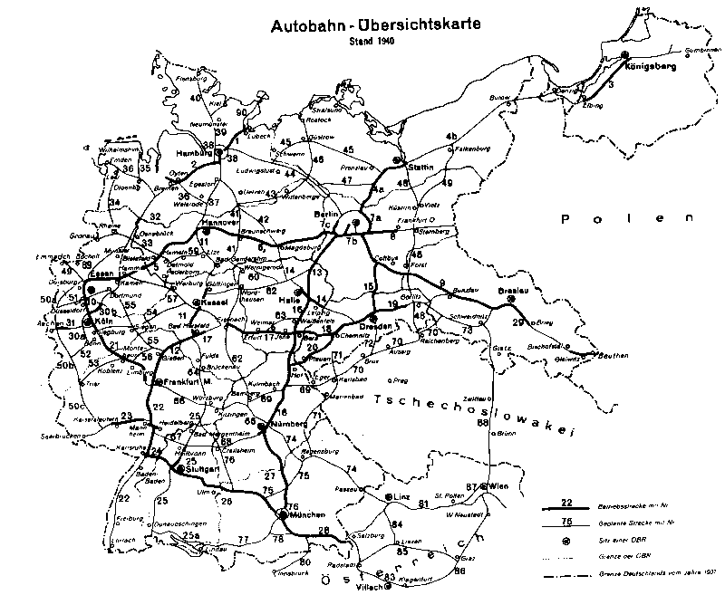
AD Bad Schwartau | AK Lübeck | AK Bargteheide | AK Hamburg-Ost | AD Hamburg-Southeast | AD Norderelbe | Mesh cross | Horster triangle | Buchholz triangle | Bremen Cross | AD Stuhr | AD Ahlhorner Heide | AK Lotte / Osnabrück | AK Münster-Süd | Kamen Cross | AK Dortmund / Unna | Westhofen Cross | AK Wuppertal-North | AK Leverkusen | AK Leverkusen-West | AK Cologne-North | AK Cologne-West | AD Erfttal | AK Bliesheim | AD Vulkaneifel | AK Wittlich | AD Moselle Valley | AD Nonnweiler | AK Saarbrücken