
Mehring (Moselle)
| coat of arms | Germany map | |
|---|---|---|

|
Coordinates: 49 ° 48 ' N , 6 ° 50' E |
|
| Basic data | ||
| State : | Rhineland-Palatinate | |
| County : | Trier-Saarburg | |
| Association municipality : | Schweich on the Roman Wine Route | |
| Height : | 130 m above sea level NHN | |
| Area : | 22.3 km 2 | |
| Residents: | 2418 (Dec. 31, 2019) | |
| Population density : | 108 inhabitants per km 2 | |
| Postal code : | 54346 | |
| Area code : | 06502 | |
| License plate : | TR, SAB | |
| Community key : | 07 2 35 083 | |
| Community structure: | 2 districts | |
| Association administration address: | Brückenstrasse 26 54338 Schweich |
|
| Website : | ||
| Local Mayor : | Jürgen Kollmann ( CDU ) | |
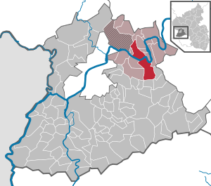
| Location of the municipality of Mehring in the district of Trier-Saarburg | ||
  |
||

Mehring an der Mosel is a municipality in the district of Trier-Saarburg in Rhineland-Palatinate . It belongs to the Verbandsgemeinde Schweich on the Roman Wine Route .
Community structure

.jpg)
On March 17, 1974, the previously independent municipality of Lörsch was incorporated.
The Mehring district also includes the residential areas Jagdhaus Ginsterheld, Mehringer Berg , Mehringer Switzerland - Landhaus Eller, Neu-Mehring and Schleicherberg .
Origin of the place name
Many old settlements on the Moselle are of Roman origin. In addition to the manifold excavation finds from this time, the names of the individual villages and localities are evidence of these roots . There were often combinations of a Roman male name and the ending iacum, which is common for Gallo-Roman settlements . With this suffix latifundia were named after their first owner in Roman Gaul . In Mehring's case, it was probably a Roman named Marinus. So the original name given to the Gallo-Roman settlement was Mariniacum . This translates as the court of Marinus. In the 8th century the place name "Marningum" appeared for the first time. Different spellings appeared in the course of the Middle Ages. The Prümer Urbar has five alone, including the first “Mehring” in 1295. This spelling only gradually established itself from the 16th century. There were deviations from this morphophonemic orthography , which is valid today, until the 19th century , such as "Mehringk" (1569) or "Mähring" (1805).
history
General
In 1563 Mehring had 99 fireplaces and in 1684 still 66. In 1787 the place had 671 inhabitants.
At the beginning of the 19th century, the Prussian mayorship of Mehring emerged from the French Mairie Mehring .
In the village fire of 1840, 156 of 222 buildings were destroyed. In the course of the reconstruction, the Neu-Mehring colony was built to the right of the Moselle .
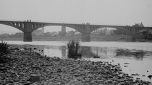
Mehring became a station of the Trier - Bullay Moselle Railway , which opened in 1903/1905 and operated until 1968. In 1903 the Moselle bridge was built and the ferry connection was discontinued.
In the course of the Moselle canalization from 1963 onwards, 73 residential buildings were demolished and by 1967 a new local area was built on the embankment.
Population development
The development of the population of Mehring in relation to today's municipality area; the values from 1871 to 1987 are based on censuses:
|
|
Graphic of the population development

|
politics
Municipal council
The local council in Mehring consists of 16 council members, who were elected in the local elections on May 26, 2019 in a personalized proportional representation, and the honorary local mayor as chairman.
The distribution of seats in the local council:
| choice | SPD | CDU | FWG * | WGR | total |
|---|---|---|---|---|---|
| 2019 | 3 | 7th | 4th | 2 | 16 seats |
| 2014 | 2 | 8th | 4th | 2 | 16 seats |
| 2009 | 2 | 7th | 5 | 2 | 16 seats |
| 2004 | 2 | 6th | 7th | 1 | 16 seats |
* FWG = Free Voting Group Mehring e. V.
Local mayor
- Jürgen Kollmann, CDU
Parish partnership
Since 1991, a community partnership with the Belgian municipality Linter .
Culture and sights
Buildings

In the district of Mehring, on Römerstrasse, there was a villa rustica that can be viewed as a reconstruction. The portico area was rebuilt over the original remains.
The Roman Qanat von Mehring (tunnel water pipe) is located on Goldkuppstrasse on the northern edge of the municipality .
In the district of Lörsch, the remains of an extensive Roman building complex were excavated, which extended for about 600 m along the banks of the Moselle.
In a vineyard wall, built-in blocks of a Roman grave monument can still be seen.
On the left of the Moselle, viticulture was specialized on the flat slopes as early as the Middle Ages, while the right side of the Moselle was more used for agriculture and cattle farming. The agricultural use brought the pastureland the name "Kühstantinopel". At the still existing ferry tower, the ferry crossed the Moselle until the new bridge ( K85 ) was built.
The Landwehr Cross from the late 19th century, a popular hiking destination, is located at the highest point of the Mehringer Moselle Mountains , the Mehringer Berg (Longen / Mehring) . The avenue of trees of the year lies between the Neumehring settlement and the core town of Mehring on Kreisstraße 85.
The former synagogue Mehring (Mosel) was built before 1883 right next to the church. It was later used as a kindergarten and library and is now a residential building.
See also: List of cultural monuments in Mehring
societies
With 450 members, which is sports club Mehring 1921 eV the largest membership organization in the town. The football A team currently plays (2017/18 season) in the Rhineland League .
According to the Register of the Local Court of Wittlich there in Mehring following registered clubs: Fishing -Club Mehring 1975 Fanfarenzug Mehring 1967 Field Archery Mehring, Förderkreis Schuki - Mehring, development association of volunteer firefighters Mehring, Förderverein SV Mehring , Gewerbeverein Mehring, men's and women's choir Mehring, MARNINGUM, us Duaref Kulturhistorischer Verein Mehring, Mountainbike Club Mehring, Reha-Sport Mehring - Association for rehabilitative gymnastics, St. Sebastianus Schützenbruderschaft 1636 Mehring, Touristikverein Mehring, Volleyball Club Butterlinge Mehring and Water Sports Club Mehring. In addition, know the winery Chapel Mehring and the winemaker dance group Mehring. The Mehring Carnival Association Oh Leit here! 1982 eV was dissolved in 2017.
Economy and Infrastructure
The offices of Raiffeisenbank Mehring-Leiwen and Sparkasse Trier are located in Mehring .
Viticulture
Mehring is significantly influenced by viticulture and with 237 hectares of vineyards, after Piesport , Zell , Leiwen , Konz and Neumagen-Dhron, it is the fifth largest wine-growing community on the Moselle . Traditionally, Riesling is mainly grown. Viticulture also forms the basis for tourism , which is also an important branch of the economy. The focus is on cycling and hiking tourism. Mehring is located on the Moselle cycle path and is connected by the Moselsteig Trail , which opened in 2014 .
Vineyards
- Mehringer Blattenberg
- Mehringer gold cup
- Mehringer Zellerberg
Major location: Sankt Michael
traffic
Mehring is located on the federal highway 1 ( Europastraße 422 ), on the federal highway 53 and on other state and district roads .
The wine route (Moselle) once led to Birkenfeld (Nahe) .
Public facilities

- Community office, tourist information, wine and local history museum
- Kindergarten, elementary school, sports field, gym
Personalities
- Peter Schroeder (1875–1935), called Peter von der Mosel , writer and local poet
- Karl Bollenrath (1911–1999), honorary citizen of the community and founder of the Mehring wine chapel
- Margret Hoffranzen, later Wilmes, Jutta Fassian, later Fassian-Emmrich, and Lena Endesfelder , German wine queens
Web links
- Mehring municipality
- Mehring on the website of the Verbandsgemeinde Schweich
- To search for cultural assets of the Mehring community in the database of cultural assets in the Trier region .
- Link catalog on Mehring at curlie.org (formerly DMOZ )
Individual evidence
- ↑ a b State Statistical Office of Rhineland-Palatinate - population status 2019, districts, municipalities, association communities ( help on this ).
- ↑ Official municipality directory (= State Statistical Office of Rhineland-Palatinate [Hrsg.]: Statistical volumes . Volume 407 ). Bad Ems February 2016, p. 171 (PDF; 2.8 MB).
- ↑ State Statistical Office Rhineland-Palatinate (ed.): Official directory of the municipalities and parts of the municipality. Status: January 2019 [ Version 2020 is available. ] . S. 120 (PDF; 3 MB).
- ↑ Joachim Hoffmann, Stefanie Scheit: The wine and local history museum Mehring. 1998.
- ↑ local community Mehring / Mosel. In: region-trier.de. edition regional GmbH & Co. KG, accessed on May 8, 2020 (private website).
- ↑ State Statistical Office Rhineland-Palatinate: My village, my city. Retrieved May 8, 2020 .
- ^ The Regional Returning Officer Rhineland-Palatinate: Local elections 2019, city and municipal council elections. Retrieved May 8, 2020 .
- ^ The State Returning Officer Rhineland-Palatinate: Local elections 2019, individual results. Retrieved May 8, 2020 .
- ↑ The partnership is a complete success. (No longer available online.) In: Trierischer Volksfreund . Archived from the original on June 20, 2016 ; accessed on May 8, 2020 (report on the 25th anniversary of the partnership).
- ^ Former synagogue Mehring. In: region-trier.de. edition regional GmbH & Co. KG, accessed on May 8, 2020 (private website).
- ^ SV Mehring. . Retrieved May 8, 2020.
- ↑ Moselsteig Stage 7. In: moselsteig.de. Retrieved May 8, 2020 .

Aach | Ayl | Baldringen | Bekond | Notification | Beuren (high forest) | Bonerath | Damflos | Detzem | Ensch | Farschweiler | Fur | Fish | Pine | Franzenheim | Freudenburg | Geisfeld | Greimerath | Grimburg | Gusenburg | Gusterath | Gutweiler | Heddert | Stalling | Herl | Hermeskeil | Hinzenburg | Hinzert-Pölert | Hockweiler | Holzerath | Hedgehog | Irsch | Kanzem | Chasuble | Kastel-Staadt | Kell am See | Kenn | Kirf | Klüsserath | Conc | Cord | Korlingen | Köwerich | Lampades | Langsur | Leiwen | Lunge | Longuich | Lorscheid | Mandern | Mannebach | Mehring | Mertesdorf | Merzkirchen | Morscheid | Naurath (Eifel) | Naurath (forest) | Neuhütten | Newel | Nittel | Upper cheap | Ockfen | Ollmuth | Onsdorf | Osburg | Palzem | Paschel | Pellingen | Pluwig | Pölich | Ralingen | Swift oath | Reinsfeld | Riol | Riveris | Saarburg | Schillings | Schleich | Schoden | Schömerich | Schondorf | Schweich | Serrig | Sommerau | Taben-Rodt | Tawern | Temmels | Thomm | Thörnich | Trassem | Trierweiler | Trittenheim | Vierherrenborn | Waldrach | Waldweiler | Wasserliesch | Wawern | Waves | Welschbillig | Wiltingen | Wincheringen | Zemmer | Zerf | Züsch