
Schoden
| coat of arms | Germany map | |
|---|---|---|

|
Coordinates: 49 ° 38 ' N , 6 ° 35' E |
|
| Basic data | ||
| State : | Rhineland-Palatinate | |
| County : | Trier-Saarburg | |
| Association municipality : | Saarburg-Kell | |
| Height : | 130 m above sea level NHN | |
| Area : | 5.14 km 2 | |
| Residents: | 686 (Dec. 31, 2019) | |
| Population density : | 133 inhabitants per km 2 | |
| Postal code : | 54441 | |
| Area code : | 06581 | |
| License plate : | TR, SAB | |
| Community key : | 07 2 35 122 | |
| LOCODE : | DE WU7 | |
| Association administration address: | Schloßberg 6 54439 Saarburg |
|
| Website : | ||
| Local Mayor : | Rudiger Hausen | |
| Location of the local community Schoden in the district of Trier-Saarburg | ||
  |
||


Schoden is a municipality in the Trier-Saarburg district in Rhineland-Palatinate . It belongs to the Saarburg-Kell association.
Geographical location
The place is located directly on the lower Saar . Viticulture is practiced on the rising slopes. To Schoden includes the abode winery Geisberg.
history
At the time of Louis the Pious in 816 the place was mentioned as Scoda and in 953 Scodam was named as the property of the Trier Abbey of St. Irminen ( Oeren ), which cultivated vines . The common name Irminerwald for the forest area above the local community still reminds of the presence of the Irminen in Schoden . The "Schodener Saarfeilser Marienberg" and the "Schodener Herrenberg" are among the most important top locations on the Saar.
On July 18, 1946, Schoden, together with 80 other municipalities in the districts of Trier and Saarburg , was annexed to the Saar area , which was separated from the rest of the French occupation zone in February 1946 and which was no longer under the Allied Control Council at the time . On June 6, 1947, this territorial outsourcing was withdrawn to 21 municipalities, so Schoden came to the 1946 newly formed state of Rhineland-Palatinate .
As part of the Saar expansion to major shipping route Schoden got into the 1970s dam . This forms a connection that can be used on foot and by bike across the Saar to the opposite town of Ayl - Biebelhausen. The weir separates the Saar Altarm from the Saar Canal. While shipping on the Saar Canal takes a shortcut to the north, the natural Saar flows in its original bed past Schoden and Wiltingen to reconnect with the Saar Canal after Kanzem .
In 2016, the local community Schoden celebrates its 1200th anniversary.
- Population development
The development of the population of Schoden, the values from 1871 to 1987 are based on censuses:
|
|
politics
Municipal council
The local council in Schoden consists of twelve council members, who in the local elections on May 26, 2019 in a majority vote were elected, and the honorary mayor as chairman.
mayor
Community leader / mayor / local mayor from 1893:
- 1893–1906 Matthias Klein - Conc
- 1906–1908 Nikolaus Loch - room
- 1908–1918 Matthias Zimmer - Benz
- 1918–1920 Peter Bach - carpenter
- 1920–1924 Matthias Scheer
- 1924–1929 Johann Klein - Müller
- 1930–1933 Nikolaus Loch - files
- 1933–1945 Johann Bidinger - room
- 1945–1946 Johann Philippi - Michels
- 1946–1947 Nikolaus Loch - Dohr
- 1947–1952 Matthias Kopp - Schwindt
- 1952–1974 Josef Martini
- 1974–1994 Alfons Zeimet
- 1994-2006 Leo Lauer
- 2006–2009 Martin Wagner
- 2009–2019 Andreas Pauly
- since 2019 Rüdiger Hausen
Economy and Infrastructure
The Saarburg transmitter is located on the highest elevation of the Schodener Geisberg ( 482 m above sea level ) , a 245-meter-high transmitter mast for Südwestrundfunk .
In addition, regional trains of the RB 71 line on the Saar route Trier - Saarbrücken of the DB Regio stop at Schoden-Ockfen stop every hour .
Viticulture
Schoden is part of the "Saar winegrowing area" in the Moselle region . The area under vines is 15 hectares, but has been declining in recent years. Almost 98% of the wine grown are white grape varieties (as of 2010).
- Vineyards
- Saarfeilser Marienberg
- Herrenberg
- Geisberg
tourism
Freetime activities:
- Hiking trail network , cycling with a direct connection to the Saar cycle path , bowling, water sports, paragliding and fishing.
Worth seeing
- Bismarck tower Schoden , the only Bismarck tower in the Trier-Saarburg district
- Catholic branch church St. Paulus and St. Maria Magdalena
- Lady Chapel
- Leisure facility on the banks of the Saar with a kiosk, mini golf course, beach volleyball court and boat dock
- Sculpture "Wave" of the sculpture arrangement " The Four Elements "
- geological and natural history trail
- photos

Bismarck Tower in Schoden

Catholic branch church St. Paulus and St. Maria Magdalena

Lady Chapel Schoden

Schoden leisure center

Sculpture "wave"
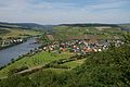
Location Schoden, view from the Bismarck tower


literature
- Ernst Wackenroder : The art monuments of the Saarburg district . (= Paul Clemen (Hrsg.): Die Kunstdenkmäler der Rheinprovinz , Volume 15, III. Department). L. Schwann, Düsseldorf 1939 (reprint from the Academic Bookshop Interbook, Trier 1982), pp. 227–228.
Web links
- Homepage of the local community Schoden
- Link catalog on Schoden at curlie.org (formerly DMOZ )
Individual evidence
- ↑ State Statistical Office of Rhineland-Palatinate - population status 2019, districts, communities, association communities ( help on this ).
- ↑ State Statistical Office Rhineland-Palatinate (ed.): Official directory of the municipalities and parts of the municipality. Status: January 2019 [ Version 2020 is available. ] . S. 125 (PDF; 3 MB).
- ^ A b State Statistical Office Rhineland-Palatinate: My village, my city. Retrieved July 26, 2019 .
- ^ The Regional Returning Officer Rhineland-Palatinate: Local elections 2019, city and municipal council elections

Aach | Ayl | Baldringen | Bekond | Notification | Beuren (high forest) | Bonerath | Damflos | Detzem | Ensch | Farschweiler | Fur | Fish | Pine | Franzenheim | Freudenburg | Geisfeld | Greimerath | Grimburg | Gusenburg | Gusterath | Gutweiler | Heddert | Stalling | Herl | Hermeskeil | Hinzenburg | Hinzert-Pölert | Hockweiler | Holzerath | Hedgehog | Irsch | Kanzem | Chasuble | Kastel-Staadt | Kell am See | Kenn | Kirf | Klüsserath | Conc | Cord | Korlingen | Köwerich | Lampades | Langsur | Leiwen | Lunge | Longuich | Lorscheid | Mandern | Mannebach | Mehring | Mertesdorf | Merzkirchen | Morscheid | Naurath (Eifel) | Naurath (forest) | Neuhütten | Newel | Nittel | Upper cheap | Ockfen | Ollmuth | Onsdorf | Osburg | Palzem | Paschel | Pellingen | Pluwig | Pölich | Ralingen | Swift oath | Reinsfeld | Riol | Riveris | Saarburg | Schillings | Schleich | Schoden | Schömerich | Schondorf | Schweich | Serrig | Sommerau | Taben-Rodt | Tawern | Temmels | Thomm | Thörnich | Trassem | Trierweiler | Trittenheim | Vierherrenborn | Waldrach | Waldweiler | Wasserliesch | Wawern | Waves | Welschbillig | Wiltingen | Wincheringen | Zemmer | Zerf | Züsch