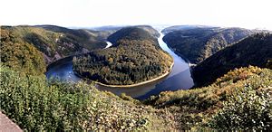
Saar cycle path
The 111 km long Saar cycle path is an international long-distance cycle path along the Saar . It leads from Sarreguemines in France via Saarbrücken , Saarlouis , Merzig , Mettlach and Saarburg to Konz at the confluence of the Saar and the Moselle .
The Saar cycle path was awarded four stars as a "quality route" by the ADFC .
Connecting cycle paths
- Glan-Blies cycle path
- Cycle path on the Saar Canal in Lorraine
- Saarland cycle route
- Hunsrück cycle path
- Moselle cycle path
See also
Individual evidence
- ↑ a b Saar-Radweg accessed on November 16, 2018
- ↑ Saar Cycle Path ( Memento from September 10, 2017 in the Internet Archive )
- ↑ Saar-Radweg - Sa (ar) genhaft !, on adfc.de, accessed on September 9, 2017.
Web links
Wikivoyage: Saar Cycle Route - travel guide
