
Homburg
| coat of arms | Germany map | |
|---|---|---|

|
Coordinates: 49 ° 19 ' N , 7 ° 20' E |
|
| Basic data | ||
| State : | Saarland | |
| County : | Saarpfalz district | |
| Height : | 233 m above sea level NHN | |
| Area : | 82.65 km 2 | |
| Residents: | 41,875 (Dec 31, 2019) | |
| Population density : | 507 inhabitants per km 2 | |
| Postal code : | 66424 | |
| Primaries : | 06841, 06848 (Einöd, Wörschweiler) |
|
| License plate : | HOM | |
| Community key : | 10 0 45 114 | |
| LOCODE : | DE HOM | |
| City structure: | 9 districts | |
City administration address : |
Am Forum 5 66424 Homburg |
|
| Website : | ||
| Lord Mayor : | Rüdiger Schneidewind ( suspended until further notice ) ( SPD ) | |
| Location of the city of Homburg in the Saarpfalz district | ||
  |
||


Homburg (in the local dialect Humborch ) is the district town of the Saarpfalz district in Saarland . The university town with 41,875 inhabitants (as of December 31, 2019) the third largest city of Saarland.
geography
Geographical location
Homburg, located in the east of the Saarland, borders on the foothills of the Palatinate Forest . The western districts of Beeden , Schwarzenbach , Wörschweiler , Schwarzenacker , Einöd and Ingweiler are located in or on the valley of the Blies . The sometimes used suffix “(Saar)” (also: “Homburg / Saar”) is a relic from the time when there were no postcodes and not an official part of the city name. It does not mean that Homburg is located on the Saar river , but is a short name for the Saar area or from 1935 for the Saarland . Until the founding of the Saar area, the common name was Homburg (Palatinate). The north-western parts of the urban area lie in the large West Palatinate moorland , which extends over 40 kilometers from Schwarzenbach to Kaiserslautern . The central part of Homburg belongs to the Homburg Basin natural area , the northern part to the Jägersburger Moor - both sub-units of the St. Ingbert-Kaiserslauter Valley . The above about 260 m above sea level. Eastern areas located near the NHN are part of the Sickinger level , a sub-unit of the Zweibrücker Westrich . The geographically lowest point of Homburg at 218 m above sea level. NHN is located at the outflow of the Blies from the Homburg urban area near Ingweiler. The highest point is at 382 m above sea level. NHN the Einöder height between Kirrberg and Einöd.
Neighboring communities
The city borders on the cities of Bexbach and Blieskastel and the municipality of Kirkel (all in Saarland ) as well as the independent city of Zweibrücken and the municipalities of Waldmohr (in the district of Kusel ), Bruchmühlbach-Miesau (in the district of Kaiserslautern ) and the municipalities of the district Südwestpfalz , Bechhofen and Käshofen (all in Rhineland-Palatinate ).
City structure
The city of Homburg consists of the inner city of Homburg and nine districts. According to the alphabet, these are Beeden , Bruchhof-Sanddorf , Einöd , Erbach , Jägersburg , Kirrberg , Reiskirchen , Schwarzenbach and Wörschweiler .
The district of Einöd is divided into Einöd, Ingweiler and Schwarzenacker . The Jägersburg district is divided into Jägersburg, Altbreitenfelderhof and Websweiler . The districts Lappentascherhof and Johannishof (colloquially Hinkelsbix ) belong to Erbach . For Doppelort Bruchhof Sand village of the district belongs acorn Scheid .
The municipalities of Einöd, Jägersburg, Kirrberg and Wörschweiler, which were independent until the regional and administrative reform, have the status of municipal districts with their own local mayors and local councils who, however, only provide advice to the city council. There are local representatives in the districts that were part of Homburg before 1974.
Population figures as of June 1, 2020:
| district | belongs to | Residents |
|---|---|---|
| Altbreitenfelderhof | Jägersburg | 124 |
| Beeden | Homburg-Mitte | 2,662 |
| Bruchhof | Homburg-Mitte | 1,857 |
| Desolate | Desolate | 2,622 |
| Erbach | Homburg-Mitte | 12,393 |
| Homburg | Homburg-Mitte | 12.005 |
| Ingweiler | Desolate | 147 |
| Jägersburg | Jägersburg | 2,685 |
| Kirrberg | Kirrberg | 2,636 |
| Lappentascher Hof | Homburg-Mitte | 202 |
| Reiskirchen | Homburg-Mitte | 1,258 |
| Sand village | Homburg-Mitte | 1,126 |
| Schwarzenacker | Desolate | 627 |
| Schwarzenbach | Homburg-Mitte | 1,889 |
| Websweiler | Jägersburg | 273 |
| Wörschweiler | Wörschweiler | 270 |
| total | 42,776 |
climate

The annual precipitation is 907 mm and is thus in the upper quarter of the values recorded by the measuring points of the German Weather Service . Over 78% of the measuring points show lower values. The driest month is April; it rains most in December. In the wettest month there is around 1.6 times more rain than in the driest month. The seasonal fluctuations in precipitation are in the middle third. In 38% of all places, the monthly precipitation fluctuates less.
history
The first settlements existed as early as Roman times in what is now the district of Schwarzenacker as an important station on two intersecting highways (Metz - Mainz and Trier - Strasbourg). In the same place there was also a settlement of the Mediomatriker . However, this reading is controversial today, especially after coin finds in the area.
In the 12th century Hohenburg was the seat of the Counts of Homburg. In 1330 they received city rights from Emperor Ludwig the Bavarian for their city at the foot of the Schlossberg, making it the second oldest city in Saarland after Saarbrücken, which received city rights nine years earlier (1321). After the death of the last Count of Homburg in 1449, the castle and town fell to the Counts of Nassau-Saarbrücken . In the second half of the 16th century they converted the castle into a renaissance castle .
During the reunification period , the French King Louis XIV had his fortress builder Vauban expand the castle and town into a strong fortress between 1679 and 1692. The basic structure of the old town dates from this time. The fortifications were finally razed in 1697 and after a reconstruction from 1705 in 1714 . From 1981 the impressive ruins on the Schlossberg were uncovered and restored. Today they are a sight on the Baroque Street Saar-Palatinate .
In 1755 Homburg came from the county of Nassau-Saarbrücken to the Duchy of Palatinate-Zweibrücken by swapping territory . Between 1778 and 1788, Duke Karl II August von Pfalz-Zweibrücken had Karlsberg Castle (hist. Spelling Carlsberg) built on Buchenberg (today's Karlsberg) near Homburg . In 1779 he moved his residence to the Karlsberg. On July 28, 1793, this castle was destroyed by French revolutionary troops.
As a result, Homburg was occupied by French troops as part of the Left Bank of the Rhine . In the Peace of Campo Formio (1797), Emperor Franz II provisionally recognized the Rhine as the future border between France and the German Empire in a secret treaty . The assignment under international law took place in the Peace of Lunéville (1801). Independently of this, the area was annexed by France and administratively incorporated into the French state in 1798.

After the regional division, which was reorganized according to the French model, Homburg became the capital of the canton of the same name in the arrondissement (sub-prefecture) of Zweibrücken in the Donnersberg department (Département du Mont-Tonnerre).
In 1816 Homburg fell to the Rhine District under the Bavarian King Maximilian I Joseph , the younger brother of Duke Karl II August.

After the districts were subdivided into land commissariats (1818), Homburg became the capital of the land commissariat of the same name . Since the cantons of the French territorial division remained in the Palatinate until 1852, Homburg was still a canton town of the canton Homburg .
At the end of 1831, the journalist and editor of the liberal-democratic newspaper Deutsche Tribüne Johann Georg August Wirth (1798–1848) moved from Munich to Homburg at the invitation of the former Homburg commissioner Philipp Jakob Siebenpfeiffer (1789–1845) , as there was a freer spirit there . The region around Homburg and the neighboring Zweibrücken was able to develop into a center of the democratic movement after the Congress of Vienna , since the Kingdom of Bavaria left the Rhine District its freedom rights introduced by the French Revolution of 1789, so u. a. also benefit from tax laws that are advantageous for the state. Wirth and Siebenpfeiffer were the initiators of the Hambach Festival ; the "Freedom Fountain" in Homburg has been a reminder of this since 1992.


In 1849 the Ludwigshafen-Homburg (1848) -Bexbach (Ludwigsbahn) railway line was completed.

Due to the territorial provisions of the Versailles Treaty (1919), Homburg belonged to the Saar area from 1920 to 1935 , which was placed under French administration for 15 years with a mandate from the League of Nations .
During the Second World War , Homburg suffered severe damage from air raids in 1944/45 . In March 1945 one of the few refineries for the production of synthetic fuels was still operating in Homburg; In addition, there were a relatively large number of German troops around the Western Wall . The Western Allies fought their way to reach the Rhine.
On March 14, 1945, the Royal Air Force (RAF) and United States Army Air Forces (USAAF) carried out the heaviest air raid on Homburg. 220 people died. The Schlossberg caves served as an air raid shelter. After the conquest of Homburg there was looting.
After the war, the city of Homburg was initially in the French occupation zone ; from 1946 to the end of 1956 it became part of the Saar Protectorate .
On March 8, 1947, under the patronage of the University of Nancy, an Institut d'Études Supérieures de Hombourg was opened, from which in 1948 the Saarland University emerged . Today the Medical Faculty and the University Hospital of Saarland University are located in Homburg .
In 1978 the old town and inner city renewal began with the creation of pedestrian zones, squares and fountains.
Incorporations
In 1913 the previously independent municipality of Beeden-Schwarzenbach was incorporated. On April 1, 1936, the municipality of Erbach-Reiskirchen was added, and on April 1, 1938, the municipality of Bruchhof-Sanddorf. In the course of the regional and administrative reform , the communities Einöd, Jägersburg, Kirrberg and Wörschweiler were incorporated on January 1, 1974.
Population development
| Population development | ||||||||||||||||||||||||||||||||||||||||||||||||||
|---|---|---|---|---|---|---|---|---|---|---|---|---|---|---|---|---|---|---|---|---|---|---|---|---|---|---|---|---|---|---|---|---|---|---|---|---|---|---|---|---|---|---|---|---|---|---|---|---|---|---|
|
|
 
|
||||||||||||||||||||||||||||||||||||||||||||||||
The population figures in 1961 and 1970 result from the censuses on June 6, 1961 and May 27, 1970. The data from 2005 onwards come from the Saarland State Statistical Office, 2005: on March 31, 2010 and 2015: on December 31.

politics
City council
After the local elections in 2019 , 51 elected citizens sit on the city council. The composition is shown in the table below, which also shows the results of the two previous elections.

| Party / list | Election 2019 | Election 2014 | Election 2009 | |||
|---|---|---|---|---|---|---|
| proportion of | Seats | proportion of | Seats | proportion of | Seats | |
| SPD | 21.8% | 11 | 36.3% | 19th | 32.7% | 17th |
| CDU | 26.5% | 14th | 31.1% | 17th | 34.6% | 19 * |
| Alliance 90 / The Greens | 18.7% | 10 | 7.4% | 4th | 5.9% | 2 * |
| The left | 8.1% | 4th | 7.3% | 4th | 10.7% | 5 |
| FWG Homburg | 8.7% | 4th | 6.9% | 3 | 8.6% | 4th |
| Alliance of Reason | - | - | 4.9% | 2 ** | - | - |
| AfD | 11.1% | 6th | 4.5% | 2 *** | - | - |
| FDP | 5.0% | 2 | 1.6% | 0 | 7.5% | 4th |
| voter turnout | 60.7% | 54.0% | 52.0% | |||
There is no fixed coalition in the Homburg city council, but mainly a factual cooperation between the parliamentary groups.
* After the local elections in 2009 the Bündnis 90 / Die Grünen parliamentary group originally had 3 seats. On December 14, 2011, a member of the Green parliamentary group announced that he had left the parliamentary group and has now joined the CDU parliamentary group. Since then, the Christian Democrats have had 19 seats.
** In October 2018, both members of the Alliance of Reason joined the CDU. Since then, the CDU had 19 members and was just as strong as the SPD.
*** In the summer of 2015, a member of the AfD left the party and parliamentary group and continued to be an independent member of the council. Thus, the AfD only had one mandate. In 2018 the resigned member gave back his mandate, so the AfD had two seats again.
Lord Mayor
Homburg has had a lord mayor since the administrative reform of 1974, previously a mayor. The elections have been direct elections since 1996 , before the city council elected the mayor.
The election with a turnout of 54 percent took place on May 25, 2014 and led to the following result, in which none of the four candidates achieved the required absolute majority:
- Rüdiger Schneidewind (SPD): 42.2%
- Peter Fuchs (CDU): 31.8%
- Marc Piazolo (non-party "Alliance of Reason", supported by the Greens): 17.8%
- Barbara Spaniol (left): 7.8%
In the runoff election on June 8, 2014 with a turnout of 41.6 percent (13,886 valid votes), Rüdiger Schneidewind emerged as the winner with 55.6 percent (7,721 votes) against Peter Fuchs 44.4% (6,165 votes).
Rüdiger Schneidewind (SPD) has been Lord Mayor of Homburg since October 1, 2014. He has been suspended from his office since March 2019 due to a conviction for infidelity in office to a suspended sentence of 15 months by the Saarbrücken regional court . Until further notice, he will be represented by Mayor Michael Forster (CDU).
coat of arms
The first seal (proof of 1699) comes from the time of the French occupation since 1680. As a coat of arms it shows a tree on the ground under the shield head with three Bourbon lilies ; From this time there is also a relief plate with the tree alone. In the town court seal dated 1700 - now under Nassau rule - there is a tree with roots in a crowned shield held by two lions.
The tree is probably rightly regarded as a tree of life and a symbol of the redesign of Homburg since 1680. As a deciduous tree, it appears when the coat of arms was approved by King Ludwig of Bavaria on August 3, 1842 .
Today's stylized tree goes back to the portrayal of Otto Hupp from 1937; a new award was not necessary.
Hupp initially left the question unanswered as to whether the tree should represent a beech or a linden tree , but then decided on a linden tree, as it was said that Homburg used to have the addition "near the linden tree".
Immediately after the merger of the city of Homburg with the former communities Einöd , Jägersburg , Kirrberg , Wörschweiler on January 1, 1974, the council of the new regional authority decided on January 18, 1974 to apply for the traditional coat of arms to be re-awarded.
On October 11, 1974, approval was finally given by the Ministry of the Interior in Saarbrücken.
The coat of arms is described as follows: "In silver on a green hill, a green linden tree with twenty-one leaves."
City and community partnerships
Homburg has partnerships between cities and municipalities with the French La Baule-Escoublac (since 1984), with the Thuringian Ilmenau (since 1989) and with the Italian Albano Laziale (since 2018).
Parties
There are city and local associations of the CDU, SPD, FWG, FDP, Bündnis 90 / Die Grünen , the Left , the Family Party and the AfD .
Economy and Infrastructure
Homburg is the location of many companies with a national and international reputation, e.g. B. Tire industry, automotive suppliers, metal production, beer brewery. With only 42,000 inhabitants, the city offers 32,000 jobs subject to social security contributions. In terms of job density, Homburg ranks 11th nationwide.
traffic

Homburg is connected to the national road network by the federal motorways 6 ( Saarbrücken - Waidhaus ) and 8 ( Perl (Mosel) - Bad Reichenhall ) as well as the federal highway 423 (from the German-French border at Mandelbachtal - Altenglan ).
The Hauptbahnhof Homburg (Saarland) was until 2007 system support for ICE trains to Frankfurt , Dresden and northern Germany and EC / IC trains to Paris , Frankfurt, Stuttgart and Salzburg . With the introduction of the continuous ICE traffic Frankfurt-Paris, Homburg lost all ICE stops except for the connection to Dresden and Stuttgart; Protests from travelers were the result.
A well-developed regional rail transport (SPNV) connects Homburg with Kaiserslautern ( Palatinate Ludwigsbahn ), Saarbrücken (also Palatinate Ludwigsbahn) and Trier ( Saar line ) as well as Neunkirchen and Illingen (Palatinate Ludwigsbahn / Fischbachtalbahn / Primstalbahn ). The RheinNeckar S-Bahn connects Homburg with the regional centers of Kaiserslautern, Ludwigshafen am Rhein , Mannheim , Heidelberg and Karlsruhe . So far, the city of Homburg has not had to pay anything for the S-Bahn.
In addition to the SaarVV tariff, the “West Palatinate / Eastern Saarland transition tariff” applies in Homburg. The tariff of the adjacent Rhein-Neckar transport association is only valid for transit. Homburg joining the VRN would cost the city around € 200,000 a year.
The Glantalbahn to Bad Münster and the Homburg – Zweibrücken railway have since been shut down . Einöd owned a train station on the Landau – Rohrbach railway line , which was closed in the 1980s, and was given a stop there again in 2009. Beeden and Schwarzenacker each had a stop on the line to Zweibrücken, Jägersburg had a train station on the Glantalbahn. From 1866 the Schwarzenacker station was a railway junction when the Würzbachbahn to Hassel opened and a year later to St. Ingbert .
State roads
In Homburg, 17 state roads run in the city area, including 6 in the 1st order and 11 in the 2nd order
Established businesses


Large companies with number of employees (as of 2008):
- Robert Bosch GmbH , three plants, including hydraulic components from Bosch Rexroth AG and testing technology from Moehwald GmbH; Injection systems for diesel engines ( common rail ) etc. a .: 5600 employees, as of Jan. 2017
- Saarland University Hospital : Healthcare, Employees: 5500
- Schaeffler Technologies AG (INA-Werke / Schaeffler): roller bearings , needle roller bearings etc .; Employees: 2400
- Michelin : truck tires , employees: 1,300
- Thyssenkrupp Gerlach GmbH : Drop forge , forged crankshafts (700, as of Jan. 2017)
- Karlsberg Brewery : Beer and mixed beer beverages, employees: 1100, 700 of them in Homburg
- Dr. Theiss Naturwaren : natural remedies and natural care products, employees: 2000, 510 of them in Homburg
- Saar-Blankstahl : Remnants of the former Neunkirchen ironworks , once the city's largest employer, now a subsidiary of Saarstahl , employees: 200
Homburg is the seat of the Kreissparkasse Saarpfalz and the Volks- und Raiffeisenbank Saarpfalz .
Government and municipal companies
In addition to the administration of the Saarpfalz district and the city itself, there are other authorities and municipal companies in the city, including the employment agency , tax office , police inspection , customs office , state building authority and the Homburg public utility .
Judicial system
In the town is the district court Homburg , which the District Court of the District Court Saarbrücken - and OLG of -Bezirk Saarland Higher Regional Court in Saarbruecken belongs. The city is also the seat of the Saarland Chamber of Notaries .
Educational institutions
The city is home to the Medical Faculty of Saarland University with the University Hospital and an affiliated school center with eleven schools for health professions. There are also five primary schools , two community schools : the Neue Sandrennbahn community school and the Robert Bosch community school as well as three high schools : Saarpfalz-Gymnasium , Gymnasium Johanneum and the Christian von Mannlich-Gymnasium . The vocational training center BBZ Homburg near the main train station consists of several vocational schools and technical colleges as well as a high school. The “State School for Physical and Motor Development - Schule am Webersberg”, founded in 1953 as the “Saarland home for the physically handicapped”, is located on the premises of the university clinic, where around 140 pupils from all over Saarland receive support in three courses.
Leisure and sports facilities
- Waldstadion Homburg
- Sports center Homburg / Erbach
- There is an 18-hole golf course on the site of the Websweilerhof .
- Koi Kombibad the Johannishof .
- Mini golf courses in Homburg and Jägersburg .
Culture and sights
Museums
- Roman museum Schwarzenacker including noble house with baroque garden and paintings by Johann Christian von Mannlich
- Jägersburg Castle and Palace Museum in the historic Gustavsburg
Buildings

Noble house

Ruins of the Hohenburg fortress, which Homburg gave its name

Ruins of the orangery of Karlsberg Palace

Gustavsburg in Jägersburg
St. Andreas in Erbach


- Hohenburg fortress ruins


- The Catholic parish church of St. Michael , built in 1836–41 in the neo-Romanesque style.
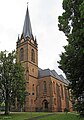
- The Protestant town church , tower built 1779–85 in Baroque style , nave built 1871–74 in neo-Gothic style.
- Schwarzenacker Roman Museum
- Palatinate sanatorium and nursing home , builder Heinrich Ullmann (1872–1953), a then modern Art Nouveau - total work of art, today the medical faculty of Saarland University .
- Schlossberg Caves : the largest red sandstone caves in Europe.
- Europe's largest red sandstone caves with mighty domed halls and kilometer-long corridors on three floors are a unique natural monument. The caves belonged to the medieval Hohenburg, which was expanded into a fortress in the early modern period and finally razed in 1714. The caves were only rediscovered in 1932. During the Second World War, they served the Homburg population as protection from air raids. Today it is possible to visit some of the caves in guided tours.
- In the Erbach district, the Catholic parish church of St. Andreas with furnishings by Wilhelm Schulte I , built 1902–1906 in neo-Gothic style.
- In the district Wörschweiler the ruins of the great medieval located monastery Wörschweiler .
- Gustavsburg in the Jägersburg district
- Ruins of Karlsberg Castle in the district of Sanddorf
nature


Homburg is located on the foothills of the Palatinate Forest and has a correspondingly large forest area of 3,549 hectares, which corresponds to 43% of the total area.
Five nature reserves have been announced in the urban area with a total area of 3,686 hectares (44.6%): the Closenbruch (between Sanddorf, Bruchhof, Erbach and Homburg), the Jägersburger Wald with the adjacent 600 hectare Königsbruch (between Erbach, Bruchhof, Eichelscheid , Vogelbach , Eichelscheiderhof , Waldmohr and Jägersburg), the Felsbachtal , the Höllengraben and the Lambsbachtal .
The 325 m high Schlossberg with walking paths, viewpoints, playground and the freely accessible castle ruins are ideal for recreation close to nature . There is also the Homburg city park, which was created in 1982, and two local recreation areas: the Beeden recreation area with Mastau and Beeder Brünnchen and the Jägersburg recreation area with historic Gustavsburg , Homburg adventure park (a high ropes course ) and arboretum . In addition, Homburg offers a wide range of hiking opportunities through the Homburg Culture Park, for example on the Karlsberg with the Karlslust or the Kirrberg circular hiking trail with the Merburgruine . Homburg is well connected to the national network of hiking trails. Homburg is on the course of the Saarland circular hiking trail , the Saar-Rhein-Main long-distance hiking trail and on the West Palatinate hiking trail number 8, the Saar-Palatinate hiking trail . The north route of the Palatinate Way of St. James also leads from Speyer through the district of Kirrberg - probably because of the pilgrimage church of the Assumption there - on to Hornbach .
Regular events
- Flea and antique market (every 1st Saturday of the month)
- Homburg Bock Beer Festival (2nd Saturday in November)
- Homburg ceramic market
- Homburg farmers market
- Homburg May Festival (3rd weekend in May)
- Jägersburger Strandfest (first weekend in July every year)
- Homburg Oktoberfest
- Homburg Nikolausmarkt (beginning of December)
- Christmas market (December)
- Master concerts and theater guest performances in the hall
Sports
- FC 08 Homburg , German amateur champion 1983, 1st Bundesliga 1986–88 and 1989/90, 2nd Bundesliga 1974–81, 1984–86, 1988/89 and 1990–95, four-time Saarland Cup winner
- Homburg hill climb
Personalities
Since 1982, the city of Homburg has been awarding the citizen medal at irregular intervals to personalities who have "made lasting contributions to the district and university town of Homburg".
Honorary citizen
In 1895 Otto von Bismarck became the first honorary citizen of the city on his 80th birthday. Since then, eleven people have been made honorary citizens, including three living.
sons and daughters of the town
Personalities who worked in Homburg
Others
.JPG)
Neukrickenbach
The residential area in the triangle between the railway line to Saarbrücken, Bexbacher Straße and Saarbrücker Straße bears the unofficial name Neukrickenbach (local: Neikriggebach ) among the people of Homburg . It was created in 1922 by the settlement of railway workers (see railway settlement ), who mainly came from Krickenbach (near Kaiserslautern ). With the onset of building construction around 1928, the quarter was opened up. The streets of the district were named after musicians, probably because the residents maintained the musical tradition from their hometown.
literature
- Dieter Blinn: Jews in Homburg, History of a Jewish World 1330-1945, Homburg 1993.
- Hans-Walter Herrmann: The Counts of Homburg, contributions to the history of an aristocratic family from Westrich, in: Communications of the Historisches Verein der Pfalz 77 (1979), pp. 27-76.
Web links
- District town Homburg
- Stadtarchiv Homburg ( Memento from August 19, 2010 in the Internet Archive ) Homburg literature (complete texts), historical postcards (scanned)
- Picture gallery with further information ( Memento from March 11, 2016 in the Internet Archive )
- Homburg through the ages in words and images ( Memento from July 3, 2013 in the Internet Archive )
- Literature about Homburg in the Saarland Bibliography
- Link catalog on Homburg at curlie.org (formerly DMOZ )
Individual evidence
- ↑ Saarland.de - Official population figures as of December 31, 2019 (PDF; 20 kB) ( help ).
- ↑ https://www.saarbruecker-zeitung.de/saarland/homburg/homburg/oberbuergermeister-ruediger-schneidewind-laesst-in-homburg-amt-ruhen_aid-36947827
- ^ Topographic map 1: 25000
- ↑ districts of Homburg on archiv.homburg.de
- ↑ a b Homburg: Data and facts, residents by district , accessed on July 6, 2020
- ↑ page 236 ( The Last Offensive , Chapter XII: The Saar Palatinate )
- ^ The last offensive , p. 262
- ^ Wilhelm Volkert (ed.): Handbook of Bavarian offices, communities and courts 1799–1980 . CH Beck, Munich 1983, ISBN 3-406-09669-7 , p. 487 .
- ↑ Erbach-Reiskirchen was incorporated into Homburg . In: Saarbrücker Zeitung of April 5, 1936, entry of the newspaper article in the Rhineland-Palatinate bibliography
- ↑ The Law no. 1383 state law standardizing and streamlining regulations (5 RBG) of 5 February 1997, Article 3 , no. 12 which replaces Regulation on the integration of the community Bruchhof sand village to the city Homburg (Saar) of 6. January 1938 .
- ^ Federal Statistical Office (ed.): Historical municipality directory for the Federal Republic of Germany. Name, border and key number changes in municipalities, counties and administrative districts from May 27, 1970 to December 31, 1982 . W. Kohlhammer, Stuttgart / Mainz 1983, ISBN 3-17-003263-1 , p. 803 .
- ↑ http://wahl.homburg.de/Stadtratswahl-2019/Erresult/index.html Website Homburg - City Council Election 2019, final result
- ^ Website Homburg , election results 2019
- ↑ City Council Election 2014 On: wahl.homburg.de, accessed on May 27, 2014
- ↑ Directory of the mayors and lords of Homburg from 1798 on the website of the city of Homburg , archive version from September 19, 2016
- ↑ Homburg: Lord Mayor Schneidewind suspended from duty In: Die Rheinpfalz , March 28, 2019
- ↑ Lord Mayor Schneidewind lets office rest In: Saarbrücker Zeitung, February 22, 2019
- ↑ Homburg gets an Italian twin town , Palatine Merkur. Retrieved October 27, 2017
- ↑ Ralph Schäfer: Homburg now also on rails: A train of the S-Bahn RheinNeckar has been called "Homburg (Saar)" since yesterday. Saarbrücker Zeitung, November 4, 2016, accessed on February 13, 2017 : "Particularly pleasing for the mayor:" Homburg has never had to make a financial contribution to the S-Bahn. ""
- ↑ Yvette Stoppiera-Wiebelt: Homburgers should benefit from cheap S-Bahn tickets! City association calls for joining the Rhein Neckar transport association (VRN). Bündnis 90 / Die Grünen OV Homburg, March 22, 2012, accessed on February 13, 2017 .
- ↑ Industrial stronghold and biosphere - the Saarpfalz district on the way to becoming a model region (PDF) in: "Economy in Saarland" 01/2008, IHK Regional, p. 17.
- ↑ Dr. Theiss group. Retrieved April 15, 2019 .
- ↑ Secondary Schools. In: homburg.de. Retrieved May 24, 2019 .
- ↑ Thorsten Wolf: Electronics make learning easier. In: Saarbrücker Zeitung, p. C2. May 25, 2013, accessed April 18, 2019 .
- ↑ Overview map of the Palatinate Way of St. James ( Memento from July 19, 2011 in the Internet Archive )
- ↑ Bearer of the citizen medal on the website of the city of Homburg, list of bearers from 1982 to 2002, accessed on October 22, 2019
- ^ Statutes on the award of the citizen medal of the district town of Homburg (Saar) (PDF), accessed on October 22, 2019
- ^ Karl Fischer: Geschichte Homburg , Chapter 8: From small town idyll to industrial town, page 125, in: Blätter zur Geschichte der Stadt Homburg , 1958. ( Page no longer available , search in web archives ), online version of the Homburg city archive
- ↑ Neukrickenbach. Information and photos on the Homburg-im-Bild website . Archived from the original on August 1, 2012 ; accessed on December 21, 2018 .
Bexbach | Blieskastel | Gersheim | Homburg | Kirkel | Mandelbachtal | St. Ingbert