
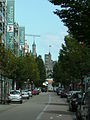
St. Ingbert
| coat of arms | Germany map | |
|---|---|---|

|
Coordinates: 49 ° 17 ' N , 7 ° 7' E |
|
| Basic data | ||
| State : | Saarland | |
| County : | Saarpfalz district | |
| Height : | 229 m above sea level NHN | |
| Area : | 49.96 km 2 | |
| Residents: | 35,427 (Dec. 31, 2019) | |
| Population density : | 709 inhabitants per km 2 | |
| Postal code : | 66386 | |
| Area code : | 06894 | |
| License plate : | ITUC | |
| Community key : | 10 0 45 117 | |
| City structure: | 5 districts | |
City administration address : |
Am Markt 12 66386 St. Ingbert |
|
| Website : | ||
| Lord Mayor : | Ulli Meyer ( CDU ) | |
| Location of the city of St. Ingbert in the Saarpfalz district | ||
  |
||


The Mittelstadt St. Ingbert ( , in the local dialect Dengmert ( )) is the fifth largest city in Saarland . The urban area includes the districts of St. Ingbert-Mitte (with Sengscheid and Schüren ), Rohrbach , Hassel , Oberwürzbach (with Reichenbrunn and Rittersmühle ) and Rentrisch .
geography


surface
The urban area with all five districts together covers an area of around 50 square kilometers. The following areas are thus allocated to the districts - listed according to population size:
- St. Ingbert-Mitte: 2473 ha
- Rohrbach: 745 ha
- Hassel: 926 ha
- Oberwürzbach: 552 ha
- Rentrisch: 208 ha
In terms of usage, the 50 km² total area of the Mittelstadt is distributed as follows:
- 22% building and open space
- 8.2% traffic area
- 14.2% agricultural land
- 52.3% forest area
Natural bases
St. Ingbert is located on the western foothills of the Palatinate Forest . Most of the urban area is characterized by natural beech forest (a little more than half of the area, see diagram) and rolling hills. The core city and the districts of Rohrbach and Rentrisch are traversed by the Rohrbach , which drains into the Saar . The brooks that flow through the districts of Reichenbrunn, Oberwürzbach and Hassel drain into the Blies .
Geologically, the city lies in the area of the Palatinate Mulde , which is formed here by the red sandstone. The less fertile soils are mainly made up of forest. A relatively species-poor, acidic beech forest would be expected as natural vegetation at most locations, a forest pattern that has also been achieved in many locations through the near-natural forest management of the last decades. An alder quarry forest should only occur in the wetlands adjacent to the stream , as can be seen in the area of the Im Glashüttental nature reserve . The nature reserves in the area of the city of St. Ingbert (Im Glashüttental / Rohrbachtal, Frohnsbachtal-Geißbachtal, Ritterstal) place such wetlands under protection. South of St. Ingbert, the Palatinate-Saarland Muschelkalkgebiet begins with the Bliesgau , which is characterized by its loamy and clayey soils and predominantly agricultural use. To the northwest of St. Ingbert, the Saarbrücker Sattel is where the carbon ( Westfalium ) begins , which was used by the St. Ingberter Grube .
In terms of its natural structure , St. Ingbert (core city and Rohrbach ) lies in the area of the St. Ingberter Senke , which forms the western end of the St. Ingbert-Kaiserslauterer Senke . The towns of Hassel , Oberwürzbach , Reichenbrunn and Sengscheid belong to the Sankt Ingbert-Kirkeler forest area . This ends with the Kahlenberg - Betzentaler Berg (Rotenkopf) - Stiefel ridge, which breaks off steeply towards the depression.
location

St. Ingbert is located on the Saarbrücken - Homburg axis , which is of central importance for the Saarland as it bundles most of the state's economic power. Internationally, St. Ingbert is on the line that connects the Paris basin with the Rhine-Main area around Frankfurt am Main . Measured according to the graticule of the earth, St. Ingbert (measurement point Engelbertskirche in the city center) is 7 ° 6 '45 "east longitude and 49 ° 16' 47" north latitude.
The middle town has seven neighboring communes. Clockwise are the Spiesen-Elversberg and Neunkirchen (Saar) ( Neunkirchen district ), Kirkel , Blieskastel and Mandelbachtal ( Saarpfalz district ), Saarbrücken and Sulzbach / Saar ( Saarbrücken regional association ).
history
The beginnings
Roman settlements in the urban area are documented from the first century AD. The chronological classification of the archaeological finds from Eichertsfels is uncertain. The first documentary mention of the place can be found on June 28, 888 in a deed of gift from King Arnulf , at that time still as Lendelfingen. Around 580 St. Ingobertus stayed in the area of today's St. Ingbert.
The place name
The name of the city goes back to the holy Ingobertus. Ingobertus or Ingbert is said to have worked as a hermit in today's urban area . According to assumptions, it could have been the area around the Heiligenbrunnen at the old cemetery. So far, however, no remains such as relics or a grave have been found; there is also no clear historical evidence of his activities in the city. Before Ingobertus settled in the area of today's St. Ingbert, he settled in Trier during the time of Bishop Magnerich in the second half of the 6th century. He knew Wendelin ("St. Wendel"), Disibod , Banto ( Franconian general) and Wulflaich ( column saint from the 6th century) personally.
After Ingobert left, a chapel was probably named after the saint, who only gave the whole place his name centuries later.
St. Ingbert was first mentioned in a document as Lendelfingen in 888 - 300 years before the name St. Ingbert even appeared. First Lendelfingen ("Lantolvinga") referred to a royal estate and a place founded by the Alemanni when the land was taken . Lendelfingen was understood to mean a district of the village in the middle of the valley. Only later did it spread to the whole place. Although the name St. Ingbert came up 300 years later, Lendelfingen was used synonymously with the new name for seven centuries. It was not until the Thirty Years' War that Lendelfingen was forgotten - along with the origins of the name “St. Ingbert ”. In 1174 the current place name was first given by “St. Turned around ”reproduced. 6 years later, St. Ingbert was named “St. Engilbertum ”mentioned in a document.
Political affiliation and ownership
In the year 960 St. Ingbert fell together with the Bliesgau to the diocese of Metz .
On July 15, 1339, St. Ingbert and Blieskastel came to the Archbishopric of Trier. Ecclesiastically, however, both remained with the diocese of Metz.
In 1475 the St. Ingberter Bann (dominion area) was determined for the first time.
In 1487 Johann von der Leyen came into possession of some rights regarding St. Ingbert through marriage.
During the plague time in the 16th century, the place belonged to Kurtrier . In the following decades until 1634 it belonged to Nassau-Saarbrücken as a pledge .
In 1634 St. Ingbert was redeemed together with Blieskastel from Nassau-Saarbrück rule by Kurtrier.
In 1793 the rule of the Counts von der Leyen came to an end. Countess Marianne fled Blieskastel. The community then received the rights that previously belonged to the counts. On September 22, 1797, the Free Republic of St. Ingbert is proclaimed, which should last eight days. Finally, in 1798, St. Ingbert was assigned to the Saar department .
Between 1814 and 1816, St. Ingbert and Blieskastel came under Bavarian-Austrian administration. In 1816 St. Ingbert was added to the Bavarian Rhine District and thus belonged to the Kingdom of Bavaria . From 1902 St. Ingbert was the seat of the district office of St. Ingbert .
With the Versailles Treaty in 1919, St. Ingbert and Homburg were ceded by the Palatinate to the newly created Saar area . This was under the administration of the League of Nations , but was economically connected to France.
In the Saar referendum on January 13, 1935, it was possible to maintain the status quo (League of Nations mandate) and incorporate the Saarland into France or Germany. 91.4% of the people of St. Ingbert were in favor of reintegration into the German Empire .
After the Second World War , Saarland became politically semi-autonomous. It was only after a new referendum in 1955 that it was incorporated into the Federal Republic of Germany in 1957 .
Economic development
In 1662 the coal mines that had fallen apart during the Thirty Years' War were put back into operation. In addition, iron ore from St. Ingbert was smelted and wood from the St. Ingbert forest was marketed in the following decades.
Industrial development slowly began in St. Ingbert in the 18th century. In 1700 the first considerations were made about the construction of an alum plant and a vitriol factory . In addition, iron ore and the forest were marketed beyond the borders of the town, as far as the Lower Rhine and Holland. A mill was built in 1725. In 1732 a lease agreement was signed between the Consortium Lehnen-Gottbill-Loth and Count Caspar von der Leyen for the construction of an iron works. In the early summer of 1733 the time had finally come, and a smelter with a smelter and hammer mill was able to start operations.
In the 1870s, coal mining was gradually opened up. In addition, the first official investigation into mining in St. Ingbert took place during this period. The idea of nationalizing the many private mines was wrestled with. This was to become a reality in 1777 when Countess Marianne von der Leyen handed over the St. Ingbert mining to the entrepreneur Johann Wolfgang Falck and all St. Ingbert mines were confiscated without compensation. The coal was transported by ship to Koblenz and Mainz .
In the same year, coke was produced by opening a soot smelter . Two years later, an attempt was made to reintroduce the “Praschenfeuerung” that had already been tried in 1773. In the same year the ruin of the ironworks became apparent, but this was taken over by the count's rent chamber (financial administration) itself.
In 1784 the Mariannentaler Glashütte was founded in St. Ingbert by Marianne von der Leyen. This glassworks received the right to operate its own coal mines. In 1786 a contract was made to found a new alum smelter.
On March 12, 1788, Countess Marianne von der Leyen issued a decree according to which it was also possible to use hard coal in the houses. The reason for the decision was the acceptance of the St. Ingberter wood. In the same year, the Protestant Philipp H. Krämer took over parts of the iron and steel works as well as the overall management of the smelter. At that time there were 18 smelters and 13 ore diggers and coal burners.
In 1804, Philipp Heinrich Krämer's widow, Sofie Krämer, bought the ironworks.
The Otto Kaiser machine factory was founded in St. Ingbert in 1846 . Machines and iron structures of all kinds were produced here, but above all it was known for its crane construction, which was discontinued in 1994.
In the 1950s, coal mining in St. Ingbert slowly came to a standstill. The pit was closed. In the 1970s, the glassworks was also closed. In St. Ingbert, this made a major structural change towards the service sector necessary.
Events of war and other disasters
In the mid-16th century (1553) that raged in St. Ingbert plague . In 1573 and 1574 the area was hit again by the plague. In 1637 St. Ingbert was completely destroyed by fire, with the exception of the church.
During the First World War , St. Ingbert was attacked several times by enemy aircraft in 1915. Some residents were killed. The memorial, erected in 1932, names the 547 Sankt Ingbertern who died in the First World War.
In 1940 the first British air raid on St. Ingbert took place. As early as 1941 there was the 100th air raid alarm. A year later, the bells of the churches were removed for war purposes. The city was bombed on May 11, June 29, July 16 and September 18, 1944, in which 21 people lost their lives and 35 homes were destroyed. Between December 8 and 17, 1944, the city was under American artillery fire.
On January 1 and 14, and on February 13 and 15, 1945 there were further bombing raids on the city. From March 5th to 7th there was artillery fire.
On March 20, 1945 troops of the 3rd US Army marched in from Ensheim, five days later the Americans were replaced by the French, who also took over the administration of St. Ingbert. In the Second World War, 1,052 residents of St. Ingbert were killed.
On July 17, 2007 the spire and the roof of the nave of the Church of St. Joseph burned down. The reconstruction lasted until 2011.
Development of the population
From 1329 the first inhabitants were named. Two years later, the first real register of residents appeared, which included 25 households.
Towards the end of the 17th century (1698) St. Ingbert had 21 households with 88 inhabitants, towards the end of the 19th century the city had around 10,000 inhabitants.
By 1923, the population grew rapidly due to the booming coal mining, iron processing and glass industries. In 1939 the population rose to 28,000 due to repatriates. As a result of the events of the Second World War, up to 40,000 people lived in the city at times.
For a few years now, St. Ingbert's population has been declining, with the population dropping from 41,000 to around 37,000. The status of a medium-sized town is not endangered by this, after the state parliament of the Saarland had already reduced the relevant limit from 40,000 to 30,000 inhabitants years ago.
Cultural and other events
Pre-Bavarian time
During the period around 1561 there were repeated disputes about the right of escort and about the St. Ingbert Forest - often between the Electors of Trier, the Dukes of Pfalz-Zweibrücken and Nassau-Saarbrücken.
Around 1564, the boundaries of the St. Ingbert ban were laid down in detail. Tilemann Stella used a map to describe the borders - especially with regard to the neighboring villages of Hassel and Rohrbach .
At the beginning of the 17th century there were frequent pasture disputes between St. Ingbert and Rohrbach.
In the 1730s, 1740s and 1750s there were forest trials in St. Ingbert between the count's treasury and the community of St. Ingbert. In the first instance, the municipality lost the supposed rights of use. This judgment was also confirmed in the second instance. In order to get through the Reich Chamber of Commerce in Wetzlar , the community had documents forged. In July 1775, the Electors of Trier intervened in the process and sided with the community. According to an expert opinion by an electoral trier forester, the forest process ended with a settlement. The result was an intervention step by Kurtrier in the process in favor of the sovereignty.
In 1739 an imperial post office was built in St. Ingbert.
In 1755 the Catholic St. Engelbert Church was completed. This gave the village, which now has 400 inhabitants, its own church. Before the masses only took place in a chapel. Originally the church should be called Ingobertuskirche. But because the existence of Ingobertus could not be regarded as certain at that time, the Engelbert compromise was agreed .
With industrial development, the first foreign miners were finally hired in 1773. In 1785 the first Protestant miners immigrated to the purely Catholic St. Ingbert. This was taken into account with the construction of the Martin Luther Church in 1858/59.
On September 18, 1789 there were uprisings in some communities in the territory of the Counts of Leyen. On October 9th, the Schmelz, the coal mines and the forest were occupied by citizens. The result was the election of new revolutionary community leaders. From December 6, 1789 to January of the following year, the imperial execution was imposed on the place. As a result, St. Ingbert was occupied by the Electoral Palatinate and Electoral Mainz troops .
In 1792, after violent tumult, a tree of freedom was placed in front of the portal of the Engelsbert Church. In 1793 the rule of the Counts von der Leyen came to an end. Countess Marianne fled Blieskastel. The community then received the rights that previously belonged to the counts. Between 1793 and 1795 the coal mines were alternately in French and German hands.

In 1801, because of the Concordat between Pope Pius VII and Napoleon , St. Ingbert was separated from the diocese of Metz and added to the diocese of Trier , which it remained until 1821. Between 1806 and 1813 Napoleon and his troops crossed the place seven times.
Bavarian period (1816-1919)
Between 1814 and 1816, St. Ingbert and Blieskastel came under Bavarian-Austrian administration. From 1816 St. Ingbert was added to the Kingdom of Bavaria . The mine was also owned by the Bavarian state.
In 1821, as a result of Bavarian rule, the parish of St. Ingbert was added to the diocese of Speyer , to which it still belongs today.

In 1829 the community of St. Ingbert was granted city rights, which, however, did not bring any major innovations, as the place had market rights before that. From 1816 until the beginning of the 20th century, St. Ingbert was under the administration of the Kingdom of Bavaria. Evidence of this are old boundary stones, the coat of arms of St. Ingbert (with Bavarian blue and silver), as well as belonging to the diocese of Speyer, which in turn is suffragan of the archdiocese of Bamberg in Bavaria .
The first street lighting was introduced in St. Ingbert in 1838, back then with the help of petroleum . In 1849 the town of Rohrbach was separated from St. Ingbert and became its own mayor's office. Later, in 1852, Oberwürzbach was also separated and incorporated into the mayor's office in Ommersheim .
Because of the mining industry and the associated immigration of many Protestants to the Catholic St. Ingbert, the building of a Protestant church had become necessary.
In 1864 the St. Ingbert volunteer fire brigade was founded, one year later the first local newspaper , and in 1888 Friedrich Dasbach founded the Westpfälzische Zeitung, which is close to the center .
Gas lighting was introduced in 1866 with the establishment of a gas works.

On June 1, 1867, the city was connected to the railway network via the Hassel - Schwarzenacker route to Homburg and on to Ludwigshafen am Rhein . Three years later the railway line towards Saarbrücken was completed. The train service from Homburg to Saarbrücken continued via Neunkirchen (Saar) .
After the Church of St. Engelbert had become too small, the foundation stone was laid in 1890 for the Church of St. Joseph, which was to be inaugurated three years later. In 1899 the Josefskirche got its first ringing with four bells, which had to be delivered due to the war in 1942 and were melted down.

On January 1, 1904, the new connecting line from St. Ingbert via Rohrbach to Hassel was completed. The direct connection between St. Ingbert and Hassel was closed because the Hassel tunnel was in danger of collapsing. On the same date, the direct route from Rohrbach via Kirkel and Limbach to Homburg went into operation.
After the First World War
In 1922 the first electric street lighting was introduced in parts of St. Ingbert, the gas lanterns remained in operation in other urban areas until the 1950s.
During the League of Nations mandate over the Saar area (1920-1935), a domain school was set up in St. Ingbert at Easter 1923 .
In 1936 Sengscheid was separated from Ensheim and St. Ingbert was added.
In St. Ingbert there were no riots against Jews on November 9, 1938 ( Reichskristallnacht ) . The synagogue , which had been in the possession of the city of St. Ingbert since October 1936, also remained intact. During the Nazi era, the Jewish community's cemetery was desecrated, the tombstones cleared and stored in a neighboring quarry. After 1945 they were put up again.
Since the Second World War
In 1953 the city of St. Ingbert donated a replacement for the bells that were lost in the war; Of the total of 21 bells, St. Joseph's Church received five (St. Theodor, St. Carolus, St. Mary, St. Joseph, Guardian Angel). These fell victim to the fire in July 2007 and were replaced in 2011. In addition to the five, two more (St. Florian, St. Ingobertus) were added by donors.

On January 1, 1974, the district of Sankt Ingbert was merged with the district of Homburg to form the Saar-Palatinate district . Homburg was designated the district town of this new district. As compensation, the city was granted the status of a medium- sized town on April 1, 1974, which granted St. Ingbert more rights than an ordinary town. Although St. Ingbert is located in the Saarpfalz district (the spelling of the district name has been slightly changed since July 10, 1989), the community supervision is not carried out by the district, but directly by the Saarland Ministry of the Interior. This special position is also made clear by the fact that St. Ingbert has its own vehicle registration district , to which the distinctive IGB was assigned.
On December 1, 2000, the spelling Sankt Ingbert was officially changed to St. Ingbert .
Since January 1, 2008, St. Ingbert has been the seat of the newly created regional administrative office responsible for the whole of the Saarland (including the Central Foreigners Authority, Central Administrative Fine Office, and community supervision). In January 2009, the new State Institute for Preventive Action (LPH) started its work at the former Mühlwald School.
Disappeared industries and economic sectors
Various branches of industry and commerce that shaped life in St. Ingbert completely disappeared in the 20th century.
Apart from a few names, a few characteristic streets remain from the former focus of the entire southwest German glass industry. On the site of the former United Vopelius and Wentzel glassworks near the autobahn, there is now a hardware store, the shape of which is reminiscent of the old glassworks.

The " Beckerturm " still reminds of the former Becker brewery , which, together with the St. Josef Church, defines the townscape above Kaiserstraße.
The Rischbach tunnel, which is accessible as a visitor mine , is still reminiscent of the former largest Bavarian coal mine in the northern part of the city, the St. Ingbert coal mine .
Territorial reform
On January 1, 1974, the previously independent municipalities of Hassel , Oberwürzbach , Rentrisch and Rohrbach were assigned to the city of St. Ingbert as part of the Saarland regional and administrative reform .
At the same time, parts of the area with then more than 800 inhabitants were reclassified to the neighboring town of Sulzbach / Saar . Since then they have belonged to the Sulzbach district of Schnappach .
economy
situation

After the traditional industry in the areas of glass, coal and steel almost no longer exists, today it is mainly companies in the high-tech and service sectors that create jobs. Important companies are Festo (2,600 employees), Voit Automotive (1,000 employees), assembly group Peter Gross (850 employees), SAP (450 employees), Wolfgang Preinfalk GmbH (200 employees), Laboratorien Dr. Latza & Partner and Drahtwerke St. Ingbert. The city is also the location for scientific institutions such as the Fraunhofer Institute for Biomedical Technology (IBMT).
A considerable amount of free commercial space is available in St. Ingbert.
Commercial areas
There are 12 business parks in St. Ingbert:

|
|
In addition, in 1994 the industrial and technology park was built in Kastanienweg, in which 13 start-ups have now rented office space under favorable conditions and over 50 jobs have been created.
St. Ingbert-Mitte
The first industrial areas were and are along Saarbrücker Strasse ("Alte Schmelz", wire works) and the mining area, which today houses small businesses. The city's first modern industrial park was created in the early 1950s in the “Pottaschwald” on an area of 20 hectares. Shortly thereafter, the nearby industrial area "Schiffelland" was created, which was previously used for agriculture and could only be acquired by the city with great difficulty. The 23 hectare industrial area Drahtwerk Nord Areal "DNA" (formerly Saarstahl Drahtwerk) has been newly developed since 2004.
Rohrbach
The largest commercial area is between St. Ingbert and Rohrbach on an area of 390,000 square meters. According to the development plan, the former site of Kléber Colombes, Reifen und Technische Gummiwaren AG, which is easily accessible, is to become an area for small and medium-sized companies. Between 2001 and 2004 in Rohrbach-Süd, Poensgen-und-Pfahler-Str. and Im Reihersbruch developed and sold around 50,000 square meters of industrial property by the Städtische Gewerbegeländeentwicklungsgesellschaft. There are now a number of local craft companies (e.g. Stalter CNC-Fertigung GmbH, Wagner & Günther Gartenbau, Hubert Niederländer Anlagenbau GmbH etc.) as well as national and international companies (e.g. iMAR Navigation GmbH, 50+ jobs) as well as service providers (e.g. unimed GmbH, 50+ jobs) and many new jobs were created. Other industrial areas are "Rohrbach-Mühlstraße" and "Rohrbach-Geistkirch" with the pneumatics manufacturer Festo as the largest company.
Hassel
There has also been a small industrial park in Hassel since 1960. It was built between the autobahn and Saarstrasse and was named "industrial area in the Stangenwald".
Oberwürzbach
The "Oberwürzbach industrial area" was created on private property in the Kesselwald and is a very small industrial area with few companies.
Transport and infrastructure
Air traffic
The international airport Saarbrücken-Ensheim is only around 10 minutes away by car , and Zweibrücken Airport is around 20 minutes away by car (scheduled and holiday flights have been discontinued since November 2014).
Transportation

There are four train stations or stops in the city: On the Mannheim – Saarbrücken railway (from west to east): Rentrisch, St. Ingbert, Rohrbach / Saar and on the Landau – Rohrbach railway : Hassel / Saar. Regional trains stop at all stations . The St. Ingbert train station itself, once an express train stop, is frequented by regional trains and regional express trains. It was put into operation in 1867 as the end point of the Würzbachbahn, which no longer exists in its former form .
Since January 1, 2007, the network-wide unique three-digit numbering has been in effect.
The public transport (LPT) supplies the Saar-mobile GmbH. Since September 2003, the responsible bus company in cooperation with the city administration has operated its own city bus routes under the name “Ingo” with normal intercity buses . This city bus concept brought about a significant improvement in public transport in the city. “Ingo” is based on three ring-shaped lines. The core of the city bus is at Rendezvous-Platz, a newly built bus stop on the site of the previous bus station, where the lines meet every 30 minutes and offer connections to each other.
Private transport
St. Ingbert is located directly on the federal highway 6 between Paris and Mannheim with the junction of Rohrbach (formerly St. Ingbert-Ost), St. Ingbert-Mitte and St. Ingbert-West (from east to west). Furthermore, the federal highway 40 runs through the city area.
Authorities and institutions
In addition to the administration of the city itself, the following other authorities are also located in the city:
- State administration office Saarland
- State Institute for Preventive Action
- Employment Agency (office)
- Tax office (branch office)
- Police inspection
- District court St. Ingbert
- Health department of the Saarpfalz district (branch)
- State Office for Cadastral, Surveying and Mapping (Cadastral Office for the Saar-Palatinate District)
- Rescue service school Saar with rescue arena
- Rohrbach road and motorway maintenance facility with traffic control center for Saarland
- Federal Agency for Technical Relief, Local Association St. Ingbert
education and Science
University
The HTW St. Ingbert campus existed from October 2014. Due to acute space problems in Saarbrücken, the Saarland University of Technology and Economics had relocated parts of economics to St. Ingbert. 400 students attended the lectures in the Karlsbergsaal in the Kohlenstraße up to the summer semester 2015.
Elementary and secondary schools
St. Ingbert is one of the most important school locations in the Saarpfalz district with a large catchment area. In addition to four elementary schools and a Montessori elementary school , the medium-sized town offers a large number of secondary schools . There is the private Catholic Albertus-Magnus-Gymnasium and the Leibniz-Gymnasium (St. Ingbert) (split into two building complexes), two community schools (of which the Ludwigschule is a partial all-day school), a private Catholic secondary school ( Albertus-Magnus-Realschule ) as well as a vocational training center ( Willi-Graf-Schule ) with a vocational high school, domestic and social care schools, commercial schools and technical and industrial schools. There is also a music school that supports the teaching offered by general schools.
Advanced training
In adults , the Urban offers adult education courses in a variety of subject areas. There is also an adult education center in the Saarpfalz district, which offers professional training in St. Ingbert. There is also the Catholic Adult Education Saarpfalz e. V. as well as the city library.
research
St. Ingbert is the seat of the Fraunhofer Institute for Biomedical Technology (IBMT).
St. Ingbert hotspot network
As part of the “Saarland Unwired” initiative of the Saarland Ministry of Economics and Deutsche Telekom AG , a hotspot network has been set up in St. Ingbert. Since July 2005, wireless internet access via WLAN has been available in large parts of the pedestrian zone .
politics
The family party that exists throughout Germany has been strongly represented in St. Ingbert since the early 1990s, which is particularly due to its founder, pediatrician Franz-Josef Breyer from St. Ingbert, who was also its national chairman from 1989 to 2006. With Roland grains was 2014-2016 again St. Ingbert National Chairman of the Family Party.
Another special feature in the St. Ingbert party spectrum is the citizen list “We for St. Ingbert” e. V., which was founded in 2013 and currently sits on the city council as a civic group “We for St. Ingbert” with a mandate holder.
City council

The following results were achieved in the last four city council elections in St. Ingbert:
| Party / nomination | Election 2019 | Election 2014 | Election 2009 | Election 2004 | ||||
|---|---|---|---|---|---|---|---|---|
| proportion of | Seats | proportion of | Seats | proportion of | Seats | proportion of | Seats | |
| CDU | 35.3% | 17th | 36.7% | 17th | 35.3% | 17th | 45.1% | 21st |
| SPD | 20.9% | 10 | 26.8% | 13 | 22.2% | 10 | 27.1% | 13 |
| Green | 12.1% | 5 | 6.6% | 3 | 7.5% | 3 | 7.6% | 3 |
| FDP | 3.6% | 1 | 3.2% | 1 | 7.4% | 3 | 4.9% | 0 |
| The left | 4.4% | 2 | 5.6% | 2 | 9.3% | 4th | - | - |
| Family party | 6.2% | 3 | 12.5% | 6th | 13.3% | 6th | 9.5% | 5 |
| AfD | 7.8% | 3 | - | - | - | - | - | - |
| “We for St. Ingbert” e. V. (WfS) | 2.8% | 1 | 5.2% | 2 | - | - | - | - |
| The Independents (UCD) | 2.9% | 1 | 3.5% | 1 (b) | - | - | - | - |
| FW St. Ingbert | 4.2% | 2 | - | - | 5.1% | 2 | - | - / 3 (a) |
| voter turnout | 66.8% | 51.9% | 54.8% | 49.5% | ||||
Committees
The city council has 45 seats and meets about six times a year.
The topics are pre-discussed in the five existing city council committees:
- Culture, Education, Social and Tourism Committee (11 members)
- Urban Development, Biosphere, Environment and Demography Committee (11 members)
- Construction and Works Committee (11 members)
- Main, Personnel and Finance Committee (11 members)
- Audit Committee (6 members)
Local council of St. Ingbert-Mitte
The St. Ingbert-Mitte local council has 15 seats. The distribution of seats in the 2019 local elections was as follows: CDU 7, SPD 3, Die Linke 1, Greens 3, FAMILIE 1.
City leaders
Until the regional and administrative reform in Saarland in 1974 , the then city of St. Ingbert was headed by honorary mayors. From 1974, full-time mayors were elected in the new medium-sized town of St. Ingbert. Until 2014, the first aldermen who bear the title of “mayor” were also appointed full-time. Since then, they have been working on a voluntary basis.
Mayor of the City of St. Ingbert 1930–1973
- Norbert Schier (1930–1945)
- Gelzleicher (1946)
- Karl Forster, CVP (1946–1948)
- Georg Bleif, CVP (1948–1956)
- Anton Saur, CVP (1956–1960)
- Bernhard Kokott, CDU (1961–1971)
- Werner Hellenthal, CDU (1971–1973)
Mayor of the Mittelstadt St. Ingbert from 1974
- 1999–2014: Rainer Hoffmann (CDU)
- 2014-2018: Pascal Rambaud (CDU)
- 2018–2019: Nadine Müller (CDU)
- since September 2019: Markus Schmitt (GREEN)
Lord Mayor of the Mittelstadt St. Ingbert
- 1974–1984: Werner Hellenthal (CDU)
- 1984-2004: Winfried Brandenburg (SPD)
- 2004–2012: Georg Jung (CDU)
- 2012–2019: Hans Wagner (independent, family party until September 2015 , started and elected as an independent candidate)
- since October 2019: Ulli Meyer (CDU)
In the runoff election for the office of Lord Mayor on June 9, 2019, challenger Ulli Meyer (CDU) prevailed against incumbent Hans Wagner (individual applicant) with 55.27% of the votes cast.
coat of arms
The coat of arms of the Mittelstadt St. Ingbert was awarded by the Minister of the Interior of Saarland on May 12, 1976. Since the town of St. Ingbert had been dissolved after the municipal reorganization and merged with four other municipalities to form the middle town of St. Ingbert, the right to the old coat of arms that had previously been used had also expired. However, the middle town was given the older coat of arms again - with a few small heraldic changes. The top of the wall is missing.
The coat of arms, which was valid until 1947, was first used on July 7, 1886 by a resolution of the city council. This was preceded by the approval of King Ludwig II of Bavaria. The Bavarian State Ministry of the Interior formulated the description of the coat of arms as follows:
“Three diagonally divided fields. In the middle part the Bavarian diamonds (silver and blue) with a striding lion in gold. In the black field, top left, a silver comb wheel with two crossed silver hammers. In the red field, at the bottom right, a miner dressed in black, the manhole hat with neck leather and silver mallets. "

In 1947 the coat of arms was overridden by the French military authorities and replaced with a new one. Since the old coat of arms had never been formally abolished, St. Ingbert had two coats of arms after 1947. The new coat of arms has been the coat of arms for the St. Ingbert-Mitte district since 1974.
The official description of the coat of arms reads:
“Shield in black and red, quartered by a continuous golden cross. In the upper right field there are two slanted silver mallets. In the upper left red field three golden lilies. In the lower right red field on a green three-mountain a silver chapel. In the lower left black field a silver gear. "
Town twinning
St. Ingbert maintains a town partnership with the French town of Saint-Herblain (since 1981), the Saxon town of Radebeul (since 1988), which was established during the GDR era, and an official "wine sponsorship" with Rhodt unter Rietburg since October 17, 1959 ". Together with the French twin town of Saint Herblain, there is a cooperation agreement with the Senegalese rural community of N'Diaganiao .
There used to be a partnership with Diedesfeld and Saarburg in Lorraine , but because of the war events they were no longer maintained. In addition, Rohrbach had a partnership with the municipality of Kahl am Main from 1964 to 1970, until there was no longer any interest in it.
Culture, society and sport
Meeting places for children and youth

The St. Ingbert youth center , or Juz for short, is one of the oldest in Germany that is self-governing. The beginnings of the sponsoring association “Jugendzentrum St. Ingbert in Selbstverwaltung e. V. ”extend into the early 1970s. The Juz has been located in the Pfarrgaß schoolhouse since 1980 .
Located at Rickertstraße 39 is the Caritas-Kinderhaus St. Ingbert, an institution for (semi) open child and youth work. The house offers all 6- to 16-year-olds a meeting point between 2 p.m. and 6 p.m. during school time for joint leisure activities or help in special situations.
societies
There are around 365 associations and club-like organizations in St. Ingbert. The offer ranges from carnival associations and church choirs to senior citizens' associations.
There are currently around 68 sports clubs in St. Ingbert that are dedicated to numerous different sports. With the support of the clubs it is possible to organize sporting events and to create a sport offer for the citizens. In November 2005, 24 St. Ingbert sports clubs founded the St. Ingbert Sports Association as an umbrella organization.
Museums
St. Ingbert Museum

The St. Ingbert Museum gave an overview of the life and work of the St. Ingbert impressionist Albert Weisgerber on 485 square meters . With over 70 paintings and many other works, the Albert Weisgerber Foundation owns a large part of his works, which can be classified between German Impressionism and the beginning Expressionism. The museum had an additional area of around 450 square meters, which was intended for temporary exhibitions, as well as other rooms. Initially in municipal hands, the St. Ingbert Museum was transferred to the Albert Weisgerber Foundation , newly established in 1991 , whose ideal and financial sponsors were the city of St. Ingbert and the Saarpfalz district . The museum was closed in 2007. The old cotton spinning mill was planned as a new museum, but the opening date was postponed indefinitely.
The St. Ingbert local history museum, which dealt with the industrial past in the city, was located in the same building. From 1991 to 2006 there was a permanent exhibition entitled “Coal - Iron - Steel”. Both museums were housed in the building of the former district office of St. Ingbert am Markt, which was built in the 1950s in the typical post-war style of the economic boom. The local history museum was closed in 2006 by order of the top administration.
Rischbachstollen visitor mine

The Rischbach tunnel is part of the former St. Ingbert hard coal mine , which closed its gates in 1959. The part that is accessible today (around 700 meters of the main tunnel plus several secondary tunnels) has been brought back to life by former miners since around 1990 . During the tour of the tunnel, the visitor gets an insight into the work and life of miners from over 100 years ago, when manual labor was still predominant and mine horses pulled the coal wagons. Visitors are allowed to operate machines themselves and work with “sticks and irons”. A functional, renovated mine locomotive has been in use since April 2009 .
Saarland Carnival Museum
The Carnival Museum was opened on August 26, 1995. It includes old hats, uniforms, costumes and medals, as well as other items from the Saarland Carnival. After moving, it moved to the innovation park at the Becker tower.
Literary life
St. Ingbert has had an active literary life for decades. Contributions to literature about and from the city were made by personalities who came from St. Ingbert or who lived there temporarily or permanently, including the dialect poets Karl August Woll , Karl Uhl , Eugen Motsch and Heinrich Kraus or the novelists Sybille Knauss and Martin Bettinger . The historian Wolfgang Krämer and the opera singer Siegmund Nimsgern also made literary contributions . Excerpts from works by 17 authors with connections to the city have been published in an anthology by Dirk Walter. The city library is dedicated to the mediation of literature in cooperation with a voluntary initiative: In the early 1980s, the cultural journalist Fred Oberhauser founded the St. Ingbert Literature Forum, which is still in existence today, successfully continued by Gerhard Sauder and today (2017) directed by Jürgen Bost . St. Ingbert is the location of several publishers, including Conte Verlag , Röhrig Universitätsverlag and Wassermann Verlag, which also have the city's authors in their programs and hold readings.
Events
St. Ingbert pan
The St. Ingbert pan has been awarded as part of the Cabaret Week competition since 1985 . The festival is one of the most important in the German-speaking area. The most prominent winners of the St. Ingbert pan are Eckart von Hirschhausen , Olaf Schubert and Bodo Wartke .
International jazz festival
The St. Ingbert International Jazz Festival has existed since 1987 and takes place annually with an international line-up in the town hall. Artists such as Ginger Baker , Nils Landgren , The Manhattan Transfer , Till Brönner , Maceo Parker , Al Di Meola and many more have performed.
Federal Festival of Young Film
The Federal Festival of Young Film is one of the largest German-speaking short film festivals for young talent. It has been taking place decentrally in St. Ingbert since 2018 and is aimed at filmmakers under the age of 29 with prizes worth 20,000 euros.
Ingobertus fair
At the beginning of October each year (always the third of October in connection with the weekend immediately preceding or following) one of the largest regional consumer fairs in southwest Germany takes place in St. Ingbert. In the two halls, in a large tent on the market square and on the adjacent outdoor area, people from St. Ingbert and companies from the surrounding area present their offers, which include the entire range of products for daily needs - goods and services. The fair is organized by the local "Association for Trade and Industry" in cooperation with the city administration. It recorded around 70,000 visitors on three days of the fair. The newly designed domed hall of the town hall has been included since 2008. The fair is accompanied by cultural and economic and political framework events.
Precious stones
On the first weekend in November of each year, a mineral, fossil, gemstone and jewelry exchange takes place in the town hall under the name “Edle Steine”. Over 70 traders, some of them international, are represented at the stock exchange, which has developed into the largest of its kind in southwest Germany for years. Over 10,000 interested parties regularly visit the event on the two weekend days.
Saar-Lor-Lux tourism exchange
In March of each year, on a weekend in the town hall, a tourist event with a supraregional character takes place, the “Saar-Lor-Lux Tourism Exchange”. The organizer is the Saarpfalz district in cooperation with the city of St. Ingbert. Numerous tourist destinations, but also individual providers from all regions of Germany and the Greater Region (Saarland, Lorraine, Luxembourg, Wallonia) are represented with their offers on the exchange. Over 10,000 visitors are regularly counted on the weekend.
theatre
In the town hall, theater performances take place at irregular intervals, between five and ten per season. Children's plays are also performed in the town hall. The organizer is the St. Ingbert Cultural Office. The theater groups that appear annually in the town hall include the “Musenbolde”, a youth theater group from the St. Ingbert parishes of Herz-Mariae and St. Hildegard.
Religions and churches

Catholic Church
The Catholic Christians belong to the diocese of Speyer , with the exception of the Catholics in the district of Rentrisch, who belong to the diocese of Trier .
St. Engelbert Church
The Catholic Church of St. Engelbert (also called "Alt Kerch", High German: "Old Church") dates from 1755 and was built by Baron Ferdinand von der Leyen and his wife. A church built in 1696 used to stand in the same place. It was surrounded by a cemetery until the 19th century. It stands with its south gable in the street from the Kaiserstraße, which has been converted into a pedestrian zone. The entrance portal, which shows two old coats of arms of the builders, is particularly famous.
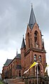
St. Joseph Church
The Catholic Church of St. Josef is a large complex in neo-Gothic forms and is located on the slope above Kaiserstraße. Together with the Beckerturm, it forms one of the city's most important landmarks . The rectory further south belongs to it.
On September 28, 1890, the foundation stone was laid for the Church of St. Joseph. It was built in red sandstone according to plans by the architect Ludwig Becker , Mainz. The building site alone cost 42,000 marks because a number of residential buildings had to be bought and demolished beforehand. The total cost was 250,000 gold marks. After the first nave beam got crooked and the second burnt down, it was finally consecrated on May 13, 1893 by Bishop Joseph Georg von Ehrler . The bells were only added in 1899. Most of the furnishings date from the time it was built.
After the Imperial Cathedral in Speyer, St. Josef is the largest church in the Speyer diocese . In a large fire on July 17, 2007, the building was so badly damaged that the roof beams burned completely and the church tower partially collapsed (the spire). All the bells jumped through the great heat. Welding was impossible, partly because the crack in the large bell (a °) was about three feet long. The cause of the fire was possibly an overloaded cable during construction work. After the population showed great sympathy and willingness to donate, the sacred building was rebuilt after it was initially unclear whether this would be feasible for static reasons. While the renovated organ was consecrated on November 1st, the church was put back into service on November 20th, 2011 after several years of renovation in a solemn pontifical mass .

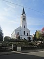
St. Hildegard Church
The Catholic Church of St. Hildegard was built in 1928/29 according to plans by the architect Albert Boßlet . The construction of the church became necessary because the space in the existing churches of St. Engelbert and St. Josef was no longer sufficient due to the strong population growth and the associated increase in the number of Catholics in St. Ingbert. The church building in a modern , simple, expressionistic design language and eye-catching exposed brickwork is considered to be the best successful church building by Bosslet.
Protestant church
The Protestant Christians St. Ingberts (except Rentrisch) belong to the Evangelical Church of the Palatinate (Protestant regional church). Rentrisch, which was incorporated in 1974, in contrast to the rest of the city, belonged to Prussia and thus to the Evangelical Church in the Rhineland (the former Rhine province). It is the other way around with the Ensheim district of Saarbrücken . It is the only one that belongs to the Palatinate Regional Church, while the rest of the city is affiliated to the Evangelical Church in the Rhineland, because Ensheim was part of the St. Ingbert district until 1973 .
Martin Luther Church and Christ Church
The Martin Luther Church , built in 1859, was the only Protestant church in the city for more than a century. It is a little higher up from Josefsthaler Strasse behind the rectory. The Kaiserstraße ( B 40 ) running in an east-west direction marks the border. The Christ Church was added in 1971 in Wolfshohlstrasse. On October 3, 2004, a bell tower was inaugurated to complete the church, the architectural design of steel and glass following the tradition of Schmelz and the glassworks. The five bells could already be heard at the 26th and 27th German Evangelical Church Congress in Hamburg in 1995 and 1997 in Leipzig .
Other Christian denominations
In addition to these two churches, there are also free churches in St. Ingbert , including a church of God , a free Christian church ( Bund Freikirchlicher Pfingstgemeinden ) and a city mission.
The New Apostolic Church is also represented in St. Ingbert.
Judaism
The former synagogue and the Jewish cemetery at the north exit of the old cemetery point to a former Jewish community in St. Ingbert.
Islam
The St. Ingbert Muslims have two mosques : St. Ingbert Mosque ( VIKZ ) and Eyüp Sultan Camii ( DİTİB ).
Attractions
Kaiserstrasse, behind the Beckerturm

Pedestrian zone

Entrance portal of St. Engelbert
Martin Luther Church
Josefskirche after fire and restoration

The devil's table

Remains of the hill fort

Old cemetery and chapel


Old enamel

The Alte Schmelz is an ironworks founded in 1733. The Alte Schmelz complex includes the ironworks itself and the workers' settlements. It is a unique testimony to social and industrial history. All developmental processes can still be traced today. It also houses the oldest surviving industrial monument in the Saarland, the Möllerhalle, which was built in 1750.
The entire complex with many historical buildings is now a listed building.
Old cotton mill
The old cotton spinning mill was founded in 1885 by Max Schuler from Wetzikon (Switzerland) as the first textile company in St. Ingbert. The manufacture of cotton spinning consisted of the production of raw, simple and fine cotton yarns and twines, which were later processed in lining weaving mills, stocking mills, sewing thread and lace factories, as well as tricot mills. The individual work steps were carried out exclusively by machine. On average, 230 employees produced 35,000 kg of yarn per month. The production buildings have been expanded, rebuilt and dismantled several times over the years. In October 1964 the production was stopped because of the bad profit situation, triggered by the duty-free import of cheap yarn from abroad. From 1964 to 1997, the former cotton mill was used by the Bundeswehr as a medical depot. There were three reserve hospital groups, each with the capacity of a 1000-bed hospital, as well as five ambulance companies (rail) .
In the summer of 1997, the Bundeswehr base in St. Ingbert was dissolved as part of the reduction in the number of troops. Werner Deller became the investor and is also the managing director of the old cotton spinning mill property management GmbH & Co KG .
Historically, the cotton mill is a document of factual functionalism in industrial architecture at the turn of the century. The building complex was listed as a historical monument in 1992. Future use should preserve the charisma of the building structure. Museum areas for the St. Ingbert Museum and rooms for cultural and artistic activities are to be created on one floor .
On the big boot
The boot

The boot on the 398 m high "Big Boot" in the Rentrisch district is a red sandstone rock that was created by the varying degrees of weathering of various sandstone packages. It probably had a cultic connection with the Spellenstein in Rentrisch. The shape of the natural monument resembles a shoe or boot standing on a base. “Boot” became the name for the entire ridge between Rentrisch and Sengscheid, on which the rock is located.

The “boot” served as a template for the creation of a figure named “ Ingo ” who, as a popular figure , advertises for St. Ingbert. The Saarbrücken graphic artist Karl Basters (1948–2008) designed the figure with the outlines of the boot and a lion's head, which was to commemorate the 104 years of St. Ingbert's time under Bavarian rule. In addition to the standard Ingo, Basters created over 50 variants of the “Ingo” over the years, such as the “Wandering Ingo” or the “Police Ingo”. In the first place, “Ingo” was issued as a sticker, but there were also a number of three-dimensional variants made of different materials.
The devil's table

The devil's table is not far from the boot rock. In contrast to this, however, it was not created by natural erosion, but in processing by human hands. According to the legend, the three-meter-high and pentagonal stone was used as a table when the giant Kreuzmann ate the captive people. It is very likely that the menhir was dedicated to cultic purposes, although it is doubtful whether this resulted in human sacrifices. In any case, this place was made for a place of sacrifice and cult for any purpose. The 364-meter-high mountain ledge rises steeply from the depths of the forest.
The Stiefler Castle
Stiefler Schloss is the common name for the remains of a medieval hilltop castle on the boot between Rentrisch and Sengscheid. Presumably it was not an aristocratic residence, but a facility for border security (Grenzgemarkung = Scheid).
According to historical and archaeological findings (excavations in 1897, 1898 and 1900), the castle was very likely built around 450 AD and was probably used to secure the border from the 10th century. Having become insignificant (since Zweibrücken and Saarbrücken came together), it probably disintegrated in the 12th century (?). The excavations revealed that the castle consisted of a rectangular stone structure measuring 8.4 m by 11.4 m. No precise statement can be made about the height. The walls consisted of massive blocks and were 1.8 m wide. With the construction in the very early Middle Ages, the Stiefeler Castle is one of the oldest castle places in Germany.
"Hansel and Gretel"

In the Sengscheider Forest, at the end of a small valley, you can find a Gallo-Roman relief carved into a boulder. It probably dates from the 2nd to 3rd century and represents a female and a male person. It is very likely that it is the Celtic deities Sucellus and Nantosuelta , who were worshiped in the open air in many places. In the vernacular the relief is called "Hansel and Gretel", more rarely also "The angels" or "Mr. Rapp and his wife".
Although the square belongs to the area of the state capital Saarbrücken, it is easy to reach from Sengscheid. "Hansel and Gretel" are located exactly in the imaginary extension of the Spellenstein - boot rock line.
The Spellenstein
The Spellenstein is a Neolithic menhir in the Rentrisch district. It stands in the front garden of the house "Am Spellenstein 12". The stone has always been at its place of installation, only the buildings have enclosed it. A legend explains its location and its appearance as "the giant whetstone" with the fact that the giant Kreuzmann, who lived on his boot, threw his whetstone after the people fleeing from him, missed his target and the stone then got stuck in the valley below. (No wonder, because people wanted to kill him.)
Beckerturm

The Beckerturm , the former brewhouse of the Becker brewery, was built between 1925 and 1931 according to plans by government master builder Hans Herkommer (Stuttgart). Herkommer was known as the architect and builder of numerous Catholic churches in the 1920s. The concrete tower, along with the “boot”, became the symbol of the middle town of St. Ingbert in today's Saarpfalz district . The 42 meter high building, which houses the machines, apparatus and containers for the production process on nine floors, as well as a “brewing room” on the top floor, is a listed building.
Today there is an innovation and technology park on the site. The brew kettles in the Beckerturm have been preserved.
In the city signet of the city of St. Ingbert, the stylized Beckerturm is included as a third element alongside the Engelberts and Josefskirche . Since 2009, with the recognition of the Bliesgau Biosphere Reserve, half an arc segment has been added.
Wallburg
The Wallburg is located on the Mittleren Kopf between Rothenkopf and Hochscheid. It is a somewhat preserved Celtic refuge. The entire mountain is surrounded by an artificial stone wall, with traces of a ditch still visible.
Old cemetery and chapel

The old cemetery was laid out in 1820 and has a number of remarkable grave monuments of important St. Ingbert citizens that date back to 1820. Also worth seeing is the chapel built in 1740, which was expanded in 1857. Behind the old cemetery is the Jewish cemetery , which was laid out in 1886 and contains around 30 grave monuments.

Others
Due to the political peculiarity of Mittelstadt , St. Ingbert, although located in the Saarpfalz district and represented by its district administrator in Homburg , does not have the license plate "HOM", but "IGB". It is one of the rarer currently assigned license plates in Germany.
Since May 10th, 2008 an ICE multiple unit named “St. Ingbert ”through the Federal Republic and neighboring countries. On that day he was solemnly baptized in his sponsored city. On July 9, 2008, this train was involved in the train accident in Cologne alongside the ICE Wolfsburg.
Personalities
Honorary citizen
Sons and daughters of the city and other personalities
literature
- Sigrid Barmbold and Michael Staudt: The red ones in the black corner. The beginnings of social democracy in St. Ingbert 1889–1919 . St. Ingbert 1991.
- Winfried Brandenburg and others: 175 years of the city of St. Ingbert - the last 25 years , Westpfälzische Verlagsdruckerei, St. Ingbert 2004, ISBN 3-9807001-4-3 .
- Markus Gestier: The beginning of political life in St. Ingbert after the end of the Second World War . In: "Journal for the history of the Saar region" . 36 (1988).
- Werner Hellenthal (Ed.): 150 Years of the City of St. Ingbert (1829–1979). A commemorative publication on the occasion of the 150th birthday of St. Ingbert's city development . City administration St. Ingbert, St. Ingbert 1979.
- Herbert Kneib: 75 years of FC Viktoria e. V. 09 St. Ingbert. Festschrift for the 75th anniversary of the association. St. Ingbert 1984.
- Wolfgang Krämer : History of the city of St. Ingbert. From the beginning to the end of the Second World War. A local history based on archival sources. 2nd edition (completely revised and significantly supplemented). Self-published by the city of St. Ingbert, St. Ingbert 1955, 2 volumes.
- Hans-Werner Krick (Ed.): Saarpfalz mine site, the overlooked Saar area (contributions to regional history, special issue 1995), St. Ingbert 1995.
- St. Ingbert. Photographs by Manfred Holz. Texts by Christel and Günter Reitz. Röhrig University Press, St. Ingbert 2016. ISBN 978-3-86110-617-3 . [Photo book with historical and geographical explanations]
- Gudrun Stark, Hans-Werner Krick: St. Ingbert - Old pictures tell Sutton-Verlag, Erfurt 1998, ISBN 3-89702-071-8 .
- Erwin Stein (Ed.): The book of the city of St. Ingbert , Deutscher Kommunal-Verlag, Berlin-Friedenau 1933.
- Thomas Strauch: Stone contemporary witnesses of a 4000 year old cultural history. In the yearbook for the miners' calendar 2006, pages 147 to 153. Published by Deutsche Steinkohle AG.
- Dirk Walter (Ed.): St. Ingbert - Literature of a City. Highlights from Karl August Woll to Martin Bettinger. Röhrig Universitätsverlag , St. Ingbert 2017, ISBN 978-3-86110-637-1 .
- Petra Weber: Traces of the past: two historical nature trails in the district of St. Ingbert Westpfälzische Verlags-Druckerei, St. Ingbert 1986.
- Dieter Wirth, Günther Ricke: Greetings from St. Ingbert. A tour through and around the old Dengmert on the basis of old postcards, on the occasion of the 1100 year celebration of the first documentary mention of St. Ingbert Demetz, St. Ingbert 1988.
Web links
- Literature on St. Ingbert in the Saarland Bibliography
- Middle town St. Ingbert
- On the history of St. Ingbert ( Memento from June 13, 2006 in the Internet Archive )
- Link catalog on St. Ingbert at curlie.org (formerly DMOZ )
Individual evidence
- ↑ Saarland.de - Official population figures as of December 31, 2019 (PDF; 20 kB) ( help ).
- ↑ Municipalities in Germany by population on December 31, 2011 based on the 2011 census , Federal Statistical Office (XLS file; 2.0 MB).
- ↑ Peter Rothe: The geology of Germany. 48 Portraits of Landscapes, Wissenschaftliche Buchgesellschaft, Darmstadt 2005, p. 137 ff.
- ^ Fritz Runge: The Plant Societies of Central Europe , Aschendorff Verlag, Münster 1994, p. 273 f.
- ↑ Archive link ( Memento of the original from July 19, 2011 in the Internet Archive ) Info: The archive link was inserted automatically and has not yet been checked. Please check the original and archive link according to the instructions and then remove this notice. .
- ↑ Rothe, Fig. 104.
- ↑ Map of the natural structure of the Saarland ( page no longer available , search in web archives ) Info: The link was automatically marked as defective. Please check the link according to the instructions and then remove this notice. PDF file accessed October 16, 2011.
- ↑ Arnold Ilgemann: "French schools" - The French Domanialschulen in the League of Nations. (PDF) MELUSINE - Literary Society Saar-Lor-Lux-Elsass eV , June 22, 1993, accessed on September 27, 2019 (lecture manuscript).
- ↑ Archive link ( Memento of the original from July 17, 2009 in the Internet Archive ) Info: The archive link was inserted automatically and has not yet been checked. Please check the original and archive link according to the instructions and then remove this notice.
- ↑ www.alemannia-judaica.de
- ↑ Fire of the St. Josef Church in St. Ingbert ( page no longer available , search in web archives ) Info: The link was automatically marked as defective. Please check the link according to the instructions and then remove this notice.
- ↑ History of St. Ingbert (PDF; 59 kB).
- ^ StBA: Changes in the municipalities in Germany, see 2000
- ↑ Wolfgang Krämer: History of the city of St. Ingbert . Self-published by the city of St. Ingbert, 1955, vol. II, p. 237.
- ↑ New Structure Act - NGG of December 19, 1973, Section 14, published in the Saarland Official Gazette 1973, No. 48, p. 855 (PDF page 26; 499 kB).
- ↑ a b Federal Statistical Office (ed.): Historical municipality register for the Federal Republic of Germany. Name, border and key number changes in municipalities, counties and administrative districts from May 27, 1970 to December 31, 1982 . W. Kohlhammer, Stuttgart / Mainz 1983, ISBN 3-17-003263-1 , p. 808 .
- ↑ Primary schools in the Saarpfalz district, as of 2011, accessed on August 14, 2011 ( Memento of the original from February 17, 2013 in the Internet Archive ) Info: The archive link was inserted automatically and has not yet been checked. Please check the original and archive link according to the instructions and then remove this notice.
- ↑ New rooms, new teachers and even a new school ( page no longer available , search in web archives ) Info: The link was automatically marked as defective. Please check the link according to the instructions and then remove this notice. , Article in the Palatinate Merkur of August 16, 2012.
- ↑ BBZ, accessed on August 14, 2011
- ^ Family Party Germany - Federal Executive , website of the Family Party Germany. Retrieved May 31, 2016.
- ↑ st-ingbert.de - City council election of the city of St. Ingbert on May 26th, 2019 - Final result .
- ↑ 2014 election results ( Memento of the original from May 29, 2014 in the Internet Archive ) Info: The archive link was inserted automatically and has not yet been checked. Please check the original and archive link according to the instructions and then remove this notice.
- ^ History. Free Voters St. Ingbert, accessed April 22, 2014 .
- ↑ sanktingbert.de
- ↑ Rischbachstollen visitor mine
- ↑ literaturland-saar.de
- ↑ Dirk Walter (Ed.): St. Ingbert - Literature of a City. Highlights from Karl August Woll to Martin Bettinger. Röhrig University Press, St. Ingbert 2017.
- ↑ ingoBerta - St. Ingberter Blätter, edition 35, 8th volume, autumn 2007, p. 6.
- ↑ What is meant is: The largest, purely Catholic Church; the Otterberg Abbey Church ( Simultankirche ) is larger.
- ↑ History of the parish of St. Hildegard ( Memento of the original from April 7, 2014 in the Internet Archive ) Info: The archive link was inserted automatically and has not yet been checked. Please check the original and archive link according to the instructions and then remove this notice. Information on the website of the parish of St. Hildegard, accessed on June 10, 2012.
- ^ Church of God St. Ingbert. Retrieved February 22, 2018 .
- ↑ Free Christian Community of St. Ingbert. Retrieved February 22, 2018 .
- ↑ stadtmission-sankt-ingbert.de. Retrieved February 9, 2019 .
- ↑ Report ( Memento of the original from July 16, 2009 in the Internet Archive ) Info: The archive link was automatically inserted and not yet checked. Please check the original and archive link according to the instructions and then remove this notice. on www.rp-online.de on July 10, 2008
Bexbach | Blieskastel | Gersheim | Homburg | Kirkel | Mandelbachtal | St. Ingbert