
Bliesgau


The Bliesgau is a region and a natural space in the Saarland on the Blies river , a right tributary of the Saar , and was a medieval county . The Bliesgau is a landscape with rolling hills, wide orchards and is characterized by the shell limestone soil . It is commonly referred to as the "Tuscany of the Saarland".
The Bliesgau biosphere reserve , which includes other natural areas such as parts of the Homburg Basin , the Sankt Ingbert-Kirkeler forest area and the St. Ingberter Senke , but also leaves out parts of the Bliesgau natural area, must be distinguished from the more geologically delimited landscape , traditionally called Bliesgau.
location
The natural area Bliesgau, which is sometimes also called Saar-Blies-Gau, forms a separate main unit in the manual of the natural spatial structure of Germany (consecutive numbering: 181) within the Palatinate-Saarland muschelkalk area ( greater region 3rd order ), which in turn forms part of the northern French layered plain ( Greater region 2nd order) belongs. It is located southeast of Saarbrücken and includes the area of the city of Blieskastel and the two communities of Gersheim and Mandelbachtal .
In the northeast, the Bliesgau is bounded by the Homburg Basin and begins at Ingweiler in the north . From there it stretches east from Webenheim , Mimbach and Böckweiler to Peppenkum , with Altheim being part of the Zweibrücker hill country . In the south it continues into France to the south of Gros-Réderching and Oermingen . It continues from Saargemünd (French: Sarreguemines) east of the Saar past Kleinblittersdorf to Fechingen . The Middle Saar Valley joins to the west and the Saarbrücken-Kirkeler Forest to the north . From Bischmisheim the Bliesgau includes the towns of Ensheim , Heckendalheim , Aßweiler and Biesingen to the east and turns northeast to Blieskastel via Bierbach an der Blies to almost Wörschweiler .
The Bliesgau includes the natural spaces
- 181.0 Vorderer Bliesgau
- 181.00 Saarbach-Woogbach-Grounds (Bischmisheimer Riedel)
- 181.01 Ommersheim limestone slab
- 181.1 Bliesgau plateaus
- 181.10 Saar-Blies plateau
- 181.11 Kahlenberg plateau
- 181.2 Hinterer Bliesgau
- 181.20 Middle Bickenalbtal
- 181.21 Schloßhübel
- 181.3 Lower Bliestal
- 181.30 Blieskasteler Bliestal
- 181,300 Ingweiler valley widening
- 181.301 Blieskasteler valley funnel
- 181.31 Gersheimer Bliestal
- 181.32 Bliesransbacher loops
- 181.30 Blieskasteler Bliestal
- 181.4 Saargemünder Saar Valley
- 181.40 Sarreguemines Basin
The highest elevation of the Bliesgau is 401.1 m above sea level. NN the Great Kahlenberg near Breitfurt , on which the ruins of the Alexanderturm observation tower stand. Its lowest point is 194 m above sea level. NN near Welferding . It is drained by the Blies and in the western part by the Saarbach .
history

prehistory
The oldest traces of settlement date from the Middle Stone Age . The Gollenstein , a 4000 year old menhir, is well known .
There are many archaeological finds, especially from the late Bronze Age and the subsequent Iron Age. In Rubenheim (district of Gersheim ) and Wolfersheim (district of Blieskastel ) a large grave mound field was discovered. In Reinheim (district of Gersheim) 1954 was Celtic princesses grave found. Today it is part of the European Culture Park Bliesbruck-Reinheim . In this complex there are also remains of a Gallo-Roman settlement.
A compact area of row graves marks the core of the early medieval Bliesgau in the 6th and 7th centuries.
Medieval county

In the Franconian Empire, the ruling district called Bliesgau comprised the entire eastern part of today's Saarland and parts of the western Palatinate. Medieval names for this Bliesgau were Bliesahgouwe , Blesitchowa , pagus Blesinsis , pagus Blesiacus, pagus Bliesichgoue , Blesigowe .
The locations of the 8th to 11th centuries spread over the entire catchment area of the Blies. The places mentioned are Behren (near Forbach) , Bitsch , Bischmisheim , Ernstweiler , Eschringen , Habkirchen , Hornbach , Illingen , Kleinrosseln , Medelsheim , Mimbach , Neumünster , Niederlinxweiler , Ratzweiler , Rimlingen , St. Arnual (Saarbrücken), Schiffweiler and Walsheim . In the east, the Franconian Bliesgau bordered on the Speyergau and the Wormsgau, in the west on the Saargau.
1046 Habkirchen is documented as the seat of the Gaugrafschaft, which included the Bliesgau. After 1100 the name fell out of use, only to revive in scholarly literature from the early 18th century. The following are attested as counts:
- Erenfried, 888 Graf im Bliesgau, 895 Graf im Scarponagau , attested until 904
- Odaker, 893 Graf im Bliesgau, 901–902 Graf im Ardennengau
- Hartung, 960 Graf im Bliesgau
- Folmar I, 982 Graf im Bliesgau
- his son Folmar II, († 1026 or later), founder of St. Rémy in Lunéville, Count in Bliesgau
- his great-grandson Gottfried III, Count vom Bliesgau 1075/98
- his descendants called themselves Counts von Blieskastel
Medieval churches
As the mother church for part of the Bliesgau, the parish church of St. Martin in Habkirchen was mentioned in writing as early as 819. The medieval settlement of the Bliesgau is further documented by Romanesque round towers in Bebelsheim , Erfweiler and Reinheim . The churches are no longer preserved in their original form. The Stephanuskirche in Böckweiler in its present form dates from the 11th century.
Farmhouse and the village

Where the villages still show the original development with farmhouses, one often finds narrowly built-up streets in which the Einfirsthöfe are closely lined up. These are mostly " broadly structured single houses " (W. HABICHT) with a steep roof, the wide eaves facing the street. The wide gate that leads into the threshing floor is usually between the living area and the stable area (“Mittertennhaus”). Ellenberg explains the type of house and the close arrangement with the real estate division that used to be common in Bliesgau .
Biosphere reserve

On May 26, 2009, large parts of the Bliesgau and adjacent landscapes were recognized by UNESCO as a German biosphere reserve . All the communities in the Bliesgau had campaigned for it. In May 2001, the Friends of the Biosphere Region Bliesgau e. V. , which was followed in 2006 by the merger of the municipalities of Blieskastel, Mandelbachtal, Gersheim, Kleinblittersdorf, Kirkel, Homburg and St. Ingbert to form the Biosphere Reserve Bliesgau Association . The Saarpfalz district and Saarland are also members of this association.
nature and environment

The Bliesgau is characterized by a characteristic natural landscape, which is made up of expansive orchards, species-rich poor meadow types, extensive beech forests and a floodplain landscape criss-crossed by the strongly meandering Blies . A special feature of the Bliesgau is the variety of its landscape types with the interlocking of different large and small habitats. The landscape is characterized by sweeping rolling hills, it is characterized by thousands of years of human use and, as a cultural landscape, represents the habitat for numerous rare animal and plant species. The Bliesgau has the greatest density of threatened species and habitat types in southwest Germany.
Around 80 percent of the total occurrence of little owls in the Saarland , which are endangered in Germany, can be found in the Bliesgau . One of the largest populations of the scabiosa piebald moth is a rarity , and almost half of the orchid species occurring in Germany can be found on the limestone soils . One of the largest orchid meadows is located in the district of Gersheim. Beaver families live in the alluvial forests of the Blies and on some of the steep slopes of the Blies you can discover the kingfisher's breeding caves . At the Höllengraben nature reserve there is a herd of Heck cattle , water buffalo and Konik wild horses , a white stork nest and populations of gray herons , wild ducks , field geese and other rare animal species. Other white stork nests can be found at the fisherman's hut in Beeden, in Ingweiler an der Blies and in Webenheim.
Grazing by cattle, sheep and goats plays a special role in the maintenance and care of the Bliesgau cultural landscape. Extensive grazing ensures the preservation of the natural features of the landscape and the basis of life for threatened animal and plant species. By using breeds of domestic animals that are threatened with extinction ( Thuringian forest goats, etc.), the Saar Naturland Foundation makes another contribution to species conservation in the Bliesgau.
The concerns of ecology and the principles of sustainability has Spohns House prescribed in Gersheim. The ecological education center with adjoining school camp provides a variety of education for sustainable development (ESD), one of the most important goals of UNESCO . Spohns Haus was awarded the corresponding seal of approval from UNESCO for the fourth time ( World Decade of "Education for Sustainable Development" ).
Nature reserves
For the natural area Bliesgau several nature reserves are reported. Biotope types that are particularly worthy of protection include: semi-dry limestone lawns, warmth-loving bushes, sage oat meadows and orchid-beech forest.
Regional principle and tourism
The Bliesgau Biosphere Reserve Association has also committed itself to the principles of sustainability and regional product marketing . His endeavors aim to create economic added value for the region in the handicraft, agricultural and tourist service sectors. Numerous companies sell their products under their own joint label both in the region (“From the region for the region”) and across the region.
In terms of tourism, the Bliesgau has dedicated itself to soft tourism . An excessive tourist infrastructure was and will not be used. Natural monuments and structures that have evolved over time are advertised (see tourist destinations ). The focus in the tourist area is on hiking and biking , nature and cultural experiences and culinary offers. Influences from neighboring France have developed a gastronomic culture in the Bliesgau over the decades that can be counted among the top performances in the German-French-speaking area. The “Bliesgau Lamb Week” is an event that has now prospered across the region, while top chefs from the Bliesgau, including star chefs, offer dishes from regional lambs. The project is accompanied by art exhibitions and aims to bring art and gastronomy together.

From the Bliesgau as a starting point, numerous interesting tourist destinations in the neighboring areas of the greater Saar-Lor-Lux region can be reached in day trips.
Way of St. James
The Hornbach - Metz section of the traditional Way of St. James leads through the Bliesgau on two alternative routes. The southern one leads from Hornbach via the Wintringer Chapel and the French town of Sarreguemines in the direction of Saint-Avold , the northern one via Blieskastel, Gersheim and Saarbrücken into Forbach in France . Both routes meet again southwest of Forbach.
Tourist destinations in the Bliesgau
- Gollenstein near Blieskastel
- European Culture Park Bliesbruck-Reinheim (Celto-Roman settlement with cross-border archaeological excavations)
- Baroque old town of Blieskastel
- Historic hamlet of Graefinthal with monastery (re-established in 1993), cultural center Haus Wulfinghoff, natural stage, hotel, gastronomy in the municipality of Mandelbachtal
- Würzbacher Weiher in Niederwürzbach
- Ruins of the Alexanderturm observation tower on the Großer Kahlenberg near Breitfurt
- Höllengraben nature reserve near Beeden with rare animal species.
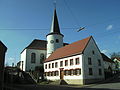
Photo gallery

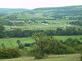
Landscape in the Bliesgau near Böckweiler
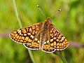
Scabiosa butterfly

Orchid meadow near Gersheim
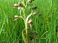
Warm, dry lime grass is the preferred location for the Bocks-Riemenzunge ( Himantoglossum hircinum )

Spohns Haus ecological education center

Lochfeld House with Bliesgaulandschaft

Landscape between Blickweiler and Wolfersheim

View from Hölschberg near Biesingen into the Bliesgau
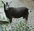
Thuringian forest goat in Bliesgau
Celto-Roman excavation site in Reinheim
St. Markus Church (Reinheim)

Church with round tower in Bebelsheim

Orangery (remains of the original palace complex) in Blieskastel


Personalities
- Ingobertus , namesake of St. Ingbert
- Wendalinus , namesake of St. Wendel
- Pirminius , namesake of Pirmasens
- Marianne von der Leyen (1745–1804), regent in Blieskastel 1775–1793
- Joseph Cardinal Wendel (1901–1960), Archbishop of Munich 1952–1960
- Andreas Hamm (1824–1894), bell founder and founder of Heidelberger Druckmaschinen
See also
literature
- Andreas Stinsky: The Bliesgau. Nature - people - history . Nünnerich-Asmus-Verlag, Mainz 2020, ISBN 978-3-96176-106-7
- Dieter Dorda / Olaf Kühne / Volker Wild (eds.): The Bliesgau. Nature and landscape in the southeastern Saarland . Institute for Regional Studies in Saarland, Saarbrücken 2006, ISBN 978-3-92387-742-3
- Fascination Bliesgau. Photos and poetry. Photographs by Karlheinz Schinder and Richard Schorn. Poetry by Uta Abel. Imprint Knischetzky im Röhrig Universitätsverlag , St. Ingbert 2017. ISBN 978-3-96227-000-1 .
- Manuela Kerchner: Vegetation studies of hay meadows in Saar-Bliesgau. 1999.
- Simone Jung: The future development of the German-French border area Bliesgau-Südwestpfalz-Pays de Bitche: considerations based on the European Spatial Development Concept (ESDP). [Diploma thesis Univ. Kaiserslautern]. Kaiserslautern 2001. (West Palatinate Information 108)
- Michael H. Schmitt: The Blies: designer of a landscape . Gollenstein Verlag, Blieskastel 2005, ISBN 3-935731-79-5 .
- Dieter Dorda, Olaf Kühne, Volker Wild (eds.): The Bliesgau: Nature and landscape in the southeastern Saarland (= publications of the Institute for Regional Studies in Saarland . Volume 42 ). Saarbrücken 2006, ISBN 978-3-923877-42-3 , pp. 303 .
- Peter Michael Lupp: Model for the design of surface coverings on paths used for agriculture, forestry and tourism in the Bliesgau biosphere reserve. A contribution to the careful valorization of a specific cultural landscape. Biosphere Purpose Association Bliesgau, Blieskastel 2009, ISBN 978-3-923405-33-6 .
Web links
- The Bliesgau
- Literature about the Bliesgau in the Saarland Bibliography
- Biosphere Purpose Association Bliesgau
- Friends of the Bliesgau Biosphere Region e. V.
- Hikes in the Bliesgau
Individual evidence
- ↑ Kerstin Joost-Schäfe: Through the "Tuscany of the Saarland" In: Saarbrücker Zeitung of May 18, 2010, page B3, accessed on February 28, 2011
- ↑ Map of the Bliesgau Biosphere Reserve , accessed on October 5, 2011.
- ↑ see article North of France layer level country and article list of natural spatial units in Saarland
- ↑ Schneider / Werle systems (sheets Saarbrücken and Trier / Mettendorf) vs tassels on one card (PDF, 2.0 MB) - in both demarcations, the Bliesgau includes all codes starting with "181".
- ↑ Helga Schneider: Geographical land survey: The natural space units on sheet 159 Saarbrücken. Federal Institute for Regional Studies, Bad Godesberg 1972. → Online map (PDF, 4.3 MB)
- ↑ Gerhard Köbler : Historical Lexicon of the German Lands: the German territories from the Middle Ages to the present . In: Beck Historical Library . 7th edition. CH Beck, Munich 2007, ISBN 978-3-406-54986-1 ( google.de ).
- ↑ Handbook of Historic Places. Rhineland-Palatinate. Saarland, Kröner 274, Stuttgart 1988, map p. 518
- ^ Roland WL Puhl: The districts and counties of the early Middle Ages in the Saar-Mosel area , Diss., Saarbrücken 1999, pp. 120–122. ISBN 3-930843-48-X
- ↑ COUNT of BLIESGAU, COUNT of BLIESCASTEL, COUNT of HÜNEBURG. Foundation for Medieval Genealogy, accessed September 15, 2016.
- ↑ Heinz Ellenberg : Farmhouse and Landscape in Ecological and Historical View , Ulmer, Stuttgart 1990, p. 442 ff
- ↑ 22 New Sites Join the UNESCO's World Network of Biosphere Reserves. (English) information site to the 22 new biosphere reserves on the website of UNESCO, on 26 May, 2009.
- ↑ “Nature as a matter of honor - Volunteers in parks”: The Bliesgau biosphere reserve is starting the next hands-on action in the orchard meadow. Press release of the Bliesgau biosphere reserve of October 10, 2011
- ^ Another Unesco award for Spohn's house . In: Saarbrücker Zeitung, St. Ingbert edition, March 8, 2007.
- ↑ saarpfalz-kreis.de ( memento from September 24, 2015 in the Internet Archive ), accessed on May 2, 2012.
- ↑ Homepage Saarpfalz-Kreis ( page no longer available , search in web archives ) Info: The link was automatically marked as defective. Please check the link according to the instructions and then remove this notice.
- ↑ Gallery k4 (Saarbrücken) exhibition Bliesgau Lamb week