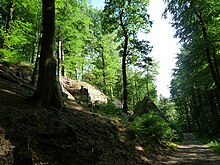
Sankt Ingbert-Kirkeler forest area

The Sankt Ingbert-Kirkeler forest area is a natural area in the southern Saarland. It extends in the Saar Palatinate district from the St. Ingbert district of Rentrisch in the west, over St. Ingbert and over Kirkel to Wörschweiler in the east. The Sankt Ingbert-Kirkeler forest area , together with the St. Johann forest and, in a broader sense, the Scheidter Berg form the Saarbrücken-Kirkeler forest and thus belongs to the Palatinate-Saarland muschelkalk area .
It is a hilly landscape with a maximum of around 400 m above sea level. NN on red sandstone , the potential natural vegetation of which for the most part would be an acidic, species-poor beech forest . The near-natural forest management of the last decades has ensured that the coniferous forests established in many places disappear again and that the vegetation approaches the beech forest. The soil ensures one of the best and softest drinking water qualities in Germany .
Limitation
In the north, the Sankt Ingbert-Kirkeler forest area is bounded by the St. Ingberter Senke and the Homburg Basin . In the east, the forest area is separated from the Zweibrücker Westrich by the wide floodplain of the Blies . In the south, roughly at the level of Blieskastel and Aßweiler , the Bliesgau joins, which is characterized by its intensive cultural landscape and its limestone soils . At Rentrisch it goes into the Scheidter Tal, which borders directly on the city of Saarbrücken .
geology
The largest part lies in the area of the middle red sandstone. Only the larger elevations go into the area of the upper red sandstone.
Landscape and nature protection
Parts of the forest area are subject to landscape protection: The areas south of Neunkirchen, south of Federal Motorway 6 and south of Federal Motorway 8 in the Limbach and Kirkel-Neuhäusel districts are designated as landscape protection areas.
The valley between Kirkel and Lautzkirchen, through which the Kirkeler Bach flows, is a designated nature reserve . In it, the vegetation develops into an alder forest . The Geißbachtal, located between the Geistkircher Hof east of Rohrbach and the Würzbacher Weiher, is also partially protected.
A large part of the Sankt Ingbert-Kirkeler forest area belongs to the Bliesgau biosphere reserve .
Waters
The main drainage is through the Würzbach , which flows east from Reichenbrunn and flows into the Blies at Lautzkirchen . The Kirkelerbach crosses the forest approximately in the middle from north to south and flows into the Würzbach in Lautzkirchen.
The forest area is characterized by many smaller ponds, such as the saw antlers near Hassel, the Griesweiher or the Niederwürzbacher Weiher .
The largest flowing body of water is the Rohrbach , which has its source at Kahlenberg and flows north past the St. Ingbert-Kirkeler forest area to the west towards the Saar. The depression north of Kirkel-Limbach is drained by the Mutterbach , which flows into the Blies near Limbach.
Attractions
Special sights are the St. Ingberter Stiefel , the Kirkel castle ruins and the Gallo-Roman gravestones in Lautzkirchen. The Gallo-Roman temple district between Bierbach and Wörschweiler also dates from Roman times . A replica of this temple is located on the grounds of the Roman Museum Schwarzenacker.
The Kirkeler Felsenpfad leads past an elongated rock massif, which is partly used as a climbing area.
The ruins of the former Cistercian monastery of Wörschweiler are located on the 370 m high monastery mountain north of the village of Wörschweiler .
Around the Würzbacher Weiher there are parts of what was once a more extensive palace complex belonging to the Blieskasteler Counts von der Leyen .
The Limbach sand dune borders the north-eastern flank of the forest area .
Transport links
The main traffic artery is next to the former Bundesstraße 40 (today L 119), known as Kaiserstraße (Saarbrücken - Mainz ) after Napoleon's I campaign in 1806 , the Bundesautobahn 6 (Saarbrücken - Mannheim ).
The Mannheim – Saarbrücken railway runs along the northern edge, and the Landau – Rohrbach railway runs from the southeast .
Web links
Individual evidence
- ↑ Map of the natural spatial structure of the Saarland according to tassels ( page no longer available , search in web archives ) Info: The link was automatically marked as defective. Please check the link according to the instructions and then remove this notice. PDF file accessed October 16, 2011
- ↑ see article North of France layer level country and article list of natural spatial units in Saarland
- ↑ Section nature, landscape protection and water catchment areas in the municipality guide Kirkel / Saar informs (PDF; 2.7 MB) ( Memento of the original from May 23, 2006 in the Internet Archive ) Info: The archive link has been inserted automatically and has not yet been checked. Please check the original and archive link according to the instructions and then remove this notice. dated November 2004, page 36.


