
Bitsch
|
Bitche bitsch |
||
|---|---|---|

|
|
|
| region | Grand Est | |
| Department | Moselle | |
| Arrondissement | Sarreguemines | |
| Canton | Bitche | |
| Community association | Pays de Bitche | |
| Coordinates | 49 ° 3 ' N , 7 ° 26' E | |
| height | 249-432 m | |
| surface | 41.13 km 2 | |
| Residents | 5,098 (January 1, 2017) | |
| Population density | 124 inhabitants / km 2 | |
| Post Code | 57230 | |
| INSEE code | 57089 | |
| Website | www.ville-bitche.fr | |
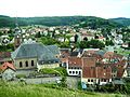
 Bitsch Center of the Citadel seen from |
||

Bitsch ( German and Lorraine ; French Bitche ) is a French city with 5098 inhabitants (as of January 1, 2017) in the Moselle department in the Grand Est region (until 2015 Lorraine ). It belongs to the Sarreguemines arrondissement , is the capital of the canton of Bitche and the seat of the Pays de Bitche municipal association .
The inhabitants call themselves Bitchois in French and Bitscher in German . Nickname: "Rampartritscher".
geography
Geographical location
The small town of Bitsch is not far from the border with Rhineland-Palatinate (20 kilometers south of Hornbach , 30 kilometers south of Zweibrücken and Pirmasens ) and the Saarland (30 kilometers southeast of Blieskastel and 50 kilometers from Saarbrücken ). The surrounding wooded region, the Bitscher Land , is named after her. The place is dominated by a sandstone plateau, on and in which the Citadel of Bitsch was built. The citadel was classified as a Monument historique in 1979 and is now an open-air museum . The city also has a share in the Northern Vosges Natural Park .
Neighboring communities of Bitsch are Hottviller and Schorbach in the north-west, Hanviller in the north, Haspelschiedt in the north-east, Stürzelbronn in the east, Éguelshardt in the south-east, Mouterhouse in the south and Lemberg and Reyersviller in the south-west.
Districts
Bitsch includes the residential areas Bitsch-Lager (French: Bitche-Camp ), Freundebergerhof, Ochsenmühle, Ramsteiner Mühle, Pfaffenberg, Stockbronn, Wolfsgarten and the old forester's house Biesenberg and the forester's house in Wolfsbronn. Former places to live are the cold kitchen, the Rochathof and the Ziegelscheuer.
history
The place arose from the Bithis Castle and the villages of Rohr and Kaltenhausen at its feet.
Other spellings were: Bitsch / Bitsche (1297), Bitchen (1321), Pitsch (1479), Bisch (1488), Bischt (1494), Bittsch (1592).
In the 12th and 13th centuries Bitsch belonged to the Duchy of Lorraine . In 1297, Lorraine exchanged rulership to the Counts of Zweibrücken-Bitsch , and Bitsch thus became the capital of an independent rulership until the line died out in 1570. Bitsch now fell by inheritance to the Lutheran county of Hanau-Lichtenberg . However, the Duke of Lorraine wanted to move in as feudal lord over Bitsch. From 1572 onwards there was a long-running dispute, which was only ended with a settlement in 1606. Bitsch fell back to Lorraine and was subsequently re-Catholicized. In the Thirty Years' War the town and the surrounding area were completely devastated. In 1680 France occupied the country. The subsequent conversion and redesign of the medieval castle into a modern fortress by Vauban and the constant presence of French troops had a lasting effect on the development of the place.
In the 17th and 18th centuries, Bitsch was repeatedly badly affected by wars and changed nationality between Lorraine and France several times until after the death of Stanislaus Leszczynski , the last Duke of Lorraine, Lorraine fell to France in 1766.
During the Franco-Prussian War of 1870/71, commander Louis-Casimir Teyssier defended the citadel , which had been besieged by Bavarian troops since August 8, 1870 . Teyssier only surrendered about a month after the preliminary peace of Versailles on March 25, 1871. The German army allowed the honorable withdrawal of the French soldiers under arms.
Bitsch now fell to the German Reich and, after the end of the First World War, returned to France in 1918. As a result, the citadel was integrated into the Maginot Line as a base . At the end of the Second World War , the citadel offered the inhabitants of Bitsch protection, especially from air raids.
In December 1944, American troops tried unsuccessfully to take Bitsch. They had to clear the southern surroundings of the city and the entire area east of it between Lauter and Moder during a tactical retreat in the course of the German New Year's offensives.
On March 15, 1945, the first day of Operation Undertone , US forces advanced into Bitsch and soon took the city. Their absolute air superiority helped them .

Bitsch around 1903
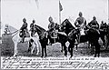
Bitsch - History: Imperial visit in 1903
Downtown


Population development
| year | 1962 | 1968 | 1975 | 1982 | 1990 | 1999 | 2007 | 2017 |
| Residents | 4277 | 5004 | 5055 | 5648 | 5517 | 5752 | 5555 | 5098 |
politics

Town twinning
Bitsch and the German city of Lebach in Saarland have been twinned since 1979 .
coat of arms
 |
Blazon : "In silver an openwork black diamond, from which a black snake winds up to the right and down to the left"
According to Lapaix, on an official picture at the Vienna World Exhibition, the snakes were red and crowned and the diamond blue. |
| Explanation of the coat of arms: In the Leipziger Illustrirten Zeitung it was assumed that the coat of arms was a talking one: the snake cold-blooded creatures, the rhombus floor plan of a house = Kaltenhausen. |
Culture and sights
.jpg)
Bitsch is located within the Northern Vosges Nature Park and has a well-known gastronomy. The main tourist attraction is the citadel, built by Vauban in 1680 on the site of a medieval castle.
The citadel can be visited. A video and audio guide (French, German or English) leads you through the corridors and rooms inside the building. The organizers of the exhibition succeeded in creating a neutral depiction of the Franco-German War, which particularly emphasizes the horrors of the war. The small church, as well as the other buildings on the citadel - which had survived the wars - have been restored.
Fort Simserhof , one of the five main works on the Maginot Line, is four kilometers west of the city . The underground fortress can be visited.
Bitsch participates in the international project Gardens without Borders with the Garden of Peace , which is designed as a connection between the city and the fortress. The visit to the garden is included in the entrance fee to the citadel. Since 2004 there has also been the Meteoric Garden , which was realized by the International Center for Glass Art in Meisenthal . In 2006 the Water Glass Garden was added, which aims to combine English gardening tradition with modern design. This garden was created by artists from Hadlow College in Greenwich .
At the foot of the citadel (south side) there is a small train station from the Wilhelmine era, which is well worth seeing, the structure of which is still in its original state.
traffic

Local rail transport
The station Bitsch is located at the disused section of Sarreguemines - Niederbronn the railway Haguenau Falck-Hargarten . Rail traffic on the route between Bitsch and Niederbronn has been completely idle since 1996. Therefore, trains from / to Saargemünd and Metz operated in Bitsch (terminus) from 1996 onwards . Because of insufficient profitability and damage to the superstructure , the Saargemünd – Bitsch section has also been closed since December 2011 and is served by buses in the replacement rail service.
Regular bus services From Bitsch there are regular bus services to Niederbronn, Hagenau and Saargemünd.
| Line course | Tact |
|---|---|
| Saargemünd - Wölflingen - Großrederchingen - Rohrbach Bf - Rohrbach Mitte - Kleinrederchingen - Enchenberg - Lemberg - Schwangerbach - Bitsch Stadtweiher - Bitsch Bf | 50 min. |
| Niederbronn Bf - Niederbronn Plant - Philippsburg - Lieschbach - Bannstein - Egelshardt - Bitsch Bf | 30 min. |
Road traffic The Départementstraße D 662 runs through the urban area. Coming from Saargemünd and the Neunkirchen district, it crosses Gros-Réderching , Rohrbach-lès-Bitche , Siersthal and Reyersviller , leads to Bitsch, crosses the Hornbach in the city and continues through Éguelshardt and Philippsbourg to Niederbronn and Haguenau .
Other important roads are:
- D 35: from the D 662 in the Frohmühle settlement above the Simserhof and the city center to Stürzelbronn and Wissembourg
- D 86: from the D 35 via Haspelschiedt , Waldhouse and Walschbronn to the German-French border at Kröppen to Pirmasens
- D 620: from the D 662 at the connection to the Hasselfurter Weiher to Saargemünd (with connection to the D 35A in the direction of Hornbach and Zweibrücken near Hottviller )
- D 962: from the D 35 north of the citadel via Breidenbach to the D 35A near Schweyen
Personalities
- Johann Reinhard I (1569–1625), regent of the County of Hanau-Lichtenberg from 1599 to 1625
- Franz von Pillement (1775–1836), Royal Bavarian Major General
- Auguste Daum (1853–1909), ceramicist and glass artist
- Hermann Florstedt (* 1895, † after 1945), SS-Standartenführer and concentration camp commander
- Pierre Gabriel (1933–2015), mathematician
Web links
- official page
- Bitsch Citadel on the Lviv Castle website
- Bitsch on the Bitscherland website (French)
Individual evidence
- ↑ Cercle "Die Furbacher", Histoire locale de Forbach , n ° 62, 2008.
- ↑ a b IGN map
- ^ Johann Siebmacher's large and general book of arms . Bauer and Raspe, Nuremberg 1885, p. 270 (378 pp., Uni-heidelberg.de ).
- ↑ Archive link ( Memento from 7 July 2009 in the Internet Archive )
- ↑ Timetable of the SNCF regional transport in Lorraine ( Memento of the original of April 30, 2011 in the Internet Archive ) Info: The archive link has been inserted automatically and has not yet been checked. Please check the original and archive link according to the instructions and then remove this notice.