Richeling
| Richeling | ||
|---|---|---|

|
|
|
| region | Grand Est | |
| Department | Moselle | |
| Arrondissement | Sarreguemines | |
| Community association | Sarreguemines Confluences | |
| Coordinates | 49 ° 2 ′ N , 6 ° 58 ′ E | |
| height | 217-264 m | |
| surface | 4.21 km 2 | |
| Residents | 337 (January 1, 2017) | |
| Population density | 80 inhabitants / km 2 | |
| Post Code | 57510 | |
| INSEE code | 57581 | |
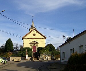
 Notre-Dame church |
||
Richeling (1801 still with the spelling Richling ; German Richelingen or Richlingen) is a French commune with 337 inhabitants (as of January 1, 2017) in the Moselle department in the Grand Est region (until 2015 Lorraine ). It belongs to the Sarreguemines arrondissement and the Sarreguemines Confluences municipality .
geography
The municipality of Richeling in northeast Lorraine is located in the area of the pond landscape that was created by the damming of the source rivers of the Moderbach ( Moderbach ), a tributary of the Albe . The reservoirs Étang de Welschhof, Étang des Marais and Étang de Hirbach are only two kilometers away from Richeling. They are developed for tourism and local recreation and are particularly popular with anglers and sailors. The municipal area of just 4.2 km² is drained by the Notterbach , which forms the north-western municipal boundary. Richeling has a small part of the Forêt de Sarralbe in the north-east , most of the gently hilly area consists of arable land and grassland.
Neighboring communities of Richeling are Grundviller in the north, Sarralbe and Holving in the southeast and Rémering-lès-Puttelange in the west.
Population development
| year | 1962 | 1968 | 1975 | 1982 | 1990 | 1999 | 2007 | 2017 | |
| Residents | 192 | 193 | 210 | 262 | 317 | 313 | 356 | 337 | |
| Sources: Cassini and INSEE | |||||||||
Attractions
- Notre-Dame church from 1843
Economy and Infrastructure
Richeling is a small community and has long been shaped by agriculture. Many houses are more recent and an expression of the sustained population growth in recent years, which is due to the proximity to the lakes in the area on the one hand, and the large companies such as Smartville or Ineos (petrochemicals) on the other, and which encouraged the influx of many employees there. There are four farms in the municipality (breeding cattle, sheep and goats).
National road 56 from ( Saint-Avold to Sarralbe ) runs through Richeling . The connection Puttelange-aux-Lacs on the Paris-Strasbourg motorway is only four kilometers away from Richeling. The nearest train stations are in Sarralbe and Loupershouse .
supporting documents
- ↑ toponym on cassini.ehess.fr
- ↑ Repertoire alphabétique des communes et annexes de l'arrondissement (French)
- ↑ Ewald Crusius: The changes in the population density in the Lorraine districts Forbach and Saargemünd 1801-1910 limited preview in the Google book search
- ↑ Richeling on cassini.ehess.fr
- ↑ Richeling on insee.fr
- ↑ Farms on annuaire-mairie.fr (French)
