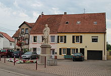
Blies-Guersviller
| Blies-Guersviller | ||
|---|---|---|

|
|
|
| region | Grand Est | |
| Department | Moselle | |
| Arrondissement | Sarreguemines | |
| Canton | Sarreguemines | |
| Community association | Sarreguemines Confluences | |
| Coordinates | 49 ° 9 ' N , 7 ° 5' E | |
| height | 197-287 m | |
| surface | 3.60 km 2 | |
| Residents | 644 (January 1, 2017) | |
| Population density | 179 inhabitants / km 2 | |
| Post Code | 57200 | |
| INSEE code | 57093 | |
 Saint-Quirin church in the Blies-Schweyen district |
||
Blies-Guersviller (German Bliesgersweiler ) is a French commune with 644 inhabitants (as of January 1, 2017) in the Moselle department in the Grand Est region (until 2015 Lorraine ).
geography
The municipality of Blies-Guersviller is located on the Blies , which frames the municipality in a horseshoe shape and forms the border with Germany . Blies-Schweyen is the largest part of the municipality, it is located in the northeast opposite the Saarland village of Blieshaben-Bolchen .
Neighboring communities of Blies-Guersviller are Kleinblittersdorf in the west and north, Mandelbachtal in the east (both communities in Saarland ), Frauenberg in the southeast and Saargemünd in the south.
history
The place was first mentioned in a document in 777 as Villare , then in 1261 as Gereswilre and in 1751 as Guércheviller . In 1811, Blies-Schweyen was merged with Blies-Guerschwiller .
The Bliesgersweiler mill came to Prussia in 1829 through the border convention between Prussia and France .
Population development
| year | 1962 | 1968 | 1975 | 1982 | 1990 | 1999 | 2007 | 2014 |
|---|---|---|---|---|---|---|---|---|
| Residents | 362 | 373 | 313 | 542 | 628 | 661 | 609 | 603 |

