Kirviller
| Kirviller | ||
|---|---|---|

|
|
|
| region | Grand Est | |
| Department | Moselle | |
| Arrondissement | Sarreguemines | |
| Canton | Sarralbe | |
| Community association | Sarreguemines Confluences | |
| Coordinates | 48 ° 57 ' N , 6 ° 59' E | |
| height | 213-246 m | |
| surface | 2.54 km 2 | |
| Residents | 141 (January 1, 2017) | |
| Population density | 56 inhabitants / km 2 | |
| Post Code | 57430 | |
| INSEE code | 57366 | |
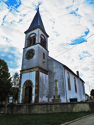
 Saint-Michel church |
||
Kirviller (German Kirweiler ) is a French commune with 141 inhabitants (as of January 1, 2017) in the Moselle department in the Grand Est region (until 2015 Lorraine ). It is part of the Sarreguemines arrondissement and the Sarralbe canton .
geography
The municipality of Kirviller is located five kilometers southwest of Sarralbe in northeast Lorraine.
history
The community was first mentioned in 1179 as Kirwilra .
Population development
| year | 1962 | 1968 | 1975 | 1982 | 1990 | 1999 | 2009 | 2015 |
| Residents | 156 | 157 | 133 | 114 | 107 | 103 | 147 | 146 |
Attractions
- Saint-Michel church from 1858
Web links
Commons : Kirviller - collection of images, videos and audio files
