Bliesbruck
| Bliesbruck | ||
|---|---|---|

|
|
|
| region | Grand Est | |
| Department | Moselle | |
| Arrondissement | Sarreguemines | |
| Canton | Sarreguemines | |
| Community association | Sarreguemines Confluences | |
| Coordinates | 49 ° 7 ' N , 7 ° 11' E | |
| height | 202-362 m | |
| surface | 10.88 km 2 | |
| Residents | 1,017 (January 1, 2017) | |
| Population density | 93 inhabitants / km 2 | |
| Post Code | 57200 | |
| INSEE code | 57091 | |
| Website | http://www.bliesbruck.com/ | |
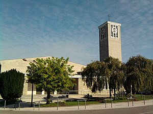
 Sainte-Catherine church |
||
Bliesbruck (German Bliesbrücken ) is a French commune with 1017 inhabitants (as of January 1, 2017) in the Moselle department in the Grand Est region (until 2015 Lorraine ).
geography
The municipality of Bliesbruck lies on both sides of the Blies on the border with Saarland , about ten kilometers east of Saargemünd . The district Hermeskappel belongs to the municipality .
Neighboring communities of Bliesbruck are Gersheim (Saarland) in the north, Obergailbach in the east, Gros-Réderching in the south-east, Wœlfling-lès-Sarreguemines in the south, Wiesviller in the south-west, Blies-Ébersing in the west and Mandelbachtal (Saarland) in the north-west.
history
Before the village was founded, there was a small Roman town ( vicus ) north of the later village from 40/50 - 450 AD , the remains of which have been excavated since 1971. The ancient name of the settlement is still unknown. The ruins are now part of the Parc Archéologique Européen / European Culture Park Bliesbruck-Reinheim .
Evidence of the foundation of Bliesbruck in the early Middle Ages (6th / 7th centuries) is provided by Merovingian graves. In the Middle Ages, Bliesbruck belonged to the Counts of Blieskastel . In 1781 Count Philipp Franz von der Leyen handed the place over to France.
After the Franco-Prussian War in 1871, Alsace-Lorraine and thus also Bliesbruck were incorporated into the German Empire before the areas were re-annexed to France after the First World War .
The border town was badly damaged in the Second World War . Then the center of the village shifted to the left side of the Bliess. The destroyed old church was torn down and replaced by a new building on the opposite bank.
Population development
| year | 1962 | 1968 | 1975 | 1982 | 1990 | 1999 | 2007 | 2014 |
| Residents | 903 | 918 | 867 | 965 | 915 | 984 | 1017 | 997 |
Attractions
- Parc Archéologique Européen / European Cultural Park Bliesbruck-Reinheim . The cross-border archaeological park extends over around 70 hectares between the places Bliesbruck (F) and Reinheim (D) and shows the preserved wall remains of a small town and manorial villa from Roman times as well as a reconstructed princess grave from Celtic times. The park also houses various exhibition buildings.
Web links
- Community presentation (French)
- European culture park Bliesbruck- Reinheim
