
Albe (river)
| Alb | ||
.png) Course of the alb |
||
| Data | ||
| Water code | FR : A91-0200 | |
| location |
France
|
|
| River system | Rhine | |
| Drain over | Saar → Moselle → Rhine → North Sea | |
| source | in the municipality of Rodalbe 48 ° 54 ′ 42 ″ N , 6 ° 41 ′ 33 ″ E |
|
| Source height | approx. 251 m | |
| muzzle | in the municipality of Sarralbe in the Saar Coordinates: 49 ° 0 '14 " N , 7 ° 1' 58" E 49 ° 0 '14 " N , 7 ° 1' 58" E |
|
| Mouth height | approx. 210 m | |
| Height difference | approx. 41 m | |
| Bottom slope | approx. 1.2 ‰ | |
| length | 33.3 km | |
| Catchment area | 409.8 km² | |
| Drain at the mouth |
MQ |
3.7 m³ / s |
| Left tributaries | Buschbach | |
| Right tributaries | Mutterbach , Rode | |
| Reservoirs flowed through | Etang de Rodalbe, Etang de Besville | |
 The river at Insming |
||
 The Albe near Léning in Lorraine |
||
The Albe is a river in France that runs in the Moselle department in the Grand Est region . It rises in the municipality of Rodalbe , generally drains in a north-easterly direction and flows just over 33 kilometers north of Sarralbe , as a left tributary into the Saar .
geography
course
The Albe follows several municipal boundaries in its course: Bermering and Virming are on the left, Bénestroff and Neufvillage on the right. After crossing the municipal area of Francaltroff , the disused railway line Bénestroff - Sarralbe follows its valley from Léning . This is followed by Nelling on the left and Insming on the right. Here it also briefly forms the northern border of the Lorraine Regional Nature Park . It takes the Buschbach on the left and passes the villages of Kappelkinger and Le Val-de-Guéblange . Between Le Val-de-Guéblange and Sarralbe, it takes the Mutterbach on the left and the Rode on the right. In Sarralbe it is from the Saar channel crosses and opens against the district Salzbronn to 210 meters above sea level, in the Saar .
Catchment area
The catchment area of the Zorns is 409.8 km² and consists of 73.26% of agricultural area, 19.48% of forest areas, 1.76% of water surfaces and 5.51% of built-up areas.

Tributaries
Order in flow direction:
- Ruisseau Harcheidraben ( left ), 3.1 km
- Ruisseau des Etangs Benestroff ( right ), 6.2 km
- Ruisseau le Lenzbronn ( Lenzbronnerbach ) ( left ), 9.0 km
- Ruisseau le Brouch ( Ruisseau le Brouque ) ( right ), 5.4
- Ruisseau le Petit Brouch ( right ), 2.0 km
- Ruisseau du Dahl ( right ), 3.2 km
- Le Britgraben ( left )
- Suessmattegraben ( left )
- Ruisseau le Matzengraben ( left ), 4.9 km
- Lazelle ( Buschbach ) ( left ) 15.3 km, 48.1 km², 0.395 m³ / s
- Lempichgraben ( left )
- Pipe trench ( right )
- Mutterbach ( Ruisseau de Moderbach ) ( left ), 21.8 km, 89.5 km², 0.79 m³ / s
- La Rose ( Ruisseau la Rode ) ( right ), 24.8 km, 127.1 km², 1.24 m³ / s
Places on the river
Order in flow direction:
Hydrology
At the confluence with the Saar, the mean flow rate (MQ) is 3.7 m³ / s; the catchment area here covers 409.8 km².
In Sarralbe , the average annual runoff of the Albe was calculated over a period of 52 years (1967–2018) . The catchment area at this point corresponds to about 409 km², almost 100% of the entire catchment area of the river.
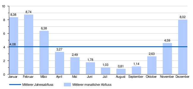
The flow rate of the Albe, with the annual average of 4.08 m³ / s, fluctuates quite strongly in the course of the year. The highest water levels are measured in the winter months from December to February. The flow rate reached its peak in February at 8.7 m³ / s. From March onwards the discharge drops sharply month after month and reaches its lowest level in August with 0.8 m³ / s, after which it increases again from month to month.
The monthly mean discharge (MQ) of the Albe in m³ / s, measured at the hydrological station L'Albe à Sarralbe [Eich].
Data calculated from the values from 1967 - 2018
Individual evidence
- ↑ Source geoportail.gouv.fr
- ↑ estuary geoportail.gouv.fr
- ↑ a b c Albe at SANDRE (French)
- ↑ a b c Débits caractéristiques de l'Albe (French; PDF file; 14 kB)
- ↑ Length information according to SANDRE
- ↑ a b Self-measurement on Géoportail
- ↑ Banque Hydro - Station A9192060 - L'Albe à Sarralbe [Eich], (menu item: Synthèse)
Web links
- Alb at SANDRE (French)
- Débits caractéristiques de l'Albe (French; PDF file; 14 kB)
- Course of the alb on Géoportail
- Course of the alb on SANDRE