Heckendalheim
|
Heckendalheim
community Mandelbachtal
|
||
|---|---|---|
| Coordinates: 49 ° 13 ′ 44 ″ N , 7 ° 8 ′ 15 ″ E | ||
| Height : | 323 (280-380) m | |
| Area : | 3.9 km² | |
| Residents : | 1134 (Feb. 2016) | |
| Population density : | 291 inhabitants / km² | |
| Incorporation : | 1st January 1974 | |
| Postal code : | 66399 | |
| Area code : | 06803 | |
|
Location of Heckendalheim in Saarland |
||
|
View from the southeast from Mühlenberg near Ormesheim to Heckendalheim
|
||
Heckendalheim is a part of the municipality of Mandelbachtal in Saarland .
location
Heckendalheim is located in the UNESCO - Biosphere Reserve Bliesgau of the southeastern part of Saarland . The older part of the village stretches like a street village from north-west to south-east with a height difference of approx. 80 m. The new part of the settlement (from around 1965) is located on the northern hill of the village.
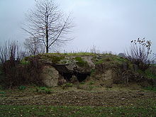
The place is framed by fields and orchards . Thanks to the land consolidation that was not carried out , the original landscape structure was retained. Together with the bushes on the ruins of the former hump line , the blown up Westwall bunkers also shape the landscape around Heckendalheim.
The Way of St. James from Speyer to Metz leads through Heckendalheim.
history
Place name
The village was called "Dalheim" until the 17th century.
"Dal" comes from the Old High German word dala , dal , tal = the valley. The component "heim", old high German home , means house, place of residence or home. Dalheim can therefore be explained as a home (village) in the valley.
The addition "hedges" only appeared in the 17th century in order to better distinguish the place from the "Dalheim" of the same name in the valley of the Blies . The former was called Bliesdalheim to distinguish it , this one at the transition from the St. Ingberter Wald to the Gau , to distinguish Heckendalheim. Comparable developments in place names can be found in the vicinity, for example at Bliesransbach and Heckenransbach (both originally "Ransbach") or the Bickenaschbacher and Heckenaschbacher Hof near Zweibrücken (both originally "Aschbach").
According to the prevailing opinion, "hedges" mean the dense vegetation of hedges within the boundary of the village. There is no connection with the place “St. Hequinet “( Sengscheid ).
The extended place name can be found for the first time in a document from 1655 in which Wolf Henrich v. Steinkallenfels "Heckendalheim", "Onnerßheim" ( Ommersheim ) and other villages sold to the Elector and Archbishop of Trier Karl Kaspar von der Leyen .
The locals do not usually use the suffix "hedges", they simply call the village "Dalem".
Antiquity
An early settlement by the Celtic tribe of the Mediomatriker , who inhabited the region during the La Tène period , is possible, if not proven. The favorable location of the village with the three water-rich valleys, which are protected to the north and east and open to the south, as well as the fertile ridges in between, are in any case an ideal prerequisite for a rural settlement.
Extensive finds of coins and terra sigillata fragments as well as settlement remains attest to the existence of Roman farmsteads throughout the area around Heckendalheim.
middle Ages
In the early Middle Ages, free Franconian farmers settled in the area .
The part of the name “ -heim ” is typical for villages that were settled during the Frankish conquest in the 6th - 7th centuries. Grave finds from the 7th century ( Ponsheimer Hof ) also prove the settlement of the surrounding area by the Franks . Heckendalheim as a village could therefore have originated around the year 600 at the time of the Merovingians . Corresponding archaeological finds in the village itself are not available, but after 780 there is generally no evidence of a new establishment with the ending "heim".
Noble landlords appear for the first time in the 9th century . From the 12th century onwards, as in the rest of Germany, feudal law was decisive for the social order.
Heckendalheim was first mentioned in a document in 1342.
In this document, the nobleman Johann von Bübingen declares that he has done the Wadgassen monastery an injustice with his claims against the people of Wirzebach ( Oberwürzbach ) and Dalen . The people mentioned belong to the monastery because his father Hugelo von Ensheim sold them to the Wadgassen monastery in 1304. Johann promises to make no more demands or claims (his son Hugelo was to break this promise a little later).
The certificate bears the date "Friday before half-fast 1341". Due to the shift in the year due to the annunciation style used in the document , according to which the year begins on March 25th ( Annunciation ), according to today's count, the first documentary mention of Heckendalheim is March 8, 1342.
The Bliesgau , to which Heckendalheim belongs, is under the rule of a large number of clerical and noble landlords and court lords until the area finally becomes part of Kurtrier in 1444 .
The Archbishop of Trier appoints a bailiff in Blieskastel for administration. He is responsible for collecting taxes, and on behalf of the Elector he is also the court lord.
Early modern age
In the period from 1534 to 1814, Heckendalheim changed hands several times.
The Lords of Steinkallenfels , the Counts of Nassau-Saarbrücken and the Lords of Eltz have been fighting over years of court proceedings and small-scale wars over the rights of rule . On April 26, 1655, Wolf Henrich von Steinkallenfels finally sold the rights and property of the villages of Heckendalheim and Ommersheim to Elector Karl Kaspar von der Leyen due to lack of money . The purchase price is 2100 Reichstalers and a load of Moselle wine, which corresponds to around 1000 liters in this area at that time. In the corresponding documents, the extension of the place name to "Hecken" -Dalheim appears for the first time.
The new masters find a village devastated by the Thirty Years' War and deserted. But resettlement began as early as 1661, and in 1690 seven families were again living in Heckendalheim. Economic and social development begins, and at the end of the 18th century 143 people are living in the village again.
In 1786 serfdom was lifted by Countess Marianne von der Leyen , who lived in Blieskastel . In 1793 the countess had to flee from the French revolutionary armies .
A consequence of the beginning of French rule, which is still clearly visible today, are the ban boundary stones , the location of which goes back to a large extent to the first recorded survey from 1802–1805. During this time, a complete “ring” of 55 boundary stones was established around the Heckendalheim community ban, which is still the community boundary today . The corresponding plan bears the date "26 Germinal to 13" of the French revolutionary calendar , that is April 16, 1805.
The Bavarian time
As a result of the Congress of Vienna , Heckendalheim was assigned to the Kingdom of Bavaria from 1816 . The municipality colors white and blue come from this time.
After the First World War
For Heckendalheim, too, the special history of the Saarland is decisive for the period after the First World War .
The installation of the local network for light and electricity takes place in 1921/1922.
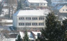
The new school building was inaugurated on July 11, 1932. The old school house from 1840 had become too small for the growing village community.
The second World War
The Siegfried Line
Particularly noteworthy is the Siegfried Line , which was built between September 1938 and August 1939 and runs right through the village. With a population of around 700 at that time, Heckendalheim took in around 500 Westwall workers. The construction of the west wall brings the village temporarily an economic upswing, e.g. for the catering trade, the hauliers and the renters of sleeping places.
The now overgrown hump line and the blown bunkers are still clearly visible in many places in the village. On March 15, 1945, one of the most violent artillery battles of the Second World War took place on this section of the Western Wall. Heckendalheim is not the direct target of these attacks. Nevertheless, the village is badly affected by the war due to its location on the Siegfried Line.
The evacuations
Like other places in the border area, Heckendalheim is also in the so-called Red Zone , which must be evacuated by the civilian population at the beginning of the war.
This first evacuation began on August 29, 1939, three days before the war actually started. Except for the fire brigade and an emergency service, all the residents of the village are transported to Eulenbis near Kaiserslautern. After three days in the completely overcrowded place, the journey continues by train to Franconia , Kurhessen, Thuringia and Upper Franconia (e.g. Ludwigschorgast and Weidenberg ). The cattle that have been left behind are also transported away, some inland and some are also sent to the slaughterhouses. The Heckendalheim farmers never see their cattle again.
From August 1940 the evacuees were given permission to return.
As the front approached in autumn 1944, the population was evacuated a second time.
Redesign of the town center
At the time when the population returned from the first evacuation in August and September 1940, the Todt organization "beautified" the place . The OT has the task of creating a large square in the middle of Heckendalheim. Because houses are in the way of the plan, a number of inhabited buildings, including the old schoolhouse from 1840 (in the picture below), have to be demolished. This happens under sometimes dramatic circumstances without regard to the population and leads to the irretrievable disappearance of a lovable part of the old village.
In the 1960s, more houses were demolished as part of the renovation of the village square.
The end of the war
Between Christmas and New Year 1944, the men from the evacuation to the Volkssturm were ordered back to Heckendalheim. Most of the Volkssturm men are miners and have no military training. Accordingly, they are mainly used for jumps, to secure property, in the repair area and as a guard at the anti-tank barrier in Unterdorf and the road barrier in Oberdorf in what was then Adolf-Hitler-Strasse (today St. Ingberter Strasse).
Heckendalheim is particularly at risk due to its exposed location on the Siegfried Line. On the night of March 14th to 15th, 1945, heavy artillery fire began by the Americans, not only aimed at the Siegfried Line. Many houses in the village are badly damaged in some cases.
Between March 16 and 19, 1945, Heckendalheim was in American hands several times, but massive German resistance prevented the Americans from occupying the village. It was not until March 19 that the resistance was broken and the Americans went from house to house to get the frightened population out of the basements.
On March 20, 1945, in the course of this attack, the breakthrough through the Siegfried Line in the Ensheimer Tal succeeded. The war is over in Heckendalheim. However, it took until December 1949 for the last prisoner of war to see home again, and 53 fallen or missing persons were never to return to Heckendalheim.
the post war period
In 1952 and 1953 the new church was built with the participation of the population. The sandstones used for the construction come from quarries in Heckendalheim, the stones are transported by local farmers and hauliers. The remains of the hump line find a new use as the foundation of the church. The consecration of the church can take place on August 30, 1953 (exactly one year after the laying of the foundation stone).
In 1957, the Saarland is incorporated into the Federal Republic of Germany as the eleventh federal state.
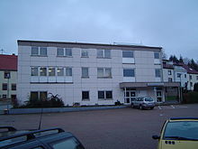
The newly built village community center, which clearly shows the predominant functional architectural style of the time, was inaugurated in 1968.
Municipal boundaries and administrative allocation
The administrative allocation of Heckendalheim has changed again and again over the centuries. It is noteworthy that the administrative organizations in which Heckendalheim was involved over the past 200 years have remained largely unaffected by the great upheavals in world history.
After Heckendalheim was the property of various rival lords in the Middle Ages, the village belonged to von der Leyen from 1655 to 1793 . Then French troops occupy the area and the village comes under French administration, the official language is French.
After being assigned to the Kingdom of Bavaria, the village belonged to the Ensheim mayor from 1817 . From 1852 Heckendalheim, together with the neighboring villages of Oberwürzbach and Ommersheim, forms the mayor's office in Ommersheim. The administrative seat of this mayor's office is for a short time (1890–1899) Heckendalheim.
In 1925 a separate mayor's district was founded for Oberwürzbach. Heckendalheim and Ommersheim remain linked together in the mayor's office Ommersheim, which is converted into the Ommersheim office in 1951 .
In 1969 the Heckendalheim community received its own coat of arms.
On January 1, 1974, Heckendalheim was incorporated into the new municipality of Mandelbachtal. This ends the long-standing administrative connection with Ommersheim.
politics
Local council
Distribution of seats in the local council :
(As of May 2014)
Mayor
Mayor is Andreas Greß ( SPD ).
coat of arms
Since 1969 Heckendalheim has had its own coat of arms with the following description :
“Divided above in silver, a blue pole topped with a growing silver abbot's staff and accompanied on the right by a silver-tongued blue leopard growing out of the split and on the left by a crowned blue lion; a silver pole below in blue. "
Parish partnership
Saône (France, Doubs department )
This partnership between Heckendalheim and Saône begins on November 21, 1970. It is one of the first of its kind and is still maintained today.
dialect
The dialect spoken in Heckendalheim belongs to the Rhine Franconian , more precisely to the Palatinate in the subspecies of the Southwest Palatinate. Heckendalheim is surrounded by a number of linguistic lines that illustrate the large number and variety of dialects in Saarland .
Like every village in the area, Heckendalheim also has its own unmistakable dialect, which the younger generation also uses as a matter of course. However, agricultural dialect terms in particular are increasingly being lost because they no longer have any meaning in everyday language use.
Economy and Infrastructure
traffic
Despite its rural location, Heckendalheim has extensive transport links. The state capital Saarbrücken is 16 km away. St. Ingbert as a shopping center is 8 km away and the district town of Homburg is 23 km away. The A 6 motorway is 5 km away, and Saarbrücken Airport is 3 km from Heckendalheim. The French border is 14 km away.
literature
- 650 Years of Heckendalheim , Volumes 1 and 2, edited by the “Heckendalheimer Dorfbuch” working group, 1992.
- A house full of glory looks , Festschrift on the occasion of the consecration of St. Joseph's Church, August 30, 1953.
- Triumph of Faith - The Catholic Parish Church of St. Josef , published by the Mandelbachtal Tourist Association, 2012
- The Way of St. James - rediscover historical pilgrimage routes through the municipality of Mandelbachtal , published by the Mandelbachtal Tourist Office, 2009
- The coat of arms of the Mandelbachtal community and its eight districts , published by the Mandelbachtal Tourist Office, 2009
Web links
- Website of the municipality of Mandelbachtal
- Literature on Heckendalheim in the Saarland Bibliography
Individual evidence
- ^ Federal Statistical Office (ed.): Historical municipality directory for the Federal Republic of Germany. Name, border and key number changes in municipalities, counties and administrative districts from May 27, 1970 to December 31, 1982 . W. Kohlhammer, Stuttgart / Mainz 1983, ISBN 3-17-003263-1 , p. 809 .
- ↑ Local councils Mandelbachtal ( Memento of the original from December 18, 2011 in the Internet Archive ) Info: The archive link was inserted automatically and has not yet been checked. Please check the original and archive link according to the instructions and then remove this notice. (PDF; 263 kB), on: www.mandelbachtal.de, accessed on June 26, 2012
- ↑ Mayor of the Mandelbachtal community ( Memento of the original from December 18, 2011 in the Internet Archive ) Info: The archive link has been inserted automatically and has not yet been checked. Please check the original and archive link according to the instructions and then remove this notice. (PDF; 176 kB), on: www.mandelbachtal.de, accessed on November 1, 2014


