Bliesdalheim
|
Bliesdalheim
community Gersheim
|
||
|---|---|---|
| Coordinates: 49 ° 10 ′ 27 ″ N , 7 ° 14 ′ 16 ″ E | ||
| Height : | 224 (212-390) m above sea level NHN | |
| Area : | 3.71 km² | |
| Residents : | 590 (2019) | |
| Population density : | 159 inhabitants / km² | |
| Incorporation : | 1st January 1974 | |
| Postal code : | 66453 | |
| Area code : | 06843 | |
|
Location of Bliesdalheim in Saarland |
||
|
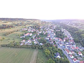
View of Bliesdalheim
|
||

Bliesdalheim (in the local dialect Dalem ) is a village in the municipality of Gersheim in the Saarpfalz district ( Saarland ) with 580 inhabitants. Until the end of 1973, Bliesdalheim was an independent municipality in the Homburg district .
geography
Bliesdalheim is located in the southeast of Saarland and in the middle of the Bliesgau biosphere reserve , only a few kilometers from the German-French border. The Blies flows past the place . The district takes up an area of 371 ha. Of this, around 68 ha are used for agriculture, around 60 ha are overgrown with forest. The district of the village borders the districts of Blieskasteler districts Böckweiler , Breitfurt and Wolfersheim and to which the Gersheimer districts Herbitzheim and Walsheim . To the northeast of Bliesdalheim rises the Kahlenberg (401 m above sea level), the highest point in the Bliesgau.
history
prehistory
Paleolithic stone tools (800,000-200,000 before today), Neolithic stone axes (4th millennium BC), Hallstatt burial mounds in the "Great Forest" (8th / 7th centuries BC ) date from the time before the village was founded .) as well as three Roman settlements ( villae rusticae ) (1st – 4th centuries AD).
Local history
A Merovingian grave and the ending - heim speak for a foundation in the early Middle Ages (6th / 7th centuries). The village first appeared in documents in the 13th century. In the regests of the Wörschweiler monastery in 1218 it is mentioned that Godefried Graf von Sponheim bequeathed the income from his court in Daleheim to the monastery . The regests of the Wörschweiler monastery mention "Daleheim or Dalheim" in several places. A Bliesmühle is documented for the first time in the 14th century.
In the High Middle Ages , Wörschweiler Monastery had extensive ownership rights to the village. In the north-east of today's village there was once a neighboring town called Ster (n) weiler , which fell into desolation by the 16th century at the latest. Until the French Revolution , Bliesdalheim was largely owned by the Dukes of Pfalz-Zweibrücken and served as the court for the Palatinate-Zweibrücken Bliesdörfer. In the Thirty Years War the place was badly affected. While 86 inhabitants have survived in 1624, three families still lived in the village after the end of the war. Around 1670 further destruction followed in the course of the Reunion Wars .
As of 1798, like all areas on the left bank of the Rhine , it belonged to France . Due to the resolutions at the Congress of Vienna (1815), the village was a Bavarian municipality from 1816 . To distinguish it from Heckendalheim , the place has since had the name of the river flowing past (Blies-) as a prefix. From 1879 the place was connected to the railway network of the Bliestalbahn .
According to the Versailles Treaty , the Saar area was under French administration from 1920 to 1935, following a mandate from the League of Nations . From 1922 there was electric light in the village, from 1927/28 running water.
After the Saar referendum, the Saar area was annexed to the National Socialist German Reich in 1935 . On September 1, 1939, at the beginning of the Second World War , the village was evacuated. The residents were taken to Thuringia , Upper Franconia and the Odenwald in special trains . The village was only allowed to be inhabited again in May 1941. In 1939, German soldiers blew up the old stone arch bridge over the Blies, which dates back to 1769. A second evacuation followed in December 1944. In 1939 and 1945 the place suffered severe destruction. 75 of 115 properties were demolished. As a result, the place largely lost its original character as a farming village.
From 1946 to 1957, Saarland was an autonomous state under French protectorate. After the referendum of 1955, it joined the Federal Republic of Germany . In 1956 the turbine house of the Bliesmühle was shut down after the other mill buildings had been completely destroyed in 1939/45. After several temporary bridges, today's reinforced concrete bridge was built over the Blies in 1960.
Since the regional and administrative reorganization , which came into effect on January 1, 1974, the formerly independent municipality of Bliesdalheim has belonged to the municipality of Gersheim. Today most of the residents are commuters to the surrounding cities. On June 1-3, 2018, Bliesdalheim celebrated its 800th birthday, as the place name was first mentioned in a document 800 years ago.
Population development
| year | 1547 | 1609 | 1624 | 1675 | 1802 | 1837 | 1852 | 1895 | 1905 | 1910 | 1932 | 1952 | 1961 | 1970 | 1974 | 1982 | 2002 | 2005 | 2010 | 2019 |
| Residents | 13 Fam. |
75 | 86 | 3 family |
276 | 336 | 358 | 401 | 459 | 492 | 528 | 509 | 646 | 648 | 659 | 602 | 620 | 680 | 705 | 590 |
politics
Local council
Distribution of seats in the local council
Mayor and Mayor
- mayor
- 1963–1974: Alfons Kohl (CDU)
- Mayor
- 1974–1984, 1989–1994: Alfons Kohl (CDU)
- 1994–2015: Klaus Fischer (CDU)
- since 2015: Bernhard Welsch (CDU)
nature and landscape
Most of the area is covered with shell limestone ; The Upper Buntsandstein can only be found on the northern boundary of the district . Due to the high groundwater level and regular flooding, the Bliesaue is an important habitat for many animal and plant species. The banks of the Blies are bordered by black poplars , willows and sometimes black alder forests . After being released into the wild, the beaver has been at home again for several years .
Probably nothing is more characteristic of the Bliesgau than its orchard meadows that characterize the valley slopes next to isolated arable land. The field name "Rebenberg" is a testimony to earlier viticulture that was practiced on a small scale in the region.
In the deciduous forest on the ridge east of the village, beeches and common oaks dominate .
Attractions
- To the northeast of the village is an ice cellar carved out of the red sandstone with a length of 26 m, a width of 4.80 m and a height of about 5 m. The traces of processing indicate a time of origin in the 18th century. The name comes from the use of the cave in the 19th century as an ice cellar, in which broken ice was stored on the Blies in winter. The ice cellar is a winter quarters for bats. Guided tours are offered in the summer months.
- Catholic parish church of St. Wendelinus (1801, expanded 1919–1923). The cath. The parish was founded in 1893 by a large, testamentary gift of fortune from the Franco-German Baron Alexandre Louis Guillaume Jacomin de Malespine (1821-1893), lord of the Kirchheimer Hof, from which the money for the church was later used. There is an inscription of thanks for the nobles in the church.
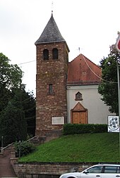
- Evangelical Church (tower 1907, nave 1926/27)
- Cholerakreuz, a wayside cross from 1854 on the corner of Bliestalstrasse and Wendelinusstrasse.
The ice cellar, the Catholic church and the cholera cross are listed as individual monuments in the Saarland's list of monuments . The list also includes a farmhouse built around 1800 on Bliestalstrasse.
societies
- Gymnastics: TV 1898 Bliesdalheim
- Soccer: SG Hertbitzheim-Bliesdalheim (created in 1972 from the merger of SSG Bliesdalheim and SV Herbitzheim). The club plays in the district league A - Bliestal
- DRK local association Bliesdalheim
- Volunteer firefighter
- Village friends Bliesdalheim
- Fruit and horticultural association Bliesdalheim
- Fishing club Bliesdalheim
Personalities
- Andreas Grieser (1868–1955), district judge and public prosecutor in the Bavarian State Ministry of Justice, Mayor of Würzburg , District Administrator of the St. Ingbert District, State Secretary in the Bavarian State Ministry of Labor
- Ludwig Maria Hugo (1871–1935), Bishop of Mainz (1921–1935), fighter against National Socialism, pastor of Bliesdalheim 1911–1915.
- Sammy Vomáčka (* 1946 in Brandys nad Labem , real name Jiří Vomáčka ), from the Czech Republic originating guitarist , lives in Bliesdalheim since of 2003.
Web links
Individual evidence
- ↑ red./ott: history - Bliesdalheim. April 21, 2018. Retrieved June 17, 2018 .
- ^ Federal Statistical Office (ed.): Historical municipality directory for the Federal Republic of Germany. Name, border and key number changes in municipalities, counties and administrative districts from May 27, 1970 to December 31, 1982 . W. Kohlhammer, Stuttgart / Mainz 1983, ISBN 3-17-003263-1 , p. 809 .
- ↑ red./ott: history - Bliesdalheim. April 21, 2018. Retrieved June 17, 2018 .
- ^ Community of Gersheim - Sights at: www.gersheim.de, accessed on June 29, 2012
- ↑ List of monuments of the Saarland, sub-monuments list Saarpfalz-Kreis (PDF; 1.2 MB), accessed on June 29, 2012


