
Wolfersheim
| coat of arms | Germany map | |
|---|---|---|

|
Coordinates: 50 ° 24 ' N , 8 ° 49' E |
|
| Basic data | ||
| State : | Hesse | |
| Administrative region : | Darmstadt | |
| County : | Wetteraukreis | |
| Height : | 160 m above sea level NHN | |
| Area : | 43.11 km 2 | |
| Residents: | 9784 (Dec. 31, 2019) | |
| Population density : | 227 inhabitants per km 2 | |
| Postcodes : | 61200, 61209 (cross source) |
|
| Area code : | 06036 | |
| License plate : | FB, BÜD | |
| Community key : | 06 4 40 024 | |
| LOCODE : | DE WFM | |
| Community structure: | 5 districts | |
| Address of the municipal administration: |
Hauptstrasse 60 61200 Wölfersheim |
|
| Website : | ||
| Mayor : | Eike See ( SPD ) | |
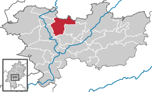
| Location of the community of Wölfersheim in the Wetterau district | ||
  |
||

Wölfersheim is a municipality in the Wetterau district in Hesse .
geography
Geographical location
Wölfersheim is 40 km north of Frankfurt am Main in the Wetterau, not far from the cities of Bad Nauheim and Friedberg (Hesse) . The community is conveniently located on the A 45 with its own exit Wölfersheim . The local recreation areas Wetterauer Seenplatte , Niddastausee and Vogelsberg are right on the doorstep.
Neighboring communities
Wölfersheim borders in the north on the cities of Munzenberg and Hungen ( district of Gießen ), in the east on the communities Nidda and Echzell , in the south on the cities of Reichelsheim and Friedberg (Hesse) , and in the west on the city of Bad Nauheim and the community Rockenberg (all in the Wetterau district).
Community structure
Wölfersheim merged in the course of the regional reform in Hesse on December 31, 1970 with the places Melbach , Södel and Wohnbach to form the large community of Wölfersheim. On December 31, 1971, Berstadt also joined the community.
Almost 10,000 people currently live in the large community.
history

Due to its location in the fertile Wetterau, numerous cultures have visited the area. Grave finds from the Bronze Age were name-giving for the stage Wölfersheim . The finds are exhibited today in the Wetterau Museum in Friedberg.
Remains from Roman times near Wölfersheim and Wohnbach
A Roman road coming from Friedberg runs through the Wölfersheimer and Wohnbacher Feld towards the Arnsburg Roman fort near Arnsburg-Lich. Another runs from the Echzell fort (partly Echzeller Weg), almost directly on the west side of the village and joins the first between Wohnbach and Münzenberg. The middle section of the Echzell – Arnsburg road can still be easily recognized on the road between Wohnbach and Wölfersheim, but has disappeared over the centuries due to land consolidation. The road from Wohnbach to Münzenberg to the forest entrance is a remnant of the Roman road. She continues through the forest to the fork with the first one. A medieval landmark marks this point.
In the Hinterwald district, only a few minutes west of the first-mentioned Roman road, there are the remains of a Roman estate, which is popularly known as "the stone house". The remains consist of a low, almost square wall with a width of about 160 steps, which contains masonry, on the east side, after the Römerstraße, the entrance can still be seen and near the west side the foundations of two square, roughly Buildings twenty paces wide.
The ruins of a Roman signal tower can also be found on Römerstrasse, about 800 meters northwest of the manor. The tower served to transmit signals from the Limes system and, due to its high location, probably had visual contact with the surrounding forts. There is a similar signal tower ruin on the Johannisberg in Bad Nauheim.

During the construction of the A 45 motorway in 1976, numerous remains of the wall were discovered about one kilometer west of Wohnbach at the edge of the forest. A villa rustica, a Roman manor house, which had been known since the end of the last war, was uncovered after the preservation of ground monuments was brought in. Word of the discovery spread very quickly and numerous visitors from the village and the surrounding area came to admire the ancient walls, which still stood up to a meter. Due to a lack of time, not everything could be uncovered because the construction of the motorway had to be continued and the walls were filled in again. The A 45 Gießen-Hanau leads directly over the ruins. The rest of the property, which extended more than 80 meters beyond the motorway route, was completely destroyed during field regulation work.
Another Roman manor “Auf dem Gleichen”, which is not visible on the surface, is located near the Roman road Friedberg-Arnsburg near the Sandkaute von Wölfersheim. During a flight of aerial archeology, it was decided to uncover the well of the property for the extraction of vegetation residues, since the manor house was already 50 meters long. Furthermore, some graves of the associated burial ground were excavated. The grave of a wealthy Roman woman from Gutshof Wohnbach can be seen in the Wetterau Museum in Friedberg.

middle Ages
- Place name and Franconian settlement
Wölfersheim, the largest part of the municipality of the same name, was first mentioned in 1128.
- 1128 Vulfersheim
- 1142-1153 Woluersheim
- 1147 Wluersheim
The place name Wölfersheim belongs to the hometowns related to personal names. This also applies to the desert areas of Heyenheim (9th century) and Gysenheim (1090–1150) in today's Wölfersheim district. These place names refer to a development in the time of the Franconian conquest .
The find of a Franconian " noble grave " from the 7th century is documented. The finds included a spathe , sax , ango , arrowheads and shield bosses, as well as a glass beaker, a humpback vessel and a gold coin.
The name Wölfersheim can be derived from the personal names Wolfrat or Wolfhard , whereby the name Wolfhard was found much more frequently around 800. The personal names Giso and Hai (ch) o were also common around 800. The three places mentioned form the northern group of hometowns with personal place names between Wetter and Horloff .
- Site fortification
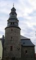
With the completion of the fortifications in 1408, Wölfersheim was granted certain privileges under the government of the last Falkensteiner , Werner von Falkenstein . Although no development into a real city took place, Wölfersheim was now referred to as a patch , fortification , oppidum or “castle”. The circular wall around the historic town center was 794 m long and had four defense towers, namely the White Tower, the Black Tower, the current church tower and the Narrenturm. The latter is now a tower stump and surrounded by a barn on private property, but is still partially visible from the outside. Further defense towers are suspected, but the existence cannot be proven. Surrounded by the wall, Wölfersheim was then four hectares in size. The good preservation of the defense towers can also be explained by their continued use. The Black Tower was used as a bell tower for the Antonius Chapel and was also the community bake house. It was expanded into a poor house in the 19th century. A private person from Dorheim converted it into a residential tower . The White Tower continued to be used as a prison in the 18th century. The northern defense tower is used as the base for the bell tower of the Evangelical Reformed Church.
- former defense towers

White Tower

Black tower
Church tower, formerly a defense tower

"Narrenturm", today a stump tower and a barn on private property.


.jpg)
Reformation in Wölfersheim
Wölfersheim was a branch of Södel until 1611 . The parish of Södel was originally owned by the Mainz diocese, which is also referred to by the St. Martin's patronage. In the 12th century, the newly founded Ilbenstadt Monastery was given property to Wölfersheim and Södel. The church in Södel was also subordinated to the monastery. The then pastor Seifried Bender introduced the Evangelical Lutheran church service in his parish in Södel in the second half of the 16th century . The exact year of the introduction of the Reformation is not known. Since Wölfersheim wanted to break away from the Södler mother church, the Wetzlar theologian Antonius Schüler was hired as a teacher in the 1560s, without asking the mother church or the Ilbenstadt monastery . Later he was also given pastoral duties. When Seifried Bender got old and sick, he asked Antonius Schüler to take over the pastoral service in Södel. After Bender's death, Valentin Textor reasserted the rights of the parish of Södel and sent Antonius students away. However, from now on, services were also held in Wölfersheim. Symon Leurelius, Textor's successor, introduced the Reformed worship in the Södel congregation. He met resistance in Södel. The court and the municipality of Södel filed a complaint with the Ilbenstadt monastery, which states:
"[...] with the guardianship of the ruling gentlemen, not only the clock-old, Christian church ceremonies, but also the catechism for themselves and specially favor mutated and changed, sometimes in matre zue Södel, sometimes in Filiali ecclesia zu Wilfersheim until still used, also the time because apud filiam and never with them toe Södel communicated and led the poor youth from the Catechismo Lutheri ad Heydelbergensem. "
The monastery then dropped Leurelius in Södel. But in 1611 he moved to Wölfersheim. The removal of the pastor in Södel and the takeover of him as pastor of Wölfersheim meant the church separation of Södel and Wölfersheim.
After Leurelius' death in January 1612, the Södlers tried to reassert their old rights. A note in the church book showing the resistance of the Wölfersheimer reads as follows:
"According to his Thoth, the Lutheran from Södel wanted to nest here, but they sold their collatures , if they had let the pious old Symon die with them, they could have walked, but the nasuti [nosy wise men] had done it, so our goodness. Mr. Gr. Wilhelm the Elder gave them an original pastor M. Eberhardum Venatorem, because the Mintzenberger pp. calvinismum [because he was a Calvinist] abolished, chosen, a very learned man. "
According to the note, the rulers then installed their own Reformed pastor (Eberhard Venator). During the Thirty Years' War , the Ilbenstadt Monastery tried a counter-reformation in Wölfersheim, but it failed.
Territorial reform
In the course of administrative reform in Hesse , the communities were voluntarily Melbach , Södel , Wohnbach and Woelfersheim to advanced community "Woelfersheim" together . Wölfersheim was designated as the administrative seat.
Territorial history and administration
The following list gives an overview of the territories in which Wölfersheim was located and the administrative units to which it was subordinate:
- before 1742: Holy Roman Empire , County Solms-Braunfels , (share in the Munzenberg rule ), Wölfersheim office
- from 1742: Holy Roman Empire, Principality of Solms-Braunfels, (share in the Munzenberg rule), Wölfersheim office
- from 1806: Grand Duchy of Hesse (through the Rhine Confederation Act ), Upper Duchy of Hesse , Wölfersheim Office (of Prince Solms-Braunfels)
- from 1815: German Confederation , Grand Duchy of Hesse, Province of Upper Hesse , Wölfersheim Office (of Prince Solms-Braunfels)
- from 1820: German Confederation, Grand Duchy of Hesse, Province of Upper Hesse, Wölfersheim Office ( Patrimonial Court: Aristocratic Office Wölfersheim of Prince Solms-Braunfels)
- from 1822: German Confederation, Grand Duchy of Hesse, Province of Upper Hesse, District District Hungen (separation between justice ( District Court Hungen ; 1822 the rights of the "civil registry office Wölfersheim" were transferred to the district court, where they were exercised on behalf of the registry lords) and administration)
- from 1841: German Confederation, Grand Duchy of Hesse, Province of Upper Hesse, District of Hungen
- from 1848: German Confederation, Grand Duchy of Hesse, Friedberg District
- from 1852: German Confederation, Grand Duchy of Hesse, Province of Upper Hesse, Friedberg District
- from 1867: North German Confederation , Grand Duchy of Hesse, Province of Upper Hesse, Friedberg District
- from 1871: German Empire , Grand Duchy of Hesse, Province of Upper Hesse, Friedberg District
- from 1874: German Empire , Grand Duchy of Hesse, Province of Upper Hesse, Friedberg District
- from 1918: German Empire, People's State of Hesse , Province of Upper Hesse, Friedberg District
- from 1945: American zone of occupation , Greater Hesse , Darmstadt administrative district, Friedberg district
- from 1949: Federal Republic of Germany , State of Hesse , Darmstadt administrative district, Friedberg district
- from 1972: Federal Republic of Germany, State of Hesse, Darmstadt district, Wetterau district
Courts since 1803
In the Landgraviate of Hesse-Darmstadt , the judicial system was reorganized in an executive order of December 9, 1803. The “Hofgericht Gießen” was set up as a court of second instance for the province of Upper Hesse . The jurisdiction of the first instance was carried out by the offices or landlords and thus from 1806 the “Patrimonial Court of the Princes Solms-Braunfels” in Wölfersheim was responsible for Wölfersheim. The court court was the second instance court for normal civil disputes, and the first instance for civil family law cases and criminal cases. The second instance for the patrimonial courts were the civil law firms. The superior court of appeal in Darmstadt was superordinate .
With the founding of the Grand Duchy of Hesse in 1806, this function was retained, while the tasks of the first instance 1821–1822 were transferred to the newly created regional and city courts as part of the separation of jurisdiction and administration. From 1822, the princes of Solms-Braunfels let the Grand Duchy of Hesse exercise their court rights on their behalf. “ Landgericht Hungen ” was therefore the name of the court of first instance that was responsible for Wölfersheim. The prince also waived his right to the second instance, which was exercised by the law firm in Hungen. It was only as a result of the March Revolution in 1848 that the special rights of the civil servants became final with the “Law on the Relationships of Classes and Noble Court Lords” of April 15, 1848 canceled.
On the occasion of the introduction of the Courts Constitution Act with effect from October 1, 1879, as a result of which the previous grand-ducal Hessian regional courts were replaced by local courts in the same place, while the newly created regional courts now functioned as higher courts, the name was changed to "Hungen Local Court" and allocation to the district of the regional court of Giessen . At the same time Wölfersheim came to the Friedberg district court . In the Federal Replica of Germany, the superordinate instances are the Regional Court of Giessen , the Higher Regional Court of Frankfurt am Main and the Federal Court of Justice as the last instance.
Population development
Source: Historical local dictionary
- 1961: 1919 Protestant (= 74.79%), 619 Catholic (= 24.12%) inhabitants
| Wölfersheim: Population from 1834 to 2015 | ||||
|---|---|---|---|---|
| year | Residents | |||
| 1834 | 825 | |||
| 1840 | 803 | |||
| 1846 | 867 | |||
| 1852 | 808 | |||
| 1858 | 843 | |||
| 1864 | 828 | |||
| 1871 | 839 | |||
| 1875 | 810 | |||
| 1885 | 872 | |||
| 1895 | 901 | |||
| 1905 | 1,051 | |||
| 1910 | 1.102 | |||
| 1925 | 1,271 | |||
| 1939 | 1,720 | |||
| 1946 | 2,394 | |||
| 1950 | 2,526 | |||
| 1956 | 2,443 | |||
| 1961 | 2,566 | |||
| 1967 | 2,919 | |||
| 1970 | 2,924 | |||
| 1972 | 7,785 | |||
| 1976 | 7,923 | |||
| 1984 | 8,065 | |||
| 1992 | 8,571 | |||
| 2000 | 9,300 | |||
| 2010 | 9,811 | |||
| 2015 | 9,900 | |||
| Data source: Historical municipality register for Hesse: The population of the municipalities from 1834 to 1967. Wiesbaden: Hessisches Statistisches Landesamt, 1968. Further sources:; 1972 :; 1976 :; 1984 :; 1992 :; 2000, 2015 :; 2010: From 1972 including the towns incorporated into Hesse as part of the regional reform . | ||||
religion
In all five districts there is an evangelical parish, in Wölfersheim an evangelical reformed parish. In addition, a Roman Catholic parish was established after 1945 , which is merged with the Catholic parish in Echzell to form a parish.
The Protestant parishes of Södel and Melbach work closely together and have a common pastor.
With the exception of the Protestant parish Wohnbach, which belongs to the Hungen dean's office, the other four Protestant parishes in the Wölfersheim parish have now joined the Wetterau Protestant dean's office.
The Catholic parish of Wölfersheim-Echzell is part of the Catholic Dean's Office Wetterau-Ost.
Jewish families lived in Wölfersheim until the expulsion and murder. The Jewish cemetery is at the northeast end of the village.
politics
Community representation
The local elections on March 6, 2016 produced the following results, compared to previous local elections:
| Parties and constituencies |
% 2016 |
Seats 2016 |
% 2011 |
Seats 2011 |
% 2006 |
Seats 2006 |
% 2001 |
Seats 2001 |
||
|---|---|---|---|---|---|---|---|---|---|---|
| SPD | Social Democratic Party of Germany | 67.3 | 21st | 60.1 | 19th | 53.3 | 17th | 52.5 | 16 | |
| CDU | Christian Democratic Union of Germany | 12.7 | 4th | 16.0 | 5 | 20.4 | 6th | 22.7 | 7th | |
| GREEN | Alliance 90 / The Greens | 6.6 | 2 | 10.0 | 3 | 8.2 | 3 | 5.8 | 2 | |
| FWG | Free voter community Wölfersheim | 13.4 | 4th | 8.2 | 2 | 7.8 | 2 | 6.9 | 2 | |
| NPD | National Democratic Party of Germany | - | - | 5.7 | 2 | 10.4 | 3 | 12.1 | 4th | |
| total | 100.0 | 31 | 100.0 | 31 | 100.0 | 31 | 100.0 | 31 | ||
| Voter turnout in% | 57.2 | 51.2 | 47.9 | 56.9 | ||||||
mayor
The past mayoral elections produced the following results:
|
|
|||||||||||||||||||||||||||||||||||||||||||||||||||||||||||||||||||||||||||||||||||||||||||||||||
Since Mayor Joachim Arnold (SPD), who has been in office since 1994, was elected district administrator of the Wetterau district in 2008, new elections were held on May 25, 2008. From these, Rouven Kötter (SPD) emerged as the new mayor with 69.5%. The turnout was 58.4%. He was confirmed in office in 2014 with 95.7% of the vote and a voter turnout of 52.9%. When Kötter switched to the regional association, new elections took place in March 2018, from which Eike See emerged as the winner with 67% of the vote and a turnout of 58.8%.
coat of arms

On a blue field is a wall with three tin towers. A falcon without claws grows out of the pinnacle wreath, above which two signs, placed side by side, hover. On the left the Trier cross , on the right the divided Falkensteinische-Münzenberg shield in red and yellow (contrary to other interpretations).
The Trier cross refers to the last local lord from the Falkenstein family, Werner von Falkenstein , who was also Archbishop of Trier. He died childless in 1418. The Wölfersheim coat of arms is inscribed with the words "Silligium opidi Wolffersheim" (seal of the city of Wölfersheim).
The Wölfersheim coat of arms was approved by the Hessian Ministry of the Interior in Wiesbaden on March 28, 1973 and is listed in the "Hessian Wappenbuch" under no. 594 and also in the collective work "German Coat of Arms Federal Republic of Germany".
After the incorporation of Södel, Melbach, Wohnbach and Berstadt through the Hessian regional reform, the coat of arms of the district of Wölfersheim was adopted for the community of the same name and the authorization to use coats of arms, official seals and any flags of the other districts has expired.
 The municipal logo shows a W, which for the first letter of W is ölfersheim, and five red dots that represent the five districts.
Community partnerships
Since 2012, there is a community partnership with the Slovak municipality Rabča . On September 6, 2014, the partnership with the French municipality of L'Isle-sur-le-Doubs was officially signed.
Culture and sights
Buildings
Evangelical Reformed Church in Wölfersheim

The Evangelical Reformed Church is the house of worship of the Evangelical Reformed community in Wölfersheim. It is one of the largest baroque hall churches in Germany and was built between 1717 and 1740.
The lower part of today's church tower used to be a defensive tower of the medieval town fortifications.

White Tower
The White Tower is the most distinctive landmark of Wölfersheim and with its height of 27 meters it was the largest structure of the Wölfersheim fortifications, completed in 1408. The tower was completed in 1408. The anniversary year 2008 was celebrated with several events and a festival weekend “600 years of the White Tower”. The original entrance is at the level of the former wall of the local fortification and is accessible again via the former community inn.
- Interior views of the White Tower

Up stairs with fire flap

Niche in the masonry with a bench

Stairs exit
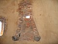
Old fireplace in the former guard room


Black tower
The square black tower was also part of the city wall. It originally had four slightly protruding round corner towers, so-called wich houses. Today he wears a baroque tower helmet.
Singberg
The then incumbent Grand Ducal Mayor Andreas Allwohn and the municipal council decided in 1855 to reclaim the previously stony, uneven and desolate piece of land. Today the Singberg has become a beautiful park with 18 tree species and around 10 shrub species, including rare shrubs and trees.
Other well-known buildings, locations and squares

in Wölfersheim:
- The linden tree in the north of the village at the intersection Wingerstr./Hauptstr./Wohnbacher Str.
- The tubular fountain in the center of Wölfersheim, another landmark next to the White Tower. It has 5 fountain outlets. To the south, one of the three Pappenheimer Höfe borders the Röhrbrunnen. The coat of arms of the von Pappenheim family is located in an outbuilding next to the entrance to the courtyard .
- The monument next to the White Tower in memory of the victims of the two world wars
- The Catholic Church "Christ the King"
- The Evangelical Reformed Church, one of the largest self-supporting hall churches in Western Europe
- The Wölfersheim-Södel train station
- The Wetterauhalle
- The Wölfersheimer See , with the still preserved cooling systems of the former power station
- Zehntscheune, (half-timbered barn)
- Old elevated drinking water reservoir on Singberg (the current elevated reservoir is on Limberg)
- Limberg, small forest west of Wölfersheim
- Historic half-timbered houses in Kirchgasse, Hollergasse and Poststrasse.
in Wohnbach:
- Evangelical Church (Wohnbach)
- Old Town Hall (Wohnbach)
- The historic rock cellars in front of the historic entrance to the town.
- The ruins of a Roman signal tower in the Wohnbach forest
- The ruins of a Roman "Villa Rustica" in the Wohnbacher Hinterwald
- A fortification from the Seven Years' War in the Bergheim Forest
Museums
- Wölfersheim Energy Museum (WEM) in Wölfersheim. The museum was set up by the association for the maintenance of the mining and power plant tradition in Wölfersheim in 1991 eV.
- Folklore Museum in Berstadt, set up by the Berstadt Village Development Working Group. It is located in the former water tower.
nature
Economy and Infrastructure

For many years, Wölfersheim and the surrounding area were shaped by lignite mining by the PreussenElektra . All around Wölfersheim, lignite was extracted in civil engineering operations and later also in open-cast mining and processed in the Wölfersheim power station , which for many years was the symbol of Wölfersheim. In 1804, the first mine was built to exploit the lignite deposits, which stretched over an area of approx. 15 km, in civil engineering. First of all, heating material was obtained. In 1913, the Hessian state built a power station to generate electricity from lignite. In 1929 it was taken over by PreussenElektra, which built a smoldering power plant. After the Second World War it was replaced by a block power station. At the beginning of the 1960s, the company switched to opencast mining. In 1991 the last lignite was burned, the power plant was shut down and later demolished. Today the remains of the cooling system in Lake Wölfersheim testify to that time. Both a coal train and an ash train are set up as museum pieces at the Wölfersheim train station . Opposite the train station, the Wölfersheim Mining Museum was opened in the former substation on March 12, 2006. It is open on Sundays from 3 to 6 p.m. and gives visitors an insight into the history of Wölfersheim mining. With the end of mining, the community faced a challenge. Numerous jobs were lost and areas lay fallow. This was counteracted with the development of an industrial park. An industrial park with a diverse mix of industries was created on the former power plant site. Particular attention was paid to the integration of existing buildings. Today, cultural events take place in a former workshop, an office building has become a service center that offers space for young companies, and high-performance scanners are now manufactured in a former magazine . In September 2012 the OVAG Group inaugurated a biogas plant in Wölfersheim-Berstadt . The OVAG Group also operates a large solar park together with the municipality. At the beginning of 2017 it was announced that food retailer REWE would like to build a distribution center for groceries called Logistikpark A45 Wölfersheim on an area of approx. 30 hectares in the Berstadt district of Wölfersheim , which will have approx. 570 employees. According to the company, construction is expected to start in March 2020. There is resistance to the project and others. a. in the form of the citizens' initiative Bürger für Boden , which regards increased overexploitation of the fertile soils of the Wetterau as a negative development.
traffic
Wölfersheim is located on the federal motorway 45 with the motorway connection Wölfersheim and the federal highways 455 and 489 . Railway stations on the Friedberg – Wölfersheim / Södel line (former Friedberg – Mücke line ) are currently still in the districts of Melbach and Wölfersheim, and previously also in Berstadt towards Wohnbach.
media
The community is located in the catchment area of the Wetterauer Zeitung . Information on current events and official announcements can be found in the community mirror, which appears every Friday. In addition, the community publishes an almost weekly vlog on YouTube.
education
The Singbergschule Wölfersheim is located in Wölfersheim. This was initially a primary and secondary school with ability level and focusing on music. From the new school year 2009/2010, it became a cooperative comprehensive school through the establishment of a grammar school branch from grade 5 ; Since the 2015/16 school year, an additional upper school level has been set up there.
The Jim Button School is located in Södel. This is a primary school . It was completed in 2004 and now offers more than 400 pupils from all parts of the town to study in twenty elementary school classes and four classes per year as well as a pre-class. The school offer is rounded off by lunch care with food.
Care facilities
The community itself has seven day-care centers that offer all-day care with lunch. The offer is supplemented by the parent-child association, which enables small children to socialize at an early stage, and child minders, whose training was promoted on the initiative of the community. Construction work is currently underway on the new “Villa Kunterbunt” daycare center and work on setting up two additional daycare centers in the former pharmacy and the “Storchennest” daycare center in Berstadt.
- Parent-child association Wölfersheim
- Day care center "Löwenzahn" in Wölfersheim
- Day care center “Villa Kunterbunt” in Wölfersheim
- Nursery "Am Weißen Turm" in Wölfersheim
- “Rainbow” day care center in Södel
- Day care center “Räuberhöhle” in Melbach
- Day care center "Dandelion" in Wohnbach
- “Wasserburg” day-care center in Berstadt
Leisure and sports facilities
Wölfersheim offers a high ropes course on Lake Wölfersheim, which was completed in summer 2008 and also contains a low rope course. In 2017, a football golf course was opened at Lake Wölfersheim.
Fun and football pitches :
- in Wölfersheim am Singberg
- in Södel next to the gym
- in Melbach at the sports field
- in Wohnbach above the gym
- in Berstadt at the multi-purpose hall
Sons and daughters of the church
- Georg Eberhard Rumpf (1627–1702), mercenary, Dutch officer and administrative officer of the VOC , botanist, naturalist and explorer, nickname Pliny Indicus
- Johann Wilhelm von Keller (1638–1698), Dutch diplomat, ambassador to Moscow , nephew of Georg Eberhard Rumpf
- Wilhelm Dorsch (1868–1939), member of the Reich and Landtag from Wölfersheim
- Joachim Arnold (* 1959), from 2008 to 2017 district administrator of the Wetterau district
literature
- Christian Aledter: The historic Wölfersheim. Vol. 1: 1128-1900. Wölfersheim 1976.
- Ernst Clotz: House, gate, bell and grave inscriptions to Wölfersheim in the Wetterau. In: Friedberger Geschichtsblätter 5 (1925).
- Friedrich Clotz: May and autumn dish at Wölfersheim. In: Friedberger Geschichtsblätter 4 (1914).
- Friedrich Clotz: Three lectures on local history. Friedberg (Hesse) 1927
- Herbert Meyer: Family Book Wölfersheim. Family book of the Protestant-Reformed parish from 1637. (Ed. Central Office for Person and Family History, Frankfurt am Main) German local clan books for person and family history. Row B Volume 233.Darmstadt 2001.
- Eugen Rieß: Brief historical outline of Wölfersheim. In: Herbert Meyer: Familienbuch Wölfersheim. Pp. 4-14.
- Eugen Rieß: 250 years of the Evangelical Reformed Church in Wölfersheim. (Ed.) Ev. Ref. Wölfersheim parish, 1991.
- Römheld: Wölfersheim in the Wetterau. In: Heimat im Bild, No. 12, 1931.
- Dieter Wolf : On the medieval fortification of villages and spots in the Wetterau - with special consideration of Rodheim vor der Höhe. In: Rodheimer Hefte No. 2, 1996, pp. 25-83. To Wölfersheim, pp. 50–53.
- Literature on Wölfersheim in the Hessian Bibliography
- Literature on Wölfersheim in the catalog of the German National Library
Web links
- Internet presence of the community of Wölfersheim
- Wölfersheim (municipality), Wetterau district. Historical local dictionary for Hessen. In: Landesgeschichtliches Informationssystem Hessen (LAGIS).
- Wölfersheim, Wetterau district. Historical local dictionary for Hessen. In: Landesgeschichtliches Informationssystem Hessen (LAGIS).
- Information on the community of Wölfersheim. In: Hessisches Gemeindelexikon. HA Hessen Agentur GmbH , 2016.
- Link catalog on the subject of Wölfersheim at curlie.org (formerly DMOZ )
Individual evidence
Christian Aledter, Chronicle Wölfersheim. Volume I from 1128 to 1900. 1976
- ↑ pp. 39-41
- ↑ p. 40
- ↑ p. 41
- ↑ p. 350, with reference to: Stadtarchiv Friedberg, Bauer, page 1
- ↑ p. 350
- ↑ p. 351, with reference to: Archiv Darmstadt Reitze, page 137
- ↑ p. 351
- ↑ p. 351
Others
- ↑ Hessian State Statistical Office: Population status on December 31, 2019 (districts and urban districts as well as municipalities, population figures based on the 2011 census) ( help ).
- ↑ Amalgamation of the communities Melbach, Södel, Wohnbach and Wölfersheim in the Friedberg district to form the community "Wölfersheim" on January 5, 1971 . In: The Hessian Minister of the Interior (Ed.): State Gazette for the State of Hesse. 1971 No. 3 , p. 110 , 110 ( online at the information system of the Hessian state parliament [PDF; 5.5 MB ]).
- ^ Federal Statistical Office (ed.): Historical municipality directory for the Federal Republic of Germany. Name, border and key number changes for municipalities, counties and administrative districts from May 27, 1970 to December 31, 1982 . W. Kohlhammer GmbH, Stuttgart / Mainz 1983, ISBN 3-17-003263-1 , p. 360 .
- ↑ Wolf Kubach: Graves between tumulus and urn field culture. The Bronze Age grave finds from Wölfersheim. In: Vera Rupp (Hrsg.): Archeology of the Wetterau. Bindernagel, Friedberg 1991, ISBN 3-87076-065-6 , pp. 175–186 (special edition of Wetterauer Geschichtsblätter 40/1991).
- ^ Manfred Stimming, Mainz document book 1 . Darmstadt 1932, No. 554, pp. 466-468.
- ↑ Peter Acht , Mainz document book 2 . 1968-1971, No. 184, pp. 342-343.
- ↑ Ludwig Clemm , The documents of the Premonstratensian donors Ober- u. Nieder-Ilbenstadt, in: Archive for Hessian History and Antiquity, NF 14, 1925, pp. 129–223, 15, 1928, pp. 147–224, here vol. 14, no. 21, pp. 141–142.
- ^ Document book Fulda, 510.
- ↑ Heinrich Meyer to Ermgassen: The Codex Eberhardi the monastery of Fulda . Vol. 1. 1995, p. 333 = Ernst Friedrich Johann Dronke , Traditiones Antiquitates Fuldensis (TAF), Capitulum 25, p. 60.
- ^ G. Behrens, Franconian graves of the 7th century from Hesse. in: Germania 21, 1937, pp. 267-272.
- ↑ Jürgen Steen, Royalty and Nobility in the Early Medieval Settlement, Social and Agricultural History in the Wetterau. Studies on the relationship between land acquisition and continuity using the example of a peripheral landscape of the Merovingian Empire . Frankfurt am Main 1979, p. 168 f.
- ↑ The information on the church's website is incorrect!
- ↑ Wetterauer Zeitung of April 17, 2008, p. 30, article: From the small settlement to the "Minor town"
- ↑ 20 guilders
- ^ Eugen Rieß: 250 years of the Evangelical Reformed Church in Wölfersheim. P. 52/53, publisher: ev.-ref. Parish Wölfersheim
- ^ Eugen Rieß: 250 years of the Evangelical Reformed Church in Wölfersheim. P. 54.
- ↑ Amalgamation of the communities Melbach, Södel, Wohnbach and Wölfersheim in the Friedberg district to form the community "Wölfersheim" on January 5, 1971 . In: The Hessian Minister of the Interior (ed.): State Gazette for the State of Hesse. 1971 No. 3 , p. 110 , point 110 ( online at the information system of the Hessian state parliament [PDF; 5.5 MB ]).
- ↑ a b c Wölfersheim, Wetteraukreis. Historical local dictionary for Hessen. (As of April 17, 2018). In: Landesgeschichtliches Informationssystem Hessen (LAGIS).
- ^ Michael Rademacher: German administrative history from the unification of the empire in 1871 to the reunification in 1990. State of Hesse. (Online material for the dissertation, Osnabrück 2006).
- ↑ Wilhelm von der Nahmer: Handbuch des Rheinischen Particular-Rechts: Development of the territorial and constitutional relations of the German states on both banks of the Rhine: from the first beginning of the French Revolution up to the most recent times . tape 3 . Sauerländer, Frankfurt am Main 1832, OCLC 165696316 , p. 21, 438 ( online at google books ).
- ↑ Latest countries and ethnology. A geographical reader for all stands. Kur-Hessen, Hessen-Darmstadt and the free cities. tape 22 . Weimar 1821, p. 424 ( online at Google Books ).
- ^ Georg W. Wagner: Statistical-topographical-historical description of the Grand Duchy of Hesse: Province of Upper Hesse . tape 3 . Carl Wilhelm Leske, Darmstadt 1830, p. 135 ( online at Google Books ).
- ↑ Theodor Hartleben (Ed.): General German Justice, Camera and Police Fama, Volume 2, Part 1 . Johann Andreas Kranzbühler, 1832, p. 271 ( online at Google Books ).
- ↑ Law on the Conditions of the Class Lords and Noble Court Lords of August 7, 1848 . In: Grand Duke of Hesse (ed.): Grand Ducal Hessian Government Gazette. 1848 no. 40 , p. 237–241 ( online at the information system of the Hessian state parliament [PDF; 42,9 MB ]).
- ^ Ordinance on the implementation of the German Courts Constitution Act and the Introductory Act to the Courts Constitution Act of May 14, 1879 . In: Grand Duke of Hesse and the Rhine (ed.): Grand Ducal Hessian Government Gazette. 1879 no. 15 , p. 197–211 ( online at the information system of the Hessian state parliament [PDF; 17.8 MB ]).
- ^ Local elections 1972; Relevant population of the municipalities on August 4, 1972 . In: The Hessian Minister of the Interior (ed.): State Gazette for the State of Hesse. 1972 No. 33 , p. 1424 , point 1025 ( online at the information system of the Hessian state parliament [PDF; 5.9 MB ]).
- ↑ Local elections 1977; Relevant population figures for the municipalities as of December 15, 1976 . In: The Hessian Minister of the Interior (ed.): State Gazette for the State of Hesse. 1976 No. 52 , p. 2283 , point 1668 ( online at the information system of the Hessian state parliament [PDF; 10.3 MB ]).
- ^ Local elections 1985; Relevant population of the municipalities as of October 30, 1984 . In: The Hessian Minister of the Interior (ed.): State Gazette for the State of Hesse. 1984 No. 46 , p. 2175 , point 1104 ( online at the information system of the Hessian state parliament [PDF; 5.5 MB ]).
- ↑ local elections 1993; Relevant population of the municipalities as of October 21, 1992 . In: The Hessian Minister of the Interior (ed.): State Gazette for the State of Hesse. 1992 No. 44 , p. 2766 , point 935 ( online at the information system of the Hessian state parliament [PDF; 6.1 MB ]).
- ↑ Community data sheet : Wölfersheim. (PDF; 222 kB) In: Hessisches Gemeindelexikon. HA Hessen Agency GmbH
- ↑ The population of the Hessian communities on June 30, 2010. (PDF; 552 kB) Hessisches Statistisches Landesamt, p. 11 , archived from the original on February 7, 2018 ; accessed on March 20, 2018 .
- ↑ Eugen Rieß, possibly ref. Wölfersheim Church, pp. 135–138.
- ^ Result of the municipal election on March 6, 2016. Hessian State Statistical Office, accessed in April 2016 .
- ^ Hessian State Statistical Office: Result of the municipal elections on March 27, 2011
- ^ Hessian State Statistical Office: Result of the municipal elections on March 26, 2006
- ^ Election results on the municipality's website. Accessed August 31, 2018 .
- ^ Sister towns of the community of Wölfersheim
- ↑ 'French flair in Wölfersheim' on woelfersheim.de, September 8, 2014
- ↑ Book: 250 Years of Evangelical Reformed Church Wölfersheim, p. 9, Festschrift from May 22, 1991 by Eugen Rieß, editor: ev.-ref. Parish Wölfersheim
- ↑ A short guide: Evangelical Reformed Church Wölfersheim ( Memento of the original from April 2, 2015 in the Internet Archive ) Info: The archive link was automatically inserted and not yet checked. Please check the original and archive link according to the instructions and then remove this notice. , by Kathrin Ellwardt, Marburg, March 1994
- ↑ Michel Kaufmann: Rewe is building a huge distribution center for groceries in Wölfersheim. In: Gießener Anzeiger . Gießener Anzeiger Verlags GmbH & Co KG, February 8, 2017, accessed on April 12, 2019 .
- ↑ Rewe: Timeline. REWE Markt GmbH, accessed on April 12, 2019 .
- ↑ Citizens for soil: Our goals: To inform, educate, raise awareness and protest. BI Citizens for Soil, accessed April 12, 2019 .
- ↑ [1]
- ^ Community board of the community Wölfersheim: Community Wölfersheim - Home. Retrieved October 2, 2017 .

Altenstadt | Bad Nauheim | Bad Vilbel | Büdingen | Butzbach | Echzell | Florstadt | Friedberg (Hesse) | Gedern | Glauburg | Hirzenhain | Karben | Kefenrod | Limeshain | Munzenberg | Nidda | Niddatal | Ober-Mörlen | Ortenberg | Ranstadt | Reichelsheim (Wetterau) | Rockenberg | Rosbach v. d. Height | Wölfersheim | Wöllstadt