
Wetterau Lake District

The Wetterau Lake District is a lake district , i.e. a group of lakes and ponds , in the Horloffsenke ( natural area 234.0), part of the Wetterau in Hesse .
Emergence
The lakes of the Wetterau Lake District are not of natural origin. These are opencast mining lakes that were created during the recultivation of opencast mines in the Wetterau lignite mining area. Some smaller ponds are sinking ponds from the time of underground lignite mining, that is, day breaks from collapsed underground cavities that have been filled with water .
Regional park project
The Lake District is intended as an independent project in the Regional Park Rhein-Main of the Planning Association Rhein-Main are developed. For this purpose, the municipalities of Wölfersheim , Reichelsheim , Echzell and Hungen founded a formal working group in early 2008 .
In the areas of recreation , sport , landscape art , preservation of cultural heritage and nature conservation , the cities want to cooperate in order to improve the quality of life, the residential and leisure value of the region, to make it more attractive for tourism and thus also to promote it economically. Various nature and adventure trails, museums and an information center are to be created for visitors to the region . Furthermore, a connection to supra-regional cycling and hiking trails such as the Niddaradweg or the Vulkanradweg as well as themed roads such as the German Limes Road is planned.
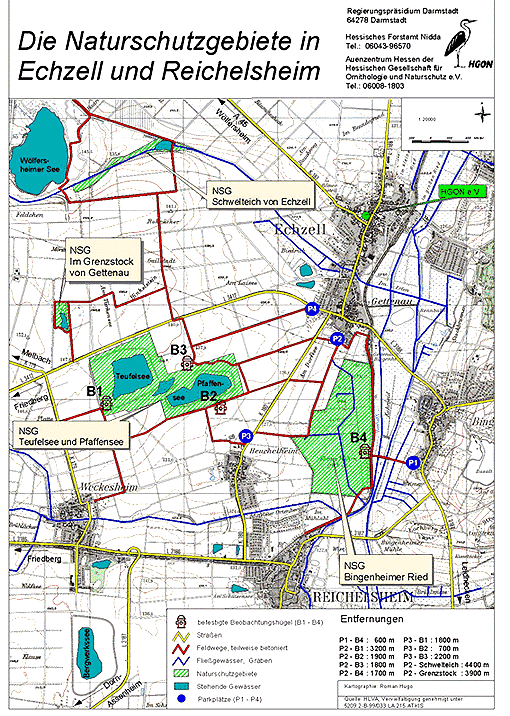
Nature and bird protection
The valley landscape of the Horloff with its floodplains is particularly valuable for bird protection as a breeding and resting area.
The regional park project is to be closely interlinked with the Wetterau floodplain network. In this protected landscape area of around 7,400 hectares, which was designated in 1989, more than 30 smaller and larger nature reserves with an area of around 1,400 hectares are embedded. This also includes several of the Wetterau lakes (see table below). The Auenverbund project was awarded the European Environment Prize in 1988 , is part of the Natura 2000 program and is registered as a European bird sanctuary .
Cycling and walking
On the occasion of the state horticultural show in Bad Nauheim in 2010, the four municipalities published a cycling map with two tour suggestions. The card is available free of charge in the town halls of the municipalities. In 2017 there was a new edition with improved cartography, which is also available free of charge in town halls.
Lakes and ponds
| lake | size | location | coordinate | Open pit | Open pit mining | Use today |
|---|---|---|---|---|---|---|
|
Trais-Horloffer See (also Inheidener See ) |
35.1 ha | between Inheiden and Trais-Horloff | 50 ° 27 '6.6 " N , 8 ° 54' 18.4" E | Inheiden opencast mine | 1918-38 1938-50 |
Bathing and water sports |
|
Sachsensee (also Barbarasee ) |
approx. 35 ha | southeast of Bellersheim | 50 ° 26 '48.1 " N , 8 ° 51' 23.8" E | Open pit mine I | 1961-75 | Local recreation , fishing pond |
| Upper Knappensee | 36.3 ha | northeast of Utphe | 50 ° 26 '30 " N , 8 ° 53' 39.4" E | Opencast mine IV (opencast mine Utphe) |
1974-84 | |
| Lower Knappensee | approx. 32 ha | southeast of Utphe | 50 ° 25 '51 " N , 8 ° 53' 30.5" E | Nature reserve ("Mittlere Horloffaue") |
||
| Wölfersheimer See | 38 ha | east of Wölfersheim | 50 ° 23 '48.7 " N , 8 ° 50' 14.3" E | Wölfersheim opencast mine | 1927-43 | Local recreation, fishing |
| Heldtteich | approx. 1 ha | northeast of Wölfersheim | 50 ° 24 '18.5 " N , 8 ° 50' 32.8" E | |||
| - | <1 ha | southeast of Wölfersheim | 50 ° 22 '52.8 " N , 8 ° 50' 25.1" E | Nature reserve ("Im Grenzstock von Gettenau") |
||
| Stately pond (also smoldering pond ) |
<1 ha | east of Wölfersheim, northwest of Echzell |
50 ° 23 '53.2 " N , 8 ° 51' 20.1" E | no open pit residual lake | - | Nature reserve ("Schwelteich von Echzell") |
| Teufelsee | approx. 25 ha each | north of Weckesheim , northwest of Heuchelheim |
50 ° 22 '35.6 " N , 8 ° 50' 59.4" E | Opencast mine II / III (Heuchelheim opencast mine) |
1962-89 | Nature reserve ("Pfaffensee and Teufelsee") |
| Pfaffensee | 50 ° 22 '30.1 " N , 8 ° 51' 41.4" E | |||||
| Gettenau pond (s) | approx. 1.2 ha | west of Gettenau | 50 ° 23 '9.7 " N , 8 ° 52' 35.8" E | Fishing, biotope | ||
| Heuchelheimer ponds | <1 ha | Western outskirts of Heuchelheim | 50 ° 22 '0.6 " N , 8 ° 51' 45.6" E | Clarification ponds for wastewater from the plant Tgb. II / III | ||
| Reichelsheim pond (s) | approx. 1 ha | South-western outskirts of Reichelsheim | 50 ° 21 '21.1 " N , 8 ° 51' 58.7" E | Open pit VI / Absinkteich | 1983-89 | |
| (Reichelsheimer) mining lake | approx. 30 ha | north of Dorn-Assenheim | 50 ° 20 '59.8 " N , 8 ° 50' 39.6" E | Opencast mine VII | 1988-91 | Concept in planning |
| Weckesheimer pond (also Leonhard pond ) |
approx. 1 ha | South-eastern outskirts of Weckesheim | 50 ° 21 '29.3 " N , 8 ° 50' 45.9" E | Local recreation, fishing |
Web links
Individual evidence
- ↑ PreussenElektra: Overview map of the opencast mining operations , online at www.alexanderhitz.de ( Memento of the original from February 3, 2015 in the Internet Archive ) Info: The archive link was inserted automatically and has not yet been checked. Please check the original and archive link according to the instructions and then remove this notice.
- ↑ a b Mayors launch the “Wetterauer Seenplatte” - press release on www.woelfersheim.de (PDF)
- ↑ a b c d Hessian Society for Ornithology and Nature Conservation: The nature reserves in Echzell and Reichelsheim (map), online at www.norbert-kuehnberger.de
- ↑ Thomas Brandt, Christoph Moning and Christian Wagner: The Horloffaue between Hungen and Reichelsheim in Hesse - water birds in the Wetterau northeast of Frankfurt . In: Der Falke - Journal für Vogelbeobachter , 2/2009, online at www.schattenblick.de
- ↑ http://wetterauer-seenplatte.de/index.php/freizeit/radfahren
- ^ Community of Wölfersheim: Explore the Wetterau lake landscape better. Wölfersheim community, November 16, 2017, accessed on August 31, 2018 .
- ↑ Der Inheidener See: Remnants of the Friedrich union on www.alexanderhitz.de ( Memento of the original from February 2, 2015 in the Internet Archive ) Info: The archive link was inserted automatically and has not yet been checked. Please check the original and archive link according to the instructions and then remove this notice.
- ↑ The Utpher Seenplatte: Oberer and Unterer Knappensee on www.alexanderhitz.de ( Memento of the original from February 3, 2015 in the Internet Archive ) Info: The archive link has been inserted automatically and has not yet been checked. Please check the original and archive link according to the instructions and then remove this notice.
- ↑ NSG Mittlere Horloffaue - Oberer and Unterer Knappensee on www.norbert-kuehnberger.de
- ↑ Page no longer available , search in web archives: Hessian Society for Ornithology and Nature Conservation: The “Untere Knappensee” in the “Mittlere Horloffaue” nature reserve at www.hgon.de (PDF)
- ↑ Pfaffensee and Teufelsee at www.nabu-bingenheim.de
- ↑ NSG Pfaffensee and Teufelsee at www.norbert-kuehnberger.de
- ↑ Pflug, W .: The Wetterau brown coal area . in: Opencast lignite mining and recultivation , Springer, Berlin a. a., 1998. Quoted in: Brigitte Nixdorf et al .: Braunkohletagebauseen in Germany ( Memento of the original from September 2, 2011 in the Internet Archive ) Info: The archive link was inserted automatically and not yet checked. Please check the original and archive link according to the instructions and then remove this notice. (PDF; 14.0 MB), BTU Cottbus
- ↑ The Bergwerksee on www.alexanderhitz.de ( Memento of the original from August 26, 2013 in the Internet Archive ) Info: The archive link was inserted automatically and has not yet been checked. Please check the original and archive link according to the instructions and then remove this notice.