Saône (Doubs)
| Saone | ||
|---|---|---|

|
|
|
| region | Bourgogne-Franche-Comté | |
| Department | Doubs | |
| Arrondissement | Besançon | |
| Canton | Besançon-5 | |
| Community association | Grand Besançon | |
| Coordinates | 47 ° 13 ' N , 6 ° 7' E | |
| height | 370-495 m | |
| surface | 20.55 km 2 | |
| Residents | 3,375 (January 1, 2017) | |
| Population density | 164 inhabitants / km 2 | |
| Post Code | 25660 | |
| INSEE code | 25532 | |
| Website | www.saone.fr | |
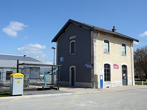
 Railway station in Saône |
||
Saône is a French commune with 3,375 inhabitants (as of January 1 2017) in Doubs in the region Bourgogne Franche-Comté .
geography
Saône is located at 397 m , about seven kilometers east-southeast of the city of Besançon (as the crow flies). The village extends in the western Jura , on the so-called first plateau on the eastern edge of the Marais de Saône marshland, between the heights of the Jura ridge in the north and the Grand Mont in the south.
The area of the 20.55 km² municipality covers a section of the western French Jura. The main part of the area is taken up by the wide first Jura plateau, which is an average of 400 m. It forms a wide basin with no above-ground drainage. This depression is mainly made up of meadow and arable land, partly also of forest. In the west, Saône has a share of the Marais de Saône , which is fed by several sources. The bog on the drained sip hole of Creux sous Roche on the southwestern outskirts. After prolonged rainfall or melting snow, the Creux sous Roche is unable to drain off enough water, so that a lake is formed in the Marais de Saône.
To the north, the municipal area extends to the foot of the Jura ridge below the height of Montfaucon, which connects to the Doubstal to the south . In the south, the plateau rises slightly in the Le Grand Frêne forest area . At 495 m, the highest point of the Saône is reached on the southern edge of the municipality.
In addition to the actual village, the Saône also includes various other settlements, hamlets and individual farms, including:
- Petit Saône ( 398 m ) on the southwestern outskirts
- Grange Fauconnière ( 417 m ) on the plateau south of the forest of Grand Frêne
Neighboring municipalities of Saône are Montfaucon and Gennes in the north, La Chevillotte and Mamirolle in the east, Le Gratteris and Tarcenay-Foucherans in the south and La Vèze and Morre in the west.
history
Saône is first mentioned in a document in 1130 under the name Sauna . Over time, the spelling changed via Sône (1249) and Sosne to today's Saône. The name is probably of Celtic origin and goes back to the word stems sag- (holy) and onna (water). In the Middle Ages, Saône was part of the Montfaucon dominion. Together with Franche-Comté , it came to France with the Peace of Nijmegen in 1678.
Attractions
The village church of Saint-Victor in Saône was completed in 1779; while the rectory dates from around 1700. Various farmhouses in the characteristic style of Franche-Comté from the 17th to 19th centuries have been preserved in the town center.
population
With 3375 inhabitants (as of January 1, 2017), Saône is one of the medium-sized municipalities in the Doubs department. After the population in the first half of the 20th century had always been in the range of around 570 people, a striking population growth has been recorded since the beginning of the 1950s. Since then the number of inhabitants has increased more than fivefold. Numerous new single and multi-family houses were built outside the old town center.
| Population development | ||||||||
|---|---|---|---|---|---|---|---|---|
| year | 1962 | 1968 | 1975 | 1982 | 1990 | 1999 | 2009 | 2016 |
| Residents | 942 | 1341 | 1943 | 2200 | 2412 | 2728 | 3225 | 3361 |
Economy and Infrastructure
Until well into the 20th century, Saône was predominantly a village characterized by agriculture (arable farming, fruit growing and cattle breeding) and forestry. Since the 1970s, industrial and commercial zones have developed on the outskirts and the convenient location near the train station and at the junction of the main road N57. Various companies from the plastics processing, construction and transport industry, wood processing, mechanical workshops and service companies have settled here. In the meantime, the village has also turned into a residential community. Many workers are commuters who work in the nearby agglomeration of Besançon. Saône is the location of a college.
The village is well developed in terms of traffic. It is close to the four-lane main road N57, which leads from Besançon to Pontarlier . There are other road connections with Montfaucon, Ornans , Mamirolle and Naisey. Saône has a train station on the railway line from Besançon to Le Locle . Mostly in the municipality of Saône, but closer to the town of La Vèze, is the Besançon-La Vèze aerodrome.
Community partnerships
Saône has been in partnership with the German municipality of Heckendalheim in Saarland since 1971 and with the Italian municipality of Piteglio in Tuscany since 1995 .
Personalities
Robert Simon (1913–2000) was a pastor in Saône, who earned money for projects in his parish by organizing tower jumps .

