Thoraise
| Thoraise | ||
|---|---|---|
|
|
||
| region | Bourgogne-Franche-Comté | |
| Department | Doubs | |
| Arrondissement | Besançon | |
| Canton | Besançon-6 | |
| Community association | Grand Besançon | |
| Coordinates | 47 ° 10 ' N , 5 ° 54' E | |
| height | 222-411 m | |
| surface | 3.99 km 2 | |
| Residents | 362 (January 1, 2017) | |
| Population density | 91 inhabitants / km 2 | |
| Post Code | 25320 | |
| INSEE code | 25561 | |
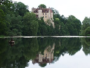
 Castle of Thoraise |
||
Thoraise is a French municipality with 362 inhabitants (as of January 1 2017) in Doubs in the region Bourgogne Franche-Comté .
geography
Thoraise is located at 250 m , about twelve kilometers southwest of the city of Besançon (beeline). The village extends on the western edge of the Jura , on a rocky promontory around which the Doubs flows in a wide loop, at the northwest foot of the Mont .
The area of the 3.99 km² large municipality covers a section of the western French Jura. The western and northern borders run along the Doubs, which flows here through a wide valley and draws a large arc to the north around the Thoraise promontory. This protrusion rises around 20 to 30 m above the valley floor and is connected in the southeast with the height of the Mont , which in geological and tectonic terms belongs to the system of the Jura ridge. On the wooded mountain, on its steep northeast slope facing the Doubs, also crossed by limestone cliffs, the highest elevation of Thoraise is reached at 411 m. The Canal Monsieur , a section of the Rhine-Rhône Canal , cuts off the Thoraise river bend and tunnels under the mountain promontory.
Neighboring municipalities of Thoraise are Grandfontaine and Montferrand-le-Château in the north, Busy and Vorges-les-Pins in the east, Boussières in the south and Torpes in the west.
history
The municipality of Thoraise was settled very early. Remains from the Gallo-Roman era have been found, including wall foundations, mosaics, coins and ceramic fragments from the 2nd century. The Lord of Montferrand founded the castle and the Thoraise estate for one of his sons in the middle of the 13th century. Over time, the rulership belonged to the Achey and Grammont families before it came to the state during the French Revolution . Together with Franche-Comté , Thoraise finally came to France with the Peace of Nijmegen in 1678.
Attractions
- The village church of Thoraise was built in the 18th century.
- The 13th century castle has been restored and has two towers.
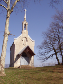
- On the heights of the Mont is the Notre-Dame du Mont chapel (18th century), from which there is a beautiful view of the Doube valley.
population
| Population development | |
|---|---|
| year | Residents |
| 1962 | 152 |
| 1968 | 165 |
| 1975 | 153 |
| 1982 | 189 |
| 1990 | 249 |
| 1999 | 239 |
| 2005 | 283 |
| 2016 | 358 |
With 362 inhabitants (as of January 1, 2017) Thoraise is one of the small communities in the Doubs department. After the population had decreased in the first half of the 20th century (210 people were still counted in 1896), a significant increase in population has been recorded since the mid-1970s.
Economy and Infrastructure
Until well into the 20th century, Thoraise was a village dominated by agriculture (arable farming, fruit growing and dairy farming). In addition, there are now some local small businesses. In the meantime, the village has also turned into a residential community. Many workers are commuters who work in the larger towns in the area.
The village is located off the major thoroughfares on a departmental road that leads from Besançon to Byans-sur-Doubs. The closest connection to the A36 motorway is around eleven kilometers away.

