
Miserey Salines
| Miserey Salines | ||
|---|---|---|
.svg)
|
|
|
| region | Bourgogne-Franche-Comté | |
| Department | Doubs | |
| Arrondissement | Besançon | |
| Canton | Besançon-3 | |
| Community association | Grand Besançon | |
| Coordinates | 47 ° 17 ′ N , 5 ° 58 ′ E | |
| height | 268-385 m | |
| surface | 6.22 km 2 | |
| Residents | 2,502 (January 1, 2017) | |
| Population density | 402 inhabitants / km 2 | |
| Post Code | 25480 | |
| INSEE code | 25381 | |

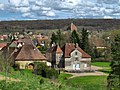
Miserey-Salines is a French commune with 2,502 inhabitants (as of January 1 2017) in Doubs in the region Bourgogne Franche-Comté .
geography
Miserey-Salines is located at 285 m , about seven kilometers northwest of the city of Besançon (as the crow flies). The village extends in the gently undulating landscape between the rivers of Doubs (in the south) and Ognon (in the north), in a valley basin on the western edge of the ridge of the Grande Côte.
The area of the 6.22 km² large municipal area includes a section south of the Ognon. The central part of the area is occupied by a basin which topographically belongs to the catchment area of the Ruisseau des Moulins (tributary of the Ognon), but which is drained underground. This small basin is surrounded by forest hills, which usually reach 300 to 320 m. To the east, the community area extends to the western foothills of the Grande Côte ridge , on which the highest elevation of Miserey-Salines is reached at 385 m. The southern border is marked by the A36 motorway.
Neighboring municipalities of Miserey-Salines are Les Auxons in the north, Châtillon-le-Duc in the east, École-Valentin and Pirey in the south and Pouilley-les-Vignes in the west.
history
Miserey is first mentioned in a document in 1149 under the name Misere . In the Middle Ages, the village was under the sovereignty of Besançon. Together with Franche-Comté , it finally came to France with the Peace of Nijmegen in 1678. With the discovery of a layer of salt up to 55 m thick in 1866, salt mining began in the following years. The Miserey saltworks were in operation until 1967. To avoid confusion with other communities of the same name, Miserey was officially renamed Miserey-Salines in 1922.
Attractions
The Saint-Ferréol-et-Ferjeux chapel was built between 1720 and 1730. It has important painted wooden statues from the 16th century and a gilded altar from the 18th century. The castle dates from the 16th century and was redesigned in the 18th century and given a square tower in 1910.

Saint-Ferréol-et-Ferjeux chapel
Miserey Castle


population
| Population development | |
|---|---|
| year | Residents |
| 1962 | 435 |
| 1968 | 448 |
| 1975 | 957 |
| 1982 | 1326 |
| 1990 | 2096 |
| 1999 | 2157 |
| 2016 | 2442 |
With 2502 inhabitants (as of January 1, 2017) Miserey-Salines is one of the medium-sized communities in the Doubs department. After the population in the first half of the 20th century had always been in the range between 320 and 500 people, a striking population growth has been recorded since the beginning of the 1960s. Since then the number of inhabitants has increased more than fivefold.
Economy and Infrastructure
Miserey-Salines was a village dominated by agriculture (arable farming, fruit growing and cattle breeding) until the 20th century. Salt mining also played an important role. Since the 1970s, a commercial and industrial zone has developed south of the village along the motorway, which extends to the municipal areas of École-Valentin and Châtillon-le-Duc with its approximately 70 hectares. Numerous companies in the transport, metal processing, mechanical workshops and women's and men's clothing industries have settled here. There are also various retail businesses and some trading companies.
The village is very well developed in terms of traffic. It is close to the main road N57 that goes from Besançon to Vesoul . The next connection to the A36 motorway , which affects the municipality, is about three kilometers away. Further road connections exist with École-Valentin, Pelousey, Auxon-Dessous and Auxon-Dessus .
The municipality is crossed by the Besançon-Viotte-Vesoul railway line . It was planned to build a breakpoint ⊙ on the western edge of the community, at the former train station, by the end of 2013 . This should have two 120 m long platforms. In addition, 30 parking spaces and a bicycle shelter are to be built. A bus line should approach the train station. [outdated]
Individual evidence
- ↑ Document on the construction of the new stops with maps (PDF; 688 kB, French).