Bouclans
| Bouclans | ||
|---|---|---|
|
|
||
| region | Bourgogne-Franche-Comté | |
| Department | Doubs | |
| Arrondissement | Besançon | |
| Canton | Baume-les-Dames | |
| Community association | Portes du Haut-Doubs | |
| Coordinates | 47 ° 15 ' N , 6 ° 14' E | |
| height | 397-514 m | |
| surface | 24.34 km 2 | |
| Residents | 1,073 (January 1, 2017) | |
| Population density | 44 inhabitants / km 2 | |
| Post Code | 25360 | |
| INSEE code | 25078 | |
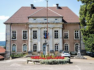
 Mairie Bouclans |
||
Bouclans is a French commune with 1,073 inhabitants (at January 1, 2017) in the department of Doubs in the region Bourgogne Franche-Comté . It belongs to the arrondissement of Besançon and the canton of Baume-les-Dames .
It was created with effect from January 1, 2018 as the Commune nouvelle of the same name through the amalgamation of the formerly independent communities of Bouclans and Vauchamps . In the new municipality, only Vauchamps has the status of a Commune déléguée . The administrative headquarters are in Bouclans.
structure
| District | former INSEE code |
Area (km²) |
Altitude (m) |
Population as of January 1, 2017 |
Density (inh. Per km²) |
|---|---|---|---|---|---|
| Bouclans (administrative headquarters) | 25078 | 21.40 | 397-514 | 953 | 44.5 |
| Vauchamps | 25587 | 2.94 | 394-457 | 126 | 42.9 |
geography
Bouclans is located at 439 m , about 16 km east of the city of Besançon (as the crow flies). It extends in the western Jura , in the middle of the so-called first plateau, a wide basin between the heights of the Jura ridge (Côte) in the north and the Côte d'Anroz in the south, on the Ruisseau du Gour. The area with hardly any relief is taken up by the broad first Jura plateau, which averages 440 m. It forms a wide basin with no above-ground drainage. There are several springs near Bouclans, the water of which joins the Ruisseau du Gour . After a short walk, the north-flowing stream drains away at the foot of the Côte. In the area of Bouclans, the plateau is predominantly made up of arable and meadow land. To the south of the village there are large forests, namely the Bois de Boille and the Forêt de Chauley (also called Forêt de Bouclans ). In the southeast the community area extends over the plateau to the foot of the adjacent heights. The highest point of bouclans is reached here at 514 m.
Neighboring municipalities of Bouclans are Osse and Champlive in the north, Glamondans and Gonsans in the east, Naisey-les-Granges in the south and La Chevillotte and Nancray in the west.
Attractions
The classicist construction of the Saint-Léger church began in 1775. Other sacred buildings include the Notre-Dame de l'Étang chapel and the cemetery chapel. Two towers, a round tower and a pentagonal keep, have been preserved from the originally medieval castle. The new rectangular castle was built in the 19th century. A manor house in the Louis XIII style (1666) has also been preserved.
Economy and Infrastructure
Until well into the 20th century, Bouclans was a village dominated by agriculture (arable farming, fruit growing and cattle breeding) and forestry. The hydropower of the Ruisseau du Gour was previously used to operate mills. In addition, there are now some local small businesses, including mechanical workshops, other handicraft businesses and various retail shops. In the meantime, Bouclans has also turned into a residential community. Many workers are commuters who work in the Besançon agglomeration.
The municipality is located off the major thoroughfares on a departmental road that leads from Besançon to Sancey-le-Grand . Further road connections exist with Osse, Champlive and Naisey.
Web links
Individual evidence
- ↑ Decree of the Prefecture No. 25-2017-09-21-045 on the formation of the Commune nouvelle Bouclans of September 21, 2017.
- ↑ current population according to INSEE
