Pelousey
| Pelousey | ||
|---|---|---|
|
|
||
| region | Bourgogne-Franche-Comté | |
| Department | Doubs | |
| Arrondissement | Besançon | |
| Canton | Besançon-2 | |
| Community association | Grand Besançon | |
| Coordinates | 47 ° 17 ' N , 5 ° 55' E | |
| height | 215-313 m | |
| surface | 6.18 km 2 | |
| Residents | 1,527 (January 1, 2017) | |
| Population density | 247 inhabitants / km 2 | |
| Post Code | 25170 | |
| INSEE code | 25448 | |
| Website | www.pelousey.com | |
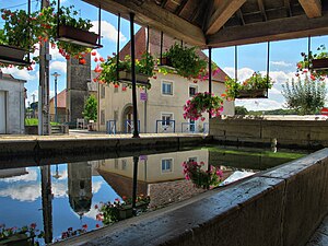
 Lavoir in Pelousey |
||
Pelousey is a French commune with 1,527 inhabitants (as of January 1 2017) in Doubs in the region Bourgogne Franche-Comté .
geography
Pelousey is located at 240 m , about nine kilometers west-northwest of the city of Besançon (as the crow flies). The village extends in the basin of the Noue in the gently undulating landscape between the rivers of Doubs in the south and Ognon in the north.
The area of the 6.18 km² municipal area includes a section south of the Ognon. The central part of the area is occupied by the Noue basin. This flows to the west and flows below the village into the lantern , which feeds its water to the Ognon. A section of this wide valley floor, as well as the neighboring forest area Bois du Chanois to the west, belongs to Pelousey. In the north-west the border runs in the area of the Talenge at Château d'Uzel. To the north and east, the community area extends into the gently undulating landscape between the Doubs and Ognon, which is partly made up of arable land and meadow, partly with forest. The area extends in the north to the Bois du Grand Bugnoz and in the east to the foot of the Mont . At 313 m, the highest point of Pelousey is reached on a hill east of the village.
The hamlet of Barband ( 260 m ) in the valley of the Noue belongs to Pelousey . Neighboring communities of Pelousey are Moncley and Les Auxons in the north, Pouilley-les-Vignes in the east and south and Chaucenne in the west.
history
Pelousey is mentioned for the first time in 1153 under the name Polosel . The place name originally comes from the Celtic and means something like wild plum . Together with Franche-Comté , the village finally came to France with the Peace of Nijmegen in 1678.
Attractions
The Saint-Martin church originally dates from the 12th century, but has been extensively restored and redesigned several times over the course of time, so that its current shape goes back to a renovation between 1757 and 1760. The Château d'Uzel, which was built at the beginning of the 17th century and later changed, is in an elevated position on the edge of the Lanterne valley. There is also a modern chapel (1960–1965). Today the castle houses a so-called Center d'aide par le travail (CAT), in which disabled people are helped to integrate into society and work.
population
| Population development | |
|---|---|
| year | Residents |
| 1962 | 230 |
| 1968 | 242 |
| 1975 | 425 |
| 1982 | 534 |
| 1990 | 902 |
| 1999 | 1215 |
| 1999 | 1511 |
With 1527 inhabitants (as of January 1, 2017) Pelousey is one of the medium-sized municipalities in the Doubs department. After the population had decreased in the first half of the 20th century (441 people were still counted in 1891), a marked increase in population has been recorded since the early 1960s. Since then, the population has increased almost sevenfold.
Economy and Infrastructure
Until well into the 20th century, Pelousey was a village dominated by agriculture (arable farming, fruit growing and cattle breeding). The hydropower of the lantern was used to operate a mill in the 19th century. Today there are various small and medium-sized businesses. A commercial zone has developed in the Lanterne Valley since the 1970s. Companies in the plastics processing, manufacture of watch straps and printing industries have settled here. In the meantime, the village has also turned into a residential community. Many workers are therefore commuters who go to work in the Besançon agglomeration.
The village is located off the main thoroughfares on a departmental road that leads from Pouilley-les-Vignes to Émagny. The nearest connection to the A36 motorway , which crosses the municipality, is approximately seven kilometers away. Further road connections exist with Noironte, Auxon-Dessous and Miserey-Salines.
