
Nambu line
| Nambu line | |||||||||||||||||||||||||||||||||||||||||||||||||||||||||||||||||||||||||||||||||||||||||||||||||||||||||||||||||||||||||||||||||||||||||||||||||||||||||||||||||||||||||||||||||||||||||||||||||||||||||||||||||||||||||||||||||||||||||||||||||||||||||||||||||||||||||||||||||||||||||||||||||||||||||||||||||||||||||||||
|---|---|---|---|---|---|---|---|---|---|---|---|---|---|---|---|---|---|---|---|---|---|---|---|---|---|---|---|---|---|---|---|---|---|---|---|---|---|---|---|---|---|---|---|---|---|---|---|---|---|---|---|---|---|---|---|---|---|---|---|---|---|---|---|---|---|---|---|---|---|---|---|---|---|---|---|---|---|---|---|---|---|---|---|---|---|---|---|---|---|---|---|---|---|---|---|---|---|---|---|---|---|---|---|---|---|---|---|---|---|---|---|---|---|---|---|---|---|---|---|---|---|---|---|---|---|---|---|---|---|---|---|---|---|---|---|---|---|---|---|---|---|---|---|---|---|---|---|---|---|---|---|---|---|---|---|---|---|---|---|---|---|---|---|---|---|---|---|---|---|---|---|---|---|---|---|---|---|---|---|---|---|---|---|---|---|---|---|---|---|---|---|---|---|---|---|---|---|---|---|---|---|---|---|---|---|---|---|---|---|---|---|---|---|---|---|---|---|---|---|---|---|---|---|---|---|---|---|---|---|---|---|---|---|---|---|---|---|---|---|---|---|---|---|---|---|---|---|---|---|---|---|---|---|---|---|---|---|---|---|---|---|---|---|---|---|---|---|---|---|---|---|---|---|---|---|---|---|---|---|---|---|---|---|---|---|---|---|---|---|---|---|---|---|---|---|---|---|---|---|---|---|---|---|---|---|---|---|---|---|---|---|---|---|---|---|---|---|
 Class E233-8000 multiple unit at Musashi-Kosugi
| |||||||||||||||||||||||||||||||||||||||||||||||||||||||||||||||||||||||||||||||||||||||||||||||||||||||||||||||||||||||||||||||||||||||||||||||||||||||||||||||||||||||||||||||||||||||||||||||||||||||||||||||||||||||||||||||||||||||||||||||||||||||||||||||||||||||||||||||||||||||||||||||||||||||||||||||||||||||||||||
 | |||||||||||||||||||||||||||||||||||||||||||||||||||||||||||||||||||||||||||||||||||||||||||||||||||||||||||||||||||||||||||||||||||||||||||||||||||||||||||||||||||||||||||||||||||||||||||||||||||||||||||||||||||||||||||||||||||||||||||||||||||||||||||||||||||||||||||||||||||||||||||||||||||||||||||||||||||||||||||||
| Route length: | 45.0 km | ||||||||||||||||||||||||||||||||||||||||||||||||||||||||||||||||||||||||||||||||||||||||||||||||||||||||||||||||||||||||||||||||||||||||||||||||||||||||||||||||||||||||||||||||||||||||||||||||||||||||||||||||||||||||||||||||||||||||||||||||||||||||||||||||||||||||||||||||||||||||||||||||||||||||||||||||||||||||||||
| Gauge : | 1067 mm ( cape track ) | ||||||||||||||||||||||||||||||||||||||||||||||||||||||||||||||||||||||||||||||||||||||||||||||||||||||||||||||||||||||||||||||||||||||||||||||||||||||||||||||||||||||||||||||||||||||||||||||||||||||||||||||||||||||||||||||||||||||||||||||||||||||||||||||||||||||||||||||||||||||||||||||||||||||||||||||||||||||||||||
| Power system : | 1500 V = | ||||||||||||||||||||||||||||||||||||||||||||||||||||||||||||||||||||||||||||||||||||||||||||||||||||||||||||||||||||||||||||||||||||||||||||||||||||||||||||||||||||||||||||||||||||||||||||||||||||||||||||||||||||||||||||||||||||||||||||||||||||||||||||||||||||||||||||||||||||||||||||||||||||||||||||||||||||||||||||
| Top speed: | 95 km / h | ||||||||||||||||||||||||||||||||||||||||||||||||||||||||||||||||||||||||||||||||||||||||||||||||||||||||||||||||||||||||||||||||||||||||||||||||||||||||||||||||||||||||||||||||||||||||||||||||||||||||||||||||||||||||||||||||||||||||||||||||||||||||||||||||||||||||||||||||||||||||||||||||||||||||||||||||||||||||||||
| Dual track : | Kawasaki – Tachikawa Hatchonawate – Hama-Kawasaki |
||||||||||||||||||||||||||||||||||||||||||||||||||||||||||||||||||||||||||||||||||||||||||||||||||||||||||||||||||||||||||||||||||||||||||||||||||||||||||||||||||||||||||||||||||||||||||||||||||||||||||||||||||||||||||||||||||||||||||||||||||||||||||||||||||||||||||||||||||||||||||||||||||||||||||||||||||||||||||||
| Society: | JR East | ||||||||||||||||||||||||||||||||||||||||||||||||||||||||||||||||||||||||||||||||||||||||||||||||||||||||||||||||||||||||||||||||||||||||||||||||||||||||||||||||||||||||||||||||||||||||||||||||||||||||||||||||||||||||||||||||||||||||||||||||||||||||||||||||||||||||||||||||||||||||||||||||||||||||||||||||||||||||||||
|
|||||||||||||||||||||||||||||||||||||||||||||||||||||||||||||||||||||||||||||||||||||||||||||||||||||||||||||||||||||||||||||||||||||||||||||||||||||||||||||||||||||||||||||||||||||||||||||||||||||||||||||||||||||||||||||||||||||||||||||||||||||||||||||||||||||||||||||||||||||||||||||||||||||||||||||||||||||||||||||
The Nambu Line ( Japanese 南 武 線 , Nambu-sen ) is a railway line on the Japanese island of Honshū , which is operated by the JR East railway company . It connects Kawasaki in Kanagawa Prefecture with Tachikawa in Tokyo Prefecture . It creates a cross-connection between the Tōkaidō main line and the Chūō main line in the west of the Tokyo metropolitan area. The name refers to the southern part ( 南 ) of the former Musashi Province ( 武 蔵 ).
description
As is customary in Japan, the Nambu line is laid in Kapspur (1067 mm). It is 45.0 km long and serves 29 train stations. The line consists of three parts: a 35.0 km long main line from Kawasaki to Tachikawa and two branches of 4.1 km and 5.4 km in length in the southern districts of Kawasaki. All three parts are electrified with 1500 V DC . Together they form the south-western end of a large ring route called Tokyo Mega Loop ( 東京 メ ガ ル ー プ ), which also includes the Keiyō Line , the Musashino Line and the Yokohama Line .
The main line, which has been expanded continuously to two tracks, begins at Kawasaki station . It initially leads southwest, branches off the Tōkaidō main line and turns in a tight curve to the north. After Mukaigawa leads a short distance west and crosses under four railway lines in quick succession, including the Tōkaidō Shinkansen . Continuing to follow the wide valley of the Tama , it now takes a north-westerly direction and crosses under three further railway lines. Shortly after the confluence of the largely parallel Musashino Line, it spans the Tama and reaches the Tama area in the west of Tokyo Prefecture . In Tachikawa station it meets the Chūō main line and the Ōme line .
The branch line running southeast to the port area of Kawasaki begins at Shitte station . While the section to the following Hatchōnawate station is single-track, a three-track section follows to the terminus, two of these tracks belonging to the Tōkaidō freight line . The branch line goes over to the Hama-Kawasaki freight yard and the subsequent Tsurumi line , which takes over the fine distribution in the port facilities on the west bank of Tokyo Bay .
The Tsurumi branch, which also begins in Shitte, is only used by freight trains to and from the port. It provides a connection to the Musashino Line and the Hinkaku Line , both of which lead over to the Tōkaidō freight line and the latter is connected to the Tokyo freight yard .
Trains
Since the Nambu Line runs through densely populated areas and is also an important main traffic axis between the southern and northern districts of the metropolis of Kawasaki, there is brisk traffic. There is an operational separation between the main line and the branch line to the port, and the color of the trains is also different.
On the main line, the local trains run six times an hour during the day, stopping at all stations between Kawasaki and Tachikawa . During the morning rush hour, this offer is condensed into a train sequence of two to four minutes. Between 10 a.m. and 8 p.m. there is an additional express train every half an hour , which only stops at ten of the 25 train stations along the way. On the port branch line, local trains run every 30 to 40 minutes between Shitte and Hama-Kawasaki during the day, and every 10 to 15 minutes during the morning rush hour.
photos

Kawasaki Shinmachi Railway Station

Tsurumi branch line

Parking area Nakahara

Between Musashi-Mizonokuchi and Tsudayama stations
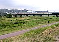
Bridge over the Tama near Fuchū-Honmachi


history
Nambu Tetsudo
On May 5, 1919, a license application for the construction of the "Tamagawa gravel track" was submitted. A steam-powered railway line was to be built along the lower reaches of the Tama in order to transport the gravel quarried on the river bank near Inagi to Kawasaki . The Ministry of Transport issued the license on January 29, 1920. Two months later, on March 29, 1920, the company was renamed Nambu Tetsudō ( 南 武 鉄 道 ). Shortly before, it had received approval to move the northern terminus to Tachikawa . Likewise, the route should now not only carry goods, but also passengers. In the initial phase, the company struggled with funding and local promoters dropped out, which delayed the start of construction several times. In order to reduce costs, the planned route was changed significantly, so that only the purchase of inexpensive rice fields was necessary.
Asano - Zaibatsu , which specializes in cement , was owned by the Ōme Denki Tetsudō railway company . So that the limestone quarried in the upper Tama Valley could get to the cement works in Kawasaki, it had to be transported from Tachikawa on the Chūō main line , the Yamanote line and the Tōkaidō main line . The planned direct rail line from Tachikawa to Kawasaki would make the time-consuming detour superfluous. On September 30, 1923, Asano acquired 5,000 shares for this reason and was now the largest shareholder. The opening of the first section from Kawasaki Station to Noborito (including the branch line from Yakō to the Kawasakigashi freight yard) took place on March 9, 1927.
With the exception of the branch line, the Nambu line was electrified from the start. The Nambu Tetsudō took further sections into operation: on November 1, 1927 from Noborito to Ōmaru (today Minami-Tama), on December 11, 1928 to Yashikibun (today Bubaigawara ) and on December 11, 1929 to Tachikawa . Finally, on March 25, 1930, the branch line from Shitte to Hama-Kawasaki was added, which established a connection to the port. Likewise, part of the Nambu line was expanded to two tracks: on September 29, 1928 between Yako and Mukaigawara and on March 20, 1929 between Kawasaki and Yako.
In the 1930s, NEC and Fujitsu built several production facilities along the route. This led to a strong growth in commuter traffic, which resulted in the construction of additional train stations. In order to be able to cope with the marked increase in traffic (also in freight traffic), the Nambu Tetsudō expanded further sections on two tracks: on October 30, 1937 from Mukaigawara to Musashi-Nakahara, on April 5, 1939 from Musashi-Nakahara to Musashi-Mizonokuchi , From Tsudayama to Kuji in 1941 and from Shukugawara to Noborito on December 20, 1943. During the Pacific War , private and state arms companies settled along the route. The Imperial Japanese Army expanded its defensive positions along the route to protect the numerous military transports.
Nationalization and reprivatisation
In order to streamline operations, the Asano-Zaibatsu united its railway companies under the umbrella of Nambu Tetsudō. First, October 3, 1940, the Itsukaichi Tetsudō went into it, on September 8, 1943 also the Ōme Denki Tetsudō. During the war, the Japanese state strove to bring under its control various private railways of strategically important importance, which had emerged after the first wave of nationalization in 1906/07 . According to an ordinance issued in 1941, a total of 22 railway companies were affected by the nationalization, including the Nambu Tetsudō, whose railway lines passed into state ownership on April 1, 1944 ( Tsurumi Rinkō Tetsudō, also belonging to the Asano-Zaibatsu, in the port area of Kawasaki on July 1 1943). The Nambu Tetsudō remained as a company and shifted its business activities to the operation of bus routes. Today it operates as Tachikawa Bus and belongs to the Odakyu Group .
In 1945, the route suffered major damage several times from air raids by the United States Army Air Forces . Two months after the end of the war, only 19 of 41 of the railcars used here were available. Because of the narrow clearance profile of the double-track sections at the time, no wagons from other state railway lines could run here, as they were all wider. The Ministry of Transport therefore temporarily rented narrower wagons from Odakyū Dentetsu in 1947 . Given these circumstances, calls were made to re-privatize the Nambu Line for practical reasons. Ultimately, however, the route remained in state ownership.

In 1951, the Japanese State Railways opened a branch line from Shitte to Tsurumi reserved for freight traffic . It responded to increasing suburbanization and the associated capacity bottlenecks with a further expansion of the Nambu line. Gradually, further double-track sections were added: on March 20, 1960 between Kuji and Shukugawara, seven days later between Musashi-Mizonokuchi and Tsudayama, on November 7, 1963 between Noborito and Inadazutsumi, and on November 12, 1963 between Inadazutsumi and Inagi-Naganuma and on May 25, 1966 between Yaho and Nishi-Kunitachi. With the section between Inagi-Naganuma and Yaho, the double-track expansion of the main line of the Nambu Line was initially completed on September 30, 1966, a short section remained between Nishi-Kunitachi and Tachikawa.
From December 15, 1969, the state railroad offered express trains between Kawasaki and Noborito , but canceled this offer with the timetable change on October 2, 1976, as new railcars made a higher travel speed possible. On May 25, 1972, the branch line from Yakō to the Kawasakigashi freight yard was closed. As a result of the opening of the Musashino line on March 1, 1976, the volume of freight traffic between Shitte and Tachikawa fell significantly. On the other hand, a significant increase south of Shitte had been forecast, which is why the section between Hatchōnawate and Hama-Kawasaki could be used on two tracks from the same day.
As part of the privatization of the state railway, the Nambu line went into the possession of the new company JR East on April 1, 1987 , while JR Freight was now responsible for freight traffic on the main and both branch lines. With a delay of more than three decades, the last single-track section between Nishi-Kunitachi and Tachikawa was closed on October 24, 1999, for which an additional platform had to be built in Tachikawa station. In March 2006, JR East introduced the automated train operating system ATOS (Autonomous Decentralized Transport Operation Control System) on the main line of the Nambu Line. On April 9th, express trains were reintroduced.
List of train stations


| Surname | km | Connecting lines | location | place | prefecture | |
|---|---|---|---|---|---|---|
| Main line | ||||||
| JN01 | Kawasaki ( 川 崎 ) | 0.0 |
Tōkaidō Main Line Keihin Tōhoku Line at Keikyū Kawasaki Station : Keikyū Main Line Keikyū Daishi Line |
Coord. | Kawasaki-ku , Kawasaki | Kanagawa |
| JN02 | Shitte ( 尻 手 ) | 1.7 | Nambu branch line | Coord. | Saiwai-ku , Kawasaki | |
| JN03 | Yakō ( 矢 向 ) | 2.6 | Coord. | Tsurumi-ku , Yokohama | ||
| JN04 | Kashimada ( 鹿島 田 ) | 4.1 |
at Shin-Kawasaki station : Yokosuka line Shōnan-Shinjuku line |
Coord. | Saiwai-ku, Kawasaki | |
| JN05 | Hirama ( 矢 向 ) | 5.3 | Coord. | Nakahara-ku , Kawasaki | ||
| JN06 | Mukaigawara ( 矢 向 ) | 6.6 | Coord. | |||
| JN07 | Musashi-Kosugi ( 武 蔵 小 杉 ) | 7.5 |
Yokosuka Line Shōnan Shinjuku Line Tōkyū Tōyoko Line Tōkyū Meguro Line |
Coord. | ||
| JN08 | Musashi-Nakahara ( 武 蔵 中原 ) | 9.2 | Coord. | |||
| JN09 | Musashi-Shinjō ( 武 蔵 新城 ) | 10.5 | Coord. | |||
| JN10 |
Musashi-Mizonokuchi ( 武 蔵 溝 ノ 口 ) |
12.7 |
at Mizonokuchi station : Tōkyū Den'entoshi line, Tōkyū Ōimachi line |
Coord. | Takatsu-ku , Kawasaki | |
| JN11 | Tsudayama ( 津 田 山 ) | 13.9 | Coord. | |||
| JN12 | Kuji ( 久 地 ) | 14.9 | Coord. | |||
| JN13 | Shukugawara ( 宿 河 原 ) | 16.2 | Coord. | Tama-ku , Kawasaki | ||
| JN14 | Noborito ( 登 戸 ) | 17.3 | Odakyū Odawara line | Coord. | ||
| JN15 | Nakanoshima ( 中 野 島 ) | 19.5 | Coord. | |||
| JN16 | Inadazutsumi ( 稲 田 堤 ) | 20.8 |
at Keiō-Inadazutsumi station: Keiō Sagamihara line |
Coord. | ||
| JN17 | Yanokuchi ( 矢野 口 ) | 22.4 | Coord. | Inagi | Tokyo | |
| JN18 | Inagi-Naganuma ( 稲 城 長 沼 ) | 24.1 | Coord. | |||
| JN19 | Minami-Tama ( 南多摩 ) | 25.5 | Coord. | |||
| JN20 | Fuchū-Honmachi ( 府中本 町 ) | 27.9 | Musashino line | Coord. | Foxu | |
| JN21 | Bubaigawara ( 分 倍 河 原 ) | 28.8 | Keiō line | Coord. | ||
| JN22 | Nishifu ( 西 府 ) | 30.0 | Coord. | |||
| JN23 | Yaho ( 谷 保 ) | 31.6 | Coord. | Kunitachi | ||
| JN24 | Yagawa ( 矢 川 ) | 33.0 | Coord. | |||
| JN25 | Nishi-Kunitachi ( 西 国立 ) | 34.3 | Coord. | Tachikawa | ||
| JN26 | Tachikawa ( 立 川 ) | 35.5 |
Chūō Main Line ( Chūō Rapid Train Line ) Ōme Line to Tachikawa-Kita and Tachikawa-Minami stations: Tama monorail |
Coord. | ||
| Hamakawasaki branch line | ||||||
| JN02 | Shitte ( 尻 手 ) | 0.0 | Main line | Saiwai-ku , Kawasaki | Kanagawa | |
| JN51 | Hatchōnawate ( 八 丁 畷 ) | 1.1 | Keikyū main line | Coord. | Kawasaki-ku , Kawasaki | |
| JN52 | Kawasaki Shinmachi ( 川 崎 新 町 ) | 2.0 | Coord. | |||
| JN53 | Odasakae ( 小田 栄 ) | 2.7 | Coord. | |||
| JN54 | Hama-Kawasaki ( 浜 川 崎 ) | 4.1 | Tsurumi line | Coord. | ||
| Tsurumi branch line (freight only) | ||||||
| Shitte ( 尻 手 ) | 0.0 | Main line | Saiwai-ku, Kawasaki | Kanagawa | ||
| Tsurumi ( 鶴 見 ) | 5.4 | Keihin-Tōhoku Line | Coord. | Tsurumi-ku , Kawasaki | ||
Web links
- JR East route network (PDF, 1.2 MB)
Individual evidence
- ↑ Masayuki Saka: 東京 メ ガ ル ー プ 車 両 ・ 路線 の 沿革 と 現 況 . In: Tetsudō Daiya Jōhō Magazine . tape 43 , no. 364 . Kōtsū shinbunsha, Tokyo August 2014, p. 28-39 .
- ↑ JR 時刻表 2019 年 3 月 号 (JR timetable March 2019). Kōtsū shinbunsha, Tokyo 2019.
- ↑ Atsushi Suzuki: 高 津 物語 上 巻 . Town News, Yokohama 2004, pp. 186 .
- ↑ 鉄 道 免 許 状 下 付. In: Official Gazette. National Parliamentary Library , January 30, 1920; accessed March 3, 2020 (Japanese).
- ↑ 地方 鉄 道 及 軌道 一 覧: 附 ・ 専 用 鉄 道. In: Official Gazette. National Parliamentary Library, April 10, 1920, accessed March 3, 2020 (Japanese).
- ↑ Suzuki: 高 津 物語 上 巻. P. 187.
- ↑ Suzuki: 高 津 物語 上 巻. P. 189.
- ↑ 地方 鉄 道 運輸 開始. In: Official Gazette. National Parliamentary Library, March 17, 1927, accessed March 3, 2020 (Japanese).
- ↑ Satoru Sone (Ed.): 週刊 歴 史 で め ぐ る 鉄 道 全 路線 国 鉄 ・ JR . tape 38 . Asahi Shimbun shuppan, Tokyo 2010, p. 20 .
- ↑ a b c Sone: 週刊 歴 史 で め ぐ る 鉄 道 全 路線 国 鉄 ・ JR. P. 21.
- ↑ Suzuki: 高 津 物語 上 巻. P. 194.
- ↑ 運輸 通信 省 告示 第 117 号. In: Official Gazette. National Library of Parliament, March 29, 1944, accessed March 3, 2020 (Japanese).
- ↑ Katsumasa Harada (Ed.): 南 武 線 い ま む か し . Tamagawa Shimbunsha, Kawasaki 1999, ISBN 978-4-924882-28-7 , pp. 97-103 .
- ↑ 南 武 線 に 33 年 ぶ り の 「快速」. Town News, October 1, 2010; archived from the original on October 17, 2010 ; Retrieved March 5, 2020 (Japanese).
- ↑ 南 武 線 で 快速 列車 の 運 転 が 始 ま る. Tetsudō Fan, April 10, 2011, accessed March 5, 2020 (Japanese).
Shinkansen: Akita Shinkansen | Gala Yuzawa Line | Hokuriku Shinkansen | Jōetsu Shinkansen | Tōhoku Shinkansen | Yamagata Shinkansen
Lines in Greater Tokyo: Akabane Line | Chūō Main Line ( Chūō Rapid Railway Line , Chūō-Sōbu Line ) | Hachikō line | Itsukaichi line | Jōban line | Jōetsu line | Kashima line | Kawagoe line | Keihin Tōhoku Line | Keiyō line | Kururi line | Narita line | Mito line | Musashino line | Nambu line | Negishi line | Ōme line | Ryōmō Line | Sagami line | Saikyō Line | Shōnan Shinjuku Line | Sōbu Main Line ( Sōbu Rapid Train Line ) | Sotobō Line | Takasaki Line | Tōgane Line | Tōhoku Main Line ( Utsunomiya Line ) | Tōkaidō main line ( Tokyo – Atami ) | Tsurumi line | Uchibō Line | Ueno Tokyo Line | Yamanote Line | Yokohama Line | Yokosuka line
Lines in other regions: Agatsuma Line | Aterazawa Line | Ban'etsu East Line | Ban'etsu West Line | Echigo line | Gonō line | Hachinohe Line | Hakushin Line | Hanawa line | Iiyama line | Ishinomaki Line | Itō line | Kamaishi line | Karasuyama Line | Kesennuma Line | Kitakami line | Koumi line | Nikko Line | Ōito line | Ōfunato line | Oga line | Ōminato line | Ōu main line | Rifu line | Rikuu East Line | Rikuu West Line | Senseki line | Senseki-Tōhoku Line | Senzan Line | Shin'etsu main line | Shinonoi line | Suigun line | Tadami line | Tazawako Line | Tsugaru Line | Uetsu main line | Yahiko line | Yamada line | Yonesaka line