Yokohama line
| Yokohama line | |||||||||||||||||||||||||||||||||||||||||||||||||||||||||||||||||||||||||||||||||||||||||||||||||||||||||||||||||||||||||||||||||||||||||||||||||||||||||||||||||||||||||||||||||||||||||||||||||||||||||||||||||||||||||||||||||||||||||||||||||
|---|---|---|---|---|---|---|---|---|---|---|---|---|---|---|---|---|---|---|---|---|---|---|---|---|---|---|---|---|---|---|---|---|---|---|---|---|---|---|---|---|---|---|---|---|---|---|---|---|---|---|---|---|---|---|---|---|---|---|---|---|---|---|---|---|---|---|---|---|---|---|---|---|---|---|---|---|---|---|---|---|---|---|---|---|---|---|---|---|---|---|---|---|---|---|---|---|---|---|---|---|---|---|---|---|---|---|---|---|---|---|---|---|---|---|---|---|---|---|---|---|---|---|---|---|---|---|---|---|---|---|---|---|---|---|---|---|---|---|---|---|---|---|---|---|---|---|---|---|---|---|---|---|---|---|---|---|---|---|---|---|---|---|---|---|---|---|---|---|---|---|---|---|---|---|---|---|---|---|---|---|---|---|---|---|---|---|---|---|---|---|---|---|---|---|---|---|---|---|---|---|---|---|---|---|---|---|---|---|---|---|---|---|---|---|---|---|---|---|---|---|---|---|---|---|---|---|---|---|---|---|---|---|---|---|---|---|---|---|---|---|---|
|
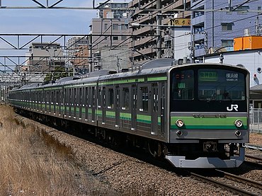
Class 205 multiple unit at Fuchinobe
| |||||||||||||||||||||||||||||||||||||||||||||||||||||||||||||||||||||||||||||||||||||||||||||||||||||||||||||||||||||||||||||||||||||||||||||||||||||||||||||||||||||||||||||||||||||||||||||||||||||||||||||||||||||||||||||||||||||||||||||||||
| Route length: | 42.6 km | ||||||||||||||||||||||||||||||||||||||||||||||||||||||||||||||||||||||||||||||||||||||||||||||||||||||||||||||||||||||||||||||||||||||||||||||||||||||||||||||||||||||||||||||||||||||||||||||||||||||||||||||||||||||||||||||||||||||||||||||||
| Gauge : | 1067 mm ( cape track ) | ||||||||||||||||||||||||||||||||||||||||||||||||||||||||||||||||||||||||||||||||||||||||||||||||||||||||||||||||||||||||||||||||||||||||||||||||||||||||||||||||||||||||||||||||||||||||||||||||||||||||||||||||||||||||||||||||||||||||||||||||
| Power system : | 1500 V ~ | ||||||||||||||||||||||||||||||||||||||||||||||||||||||||||||||||||||||||||||||||||||||||||||||||||||||||||||||||||||||||||||||||||||||||||||||||||||||||||||||||||||||||||||||||||||||||||||||||||||||||||||||||||||||||||||||||||||||||||||||||
| Top speed: | 95 km / h | ||||||||||||||||||||||||||||||||||||||||||||||||||||||||||||||||||||||||||||||||||||||||||||||||||||||||||||||||||||||||||||||||||||||||||||||||||||||||||||||||||||||||||||||||||||||||||||||||||||||||||||||||||||||||||||||||||||||||||||||||
| Dual track : | whole route | ||||||||||||||||||||||||||||||||||||||||||||||||||||||||||||||||||||||||||||||||||||||||||||||||||||||||||||||||||||||||||||||||||||||||||||||||||||||||||||||||||||||||||||||||||||||||||||||||||||||||||||||||||||||||||||||||||||||||||||||||
| Society: | JR East | ||||||||||||||||||||||||||||||||||||||||||||||||||||||||||||||||||||||||||||||||||||||||||||||||||||||||||||||||||||||||||||||||||||||||||||||||||||||||||||||||||||||||||||||||||||||||||||||||||||||||||||||||||||||||||||||||||||||||||||||||
|
|||||||||||||||||||||||||||||||||||||||||||||||||||||||||||||||||||||||||||||||||||||||||||||||||||||||||||||||||||||||||||||||||||||||||||||||||||||||||||||||||||||||||||||||||||||||||||||||||||||||||||||||||||||||||||||||||||||||||||||||||
The Yokohama Line ( Japanese 横 浜 線 , Yokohama-sen ) is a railway line on the Japanese island of Honshū , which is operated by the JR East railway company . It connects Yokohama in Kanagawa Prefecture with Hachiōji in Tokyo Prefecture . It creates a cross-connection between the Tōkaidō main line and the Chūō main line in the west of the Tokyo metropolitan area. On the one hand it enables an important tangential connection , on the other hand it opens up the northwestern suburbs of Yokohama and the southwestern suburbs of Tokyo (including Machida and Sagamihara ).
description
As is usual in Japan, the Yokohama line is laid in Cape Gauge (1067 mm). It is 42.6 km long, has two tracks and is electrified with 1500 V DC . A total of 20 stations are served. Together with the Keiyō Line , the Musashino Line and the Nambu Line , it is part of a large ring route called the Tokyo Mega Loop ( 東京 メ ガ ル ー プ ) around central Tokyo.
The nominal southern starting point of the Yokohama Line is Higashi-Kanagawa Station , which is just under two kilometers northeast of Yokohama Central Station . The route follows the Keihin-Tōhoku line for around one and a half kilometers before turning north. It crosses under the Tōkaidō freight line and takes a westerly direction shortly before the Terao tunnel. In Kikuna station it crosses the Tōyoko line , in Shin-Yokohama station it runs under the Tōkaidō-Shinkansen high-speed line . Passing the Nissan Stadium , the route reaches the Tsurumi Valley and gradually turns northwest at Nakayama . The Yokohama Line crosses the Den'entoshi Line at Nagatsuta Station and also connects to the Kodomonokuni Line . Another important hub is Machida Station , where the Odakyū Odawara Line passes under . Following the Sakai Valley , the route reaches Hashimoto Station and then turns north. Two parallel, single-lane tunnels several hundred meters in length cross a range of hills in the Tama Hills . After crossing the Keiō Takao Line , the Yokohama Line ends at Hachiōji Station .
Trains
There is a close connection of the Yokohama Line with short sections of the Keihin-Tōhoku Line and the Negishi Line . On weekdays between 9 a.m. and 3 p.m. and on weekends between 9 a.m. and 5 p.m., three express trains are offered every hour , each of which skips several stations. They run first from Hachiōji to Higashi-Kanagawa and then via Yokohama to Sakuragichō . As far as local transport is concerned, there is an operational dichotomy; on the one hand the trains run between Hachiōji and Higashi-Kanagawa, on the other hand between Hashimoto and Sakuragichō (three times an hour each), which results in six connections per hour in the middle section. During the rest of the day, there are no express trains and are replaced by local trains (five per hour in the evening, up to 15 during rush hour ), with the majority being tied through to Sakuragichō. During rush hour, individual additional trains are offered from Hachiōji, which switch to the Sagami line in Hashimoto and run to Chigasaki .
history
The private railway company Yokohama Tetsudō ( 横 浜 鉄 道 ) opened on September 23, 1908, the entire route from Higashi-Kanagawa to Hachiōji . It was originally built mainly for the purpose of transporting raw silk from the region around Hachiōji and Kōfu to the textile factories in Yokohama . On April 1, 1910, the railway company signed a leasing contract with the state . The Railway Office of the Cabinet (later the Ministry of Railways ) now ran the railway, as did the freight connecting line from Higashi-Kanagawa to Umi-Kanagawa, which opened on December 10, 1911 . Finally, on October 1, 1917, the Yokohama Tetsudō went completely into state ownership.
Because of its proximity to the headquarters and the relatively low volume of traffic, the state railway used the Yokohama Line as a test route. For example, from May to August 1917, she examined the possibility of converting the entire route network to standard gauge . In April 1925 she carried out a trial electrification of the section between Higashi-Kanagawa and Machida in order to gain experience for the planned conversion of the Tōkaidō main line . The electrification for regular operation took place in two phases. First, on October 1, 1932, electrical operations between Higashi-Kanagawa and Machida began, whereupon continuous trains to and from Sakuragichō could be offered. From October 1, 1933, diesel multiple units were used on the rest of the route until the rest of the route was electrified on April 5, 1941.
During an area bombing by the United States Army Air Forces on Yokohama on May 29, 1945, Higashi-Kanagawa station burned down completely. Although a temporary solution was immediately set up, the direct connection between the Yokohama Line and Sakuragichō remained interrupted until April 13, 1959. Due to a reorganization of the traffic flows in the port of Yokohama, the Japanese State Railways closed the branch line to Umi-Kanagawa on April 1, 1959. The commissioning of the Shin-Yokohama station on the new Tōkaidō-Shinkansen high-speed line on October 1, 1964 and the opening of new universities resulted in a marked increase in the number of passengers. For this reason, the Yokohama line had to be expanded to two tracks in stages: on October 22, 1967 between Kikuna and Shin-Yokohama, on February 4, 1968 between Shin-Yokohama and Kozukue, on March 12, 1968 between Ōguchi and Kikuna, and on March 19 , 1968 between Shin-Yokohama and Kozukue . March 1968 between Higashi-Kanagawa and Ōguchi.
After a ten-year break, the state railway continued the double-track expansion: on October 2, 1978 between Kozukue and Nakayama , on April 1, 1979 between Nakayama and Nagatsuta , on July 15, 1979 between Nagatsuta and Machida, on September 14, 1979 between Fuchinobe and Aihara and on September 27, 1980 between Machida and Fuchinobe. As part of the privatization of the state railway, the Yokohama line went into the possession of the new company JR East on April 1, 1987 . This expanded the last remaining single-track section between Aihara and Hachiōji, making the line consistently double-tracked from March 6, 1988. The continuing increase in passenger numbers led to the introduction of express trains on March 13 of the same year . Further selective improvements were made in the following years, for example the repeal of level crossings at various locations.
List of train stations
| Surname | km | Connecting lines | location | place | prefecture | |
|---|---|---|---|---|---|---|
| JH13 | Higashi-Kanagawa ( 東 神奈川 ) | 0.0 |
Keihin Tōhoku Line at Nakakido Station: Keikyū Main Line |
Coord. | Kanagawa-ku , Yokohama | Kanagawa |
| JH14 | Ōguchi ( 大 口 ) | 2.2 | Coord. | |||
| JH15 | Kikuna ( 菊 名 ) | 4.8 | Tōkyū Tōyoko Line | Coord. | Kōhoku-ku , Yokohama | |
| JH16 | Shin-Yokohama ( 新 横 浜 ) | 6.1 |
Tōkaidō Shinkansen Subway Yokohama : Blue Line |
Coord. | ||
| JH17 | Kozukue ( 小 机 ) | 7.8 | Coord. | |||
| JH18 | Kamoi ( 鴨 居 ) | 10.9 | Coord. | Midori-ku , Yokohama | ||
| JH19 | Nakayama ( 中山 ) | 13.5 |
Yokohama Subway: Green Line |
Coord. | ||
| JH20 | Tōkaichiba ( 十 日 市場 ) | 15.9 | Coord. | |||
| JH21 | Nagatsuta ( 長 津 田 ) | 17.9 |
Tōkyū Den'entoshi Line Kodomonokuni Line |
Coord. | ||
| JH22 | Naruse ( 成 瀬 ) | 20.2 | Coord. | Machida | Tokyo | |
| JH23 | Machida ( 町 田 ) | 22.9 | Odakyū Odawara line | Coord. | ||
| JH24 | Kobuchi ( 古 淵 ) | 25.7 | Coord. | Sagamihara | Kanagawa | |
| JH25 | Fuchinobe ( 淵 野 辺 ) | 28.4 | Coord. | |||
| JH26 | Yabe ( 矢 部 ) | 29.2 | Coord. | |||
| JH27 | Sagamihara ( 相 模 原 ) | 31.0 | Coord. | |||
| JH28 | Hashimoto ( 橋本 ) | 33.8 |
Sagami Line Keiō Sagamihara Line |
Coord. | ||
| JH29 | Aihara ( 相 原 ) | 35.7 | Coord. | Machida | Tokyo | |
| JH30 | Hachiōji-Minamino ( 八 王子 み な み 野 ) |
38.6 | Coord. | Hachiōji | ||
| JH31 | Katakura ( 片 倉 ) | 40.0 | Coord. | |||
| JH32 | Hachiōji ( 八 王子 ) | 42.6 |
Chūō Main Line ( Chūō Rapid Train Line ) Hachikō Line at Keiō-Hachiōji Station : Keiō Line |
Coord. | ||
Web links
- JR East route network (PDF, 1.2 MB)
Individual evidence
- ↑ Masayuki Saka: 東京 メ ガ ル ー プ 車 両 ・ 路線 の 沿革 と 現 況 . In: Tetsudō Daiya Jōhō Magazine . tape 43 , no. 364 . Kōtsū shinbunsha, Tokyo August 2014, p. 28-39 .
- ↑ Weekday timetable from Hashimoto towards Higashi-Kanagawa. JR East , 2020, accessed April 14, 2020 (Japanese).
- ↑ JR 時刻表 2019 年 3 月 号 (JR timetable March 2019). Kōtsū shinbunsha, Tokyo 2019.
- ↑ Shunzō Miyawaki, Katsumasa Harada: 全線 全 駅 鉄 道 の 旅 4 関 東 JR 私 鉄 2100 キ ロ . Shogakukan, Chiyoda 1991, ISBN 978-4-09-395304-7 , pp. 80 .
- ↑ Hirokazu Hasegawa: 横 浜 の 鉄 道 物語 . JTB Publishing, Tokyo 2004, ISBN 4-533-05622-9 , pp. 70 .
- ↑ a b c Satoshi Kubo: 神奈川 往還 ・ 絹 の 道 横 浜 線 . In: Tetsudō Fan . No. 658 . Koyusha, Naha February 2016, pp. 115 .
- ↑ Hasegawa: 横 浜 の 鉄 道 物語. Pp. 72-73.
- ↑ 大都市 圏 JR 線 区 の 快速 運 転 - JR 各 社 の 快速 運 転 状況 JR 東 日本 東京 圏 . In: Tetsudō Pikutoriaru . No. 736 . Denkisha kenkyūkai, Chiyoda September 2003, p. 47 .


