
Keiō line
| Keiō line | |||||||||||||||||||||||||||||||||||||||||||||||||||||||||||||||||||||||||||||||||||||||||||||||||||||||||||||||||||||||||||||||||||||||||||||||||||||||||||||||||||||||||||||||||||||||||||||||||||||||||||||||||||||||||||||||||||||||||||||||||||||||||||||||||||||||||||||||||||||||||||||||||||||||||||||||||||||||||||||||||||||||||||||||||||||||||||||||||||||||||||||||||||||||||||||
|---|---|---|---|---|---|---|---|---|---|---|---|---|---|---|---|---|---|---|---|---|---|---|---|---|---|---|---|---|---|---|---|---|---|---|---|---|---|---|---|---|---|---|---|---|---|---|---|---|---|---|---|---|---|---|---|---|---|---|---|---|---|---|---|---|---|---|---|---|---|---|---|---|---|---|---|---|---|---|---|---|---|---|---|---|---|---|---|---|---|---|---|---|---|---|---|---|---|---|---|---|---|---|---|---|---|---|---|---|---|---|---|---|---|---|---|---|---|---|---|---|---|---|---|---|---|---|---|---|---|---|---|---|---|---|---|---|---|---|---|---|---|---|---|---|---|---|---|---|---|---|---|---|---|---|---|---|---|---|---|---|---|---|---|---|---|---|---|---|---|---|---|---|---|---|---|---|---|---|---|---|---|---|---|---|---|---|---|---|---|---|---|---|---|---|---|---|---|---|---|---|---|---|---|---|---|---|---|---|---|---|---|---|---|---|---|---|---|---|---|---|---|---|---|---|---|---|---|---|---|---|---|---|---|---|---|---|---|---|---|---|---|---|---|---|---|---|---|---|---|---|---|---|---|---|---|---|---|---|---|---|---|---|---|---|---|---|---|---|---|---|---|---|---|---|---|---|---|---|---|---|---|---|---|---|---|---|---|---|---|---|---|---|---|---|---|---|---|---|---|---|---|---|---|---|---|---|---|---|---|---|---|---|---|---|---|---|---|---|---|---|---|---|---|---|---|---|---|---|---|---|---|---|---|---|---|---|---|---|---|---|---|---|---|---|---|---|---|---|---|---|---|---|---|---|---|---|---|---|---|---|---|---|---|---|---|---|---|---|---|---|---|---|---|---|---|---|---|---|---|---|---|
| Route length: | 37.9 km | ||||||||||||||||||||||||||||||||||||||||||||||||||||||||||||||||||||||||||||||||||||||||||||||||||||||||||||||||||||||||||||||||||||||||||||||||||||||||||||||||||||||||||||||||||||||||||||||||||||||||||||||||||||||||||||||||||||||||||||||||||||||||||||||||||||||||||||||||||||||||||||||||||||||||||||||||||||||||||||||||||||||||||||||||||||||||||||||||||||||||||||||||||||||||||||
| Gauge : | 1372 mm ( Scottish gauge ) | ||||||||||||||||||||||||||||||||||||||||||||||||||||||||||||||||||||||||||||||||||||||||||||||||||||||||||||||||||||||||||||||||||||||||||||||||||||||||||||||||||||||||||||||||||||||||||||||||||||||||||||||||||||||||||||||||||||||||||||||||||||||||||||||||||||||||||||||||||||||||||||||||||||||||||||||||||||||||||||||||||||||||||||||||||||||||||||||||||||||||||||||||||||||||||||
| Power system : | 1500 V = | ||||||||||||||||||||||||||||||||||||||||||||||||||||||||||||||||||||||||||||||||||||||||||||||||||||||||||||||||||||||||||||||||||||||||||||||||||||||||||||||||||||||||||||||||||||||||||||||||||||||||||||||||||||||||||||||||||||||||||||||||||||||||||||||||||||||||||||||||||||||||||||||||||||||||||||||||||||||||||||||||||||||||||||||||||||||||||||||||||||||||||||||||||||||||||||
| Minimum radius : | 110 m | ||||||||||||||||||||||||||||||||||||||||||||||||||||||||||||||||||||||||||||||||||||||||||||||||||||||||||||||||||||||||||||||||||||||||||||||||||||||||||||||||||||||||||||||||||||||||||||||||||||||||||||||||||||||||||||||||||||||||||||||||||||||||||||||||||||||||||||||||||||||||||||||||||||||||||||||||||||||||||||||||||||||||||||||||||||||||||||||||||||||||||||||||||||||||||||
| Top speed: | 110 km / h | ||||||||||||||||||||||||||||||||||||||||||||||||||||||||||||||||||||||||||||||||||||||||||||||||||||||||||||||||||||||||||||||||||||||||||||||||||||||||||||||||||||||||||||||||||||||||||||||||||||||||||||||||||||||||||||||||||||||||||||||||||||||||||||||||||||||||||||||||||||||||||||||||||||||||||||||||||||||||||||||||||||||||||||||||||||||||||||||||||||||||||||||||||||||||||||
| Dual track : | whole route | ||||||||||||||||||||||||||||||||||||||||||||||||||||||||||||||||||||||||||||||||||||||||||||||||||||||||||||||||||||||||||||||||||||||||||||||||||||||||||||||||||||||||||||||||||||||||||||||||||||||||||||||||||||||||||||||||||||||||||||||||||||||||||||||||||||||||||||||||||||||||||||||||||||||||||||||||||||||||||||||||||||||||||||||||||||||||||||||||||||||||||||||||||||||||||||
| Society: | Keiō Dentetsu | ||||||||||||||||||||||||||||||||||||||||||||||||||||||||||||||||||||||||||||||||||||||||||||||||||||||||||||||||||||||||||||||||||||||||||||||||||||||||||||||||||||||||||||||||||||||||||||||||||||||||||||||||||||||||||||||||||||||||||||||||||||||||||||||||||||||||||||||||||||||||||||||||||||||||||||||||||||||||||||||||||||||||||||||||||||||||||||||||||||||||||||||||||||||||||||
|
|||||||||||||||||||||||||||||||||||||||||||||||||||||||||||||||||||||||||||||||||||||||||||||||||||||||||||||||||||||||||||||||||||||||||||||||||||||||||||||||||||||||||||||||||||||||||||||||||||||||||||||||||||||||||||||||||||||||||||||||||||||||||||||||||||||||||||||||||||||||||||||||||||||||||||||||||||||||||||||||||||||||||||||||||||||||||||||||||||||||||||||||||||||||||||||
The Keiō Line ( Japanese 京 王 線 , Keiō-sen ) is a railway line on the Japanese island of Honshū , which is operated by the Keiō Dentetsu railway company . In Tokyo Prefecture , it connects the downtown Shinjuku train station with the cities of Chōfu , Fuchū and Hachiōji in the Tama region . It is the main route of the Keiō Dentetsu and connected with several short branches.
Route description
The 37.9 km long, double-track line is electrified with 1500 V DC . It serves 34 train stations and has a top speed of 110 km / h. An unusual feature of the Keiō line and the five lines branching off from it is the so-called "Scottish gauge" of 1372 mm (or 4½ feet ), which is otherwise only used in Japan on trams and a single subway line. This can be traced back to the origin of the Keiō line as an overland tram .
The eastern starting point is the three-track, north-south-facing Shinjuku tunnel station , which is parallel to the Odakyū Dentetsu and JR East facilities . In a sharp right-hand bend, the tunnel turns in a south-westerly direction and passes the disused train stations Hatsudai and Hatagaya. Immediately at the tunnel portal just before Sasazuka , the line joins the New Keiō Line . Above ground, it is now heading approximately westwards, and is on a viaduct until shortly before Daitabashi . It is then at ground level and has a large number of level crossings at the same level . In Meidaimae it crosses the Keiō Inokashira line at right angles , to which there is no track connection due to a different gauge.
The stations Kokuryō, Fuda and Chōfu were moved in 2012 in a tunnel that replaced an above-ground section with several level crossings. While the first two tunnel stations are double-track, Chōfu has four tracks on two levels because the heavily frequented Keiō Sagamihara line branches off here. In Higashi Fuchū the short branches Keio Keibajō line to Racecourse Tokyo from. At the Bubaigawara Tower Station , the JR East Nambu Line crosses on the upper level. The route then turns south for a short distance and crosses the Tama River . Following the south bank of the Asakawa tributary, you reach Takahatafudō , the starting point of the Keiō Dōbutsuen line to the Tama Zoo . The Keiō Takao line branches off at Kitano . The terminus is the double-track tunnel station Keiō-Hachiōji in the city center of Hachiōji .
Trains

The supply of trains on the Keiō line is very dense. For example, more than 20 trains run every hour from Shinjuku in central Tokyo during the day , even more during rush hour . They drive on the one hand the Keiō line along its entire length to Keiō-Hachiōji , on the other hand they turn onto the Keiō Sagamihara line or the Keiō Takao line and go to Hashimoto or Takaosanguchi . In addition to normal local trains, there are six types of express and express trains that stop at a different number of intermediate stations. Below is an overview:
■ Keio Liner ( 京 王 ラ イ ナ ー )
The Keio Liner introduced in February 2018 are geared towards the needs of long-distance passengers . They are the only trains for which a supplement is required, combined with a seat reservation. From Shinjuku they run every hour from 8:00 p.m. on weekdays, and from 4:20 p.m. on weekends and public holidays. From Keiō-Hachiōji back to Shinjuku they drive early in the morning. On the way they only stop in Fuchū , Bubaigawara , Takahatafudō and Kitano .
■ Tokkyū ( 特急 , Eng. Special Express )
The fastest trains without surcharge on the Keiō line cover the entire distance in 37 minutes. They stop at the same stations as the Keio Liner as well as in Meidaimae and Chofu .
■ Juntokkyū ( 準 特急 , English Semi Special Express )
These express trains run the most frequently. Compared to the Special Express , they also stop in Sasazuka and Chitose-Karasuyama. Individual trains are directed to Fuchūkeiba-seimommae at major events on the Tokyo racecourse .
■ Kyūkō ( 急 行 , English express )
These are express trains that are linked from the Toei Shinjuku line of the Tokyo subway to the New Keiō line and only meet the Keiō line in Sasazuka. From there they also stop in Sakurajōsui, Tsutsujigaoka and Higashi-Fuchū compared to the Semi Special Express . Individual trains are directed to Tama-Dōbutsukōen on weekends and holidays .
■ Kukan-kyūkō ( 区間 急 行 , English Semi Express )
Compared to the Semi Special Express , these trains between Shinjuku and Higashi-Fuchū also stop in Sengawa and then at all train stations.
■ Kaisoku ( 快速 , English Rapid )
These trains leave out only a few stations near the center, from Chofu they stop everywhere.
■ Kakueki-teisha ( 各 駅 停車 , English Local ) Local
traffic with stops at all train stations is routed between Sasazuka and Shinjuku in almost all cases to the New Keiō Line and in many cases connected to the Toei Shinjuku Line.
history
Starts as an interurban tram
The oldest part of the Keiō line is the section between Sasazuka and Chōfu , opened on April 15, 1913 by the predecessor company Keiō Denki Kidō ( 京 王 電 気 軌道 ), where denki kido means "electric tram". This name is no coincidence, because the route was not licensed under the Railway Act, but under the Tram Act (the former did not provide for any electric suburban trains at that time). Thus, the cape gauge (1067 mm) common for railways was not used , but the "Scottish gauge" of 1372 mm as with the Tokyo tram .
Step by step, the route advanced a few hundred meters further east towards the city center: on October 11, 1913 from Sasazuka to Hatashiro, on April 8, 1914 to Hatashiro-Shōgakkō-mae, on June 11, 1914 to Nishisandō, on April 19, 1914 to Hatashiro-Shogakkō-mae November 1914 to Shinmachi, on March 31, 1915 to Aoibashi, on May 1, 1915 to the forecourt of the Shinjuku train station (Shinjuku-ekimae) and on May 30, 1915 to the provisional terminus at Shinjuku Oiwake. To the east of Hatagaya, the route ran largely flush with the road along the main road Kōshū Kaidō (corresponds to today's national road 20 ). In the west, the route extended from Chōfu on September 1, 1916, initially to Tobitakyū and on October 31, 1916 to Fuchū .
Continuous expansion
From 1920 to 1923, the line was expanded to two tracks. Due to power outages after the Great Kanto earthquake , operations were interrupted from September 1st to 4th, 1923. In 1922, the subsidiary Gyokunan Tetsudō ( 玉 南 電 気 鉄 道 ) was founded, which tackled the construction of a 16.3 km long connecting line from Fuchū to Higashi-Hachiōji (now Keiō-Hachiōji ). In order to be able to claim the funding promised by the state, it was created in accordance with the newly introduced Local Railway Act in Kapspur. It went into operation on March 24, 1925. The funding did not materialize, however, because the Ministry of Railways viewed the route as a competitor to the Chūō main line , which ran in parallel at a short distance . On December 1, 1926, the Gyokunan Tetsudō therefore merged with its parent company, which applied for a new concession for the connecting line. The change in gauge to 1372 mm, which was then started , was completed on June 1, 1927, which made it possible to offer through trains from Shinjuku to Hachiōji after the timetable change in May 1928.

Meanwhile the eastern terminus had been replaced. The Keiō-Shinjuku station, which opened on October 28, 1927, was on the first floor of a newly built office and warehouse building. There was a connection to the city trams, but no rail connection. In the following years, the Keiō Denki Kidō expanded the route. These included larger and additional stations, double-track expansion and, in particular, in June 1936, the relocation of the Hatagaya – Shinmachi section to an independent railway body. For this purpose, an unused drainage channel of the Tamagawa aqueduct was rebuilt.
The Pacific War brought about significant changes. On the basis of the law on the coordination of land transport companies, the Keiō Denki Kidō had to join the Daitōkyū conglomerate on May 31, 1944 , to which the Odakyū , Keikyū and Tokyū railway companies already belonged. After an air strike the United States Army Air Forces , the substation had destroyed Tenjinbashi and the voltage decreased because of that, the trains were no longer able to cope with the ramp to the overpass on the south side of Shinjuku Station. For this reason, the Keiō-Shinjuku station had to be shut down on July 24, 1945 and the terminus had to be relocated to the west entrance. On August 15, 1945, Daitōkyū submitted the application to subordinate the Keiō line to the Local Railway Act; the change came into effect on October 1 of the same year. The conglomerate disbanded three years later and in its place took over on June 1, 1948 the newly created Keiō Teito Dentetsu (since 1998 Keiō Dentetsu) operating the Keiō line.
Modernization and route relocation

After the end of the war, the population in the Tama region grew rapidly, which increasingly led to the overloading of the Keiō line. In July 1953, the section between Shinjuku and the now repealed Shinmachi station was given an independent railroad. However, the lack of barriers at the level crossings led to numerous problems, and the railway line stood in the way of the planned widening of the main street Kōshū Kaidō. For these reasons, the easternmost section was replaced by an underground route and started operating on April 1, 1963 together with a tunnel station in Shinjuku. On August 4 of the same year the overhead line voltage was increased from 600 V to 1500 V and on June 7, 1964 the tunnel was extended to the west of Hatsudai.
When the Ministry of Transport presented the construction of the Keiō Sagamihara line branching off in Chōfu to the planned city of Tama New Town in 1968 , those responsible knew that the capacity of the Keiō line would be far from sufficient. This is how the New Keiō Line , which runs largely parallel on a lower level and which went into operation on October 31, 1978 , was created between Shinjuku and Sasazuka . The Hatsudai and Hatagaya stations on the Keio Line were closed and replaced by new buildings on the New Keio Line. From March 16, 1980, this relief line also served to connect subway trains on the Toei Shinjuku line . On April 2, 1989, the western terminus Keiō-Hachiōji also received a tunnel station. Finally, after a four-year construction period, the Kokuryō, Fuda and Chōfu stations were moved underground on August 19, 2012, which meant that 18 level crossings could be repealed.
Capacity constraints
The Keiō Line is notorious for the high number of level crossings, which in connection with the heavy train traffic often leads to traffic jams on the surrounding streets. According to a survey by the Building Department of the Prefectural Administration ( Tokyo Metropolitan Government ), all 25 crossings are closed for more than 40 minutes an hour, 20 even for more than 50 minutes, during rush hour on the 7.2 kilometer section between Sasazuka and Sengawa alone. The problem is to be solved in the longer term by building a viaduct or tunnel.
The congestion of the keiō line itself also causes problems. During rush hour, the trains often run at intervals of just one minute, which in the event of delays sometimes leads to a crowd . The railway company and the prefecture administration therefore proposed in 2016 that the particularly heavily used section between Sasazuka and Chōfu be expanded to include four tracks.
List of train stations
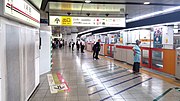
Keiō tunnel station in Shinjuku
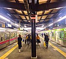
Sasazuka train station
Chofu station

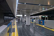
Keiō-Hachiōji Station


To = Tokkyū (Special Express); Ju = Juntokkyū (Semi Special Express); Ky = Kyūkō (express); Kk = Kukan-kyūkō (Semi Express); Ka = Kaisoku (Rapid); KL = Keio Liner
| Surname | km | To | Ju | Ky | Kk | Ka | KL | Connecting lines | location | place | |
|---|---|---|---|---|---|---|---|---|---|---|---|
| KO01 | Shinjuku ( 新宿 ) | 0.0 | ● | ● | ● | ● | ● | ● |
Chūō Main Line ( Chūō Rapid Train Line ) ( Chūō-Sōbu Line ) Saikyō Line Shōnan-Shinjuku Line Yamanote Line New Keiō Line Odakyū Odawara Line Tokyo Subway : Marunouchi Line Toei Shinjuku Line at Seibu Station -Shinjuku : Seibu Shinjuku Line in Subway Station. Shinjuku-Nishiguchi: Ōedo line |
Coord. | Shinjuku , Tokyo |
| KO04 | Sasazuka ( 笹 塚 ) | 3.6 | ● | ● | ● | ● | ǀ | ǀ | New Keiō line | Coord. | Shibuya , Tokyo |
| KO05 | Daitabashi ( 代 田 橋 ) | 4.4 | ǀ | ǀ | ǀ | ǀ | ǀ | ǀ | Coord. | Setagaya , Tokyo | |
| KO06 | Meidaimae ( 明 大 前 ) | 5.2 | ● | ● | ● | ● | ● | ǀ | Keiō Inokashira lineage | Coord. | |
| KO07 | Shimo-Takaido ( 下 高井 戸 ) | 6.1 | ● | ǀ | ǀ | ǀ | ǀ | ǀ | Setagaya line | Coord. | |
| KO08 | Sakurajōsui ( 桜 上水 ) | 7.0 | ● | ● | ● | ǀ | ǀ | ǀ | Coord. | ||
| KO9 | Kami-Kitazawa ( 上 北 沢 ) | 7.8 | ǀ | ǀ | ǀ | ǀ | ǀ | ǀ | Coord. | ||
| KO10 | Hachimanyama ( 八 幡 山 ) | 8.4 | ● | ǀ | ǀ | ǀ | ǀ | ǀ | Coord. | Suginami , Tokyo | |
| KO11 | Roka-kōen ( 芦花 公園 ) | 9.1 | ǀ | ǀ | ǀ | ǀ | ǀ | ǀ | Coord. | Setagaya, Tokyo | |
| KO12 | Chitose-Karasuyama ( 千 歳 烏山 ) | 9.9 | ● | ● | ● | ● | ǀ | ǀ | Coord. | ||
| KO13 | Sengawa ( 仙 川 ) | 11.5 | ● | ● | ǀ | ǀ | ǀ | ǀ | Coord. | Chofu | |
| KO14 | Tsutsujigaoka ( つ つ じ ヶ 丘 ) | 12.5 | ● | ● | ● | ǀ | ǀ | ǀ | Coord. | ||
| KO15 | Shibasaki ( 柴 崎 ) | 13.3 | ǀ | ǀ | ǀ | ǀ | ǀ | ǀ | Coord. | ||
| KO16 | Kokuryō ( 国 領 ) | 14.2 | ǀ | ǀ | ǀ | ǀ | ǀ | ǀ | Coord. | ||
| KO17 | Fuda ( 布 田 ) | 14.9 | ǀ | ǀ | ǀ | ǀ | ǀ | ǀ | Coord. | ||
| KO18 | Chōfu ( 調 布 ) | 15.5 | ● | ● | ● | ● | ● | ǀ | Keiō Sagamihara lineage | Coord. | |
| KO19 | Nishi-Chōfu ( 西 調 布 ) | 17.0 | ● | ǀ | ǀ | ǀ | ǀ | ǀ | Coord. | ||
| KO20 | Tobitakyū ( 飛 田 給 ) | 17.7 | ● | ǀ | ǀ | ǀ | ǀ | ǀ | Coord. | ||
| KO21 | Musashinodai ( 武 蔵 野台 ) | 18.8 | ● | ǀ | ǀ | ǀ | ǀ | ǀ | Coord. | Foxu | |
| KO22 | Tama-Reien ( 多 磨 霊 園 ) | 19.6 | ● | ǀ | ǀ | ǀ | ǀ | ǀ | Coord. | ||
| KO23 | Higashi-Fuchū ( 東 府中 ) | 20.4 | ● | ● | ● | ǀ | ǀ | ǀ | Keiō Keibajō line | Coord. | |
| KO24 | Foxu ( 府中 ) | 21.9 | ● | ● | ● | ● | ● | ● | Coord. | ||
| KO25 | Bubaigawara ( 分 倍 河 原 ) | 23.1 | ● | ● | ● | ● | ● | ● | Nambu line | Coord. | |
| KO26 | Nakagawara ( 中 河 原 ) | 24.7 | ● | ● | ǀ | ǀ | ǀ | ǀ | Coord. | ||
| KO27 | Seiseki-Sakuragaoka ( 聖蹟 桜 ヶ 丘 ) | 26.3 | ● | ● | ● | ● | ● | ● | Coord. | Tama | |
| KO28 | Moguseas ( 百草 園 ) | 28.0 | ● | ● | ǀ | ǀ | ǀ | ǀ | Coord. | Hino | |
| KO29 | Takahatafudō ( 高 幡 不 動 ) | 29.7 | ● | ● | ● | ● | ● | ● |
Keiō Dōbutsuen Line Monorail Tama |
Coord. | |
| KO30 | Minamidaira ( 南平 ) | 32.1 | ● | ● | ǀ | ǀ | ǀ | ǀ | Coord. | ||
| KO31 | Hirayamajōshi-kōen ( 平 山城 址 公園 ) | 33.4 | ● | ● | ǀ | ǀ | ǀ | ǀ | Coord. | ||
| KO32 | Naganuma ( 長 沼 ) | 34.9 | ● | ● | ǀ | ǀ | ǀ | ǀ | Coord. | Hachiōji | |
| KO33 | Kitano ( 北野 ) | 36.1 | ● | ● | ● | ● | ● | ● | Keiō Takao Line | Coord. | |
| KO34 | Keiō-Hachiōji ( 京 王八 王子 ) | 37.9 | ● | ● | ● | ● | ● | ● |
in Hachiōji station : Chūō main line ( Chūō rapid transit line ) Hachikō line Yokohama line |
Coord. | |
Web links
- Keiō Dentetsu route network (PDF, 798 kB)
Individual evidence
- ^ Keiō Railway Map. (PDF, 820 kB) Keiō Dentetsu, 2019, accessed on January 31, 2020 .
- ↑ 京 王 ラ イ ナ ー 2 月 22 日 発 進 座席 指定 一律 400 円. Sankei News, January 24, 2018, accessed January 31, 2020 (Japanese).
- ↑ 2 月 22 日 か ら 当 社 初 と な る 有 料 の 座席 指定 列車 「京 王 ラ イ ナ ー ー」 が 夜間 時間 帯 に 運行 開始! (PDF, 533 kB) Keiō Dentetsu , January 24, 2018, accessed January 31, 2020 (Japanese).
- ↑ a b 京 王 電 気 軌道 株式会社 三 十年 史. National Parliamentary Library digital collection , 1941, accessed January 31, 2020 (Japanese).
- ^ Tetsudō Kyoku . In: Ministry of Land, Infrastructure, Transport and Tourism (ed.): Tetsudō Yōran (Heisei 20 Nendo) . Denkisha Kenkyūkai, Tokyo 2008, ISBN 978-4-88548-112-3 .
- ↑ 京 王 電 気 軌道 株式会社 三 十年 史. (Part 2). National Parliamentary Library digital collection, 1941, accessed January 31, 2020 (Japanese).
- ↑ 京 王 電 気 軌道 株式会社 三 十年 史. (Part 3). National Parliamentary Library digital collection, 1941, accessed January 31, 2020 (Japanese).
- ↑ 京 王 電 気 軌道 株式会社 三 十年 史. (Part 5). National Parliamentary Library digital collection, 1941, accessed January 31, 2020 (Japanese).
- ↑ a b c d Keiō Dentetsu (Ed.): 京 王 ハ ン ド ブ ッ ク 2016 . (Keiō Handbook 2016). Tama 2016.
- ↑ 京 王 電 気 軌道 株式会社 三 十年 史. (Part 7). National Parliamentary Library digital collection, 1941, accessed January 31, 2020 (Japanese).
- ↑ 京 王 「開 か ず の 踏 切」 日本 最多 を 返 上 で き る か. toyokeizai.com, June 7, 2016, accessed January 31, 2020 (Japanese).
- ↑ 京 王 「開 か ず の 踏 切」 日本 最多 を 返 上 で き る か. (Part 2). toyokeizai.com, June 7, 2016, accessed January 31, 2020 (Japanese).
- ↑ 京 王 「開 か ず の 踏 切」 日本 最多 を 返 上 で き る か. (Part 3). toyokeizai.com, June 7, 2016, accessed January 31, 2020 (Japanese).
Current Lines: Dōbutsuen Line | Inokashira line | Keibajō Line | Keiō line | New Keiō line | Sagamihara line | Takao line
Disused Lines: Goryō Line | Musashi Chūō Denki Tetsudō