
Chūō main line
| Chūō main line | |||||||||||||||||||||||||||||||||||||||||||||||||||||||||||||||||||||||||||||||||||||||||||||||||||||||||||||||||||||||||||||||||||||||||||||||||||||||||||||||||||||||||||||||||||||||||||||||||||||||||||||||||||||||||||||||||||||||||||||||||||||||||||||||||||||||||||||||||||||||||||||||||||||||||||||||||||||||||||||||||||||||||||||||||||||||||||||||||||||||||||||||||||||||||||||||||||||||||||||||||||||||||||||||||||||||||||||||||||||||||||||||||||||||||||||||||||||||||||||||||||||||||||||||||||||||||||||||||||||||||||||||||||||||||||||||||||||||||||||||||||||||||||||||||||||||||||||||||||||||||||||||||||||||||||||||||||||||||||||||||||||||||||||||||||||||||||||||||||||||||||||||||||||||||||||||||||||||||||||||||||||||||||||||||||||||||||||||||||||||||||||||||||||||||||||||||||||||||||||||||||||||||||||||||||||||||||||||||||||||||||||||||||||||||||||||||||||||||||||||||||||||||||||||||||||||||||||||||||||||||||||||||||||||||||||||||||||||||||||||||||||||||||||||||||||||||||||||||||||||
|---|---|---|---|---|---|---|---|---|---|---|---|---|---|---|---|---|---|---|---|---|---|---|---|---|---|---|---|---|---|---|---|---|---|---|---|---|---|---|---|---|---|---|---|---|---|---|---|---|---|---|---|---|---|---|---|---|---|---|---|---|---|---|---|---|---|---|---|---|---|---|---|---|---|---|---|---|---|---|---|---|---|---|---|---|---|---|---|---|---|---|---|---|---|---|---|---|---|---|---|---|---|---|---|---|---|---|---|---|---|---|---|---|---|---|---|---|---|---|---|---|---|---|---|---|---|---|---|---|---|---|---|---|---|---|---|---|---|---|---|---|---|---|---|---|---|---|---|---|---|---|---|---|---|---|---|---|---|---|---|---|---|---|---|---|---|---|---|---|---|---|---|---|---|---|---|---|---|---|---|---|---|---|---|---|---|---|---|---|---|---|---|---|---|---|---|---|---|---|---|---|---|---|---|---|---|---|---|---|---|---|---|---|---|---|---|---|---|---|---|---|---|---|---|---|---|---|---|---|---|---|---|---|---|---|---|---|---|---|---|---|---|---|---|---|---|---|---|---|---|---|---|---|---|---|---|---|---|---|---|---|---|---|---|---|---|---|---|---|---|---|---|---|---|---|---|---|---|---|---|---|---|---|---|---|---|---|---|---|---|---|---|---|---|---|---|---|---|---|---|---|---|---|---|---|---|---|---|---|---|---|---|---|---|---|---|---|---|---|---|---|---|---|---|---|---|---|---|---|---|---|---|---|---|---|---|---|---|---|---|---|---|---|---|---|---|---|---|---|---|---|---|---|---|---|---|---|---|---|---|---|---|---|---|---|---|---|---|---|---|---|---|---|---|---|---|---|---|---|---|---|---|---|---|---|---|---|---|---|---|---|---|---|---|---|---|---|---|---|---|---|---|---|---|---|---|---|---|---|---|---|---|---|---|---|---|---|---|---|---|---|---|---|---|---|---|---|---|---|---|---|---|---|---|---|---|---|---|---|---|---|---|---|---|---|---|---|---|---|---|---|---|---|---|---|---|---|---|---|---|---|---|---|---|---|---|---|---|---|---|---|---|---|---|---|---|---|---|---|---|---|---|---|---|---|---|---|---|---|---|---|---|---|---|---|---|---|---|---|---|---|---|---|---|---|---|---|---|---|---|---|---|---|---|---|---|---|---|---|---|---|---|---|---|---|---|---|---|---|---|---|---|---|---|---|---|---|---|---|---|---|---|---|---|---|---|---|---|---|---|---|---|---|---|---|---|---|---|---|---|---|---|---|---|---|---|---|---|---|---|---|---|---|---|---|---|---|---|---|---|---|---|---|---|---|---|---|---|---|---|---|---|---|---|---|---|---|---|---|---|---|---|---|---|---|---|---|---|---|---|---|---|---|---|---|---|---|---|---|---|---|---|---|---|---|---|---|---|---|---|---|---|---|---|---|---|---|---|---|---|---|---|---|---|---|---|---|---|---|---|---|---|---|---|---|---|---|---|---|---|---|---|---|---|---|---|---|---|---|---|---|---|---|---|---|---|---|---|---|---|---|---|---|---|---|---|---|---|---|---|---|---|---|---|---|---|---|---|---|---|---|---|---|---|---|---|---|---|---|---|---|---|---|---|---|---|---|---|---|---|---|---|---|---|---|---|---|---|---|---|---|---|---|---|---|---|---|---|---|---|---|---|---|---|---|---|---|---|---|---|---|---|---|---|---|---|---|---|---|---|---|---|---|---|---|---|---|---|---|---|---|---|---|---|---|---|---|---|---|---|---|---|---|---|---|---|---|---|---|---|---|---|---|---|---|---|---|---|---|---|---|---|---|---|---|---|---|---|---|---|---|---|---|---|---|---|---|---|---|---|---|---|---|---|---|---|---|---|---|---|---|---|---|---|---|---|---|---|---|---|---|---|---|---|---|---|---|---|---|---|---|---|---|---|---|---|---|---|---|---|---|---|---|---|---|---|---|---|---|---|---|---|---|---|---|---|---|---|---|---|---|---|---|---|---|---|---|---|---|---|---|---|---|---|---|---|---|---|---|---|---|---|---|---|---|---|---|---|---|---|---|---|---|---|---|---|---|---|---|---|---|---|---|---|---|---|---|---|---|---|---|---|---|---|---|---|---|---|---|---|---|---|---|---|---|---|---|---|---|---|---|---|---|---|---|---|---|---|---|---|---|---|---|---|---|---|---|---|---|---|---|---|---|---|---|---|---|---|---|---|---|---|---|---|---|---|---|---|---|---|---|---|---|---|---|---|---|---|---|---|
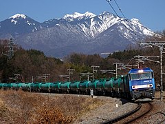
 Class E353 railcars on the Chūō main line
| |||||||||||||||||||||||||||||||||||||||||||||||||||||||||||||||||||||||||||||||||||||||||||||||||||||||||||||||||||||||||||||||||||||||||||||||||||||||||||||||||||||||||||||||||||||||||||||||||||||||||||||||||||||||||||||||||||||||||||||||||||||||||||||||||||||||||||||||||||||||||||||||||||||||||||||||||||||||||||||||||||||||||||||||||||||||||||||||||||||||||||||||||||||||||||||||||||||||||||||||||||||||||||||||||||||||||||||||||||||||||||||||||||||||||||||||||||||||||||||||||||||||||||||||||||||||||||||||||||||||||||||||||||||||||||||||||||||||||||||||||||||||||||||||||||||||||||||||||||||||||||||||||||||||||||||||||||||||||||||||||||||||||||||||||||||||||||||||||||||||||||||||||||||||||||||||||||||||||||||||||||||||||||||||||||||||||||||||||||||||||||||||||||||||||||||||||||||||||||||||||||||||||||||||||||||||||||||||||||||||||||||||||||||||||||||||||||||||||||||||||||||||||||||||||||||||||||||||||||||||||||||||||||||||||||||||||||||||||||||||||||||||||||||||||||||||||||||||||||||||
 | |||||||||||||||||||||||||||||||||||||||||||||||||||||||||||||||||||||||||||||||||||||||||||||||||||||||||||||||||||||||||||||||||||||||||||||||||||||||||||||||||||||||||||||||||||||||||||||||||||||||||||||||||||||||||||||||||||||||||||||||||||||||||||||||||||||||||||||||||||||||||||||||||||||||||||||||||||||||||||||||||||||||||||||||||||||||||||||||||||||||||||||||||||||||||||||||||||||||||||||||||||||||||||||||||||||||||||||||||||||||||||||||||||||||||||||||||||||||||||||||||||||||||||||||||||||||||||||||||||||||||||||||||||||||||||||||||||||||||||||||||||||||||||||||||||||||||||||||||||||||||||||||||||||||||||||||||||||||||||||||||||||||||||||||||||||||||||||||||||||||||||||||||||||||||||||||||||||||||||||||||||||||||||||||||||||||||||||||||||||||||||||||||||||||||||||||||||||||||||||||||||||||||||||||||||||||||||||||||||||||||||||||||||||||||||||||||||||||||||||||||||||||||||||||||||||||||||||||||||||||||||||||||||||||||||||||||||||||||||||||||||||||||||||||||||||||||||||||||||||||
| Route length: | 396.6 km + 27.7 km | ||||||||||||||||||||||||||||||||||||||||||||||||||||||||||||||||||||||||||||||||||||||||||||||||||||||||||||||||||||||||||||||||||||||||||||||||||||||||||||||||||||||||||||||||||||||||||||||||||||||||||||||||||||||||||||||||||||||||||||||||||||||||||||||||||||||||||||||||||||||||||||||||||||||||||||||||||||||||||||||||||||||||||||||||||||||||||||||||||||||||||||||||||||||||||||||||||||||||||||||||||||||||||||||||||||||||||||||||||||||||||||||||||||||||||||||||||||||||||||||||||||||||||||||||||||||||||||||||||||||||||||||||||||||||||||||||||||||||||||||||||||||||||||||||||||||||||||||||||||||||||||||||||||||||||||||||||||||||||||||||||||||||||||||||||||||||||||||||||||||||||||||||||||||||||||||||||||||||||||||||||||||||||||||||||||||||||||||||||||||||||||||||||||||||||||||||||||||||||||||||||||||||||||||||||||||||||||||||||||||||||||||||||||||||||||||||||||||||||||||||||||||||||||||||||||||||||||||||||||||||||||||||||||||||||||||||||||||||||||||||||||||||||||||||||||||||||||||||||||||
| Gauge : | 1067 mm ( cape track ) | ||||||||||||||||||||||||||||||||||||||||||||||||||||||||||||||||||||||||||||||||||||||||||||||||||||||||||||||||||||||||||||||||||||||||||||||||||||||||||||||||||||||||||||||||||||||||||||||||||||||||||||||||||||||||||||||||||||||||||||||||||||||||||||||||||||||||||||||||||||||||||||||||||||||||||||||||||||||||||||||||||||||||||||||||||||||||||||||||||||||||||||||||||||||||||||||||||||||||||||||||||||||||||||||||||||||||||||||||||||||||||||||||||||||||||||||||||||||||||||||||||||||||||||||||||||||||||||||||||||||||||||||||||||||||||||||||||||||||||||||||||||||||||||||||||||||||||||||||||||||||||||||||||||||||||||||||||||||||||||||||||||||||||||||||||||||||||||||||||||||||||||||||||||||||||||||||||||||||||||||||||||||||||||||||||||||||||||||||||||||||||||||||||||||||||||||||||||||||||||||||||||||||||||||||||||||||||||||||||||||||||||||||||||||||||||||||||||||||||||||||||||||||||||||||||||||||||||||||||||||||||||||||||||||||||||||||||||||||||||||||||||||||||||||||||||||||||||||||||||||
| Power system : | 1500 V = | ||||||||||||||||||||||||||||||||||||||||||||||||||||||||||||||||||||||||||||||||||||||||||||||||||||||||||||||||||||||||||||||||||||||||||||||||||||||||||||||||||||||||||||||||||||||||||||||||||||||||||||||||||||||||||||||||||||||||||||||||||||||||||||||||||||||||||||||||||||||||||||||||||||||||||||||||||||||||||||||||||||||||||||||||||||||||||||||||||||||||||||||||||||||||||||||||||||||||||||||||||||||||||||||||||||||||||||||||||||||||||||||||||||||||||||||||||||||||||||||||||||||||||||||||||||||||||||||||||||||||||||||||||||||||||||||||||||||||||||||||||||||||||||||||||||||||||||||||||||||||||||||||||||||||||||||||||||||||||||||||||||||||||||||||||||||||||||||||||||||||||||||||||||||||||||||||||||||||||||||||||||||||||||||||||||||||||||||||||||||||||||||||||||||||||||||||||||||||||||||||||||||||||||||||||||||||||||||||||||||||||||||||||||||||||||||||||||||||||||||||||||||||||||||||||||||||||||||||||||||||||||||||||||||||||||||||||||||||||||||||||||||||||||||||||||||||||||||||||||||
| Maximum slope : | 25 ‰ | ||||||||||||||||||||||||||||||||||||||||||||||||||||||||||||||||||||||||||||||||||||||||||||||||||||||||||||||||||||||||||||||||||||||||||||||||||||||||||||||||||||||||||||||||||||||||||||||||||||||||||||||||||||||||||||||||||||||||||||||||||||||||||||||||||||||||||||||||||||||||||||||||||||||||||||||||||||||||||||||||||||||||||||||||||||||||||||||||||||||||||||||||||||||||||||||||||||||||||||||||||||||||||||||||||||||||||||||||||||||||||||||||||||||||||||||||||||||||||||||||||||||||||||||||||||||||||||||||||||||||||||||||||||||||||||||||||||||||||||||||||||||||||||||||||||||||||||||||||||||||||||||||||||||||||||||||||||||||||||||||||||||||||||||||||||||||||||||||||||||||||||||||||||||||||||||||||||||||||||||||||||||||||||||||||||||||||||||||||||||||||||||||||||||||||||||||||||||||||||||||||||||||||||||||||||||||||||||||||||||||||||||||||||||||||||||||||||||||||||||||||||||||||||||||||||||||||||||||||||||||||||||||||||||||||||||||||||||||||||||||||||||||||||||||||||||||||||||||||||||
| Top speed: | 130 km / h | ||||||||||||||||||||||||||||||||||||||||||||||||||||||||||||||||||||||||||||||||||||||||||||||||||||||||||||||||||||||||||||||||||||||||||||||||||||||||||||||||||||||||||||||||||||||||||||||||||||||||||||||||||||||||||||||||||||||||||||||||||||||||||||||||||||||||||||||||||||||||||||||||||||||||||||||||||||||||||||||||||||||||||||||||||||||||||||||||||||||||||||||||||||||||||||||||||||||||||||||||||||||||||||||||||||||||||||||||||||||||||||||||||||||||||||||||||||||||||||||||||||||||||||||||||||||||||||||||||||||||||||||||||||||||||||||||||||||||||||||||||||||||||||||||||||||||||||||||||||||||||||||||||||||||||||||||||||||||||||||||||||||||||||||||||||||||||||||||||||||||||||||||||||||||||||||||||||||||||||||||||||||||||||||||||||||||||||||||||||||||||||||||||||||||||||||||||||||||||||||||||||||||||||||||||||||||||||||||||||||||||||||||||||||||||||||||||||||||||||||||||||||||||||||||||||||||||||||||||||||||||||||||||||||||||||||||||||||||||||||||||||||||||||||||||||||||||||||||||||||
| Dual track : | partially | ||||||||||||||||||||||||||||||||||||||||||||||||||||||||||||||||||||||||||||||||||||||||||||||||||||||||||||||||||||||||||||||||||||||||||||||||||||||||||||||||||||||||||||||||||||||||||||||||||||||||||||||||||||||||||||||||||||||||||||||||||||||||||||||||||||||||||||||||||||||||||||||||||||||||||||||||||||||||||||||||||||||||||||||||||||||||||||||||||||||||||||||||||||||||||||||||||||||||||||||||||||||||||||||||||||||||||||||||||||||||||||||||||||||||||||||||||||||||||||||||||||||||||||||||||||||||||||||||||||||||||||||||||||||||||||||||||||||||||||||||||||||||||||||||||||||||||||||||||||||||||||||||||||||||||||||||||||||||||||||||||||||||||||||||||||||||||||||||||||||||||||||||||||||||||||||||||||||||||||||||||||||||||||||||||||||||||||||||||||||||||||||||||||||||||||||||||||||||||||||||||||||||||||||||||||||||||||||||||||||||||||||||||||||||||||||||||||||||||||||||||||||||||||||||||||||||||||||||||||||||||||||||||||||||||||||||||||||||||||||||||||||||||||||||||||||||||||||||||||||
| Society: | JR Central / JR East | ||||||||||||||||||||||||||||||||||||||||||||||||||||||||||||||||||||||||||||||||||||||||||||||||||||||||||||||||||||||||||||||||||||||||||||||||||||||||||||||||||||||||||||||||||||||||||||||||||||||||||||||||||||||||||||||||||||||||||||||||||||||||||||||||||||||||||||||||||||||||||||||||||||||||||||||||||||||||||||||||||||||||||||||||||||||||||||||||||||||||||||||||||||||||||||||||||||||||||||||||||||||||||||||||||||||||||||||||||||||||||||||||||||||||||||||||||||||||||||||||||||||||||||||||||||||||||||||||||||||||||||||||||||||||||||||||||||||||||||||||||||||||||||||||||||||||||||||||||||||||||||||||||||||||||||||||||||||||||||||||||||||||||||||||||||||||||||||||||||||||||||||||||||||||||||||||||||||||||||||||||||||||||||||||||||||||||||||||||||||||||||||||||||||||||||||||||||||||||||||||||||||||||||||||||||||||||||||||||||||||||||||||||||||||||||||||||||||||||||||||||||||||||||||||||||||||||||||||||||||||||||||||||||||||||||||||||||||||||||||||||||||||||||||||||||||||||||||||||||||
|
|||||||||||||||||||||||||||||||||||||||||||||||||||||||||||||||||||||||||||||||||||||||||||||||||||||||||||||||||||||||||||||||||||||||||||||||||||||||||||||||||||||||||||||||||||||||||||||||||||||||||||||||||||||||||||||||||||||||||||||||||||||||||||||||||||||||||||||||||||||||||||||||||||||||||||||||||||||||||||||||||||||||||||||||||||||||||||||||||||||||||||||||||||||||||||||||||||||||||||||||||||||||||||||||||||||||||||||||||||||||||||||||||||||||||||||||||||||||||||||||||||||||||||||||||||||||||||||||||||||||||||||||||||||||||||||||||||||||||||||||||||||||||||||||||||||||||||||||||||||||||||||||||||||||||||||||||||||||||||||||||||||||||||||||||||||||||||||||||||||||||||||||||||||||||||||||||||||||||||||||||||||||||||||||||||||||||||||||||||||||||||||||||||||||||||||||||||||||||||||||||||||||||||||||||||||||||||||||||||||||||||||||||||||||||||||||||||||||||||||||||||||||||||||||||||||||||||||||||||||||||||||||||||||||||||||||||||||||||||||||||||||||||||||||||||||||||||||||||||||||
The Chūō main line (Japanese 中央 本 線 , Chūō-honsen ) is a railway line in the center of the Japanese island of Honshū and one of the most important railways in the country. It is one of three connections between Tokyo and Nagoya , alongside the Tōkaidō Shinkansen and the Tōkaidō main line . Of these, it is the slowest, as it leads outside of the metropolitan areas mainly on a winding route through mountainous terrain inland.
Passenger traffic is the responsibility of two companies in the JR Group : On the "Chūō East Line" ( 中央 東線 , Chūō-tōsen ) between Tokyo and Shiojiri , trains from JR East operate , on the subsequent "Chūō West Line" ( 中央 西 線 , Chūō-saisen ) to Nagoya trains from JR Central . There are no continuous connections between the endpoints, which are almost four hundred kilometers apart. JR Freight is responsible for freight transport . The fully electrified line in Tokyo is partially expanded to four tracks, there are also double-track and longer single-track sections.
This article deals with the main Chūō line in general. The urban part in the Tokyo metropolitan area is described in the articles Chūō-Schnellbahnlinie and Chūō-Sōbu-Linie .
general characteristics

The Chūō main line, laid in Cape Gauge (1067 mm) and fully electrified with 1500 V DC , extends over a distance of 396.9 km between the megacities of Tokyo and Nagoya . In contrast to the Tōkaidō main line, it does not run along the coast, but inland through mountain valleys and over plateaus in the Japanese Alps . It passes through the prefectures of Tokyo , Kanagawa , Yamanashi , Nagano , Gifu and Aichi or the regions of Kantō and Chūbu . There is also a 27.7 km long branch route from Okaya via Tatsuno to Shiojiri .
In the western suburbs of Tokyo, the section between Ochanomizu and Mitaka stations is by far the most frequented. He is relieved by the parallel Chūō-Sōbu line , which takes up all local traffic in this area. Only express and express trains, local trains between Mitaka and Takao as well as a few local trains between Tokyo and Mitaka run on the actual Chūō main line in the Tokyo area (for more on this see Chūō high-speed train line ).
While the Ochanomizu – Mitaka section has four tracks, the following sections are double-tracked: Tokyo –Ochanomizu, Mitaka – Takao – Fumonji, Okaya – Shiojiri – Niekawa, Narai – Miyanokoshi, Harano – Kuramoto and Jūnikane – Nagoya . All other sections are single-track; they are: Fumonji – Okaya – Tatsuno – Shiojiri, Niekawa – Narai, Miyanokoshi – Harano and Kuramoto – Jūnikane. A special feature of the Chūō main line west of Takao is the smaller clearance profile compared to most other Japanese railway lines . While the width is the same (3,000 mm), the height is only 3,900 mm instead of the usual 4,100 mm. Technological advances in the development of pantographs have made the use of differently built vehicles largely superfluous.
Route description
From Tokyo Station , the Chūō Main Line initially follows the Yamanote Line northwards , turns west and meets the Chūō-Sōbu Line at Ochanomizu Station , where the four-track section begins, leading to Mitaka Station . It crosses the western districts of Tokyo via the important Shinjuku hub station . After Tachikawa Station , the Tama and Asakawa rivers are bridged . The transition between the urban and the rural part of the Chūō main line is the Takao station , just before the border with Yamanashi Prefecture.
The Chūō Expressway and the upper reaches of the Sagami following, has the routing increasingly the character of a mountain railway on, with numerous curves and tunnels. After passing the Sasago tunnel (4856 m), the route enters the largely flat Kofu basin , with the provincial capital Kofu in its center. We continue northwest through the Kamanashi Valley , at the end of which we cross the border with Nagano Prefecture. In Station Fujimi is at 956 m TP the highest point reaches; it is also the highest express train stop in the country.
After circumnavigating Lake Suwa on its north side, the main Chūō line branches into two branches. The newer one leads through the Enrei tunnel (5994 m) directly to Shiojiri station . The older, 16 km longer route initially follows the upper reaches of the Tenryū in a south-westerly direction , before turning north at Tatsuno station (on the edge of the Ina basin ) and also reaching Shiojiri station. This also forms the border between the areas of responsibility of JR East and JR Central, while JR Freight maintains a marshalling yard here. The few passenger trains that change from the east to the west with a stop in Shiojiri have to turn around. Usually, through traffic is directed to the subsequent Shinonoi Line .
From Shiojiri, the Chūō main line runs in a south-westerly direction, first through the Narai valley and, after crossing under the Torii pass, through the scenic upper Kiso valley. Here too, numerous curves and tunnels (including the 2157 m long Torii tunnel) give the route the character of a mountain railway. After crossing the border with Gifu Prefecture, you will arrive at Nakatsugawa Station . From here the route is significantly flatter; shortly after the Tajimi station it leads through the Aigi tunnel (2910 m) and reaches the Nōbi plain in the prefecture of Aichi and the densely populated metropolitan region of Nagoya. After bridging the Shōnai , the city center is bypassed on its east and south sides. Finally, the route ends at Nagoya Station .

Katsuragawa Bridge at Torisawa
Freight train at Kobuchizawa

Shinano express train between Agematsu and Kuramoto

Bridge over the Kiso near Ochiaigawa
Aigi tunnel

Yadagawa Bridge in Nagoya


Trains
Two companies in the JR Group divide the Chūō main line in passenger traffic. JR Central is responsible between Shiojiri and Nagoya , the section east of it to Tokyo falls under the jurisdiction of JR East . That train connections in Shiojiri change from the "Chūō-west line" ( 中央 西 線 , Chūō-saisen ) to the "Chūō-east line" ( 中央 東線 , Chūō-tōsen ) and vice versa rarely happens. Such cases are usually limited to a few tourist excursion trains in the summer months. In 2018 this affected the Kiso Asuza ( 木 曽 あ ず さ ) from Tokyo to Nagiso and the Suwa Shinano ( 諏 訪 し な の ) from Nagoya to Kobuchizawa . There are no continuous connections from Tokyo to Nagoya.
JR East

The main load of the national long-distance traffic of JR East is carried by the express train Azusa ( あ ず さ ). 14 pairs of trains a day allow an hourly service from Shinjuku via Kofu and Okaya to Shiojiri and on the Shinonoi line to Matsumoto . One pair of trains each day connects Tokyo with Matsumoto, Shinjuku with Minami-Otari (on the Ōito line ), Chiba with Matsumoto and Chiba with Minami-Otari. Until the timetable change in March 2019, there was the Super Azusa ( ス ー, ー あ ず さ ), which used the latest generation of tilting trains . After the other trains were also switched to these cars, the distinction was no longer made. The express train Kaiji ( か い じ ) connects the Shinjuku and Kōfu stations twelve times a day , plus two pairs of express trains Fuji Kaiyū ( 富士 回遊 ) from Shinjuku to Kawaguchiko on the Fujikyūkō line . Another daily pair of express trains , the Misuzu ( み す ず ), runs from Nagano via Matsumoto, Shiojiri and Tatsuno to Iida on the Iida Line and back. In addition, the Narita Express ( 成 田 エ ク ス プ レ verbindet ) connects Takao with Tokyo Narita Airport once a day .
Local traffic on the part of the Chūō main line in Tokyo Prefecture is one of the densest in the entire country. It consists of a complex system of express and local trains, some of which also use the lines connected to it. More information can be found in the articles Chūō-Schnellbahnlinie and Chūō-Sōbu-Linie . Takao forms the interface between urban and rural local transport, even if several local trains are connected to Ōtsuki . To the west of it they run to Shiojiri every 30 to 60 minutes. The hourly regional trains in the Okaya – Tatsuno section are in most cases forwarded to the Iida line and go to Iida or Tenryūkyō (they are operated by JR Central). The Tatsuno – Shiojiri section is driven approximately every one to two hours.
JR Central

JR Central offers 13 pairs of trains on the Shinano ( し な の ) express train daily for long-distance services . These run every hour from Nagoya via Nakatsugawa , Shiojiri and Matsumoto to Nagano. During the main season, additional trains to Matsumoto and Hakuba on the Ōito line are offered from Nagoya .
Local traffic between Nagoya and Nakatsugawa operates on a tight schedule. Three express and five regional trains are offered every hour, some of which already turn in Kōzōji , Tajimi or Mizunami. In addition, there are several home liners , express trains with reserved seats during rush hour . The Nakatsugawa – Shiojiri section leads through sparsely populated areas, so the local transport offer is comparatively low. Usually there is a train every two hours during the day, and about every hour between Nakatsugawa and Nagiso.
Freight transport
Regular freight trains usually travel on two sections of the Chūō main line: on the one hand from Kunitachi in western Tokyo (confluence of the Musashino line ) to Minami-Matsumoto (north of Shiojiri on the Shinonoi line), on the other hand from Inazawa near Nagoya to Minami- Matsumoto. The intermediate destinations include loading stations in Hachiōji, Ryūō (near Kōfu) and Tajimi, until 2009 there were also freight trains to Tatsuno. Tank car trains loaded with heating and fuel also run regularly from various refineries on the coast to tank farms in the prefectures of Yamanashi and Nagano. Additional container trains are used between Inazawa and Kasugai to transport the products of a paper mill.
history
Preliminary project and commissioning
When the Tōkaidō main line emerged in the 1870s and 1880s, the Imperial Japanese Army wanted to enforce a route that would run as far inland as possible away from the coast, so that it would be easier to defend in the event of war. It proposed a railway line between Nagoya and Tokyo along the historic Nakasendō Street. In June 1885 the government approved plans. A year later, after more detailed investigations, the state railway administration came to the conclusion that the construction of this route would take more than ten years due to the numerous tunnels necessary and would exceed the financial possibilities of the state. The crossing of the Usui Pass in particular seemed too challenging at the time. The government ignored the wishes of the army and decided in July 1886 to build the missing part of the Tōkaidō main line near the coast.
On April 11, 1889, the private railway company Kōbu Tetsudō opened the first section of the later Chūō main line. The route, then known as Shigai-sen ( 市街 線 , German “city line”), was initially used exclusively for suburban traffic and connected Shinjuku with Tachikawa . Exactly four months later, on August 11th, the route reached Hachiōji . At the time, Shinjuku was on the western outskirts of Tokyo, which is why the company strove to extend the route further into the center. For this purpose, she took the section from Shinjuku to Iidabashi into operation on October 9, 1894 , and on April 3, 1895, the provisional city-side terminus Iidamachi was reached.
The Kōbu Tetsudō played a pioneering role when it carried out the first electrification of a railroad in all of Japan on August 21, 1904 on the eleven-kilometer section between Iidamachi and Nakano . On December 31, 1904, she moved the city-side terminus to Ochanomizu station . After the Japanese Reichstag passed the law to nationalize the railways , the Kōbu Tetsudō went into state ownership on October 1, 1906. As a result, the State Railway Administration (later the Ministry of Railways ) controlled the entire corridor between Tokyo and Nagoya, which was established in the Railway Construction Act of 1892. As early as 1896 she had started construction work on the rest of the Chūō main line at both ends and put the line into operation in stages in the following years.
Completion and expansion


The construction progress from the west was as follows: on July 25, 1900 from Nagoya to Tajimi , then on December 21, 1902 to Nakatsugawa , on August 1, 1908 to Sakashita , on July 15, 1909 to Nagiso, on September 1 1909 to Nojiri, on December 1, 1909 to Suhara, on October 5, 1910 to Agematsu and on November 25, 1910 to Kiso-Fukushima . From Hachiōji in the east, the line advanced on August 1, 1901 via Takao to Uenohara, on June 1, 1902 to Torisawa, on October 1, 1902 to Ōtsuki and on February 1, 1903 to Kai-Yamato. This was also associated with the commissioning of the Sasago Tunnel , which was the longest tunnel in Japan until 1931. We continued from Kai-Yamano on June 11, 1903 to Kofu , on December 15, 1903 to Nirasaki, on December 21, 1904 to Fujimi , on November 25, 1905 to Okaya , on June 11, 1906 via Tatsuno to Shiojiri , on December 1, 1909 to Yabuhara and on October 5, 1910 to Miyanokoshi. With the gap between Miyanokoshi and Kiso-Fukushima closed on May 1, 1911, the second continuous rail connection between the metropolises of Tokyo and Nagoya was completed.
On April 19, 1908, the terminus of Ochanomizu was relocated to the temporary Shōheibashi terminus, and from April 1, 1912, the Tokyo line ended in Manseibashi station . With the extension from Manseibashi to Tokyo Station , which was put into operation on March 1, 1919 , the Chūō main line was completed. After the Iidamachi – Shinjuku section had already been expanded to double track in 1895, the double track extended to Nakano in 1906, to Kichijōji in 1910 , to Tachikawa in 1929 and to Takao in 1939. In contrast to the Kōbu Tetsudō, the state railway took a lot of time with electrification. From Nakano, it expanded the electrical operation in 1919 to Kichijōji, 1922 to Kokubunji , 1929 to Tachikawa, 1930 to Takao and 1931 to Kōfu. In the years 1925 to 1933, it expanded the Ochanomizu – Shinjuku line to four tracks. In 1927 it increased the contact wire voltage from 600 V to 1200 V, two years later to the 1500 V common in Japan.
On August 5, 1945, an American P-51 fighter plane shot at a passenger train heading for Nagano near the Inohana tunnel west of Takao , killing 52 people. From 1951 to 1959 the Japanese State Railways operated a 3.2 km long branch line between Mitaka and the temporary Musashino baseball stadium. The following two decades were marked by an extensive expansion program with which the state railway significantly increased the capacity of the Chūō main line. On the one hand it extended the four-track section to Mitaka (completed in 1969), on the other hand it extended several sections west of Takao to two tracks in the years 1962 to 1983. The centerpiece was the commissioning of a second tunnel tube in the Sasago Tunnel on December 12, 1966.
Further development
After an interruption of more than 30 years, the state railway continued electrification: from Kofu the contact wire extended to Kami-Suwa in 1964 and to Shiojiri in 1965; from Nagoya it extended to Mizunami in 1966 and to Nakatsugawa in 1968. With the conversion of the Nakatsugawa – Shiojiri section, the electrification of the Chūō main line was completed on May 27, 1973. The route between Okaya and Tatsuno made a long detour via Tatsuno to avoid a geologically problematic mountain ridge. After technological progress made it possible to drill through faults , work on the Enrei Tunnel began in 1969 . It opened on July 5, 1983 and enabled the distance to be shortened by 16 km and travel time to be reduced by 26 minutes.
As part of the state railroad privatization took place on April 1, 1987, the division of the Chūō main line on two successor companies. The eastern part between Tokyo and Shiojiri became the property of JR East , the western part between Shiojiri and Nagano went to JR Central , while JR Freight took over all freight traffic. On October 1, 2003, JR Central introduced one-man operation for regional trains on the section between Shiojiri and Nakatsugawa.
List of train stations
(For train stations between Tokyo and Takao, see Chūō rapid transit line )
| Surname | km | Connecting lines | location | place | prefecture | |
|---|---|---|---|---|---|---|
| Takao – Shiojiri (JR East) | ||||||
| JC24 | Takao ( 五郎 丸 ) | 53.1 |
Chūō rapid transit line Keiō Takao line |
Coord. | Hachiōji | Tokyo |
| JC25 | Sagamiko ( 相 模 湖 ) | 62.6 | Coord. | Sagamihara | Kanagawa | |
| JC26 | Fujino ( 藤 野 ) | 66.3 | Coord. | |||
| JC27 | Uenohara ( 上 野 原 ) | 69.8 | Coord. | Uenohara | Yamanashi | |
| JC28 | Shiotsu ( 四方 津 ) | 74.0 | Coord. | |||
| JC29 | Yanagawa ( 梁 川 ) | 77.6 | Coord. | Ōtsuki | ||
| JC30 | Torisawa ( 鳥 沢 ) | 81.2 | Coord. | |||
| JC32 | Saruhashi ( 猿 橋 ) | 85.3 | Coord. | |||
| JC32 | Ōtsuki ( 大 月 ) | 87.8 | Fuji Kyūkō Line | Coord. | ||
| Hatsukari ( 初 狩 ) | 93.9 | Coord. | ||||
| Sasago ( 笹 子 ) | 100.4 | Coord. | ||||
| Kai-Yamato ( 甲 斐 大 和 ) | 106.5 | Coord. | Koshu | |||
| Katsunuma-budōkyō ( 勝 沼 ぶ ど う 郷 ) | 112.5 | Coord. | ||||
| Enzan ( 塩 山 ) | 116.9 | Coord. | ||||
| Higashi-Yamanashi ( 東山 梨 ) | 120.1 | Coord. | Yamanashi | |||
| Yamanashishi ( 山 梨 市 ) | 122.2 | Coord. | ||||
| Kasugaichō ( 春日 居 町 ) | 125.0 | Coord. | Fuefuki | |||
| Isawa Onsen ( 石 和 温泉 ) | 127.8 | Coord. | ||||
| Sakaori ( 酒 折 ) | 131.2 | Coord. | Kofu | |||
| Kofu ( 甲 府 ) | 134.1 | Minobu line | Coord. | |||
| Ryūō ( 竜 王 ) | 138.6 | Coord. | Quay | |||
| Shiozaki ( 塩 崎 ) | 142.7 | Coord. | ||||
| Nirasaki ( 韮 崎 ) | 147.0 | Coord. | Nirasaki | |||
| Shimpu ( 新 府 ) | 151.2 | Coord. | ||||
| Anayama ( 穴 山 ) | 154.7 | Coord. | ||||
| Hinoharu ( 日 野 春 ) | 160.1 | Coord. | Hokuto | |||
| Nagasaka ( 長坂 ) | 166.3 | Coord. | ||||
| Kobuchizawa ( 小淵 沢 ) | 173.7 | Koumi line | Coord. | |||
| Shinano-Sakai ( 信 濃 境 ) | 178.2 | Coord. | Fujimi | Nagano | ||
| Fujimi ( 富士 見 ) | 182.9 | Coord. | ||||
| Suzurannosato ( す ず ら ん の 里 ) | 186.1 | Coord. | ||||
| Aoyagi ( 青 柳 ) | 188.0 | Coord. | Chinos | |||
| Chino ( 茅 野 ) | 195.2 | Coord. | ||||
| Kami-Suwa ( 上 諏 訪 ) | 201.9 | Coord. | Suwa | |||
| Shimo-Suwa ( 下 諏 訪 ) | 206.3 | Coord. | Shimosuwa | |||
| Okaya ( 岡 谷 ) | 210.4 | Tatsuno branch line | Coord. | Okaya | ||
| Midoriko ( み ど り 湖 ) | 218.2 | Coord. | Shiojiri | |||
| Shiojiri ( 塩 尻 ) | 222.1 | Tatsuno Branch Line Shinonoi Line |
Coord. | |||
| Tatsuno Branch Line (JR East) | ||||||
| Okaya ( 岡 谷 ) | 0.0 | Main line | Okaya | Nagano | ||
| Kawagishi ( 川 岸 ) | 3.5 | Coord. | ||||
| Tatsuno ( 辰 野 ) | 9.5 | Iida line | Coord. | Tatsuno | ||
| Shinano-Kawashima ( 信 濃 川島 ) | 13.9 | Coord. | ||||
| Ono ( 小野 ) | 17.8 | Coord. | ||||
| Shiojiri ( 塩 尻 ) | 27.7 | Main Shinonoi Line |
Shiojiri | |||
| Shiojiri – Nakatsugawa (JR Central) | ||||||
| Shiojiri ( 塩 尻 ) | 222.1 | Tatsuno Branch Shinonoi Line |
Shiojiri | Nagano | ||
| Seba ( 洗馬 ) | 226.3 | Coord. | ||||
| Hideshio ( 日出 塩 ) | 231.0 | Coord. | ||||
| Niekawa ( 贄 川 ) | 236.2 | Coord. | ||||
| Kiso-Hirasawa ( 木 曽 平 沢 ) | 241.4 | Coord. | ||||
| Narai ( 奈良 井 ) | 243.2 | Coord. | ||||
| Yabuhara ( 藪 原 ) | 249.8 | Coord. | Kiso-mura | |||
| Miyanokoshi ( 宮 ノ 越 ) | 255.5 | Coord. | Kiso-machi | |||
| Harano ( 原野 ) | 258.3 | Coord. | ||||
| CF30 | Kiso-Fukushima ( 木 曽 福島 ) | 263.8 | Coord. | |||
| CF29 | Agematsu ( 上 松 ) | 271.1 | Coord. | Agematsu | ||
| Kuramoto ( 倉 本 ) | 277.7 | Coord. | ||||
| Suhara ( 須 原 ) | 282.5 | Coord. | Ōkuwa | |||
| Ōkuwa ( 大 桑 ) | 285.8 | Coord. | ||||
| Nojiri ( 野 尻 ) | 288.8 | Coord. | ||||
| Jūnikane ( 十二 兼 ) | 292.5 | Coord. | Nagiso | |||
| CF23 | Nagiso ( 南 木 曽 ) | 298.0 | Coord. | |||
| Tadachi ( 田 立 ) | 304.3 | Coord. | ||||
| Sakashita ( 坂 下 ) | 307.1 | Coord. | Nakatsugawa | Gifu | ||
| Ochiaigawa ( 落 合川 ) | 313.2 | Coord. | ||||
| CF19 | Nakatsugawa ( 中 津 川 ) | 317.0 | Coord. | |||
| CF18 | Mino-Sakamoto ( 美 乃 坂 本 ) | 323.4 | Coord. | |||
| CF17 | Ena ( 恵 那 ) | 328.6 | Akechi line | Coord. | Ena | |
| CF16 | Takenami ( 武 並 ) | 334.0 | Coord. | |||
| CF15 | Kamado ( 釜 戸 ) | 339.4 | Coord. | Mizunami | ||
| CF14 | Mizunami ( 瑞 浪 ) | 346.8 | Coord. | |||
| CF13 | Tokishi ( 土 岐 市 ) | 353.7 | Coord. | Toki | ||
| CF12 | Tajimi ( 多 治 見 ) | 360.7 | Taita line | Coord. | Tajimi | |
| CF11 | Kokokei ( 古 虎 渓 ) | 365.3 | Coord. | |||
| CF10 | Jōkōji ( 定 光寺 ) | 368.8 | Coord. | Kasugai | Aichi | |
| CF09 | Kōzōji ( 高 蔵 寺 ) | 372.9 | Aichi ring line | Coord. | ||
| CF08 | Jinryō ( 神 領 ) | 376.1 | Coord. | |||
| CF07 | Kasugai ( 春日 井 ) | 378.8 | Coord. | |||
| CF06 | Kachigawa ( 勝 川 ) | 381.9 | Jōhoku line | Coord. | ||
| CF05 | Shin-Moriyama ( 新 守 山 ) | 384.6 | Coord. | Nagoya | ||
| CF04 | Ōzone ( 大 曽 根 ) | 387.1 |
Meitetsu Seto Line Subway: Meijō Line Tracked Bus : Yutorito Line |
Coord. | ||
| CF03 | Chikusa ( 千種 ) | 389.8 | Subway: Higashiyama Line | Coord. | ||
| CF02 | Tsurumai ( 鶴 舞 ) | 391.3 | Subway: Tsurumai Line | Coord. | ||
| CF01 | Kanayama ( 金山 ) | 393.6 |
Tōkaidō Main Line Meitetsu Nagoya Main Line |
Coord. | ||
| CF00 | Nagoya ( 名古屋 ) | 396.9 |
Tōkaidō Shinkansen Kansai Main Line Tōkaidō Main Line Aonami Line in the subway station. Nagoya: Higashiyama Line Sakuradōri Line at Kintetsu Station Nagoya : Kintetsu Nagoya Line at Meitetsu Nagoya Station : Meitetsu Nagoya Main Line |
Coord. | ||
literature
- Dan Free: Early Japanese Railways 1853-1914: Engineering Triumphs That Transformed Meiji-era Japan . Turtle Publishing, Clarendon 2014, ISBN 978-4-8053-1290-2 .
- Kenji Nakamura: 中央 線 誕生 - 甲 武 鉄 道 の 開業 に 賭 け た 挑 戦 者 た ち . Honnofūkeisha, Tokyo 2003, ISBN 978-4-925187-31-2 .
- 中部 ラ イ ン - 全線 ・ 全 駅 ・ 全 配線 . 3 八 王子 駅 - 松本 エ リ ア. Kōdansha, Bunkyō 2010, ISBN 978-4-06-270063-4 .
- 中部 ラ イ ン - 全線 ・ 全 駅 ・ 全 配線 . 4 塩 尻 駅 - 名古屋 東部 エ リ ア. Kōdansha, Bunkyō 2010, ISBN 978-4-06-270064-1 .
Web links
- Information on the Chūō Main Line (English)
- Train stations information (Japanese)
Individual evidence
- ↑ Hiroshi Kubota: 鉄 道 工 学 ハ ン ド ブ ッ ク . Railway technology manual. Grand Prix, Chiyoda 1997, ISBN 4-87687-163-9 , pp. 148 .
- ↑ 夏 の 増 発 列車 の お 知 ら せ. (PDF, 1.4 MB) JR East , May 18, 2018, accessed May 25, 2019 (Japanese).
- ↑ a b c d e JR 時刻表 2018 年 3 月 号 (JR timetable March 2018). Kōtsū shinbunsha, Tokyo 2018.
- ↑ 2019 年 3 月 ダ イ ヤ 改正 に つ い て. (PDF, 783 kB) JR East , December 14, 2018, accessed May 25, 2019 (Japanese).
- ↑ Tetsudō fan . Koyusha, Naha July 2009, pp. 50 .
- ↑ さ ら ば い に し え の ジ ョ イ ン ト 音 . In: Tetsudō Fan . Koyusha, Naha July 2012, pp. 73 .
- ↑ Free: Early Japanese Railways 1853-1914. Pp. 110-111.
- ↑ Free: Early Japanese Railways 1853-1914. Pp. 125-127.
- ↑ 甲 武 鉄 道 新宿 八 王子 間 開通 祝賀 式. In: Yomiuri Shimbun . National Parliamentary Library digital archive , August 14, 1889, accessed May 25, 2019 (Japanese).
- ↑ 運輸 開業 免 許 状 下 付. In: Official Gazette. National Library of Parliament, April 6, 1895, accessed May 25, 2019 (Japanese).
- ↑ 電車 開始 並 停車場 設置. In: Official Gazette. National Library of Parliament, August 29, 1904, accessed May 25, 2019 (Japanese).
- ↑ 電車 運 転 開始. In: Official Gazette. National Library of Parliament, January 12, 1905, accessed May 25, 2019 (Japanese).
- ↑ Eiichi Aoki: 鉄 道 の 地理学 . WAVE Publishing, Chiyoda 2008, ISBN 978-4-87290-376-8 , pp. 94 .
- ↑ a b Tamotsu Imada: 中央 本 線 歴 史 の 興味 . In: Tetsudō Pikutoriaru . No. 869 . Denkisha kenkyūkai, Chiyoda November 2012, p. 10-23 .
- ↑ 都市化 の 進展 と 鉄 道 技術 の 導入. Japanese Institute for Economic Development, accessed May 25, 2019 (Japanese).
- ↑ Tomimura Sasaki, Ryōichi Amitani: 続 事故 の 鉄 道 史 . Nipponkeizai hyōron-sha, Chiyoda 1995, p. 77-91 .
- ↑ 中央 本 線 三 鷹 ・ 武 蔵 野 競技場 前 間 の 運輸 営 業 は 廃 止 す る 件 (Public Notice No. 386). Japanese State Railways , October 26, 1959.
- ↑ Yuishiro Kichi: The Central Highlands and Hokuriku Regions. (PDF, 1.5 MB) In: Railway Operators in Japan 9. East Japan Railway Culture Foundation, July 2003, accessed on May 25, 2019 .
- ↑ Tetsu Ishino (Ed.): 停車場 変 遷 大事 典 国 鉄 ・ JR 編 . JTB, Tokyo 1998, ISBN 4-533-02980-9 (station change directory JNR / JR).
Current lines: Tōkaidō-Shinkansen | Chūō main line | Gotemba Line | Iida line | Jōhoku Line | Kansai main line | Kisei main line | Meishō Line | Mino Akasaka Line | Minobu Line | Sangu line | Taita line | Takayama main line | Taketoyo line | Tōkaidō main line ( Atami – Toyohashi , Toyohashi – Maibara )
Released Lines: Nishi Nagoyakō Line | Okata line
Shinkansen: Akita Shinkansen | Gala Yuzawa Line | Hokuriku Shinkansen | Jōetsu Shinkansen | Tōhoku Shinkansen | Yamagata Shinkansen
Lines in Greater Tokyo: Akabane Line | Chūō Main Line ( Chūō Rapid Railway Line , Chūō-Sōbu Line ) | Hachikō line | Itsukaichi line | Jōban line | Jōetsu line | Kashima line | Kawagoe line | Keihin Tōhoku Line | Keiyō line | Kururi line | Narita line | Mito line | Musashino line | Nambu line | Negishi line | Ōme line | Ryōmō Line | Sagami line | Saikyō Line | Shōnan Shinjuku Line | Sōbu Main Line ( Sōbu Rapid Train Line ) | Sotobō Line | Takasaki Line | Tōgane Line | Tōhoku Main Line ( Utsunomiya Line ) | Tōkaidō main line ( Tokyo – Atami ) | Tsurumi line | Uchibō Line | Ueno Tokyo Line | Yamanote Line | Yokohama Line | Yokosuka line
Lines in other regions: Agatsuma Line | Aterazawa Line | Ban'etsu East Line | Ban'etsu West Line | Echigo line | Gonō line | Hachinohe Line | Hakushin Line | Hanawa line | Iiyama line | Ishinomaki Line | Itō line | Kamaishi line | Karasuyama Line | Kesennuma Line | Kitakami line | Koumi line | Nikko Line | Ōito line | Ōfunato line | Oga line | Ōminato line | Ōu main line | Rifu line | Rikuu East Line | Rikuu West Line | Senseki line | Senseki-Tōhoku Line | Senzan Line | Shin'etsu main line | Shinonoi line | Suigun line | Tadami line | Tazawako Line | Tsugaru Line | Uetsu main line | Yahiko line | Yamada line | Yonesaka line