
Minobu line
| Minobu line | |||||||||||||||||||||||||||||||||||||||||||||||||||||||||||||||||||||||||||||||||||||||||||||||||||||||||||||||||||||||||||||||||||||||||||||||||||||||||||||||||||||||||||||||||||||||||||||||||||||||||||||||||||||||||||||||||||||||||||||||||||||||||||||||||||||||||||||||||||||||||||||||||||||||||||||||||||||||||||||||||||||
|---|---|---|---|---|---|---|---|---|---|---|---|---|---|---|---|---|---|---|---|---|---|---|---|---|---|---|---|---|---|---|---|---|---|---|---|---|---|---|---|---|---|---|---|---|---|---|---|---|---|---|---|---|---|---|---|---|---|---|---|---|---|---|---|---|---|---|---|---|---|---|---|---|---|---|---|---|---|---|---|---|---|---|---|---|---|---|---|---|---|---|---|---|---|---|---|---|---|---|---|---|---|---|---|---|---|---|---|---|---|---|---|---|---|---|---|---|---|---|---|---|---|---|---|---|---|---|---|---|---|---|---|---|---|---|---|---|---|---|---|---|---|---|---|---|---|---|---|---|---|---|---|---|---|---|---|---|---|---|---|---|---|---|---|---|---|---|---|---|---|---|---|---|---|---|---|---|---|---|---|---|---|---|---|---|---|---|---|---|---|---|---|---|---|---|---|---|---|---|---|---|---|---|---|---|---|---|---|---|---|---|---|---|---|---|---|---|---|---|---|---|---|---|---|---|---|---|---|---|---|---|---|---|---|---|---|---|---|---|---|---|---|---|---|---|---|---|---|---|---|---|---|---|---|---|---|---|---|---|---|---|---|---|---|---|---|---|---|---|---|---|---|---|---|---|---|---|---|---|---|---|---|---|---|---|---|---|---|---|---|---|---|---|---|---|---|---|---|---|---|---|---|---|---|---|---|---|---|---|---|---|---|---|---|---|---|---|---|---|---|---|---|---|---|---|---|
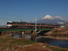
 Class 373 multiple unit with Mount Fuji in the background
| |||||||||||||||||||||||||||||||||||||||||||||||||||||||||||||||||||||||||||||||||||||||||||||||||||||||||||||||||||||||||||||||||||||||||||||||||||||||||||||||||||||||||||||||||||||||||||||||||||||||||||||||||||||||||||||||||||||||||||||||||||||||||||||||||||||||||||||||||||||||||||||||||||||||||||||||||||||||||||||||||||||
 | |||||||||||||||||||||||||||||||||||||||||||||||||||||||||||||||||||||||||||||||||||||||||||||||||||||||||||||||||||||||||||||||||||||||||||||||||||||||||||||||||||||||||||||||||||||||||||||||||||||||||||||||||||||||||||||||||||||||||||||||||||||||||||||||||||||||||||||||||||||||||||||||||||||||||||||||||||||||||||||||||||||
| Route length: | 88.4 km | ||||||||||||||||||||||||||||||||||||||||||||||||||||||||||||||||||||||||||||||||||||||||||||||||||||||||||||||||||||||||||||||||||||||||||||||||||||||||||||||||||||||||||||||||||||||||||||||||||||||||||||||||||||||||||||||||||||||||||||||||||||||||||||||||||||||||||||||||||||||||||||||||||||||||||||||||||||||||||||||||||||
| Gauge : | 1067 mm ( cape track ) | ||||||||||||||||||||||||||||||||||||||||||||||||||||||||||||||||||||||||||||||||||||||||||||||||||||||||||||||||||||||||||||||||||||||||||||||||||||||||||||||||||||||||||||||||||||||||||||||||||||||||||||||||||||||||||||||||||||||||||||||||||||||||||||||||||||||||||||||||||||||||||||||||||||||||||||||||||||||||||||||||||||
| Power system : | 1500 V = | ||||||||||||||||||||||||||||||||||||||||||||||||||||||||||||||||||||||||||||||||||||||||||||||||||||||||||||||||||||||||||||||||||||||||||||||||||||||||||||||||||||||||||||||||||||||||||||||||||||||||||||||||||||||||||||||||||||||||||||||||||||||||||||||||||||||||||||||||||||||||||||||||||||||||||||||||||||||||||||||||||||
| Maximum slope : | 25 ‰ | ||||||||||||||||||||||||||||||||||||||||||||||||||||||||||||||||||||||||||||||||||||||||||||||||||||||||||||||||||||||||||||||||||||||||||||||||||||||||||||||||||||||||||||||||||||||||||||||||||||||||||||||||||||||||||||||||||||||||||||||||||||||||||||||||||||||||||||||||||||||||||||||||||||||||||||||||||||||||||||||||||||
| Top speed: | 85 km / h | ||||||||||||||||||||||||||||||||||||||||||||||||||||||||||||||||||||||||||||||||||||||||||||||||||||||||||||||||||||||||||||||||||||||||||||||||||||||||||||||||||||||||||||||||||||||||||||||||||||||||||||||||||||||||||||||||||||||||||||||||||||||||||||||||||||||||||||||||||||||||||||||||||||||||||||||||||||||||||||||||||||
| Dual track : | Fuji-Fujinomiya | ||||||||||||||||||||||||||||||||||||||||||||||||||||||||||||||||||||||||||||||||||||||||||||||||||||||||||||||||||||||||||||||||||||||||||||||||||||||||||||||||||||||||||||||||||||||||||||||||||||||||||||||||||||||||||||||||||||||||||||||||||||||||||||||||||||||||||||||||||||||||||||||||||||||||||||||||||||||||||||||||||||
| Society: | JR Central | ||||||||||||||||||||||||||||||||||||||||||||||||||||||||||||||||||||||||||||||||||||||||||||||||||||||||||||||||||||||||||||||||||||||||||||||||||||||||||||||||||||||||||||||||||||||||||||||||||||||||||||||||||||||||||||||||||||||||||||||||||||||||||||||||||||||||||||||||||||||||||||||||||||||||||||||||||||||||||||||||||||
|
|||||||||||||||||||||||||||||||||||||||||||||||||||||||||||||||||||||||||||||||||||||||||||||||||||||||||||||||||||||||||||||||||||||||||||||||||||||||||||||||||||||||||||||||||||||||||||||||||||||||||||||||||||||||||||||||||||||||||||||||||||||||||||||||||||||||||||||||||||||||||||||||||||||||||||||||||||||||||||||||||||||
The Minobu Line ( Japanese 身 延 線 , Minobu-sen ) is a railway line on the Japanese island of Honshū , which is operated by the JR Central railway company . It runs from Fuji in Shizuoka Prefecture to Kofu in Yamanashi Prefecture . It establishes a cross connection between the Tōkaidō main line and the Chūō main line to the west of the Fuji volcano .
description
The Minobu line laid in Kapspur (1067 mm) is 88.4 km long and electrified with 1500 V direct current . It serves 39 train stations and stops and has a top speed of 85 km / h. The southern starting point is Fuji station on the Tōkaidō main line . The route initially runs north-west through the densely populated Urui Valley, with the first 10.7 km to Fujinomiya station being double-tracked. After the Nishi-Fujinomiya station and the second bridge over the Usui, the now single-track line turns south to reach the Fujikawa valley. The route then runs again in a north-westerly to north-westerly direction. Due to the location on the edge of the Akaishi Mountains , the construction of numerous tunnels was necessary. Among other things, the place Minobu is passed, after which the line is named. At Kajikazawaguchi the route reaches the shallow Kofu basin . Between the Zenkōji station and the Kōfu station , the northern end point, the Minobu line runs parallel to the Chūō main line .
Trains
Seven pairs of trains run daily on the Fujikawa express train ( ふ じ か わ ). From Kofu they drive on the entire Minobu line to Fuji and on to Shizuoka on the Tōkaidō main line . Class 373 railcars are used .
Of regional trains sections are often driven differently according to population density:
- Between Fuji and Nishi-Fujinomiya: one to three trains per hour (four trains per hour during rush hour)
- Between Nishi-Fujinomiya and Kajikazawaguchi: Every 1 to 2 hours, with trains in Shibakawa and Minobu taking longer breaks to let trains pass in the opposite direction.
- Between Kajikazawaguchi and Kofu: one to two trains per hour
history
Predecessor of minobu line was from the paper company Fuji Seishi built Fuji Pferdebahn ( 富士馬車鉄道 , Fuji Basha tetsudō ) of Yoshiwara on the Tōkaidō Main Line to Ōmiya (now Fujinomiya ). It was 14.1 km long, had a track width of 609 mm and partly followed the historic Tōkaidō Street. After its opening on June 26, 1890, it was used not only for local mail and passenger traffic, but above all for transporting wood to the paper mill in Yoshiwara. In 1908 the company was renamed Fuji Tetsudō . It opened a short branch line to Fuji Station on April 17, 1910 .
A group of entrepreneurs from Kofu founded the Fuji Minobu Tetsudō ( 富士 身 延 鉄 道 ) railway company in 1912 , the aim of which was to connect the cities of Kofu and Shizuoka . It took over the Fuji Tetsudō and built a Cape Gauge railway line for steam operation between Fuji and Fujinomiya. It opened on July 20, 1913 and the largely parallel section of the horse-drawn tram was shut down. In the following years the Fuji Minobu Tetsudō extended its route in several stages: on March 1, 1915 from Fujinomiya to Shibakawa, on August 10, 1918 to Tōshima, on October 8, 1918 to Utsubuna, on April 8, 1919 to Kai-Ōshima and on May 18, 1920 to Minobu .
In 1926, the Fuji Minobu Tetsudō decided to electrify the line; the corresponding work was completed on June 20, 1927. On December 17, 1927, the line from Minobu to Ichikawa-Daimon was extended, and on March 30, 1928, it finally reached the Kofu terminus . Several new stops were set up in the 1930s. On October 1, 1938, the Fuji Minobu Tetsudō concluded a leasing contract with the state and on May 1, 1941, the Ministry of Railways took over the newly designated Minobu line entirely. With the timetable change on March 20, 1964, the Japanese State Railways introduced the Fujikawa express train .
From 1960, the number of special trains chartered by the Buddhist lay movement Sōka Gakkai on the Minobu line began to increase significantly. They carried believers on their pilgrimage to Taiseki-ji , the main temple of the Nichiren Shōshū school. The special trains were soon so numerous that they massively impeded road traffic at the level crossing on Nationalstrasse 1 (today's Prefecture Road 396). The state railway therefore built a new double-track route in an elevated position between the Fuji and Tatebori stations, which went into operation on September 28, 1969. The old route through the city center of Fuji was redesigned into a two-kilometer-long, park-like promenade called Fuji Green Road . The state railway then expanded the following two-track sections: on March 28, 1971 between Fujinomiya and Fujine, on March 13, 1972 between Fujine and Iriyamase and on September 27, 1974 between Iriyamase and Tatebori. With the exclusion of Sōka Gakkai from the Nichiren Shōshū School in 1991, the number of special trains fell massively.
As part of the privatization of the state railway, the Minobu line was transferred to the new company JR Central on April 1, 1987 . On the same day, JR Freight took over the freight traffic between Kofu and Higashi-Hanawa, but stopped it on the rest of the route to Fuji. As a result of the load shedding after the Tōhoku earthquake , parts of the Minobu line were out of service from March 14 to April 8, 2011. On September 22, 2011, Typhoon Roke caused so much damage to the embankment that traffic had to be stopped for most of the route. While it could be resumed after four days between Minobu and Kofu, the repair between Nishi-Fujinomiya and Minobu dragged on until November 14, 2011. It was not until March 17, 2012 that the timetable could be fully implemented again.
photos
Fujikawa express train at Tatebori

Sidings at Fujinomiya Station

Local train in Minobu station

Railway crossing on the Minobu line


List of train stations
| Surname | km | Connecting lines | location | place | prefecture |
|---|---|---|---|---|---|
| Fuji ( 富士 ) | 0.0 | Main Tōkaidō line | Coord. | Fuji | Shizuoka |
| Yunoki ( 柚木 ) | 1.5 | Coord. | |||
| Tatebori ( 竪 堀 ) | 2.8 | Coord. | |||
| Iriyamase ( 入 山 瀬 ) | 5.6 | Coord. | |||
| Fujine ( 富士 根 ) | 8.0 | Coord. | |||
| Gendōji ( 源 道 寺 ) | 9.3 | Coord. | Fujinomiya | ||
| Fujinomiya ( 富士 宮 ) | 10.7 | Coord. | |||
| Nishi-Fujinomiya ( 西 富士 宮 ) | 11.9 | Coord. | |||
| Numakubo ( 沼 久保 ) | 16.9 | Coord. | |||
| Shibakawa ( 芝 川 ) | 19.2 | Coord. | |||
| Inako ( 稲 子 ) | 24.0 | Coord. | |||
| Tōshima ( 十 島 ) | 26.3 | Coord. | Nambu | Yamanashi | |
| Ide ( 井 出 ) | 29.4 | Coord. | |||
| Yorihata ( 寄 畑 ) | 31.9 | Coord. | |||
| Utsubuna ( 内 船 ) | 34.1 | Coord. | |||
| Kai-Ōshima ( 甲 斐 大 島 ) | 39.8 | Coord. | Minobu | ||
| Minobu ( 身 延 ) | 43.5 | Coord. | |||
| Shionosawa ( 塩 之 沢 ) | 45.7 | Coord. | |||
| Hadakajima ( 波 高 島 ) | 50.2 | Coord. | |||
| Shimobe-onsen ( 下部 温泉 ) | 51.7 | Coord. | |||
| Kai-Tokiwa ( 甲 斐 常 葉 ) | 54.1 | Coord. | |||
| Ichinose ( 市 ノ 瀬 ) | 56.1 | Coord. | |||
| Kunado ( 久 那 土 ) | 58.8 | Coord. | |||
| Kai-Iwama ( 甲 斐 岩 間 ) | 60.3 | Coord. | Ichikawamisato | ||
| Ochii ( 落 居 ) | 61.8 | Coord. | |||
| Kajikazawaguchi ( 鰍 沢 口 ) | 66.8 | Coord. | |||
| Ichikawa daimon ( 市 川 大門 ) | 69.8 | Coord. | |||
| Ichikawa-Hommachi ( 市 川 本 町 ) | 70.7 | Coord. | |||
| Ashigawa ( 芦 川 ) | 71.7 | Coord. | |||
| Kai-Ueno ( 甲 斐 上 野 ) | 72.8 | Coord. | |||
| Higashi-Hanawa ( 東 花 輪 ) | 76.3 | Coord. | Chūō | ||
| Koikawa ( 小井 川 ) | 77.5 | Coord. | |||
| Jōei ( 常 永 ) | 78.9 | Coord. | Shōwa | ||
| Kokubo ( 国 母 ) | 81.2 | Coord. | Kofu | ||
| Kai-Sumiyoshi ( 甲 斐 住 吉 ) | 83.1 | Coord. | |||
| Minami-Kofu ( 南 甲 府 ) | 84.0 | Coord. | |||
| Zenkōji ( 善 光寺 ) | 86.3 | Coord. | |||
| Kanente ( 金 手 ) | 87.2 | Coord. | |||
| Kofu ( 甲 府 ) | 88.8 | Chūō main line | Coord. |
Web links
- JR Central route network (PDF, 1.2 MB)
Individual evidence
- ↑ JR 新 幹線 & 特急 列車 フ ァ イ ル . Kōtsū Shimbun, Tokyo 2008, ISBN 978-4-330-00608-6 , pp. 30-32 .
- ↑ JR 時刻表 2018 年 3 月 号 (JR timetable March 2018). Kōtsū shinbunsha, Tokyo 2018.
- ↑ History Commission of the City of Fuji (ed.): 鷹 岡 町 史 . Fuji 1984, p. 964 .
- ↑ Morio Nagi, Hideo Endo (Ed.): 目 で 見 る 富士 ・ 富士 宮 の 100 年 . Kyōdo shuppansha, Nagano 1990, ISBN 978-4-87665-026-2 , p. 45 .
- ↑ a b c Tetsu Ishino (Ed.): 停車場 変 遷 大事 典 国 鉄 ・ JR 編 1 . JTB, Tokyo 1998, ISBN 4-533-02980-9 (station change directory JNR / JR).
- ↑ 身 延 線 沿線 を ウ ロ ウ ロ… 1. 富士 緑 道 (前 半). 4travel.jp, October 26, 2015, accessed November 7, 2018 (Japanese).
- ↑ 【社長 会見】 身 延 線 全線 運 転 再 開 に つ い て. JR Central , February 15, 2012, accessed November 7, 2018 (Japanese).
Current lines: Tōkaidō-Shinkansen | Chūō main line | Gotemba Line | Iida line | Jōhoku Line | Kansai main line | Kisei main line | Meishō Line | Mino Akasaka Line | Minobu Line | Sangu line | Taita line | Takayama main line | Taketoyo line | Tōkaidō main line ( Atami – Toyohashi , Toyohashi – Maibara )
Released Lines: Nishi Nagoyakō Line | Okata line