
Tōkaidō main line (Toyohashi – Maibara)
| Tōkaidō main line (Toyohashi – Maibara) | |||||||||||||||||||||||||||||||||||||||||||||||||||||||||||||||||||||||||||||||||||||||||||||||||||||||||||||||||||||||||||||||||||||||||||||||||||||||||||||||||||||||||||||||||||||||||||||||||||||||||||||||||||||||||||||||||||||||||||||||||||||||||||||||||||||||||||||||||||||||||||||||||||||||||||||||||||||||||||||||||||||||||||||||||||||||||||||||||||||||||||||||||||||||||||||||||||||||||||||||||||||||||||||||||||||||||||||||||||||||||||||||||||||||||||||||||||||||||||||||||||||||||||||||||||||||||||||||||||||||||||||||||||||||||||||||||||||||||||||||||||||||||||||||||||||||||
|---|---|---|---|---|---|---|---|---|---|---|---|---|---|---|---|---|---|---|---|---|---|---|---|---|---|---|---|---|---|---|---|---|---|---|---|---|---|---|---|---|---|---|---|---|---|---|---|---|---|---|---|---|---|---|---|---|---|---|---|---|---|---|---|---|---|---|---|---|---|---|---|---|---|---|---|---|---|---|---|---|---|---|---|---|---|---|---|---|---|---|---|---|---|---|---|---|---|---|---|---|---|---|---|---|---|---|---|---|---|---|---|---|---|---|---|---|---|---|---|---|---|---|---|---|---|---|---|---|---|---|---|---|---|---|---|---|---|---|---|---|---|---|---|---|---|---|---|---|---|---|---|---|---|---|---|---|---|---|---|---|---|---|---|---|---|---|---|---|---|---|---|---|---|---|---|---|---|---|---|---|---|---|---|---|---|---|---|---|---|---|---|---|---|---|---|---|---|---|---|---|---|---|---|---|---|---|---|---|---|---|---|---|---|---|---|---|---|---|---|---|---|---|---|---|---|---|---|---|---|---|---|---|---|---|---|---|---|---|---|---|---|---|---|---|---|---|---|---|---|---|---|---|---|---|---|---|---|---|---|---|---|---|---|---|---|---|---|---|---|---|---|---|---|---|---|---|---|---|---|---|---|---|---|---|---|---|---|---|---|---|---|---|---|---|---|---|---|---|---|---|---|---|---|---|---|---|---|---|---|---|---|---|---|---|---|---|---|---|---|---|---|---|---|---|---|---|---|---|---|---|---|---|---|---|---|---|---|---|---|---|---|---|---|---|---|---|---|---|---|---|---|---|---|---|---|---|---|---|---|---|---|---|---|---|---|---|---|---|---|---|---|---|---|---|---|---|---|---|---|---|---|---|---|---|---|---|---|---|---|---|---|---|---|---|---|---|---|---|---|---|---|---|---|---|---|---|---|---|---|---|---|---|---|---|---|---|---|---|---|---|---|---|---|---|---|---|---|---|---|---|---|---|---|---|---|---|---|---|---|---|---|---|---|---|---|---|---|---|---|---|---|---|---|---|---|---|---|---|---|---|---|---|---|---|---|---|---|---|---|---|---|---|---|---|---|---|---|---|---|---|---|---|---|---|---|---|---|---|---|---|---|---|---|---|---|---|---|---|---|---|---|---|---|---|---|---|---|---|---|---|---|---|---|---|---|---|---|---|---|---|---|---|---|---|---|---|---|---|---|---|---|---|---|---|---|---|---|---|---|---|---|---|---|---|---|---|---|---|---|---|---|---|---|---|---|---|---|---|---|---|---|---|---|---|---|---|---|---|---|---|---|---|---|---|---|---|---|---|---|---|---|---|---|---|---|
 Bridge over the Kiso
| |||||||||||||||||||||||||||||||||||||||||||||||||||||||||||||||||||||||||||||||||||||||||||||||||||||||||||||||||||||||||||||||||||||||||||||||||||||||||||||||||||||||||||||||||||||||||||||||||||||||||||||||||||||||||||||||||||||||||||||||||||||||||||||||||||||||||||||||||||||||||||||||||||||||||||||||||||||||||||||||||||||||||||||||||||||||||||||||||||||||||||||||||||||||||||||||||||||||||||||||||||||||||||||||||||||||||||||||||||||||||||||||||||||||||||||||||||||||||||||||||||||||||||||||||||||||||||||||||||||||||||||||||||||||||||||||||||||||||||||||||||||||||||||||||||||||||
| Route length: | 152.3 km | ||||||||||||||||||||||||||||||||||||||||||||||||||||||||||||||||||||||||||||||||||||||||||||||||||||||||||||||||||||||||||||||||||||||||||||||||||||||||||||||||||||||||||||||||||||||||||||||||||||||||||||||||||||||||||||||||||||||||||||||||||||||||||||||||||||||||||||||||||||||||||||||||||||||||||||||||||||||||||||||||||||||||||||||||||||||||||||||||||||||||||||||||||||||||||||||||||||||||||||||||||||||||||||||||||||||||||||||||||||||||||||||||||||||||||||||||||||||||||||||||||||||||||||||||||||||||||||||||||||||||||||||||||||||||||||||||||||||||||||||||||||||||||||||||||||||||
| Gauge : | 1067 mm ( cape track ) | ||||||||||||||||||||||||||||||||||||||||||||||||||||||||||||||||||||||||||||||||||||||||||||||||||||||||||||||||||||||||||||||||||||||||||||||||||||||||||||||||||||||||||||||||||||||||||||||||||||||||||||||||||||||||||||||||||||||||||||||||||||||||||||||||||||||||||||||||||||||||||||||||||||||||||||||||||||||||||||||||||||||||||||||||||||||||||||||||||||||||||||||||||||||||||||||||||||||||||||||||||||||||||||||||||||||||||||||||||||||||||||||||||||||||||||||||||||||||||||||||||||||||||||||||||||||||||||||||||||||||||||||||||||||||||||||||||||||||||||||||||||||||||||||||||||||||
| Power system : | 1500 V = | ||||||||||||||||||||||||||||||||||||||||||||||||||||||||||||||||||||||||||||||||||||||||||||||||||||||||||||||||||||||||||||||||||||||||||||||||||||||||||||||||||||||||||||||||||||||||||||||||||||||||||||||||||||||||||||||||||||||||||||||||||||||||||||||||||||||||||||||||||||||||||||||||||||||||||||||||||||||||||||||||||||||||||||||||||||||||||||||||||||||||||||||||||||||||||||||||||||||||||||||||||||||||||||||||||||||||||||||||||||||||||||||||||||||||||||||||||||||||||||||||||||||||||||||||||||||||||||||||||||||||||||||||||||||||||||||||||||||||||||||||||||||||||||||||||||||||
| Top speed: | 120 km / h | ||||||||||||||||||||||||||||||||||||||||||||||||||||||||||||||||||||||||||||||||||||||||||||||||||||||||||||||||||||||||||||||||||||||||||||||||||||||||||||||||||||||||||||||||||||||||||||||||||||||||||||||||||||||||||||||||||||||||||||||||||||||||||||||||||||||||||||||||||||||||||||||||||||||||||||||||||||||||||||||||||||||||||||||||||||||||||||||||||||||||||||||||||||||||||||||||||||||||||||||||||||||||||||||||||||||||||||||||||||||||||||||||||||||||||||||||||||||||||||||||||||||||||||||||||||||||||||||||||||||||||||||||||||||||||||||||||||||||||||||||||||||||||||||||||||||||
| Dual track : | whole route | ||||||||||||||||||||||||||||||||||||||||||||||||||||||||||||||||||||||||||||||||||||||||||||||||||||||||||||||||||||||||||||||||||||||||||||||||||||||||||||||||||||||||||||||||||||||||||||||||||||||||||||||||||||||||||||||||||||||||||||||||||||||||||||||||||||||||||||||||||||||||||||||||||||||||||||||||||||||||||||||||||||||||||||||||||||||||||||||||||||||||||||||||||||||||||||||||||||||||||||||||||||||||||||||||||||||||||||||||||||||||||||||||||||||||||||||||||||||||||||||||||||||||||||||||||||||||||||||||||||||||||||||||||||||||||||||||||||||||||||||||||||||||||||||||||||||||
| Society: | JR Central | ||||||||||||||||||||||||||||||||||||||||||||||||||||||||||||||||||||||||||||||||||||||||||||||||||||||||||||||||||||||||||||||||||||||||||||||||||||||||||||||||||||||||||||||||||||||||||||||||||||||||||||||||||||||||||||||||||||||||||||||||||||||||||||||||||||||||||||||||||||||||||||||||||||||||||||||||||||||||||||||||||||||||||||||||||||||||||||||||||||||||||||||||||||||||||||||||||||||||||||||||||||||||||||||||||||||||||||||||||||||||||||||||||||||||||||||||||||||||||||||||||||||||||||||||||||||||||||||||||||||||||||||||||||||||||||||||||||||||||||||||||||||||||||||||||||||||
|
|||||||||||||||||||||||||||||||||||||||||||||||||||||||||||||||||||||||||||||||||||||||||||||||||||||||||||||||||||||||||||||||||||||||||||||||||||||||||||||||||||||||||||||||||||||||||||||||||||||||||||||||||||||||||||||||||||||||||||||||||||||||||||||||||||||||||||||||||||||||||||||||||||||||||||||||||||||||||||||||||||||||||||||||||||||||||||||||||||||||||||||||||||||||||||||||||||||||||||||||||||||||||||||||||||||||||||||||||||||||||||||||||||||||||||||||||||||||||||||||||||||||||||||||||||||||||||||||||||||||||||||||||||||||||||||||||||||||||||||||||||||||||||||||||||||||||
This article describes the part of the Tōkaidō Main Line , one of the most important railway lines in Japan , located in the western half of the Chūbu region . The Cape-gauge section, centered on the city of Nagoya , is 152.3 km long and is operated by the JR Central railway company. From Toyohashi it leads via Nagoya and Gifu to Maibara . It crosses the prefectures Aichi and Gifu until it finally ends in the east of Shiga prefecture .
The general features and history of the entire Tokyo - Kobe route are covered in the main article. Further sections:
- Tōkaidō main line (Tokyo – Atami)
- Tōkaidō main line (Atami – Toyohashi)
- Biwako Line (Maibara – Kyōto)
- JR Kyōto Line (Kyōto – Osaka)
- JR Kobe Line (Osaka – Kobe)
Route description
The eastern starting point is Toyohashi Station . For the first three kilometers, the route initially runs northwards parallel to the Meitetsu Nagoya main line . In doing so, it bridges the Toyo and its relief channel. After the branching off of the Iida line , the Tōkaidō main line turns west and follows the north bank of Mikawa Bay to Gamagōri . Northwest through a narrow point between the mountains Sangane and Tobone, it reaches the Okazaki plain. It bridges the Yahagi and crosses the plain almost in a straight line. After crossing the Aizuma and Sakai rivers, the route reaches the southern edge of the Nōbi plain and turns north again. The next 30 kilometers it runs parallel to the Tōkaidō Shinkansen or the Meitetsu Nagoya main line.
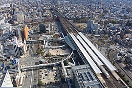
The main hub is the Nagoya train station . The railway companies Nagoya Tetsudō (Meitetsu) and Kinki Nippon Tetsudō (Kintetsu) have their own underground terminal stations in the immediate vicinity. In the northern part of the Nōbi plain, the Tōkaidō main line crosses several rivers, including the Shōnai , the Kiso and the Ibi . The Meitetsu Nagoya main line also runs in the immediate vicinity in this area. In Gifu , the route turns west and now follows the course of the historic Nakasendō Street. After bridging the Nagara and crossing the city of Ōgaki , the route at Sekigahara runs through a cut in the Ibuki Mountains.
The slope between Ōgaki and Sekigahara is up to 25 ‰. In the steam locomotive era, this was a hindrance, especially for freight traffic, because additional push locomotives had to be attached in Ōgaki . In order to increase transport capacities during the Pacific War , a 10 km long bypass was built in 1944. It is single-track, nowhere steeper than 10 ‰ and is only used by trains traveling westwards. West of Sekigahara, the Tōkaidō main line originally led to Nagahama on the east bank of Lake Biwa , where there was a connection to a steamboat line to Ōtsu . The current route has existed since 1899; it runs through the Imasu tunnel, past the highest point of the Tōkaidō main line at 179 m TP , over the border to Shiga prefecture and through the Amano valley to Maibara . This is where JR West's area of responsibility begins .
Trains
In the densely populated corridor between Toyohashi and Gifu , the Tōkaidō main line and the Meitetsu Nagoya main line of the Nagoya Tetsudō railway company run either parallel or just a few kilometers apart. Due to the fierce competition, JR Central uses numerous express trains.
There are two supraregional express trains with several connections daily, which in addition to the Tōkaidō main line also operate the Hokuriku main line and the Takayama main line. These are the Shirasagi ( し ら さ ぎ ) from Nagoya via Gifu , Maibara and Fukui to Kanazawa and the Hida ( ひ だ ) on the route ( Osaka -) Nagoya - Gifu - Takayama - Toyama . The Home Liner ( ホ ー ム ラ イ ナ ー ), express trains with reserved seats during peak traffic times, connect Nagoya with Ōgaki . However, since the timetable change in March 2013, no such trains have been offered between Nagoya and Toyohashi. The night trains Sunrise Izumo ( サ ン ラ イ ズ 出 雲 ) and Sunrise Seto ( サ ン ラ イ ズ 瀬 戸 ) also operate the Tōkaidō main line .
Four different express trains carry the bulk of the regional express traffic. Their names are “Special Rapid” ( 特別 快速 , Tokubetsu kaisoku ), “Limited Express” ( 新 快速 , Shin kaisoku ), “Rapid” ( 快速 , Kaisoku ) and “Section Fast” ( 区間 快速 , Kukan kaisoku ). What they all have in common is that they only stop at certain stations between Toyohashi and Gifu, but the number of stops varies; between Gifu and Maibara, however, they stop at all train stations. There are also regional trains with stops at all train stations between Gifu and Toyohashi, with some being linked to Hamamatsu . The rail freight by JR Freight handled.
photos

Platform in Nagoya Station

Class 313-5000 multiple unit in Nagoya
View of Gifu train station

Bridge over the Nagara


Chronology of important events
- May 1, 1883: Opening of the Nagahama - Sekigahara line (in Nagahama connection to the steamboat connection on Lake Biwa to Ōtsu )
- May 25, 1884: The Sekigahara - Ōgaki line opens
- 1st Mar 1886: Opening of the Ōbu - Atsuta line (together with today's Taketoyo line )
- Apr. 1, 1886: The Atsuta - Nagoya - Kiyosu line opens
- May 1, 1886: The Kiyosu - Owari-Ichinomiya line opens
- June 1, 1886: The Owari-Ichinomiya - Kisogawa line opens
- Jan. 21, 1887: The Ōgaki - Gifu line opens
- Apr. 25, 1887: The Kisogawa - Gifu line opens
- Sep 1 1888: The Ōbu - Toyohashi (- Hamamatsu ) line opens
- July 1, 1889: Opening of the (Sekigahara -) Fukaya - Maibara line and thus completion of the Tokyo - Kobe connection ; Closure of the Fukaya - Nagahama section
- Jan. 12, 1891: Reopening of the Fukaya - Nagahama section for freight traffic
- April 1, 1895: Introduction of the route designation Tōkaidō Line (Tōkaidō-sen)
- Nov. 1896: Closure of the Nagahama - Fukaya freight branch
- July 13, 1899: second track between Atsuta and Nagoya
- Oct. 15, 1899: Opening of the direct connection between Sekigahara and Ōmi-Nagaoka (through the Imasu tunnel)
- Dec. 28, 1899: Closure of the Sekigahara - Fukaya - Nagmi-Nagaoka section
- 23 Aug 1901: second track between Ōgaki and Tarui
- Dec 28, 1901: second track between Sekigahara and Ōmi-Nagaoka
- Feb 10, 1902: second track between Tarui and Sekigahara
- Nov. 1, 1902: second track between Ōmi-Nagaoka and Maibara
- December 20, 1903: second track between Gifu and the Nagara signal station
- 1st Mar 1907: second track between Kiyosu and the Kisogawa signal station
- 27 Mar 1907: second track between Nagoya and Biwajima
- April 8, 1907: second track between Biwajima and Kiyosu
- 26 Sep 1907: second track between Ōbu and Ōdaka
- June 13, 1907: second track between Ōdaka and Atsuta
- 28 Mar 1908: second track between Anjō and Kariya
- Apr. 29, 1908: second track between Hozumi and Ōgaki
- June 2, 1908: second track between Toyohashi and Gamagōri
- June 29, 1908: second track between Okazaki and Gamagōri
- July 29, 1908: second track between Okazaki and Anjō
- June 15, 1909: second track between the signal station Kisogawa and Gifu and between the signal station Nagara and Hozumi
- October 12, 1909: Introduction of the route name Tōkaidō Main Line (Tōkaidō-honsen)
- Feb. 1, 1913: second track between Kisogawa and the Kisogawa signal station
- Aug. 1, 1913: two-lane expansion of the entire Tōkaidō main line completed
- Feb. 1, 1937: Relocation of the line near Nagoya to a viaduct
- Oct. 11, 1944: Opening of the alternative route from Ōgaki via Shin-Tarui to Sekigahara
- July 21, 1953: Electrification of the route between Nagoya and Toyohashi (or further to Hamamatsu)
- Nov 11, 1953: Electrification of the route between Nagoya and Inazawa
- July 20, 1955: Electrification of the line between Inazawa and Maibara (including an alternative route via Shin-Tarui)
- April 1, 1987: Privatization of the Japanese State Railways and transfer of the Toyohashi - Nagoya - Maibara section of the Tōkaidō main line to the newly founded JR Central
List of train stations
Kk = Kukan-kaisoku (Rapid Section); Ka = Kaisoku (Rapid); Sk = Shin-kaisoku (Rapid Express); Tk = Tokobetsu-kaisoku (Special Rapid); HL = Home Liner
● = all trains stop at this station; ○ = individual trains stop at this station
| Surname | km | Kk | Ka | Sk | Tk | HL | Connecting lines | location | place | prefecture | |
|---|---|---|---|---|---|---|---|---|---|---|---|
| CA42 | Toyohashi ( 豊 橋 ) | 293.6 | ● | ● | ● | ● |
Tōkaidō Shinkansen Tōkaidō Main Line (Atami – Toyohashi) Iida Line Meitetsu Nagoya Main Line Toyohashi Tram at Shin-Toyohashi Station : Atsumi Line |
Coord. | Toyohashi | Aichi | |
| CA43 | Nishi-Kozakai ( 西 小 坂 井 ) | 298.4 | ● | ǀ | ǀ | ǀ | Coord. | Toyokawa | |||
| CA44 | Aichi-Mito ( 愛 知 御 津 ) | 302.1 | ● | ǀ | ǀ | ǀ | Coord. | ||||
| CA45 | Mikawa-Ōtsuka ( 三河 大 塚 ) | 305.2 | ● | ǀ | ○ | ǀ | Coord. | Gamagōri | |||
| CA46 | Mikawa-Miya ( 三河 三 谷 ) | 308.3 | ● | ○ | ○ | ǀ | Coord. | ||||
| CA47 | Gamagōri ( 蒲 郡 ) | 310.6 | ● | ● | ● | ● | Meitetsu Gamagōri Line | Coord. | |||
| CA48 | Mikawa-Shiotsu ( 三河 塩 津 ) | 312.9 | ● | ǀ | ǀ | ǀ |
at Gamagōri-Kyōteijō-mae station: Meitetsu Gamagōri line |
Coord. | |||
| CA49 | Sangane ( 三 ケ 根 ) | 315.5 | ● | ǀ | ǀ | ǀ | Coord. | Kōta | |||
| APPROX. 50 | Kōda ( 幸 田 ) | 318.5 | ● | ○ | ○ | ○ | Coord. | ||||
| CA51 | Aimi ( 相見 ) | 321.6 | ● | ǀ | ǀ | ǀ | Coord. | ||||
| CA52 | Okazaki ( 岡 崎 ) | 325.9 | ● | ● | ● | ● | Aichi ring line | Coord. | Okazaki | ||
| CA53 | Nishi-Okazaki ( 西岡 崎 ) | 330.1 | ǀ | ǀ | ǀ | ǀ | Coord. | ||||
| CA54 | Anjō ( 安 城 ) | 333.7 | ● | ● | ● | ● | Coord. | Anjō | |||
| CA55 | Mikawa-Anjō ( 三河 安 城 ) | 336.3 | ǀ | ǀ | ǀ | ǀ | Tōkaidō Shinkansen | Coord. | |||
| CA56 | Higashi-Kariya ( 東 刈 谷 ) | 338.1 | ǀ | ǀ | ǀ | ǀ | Coord. | Kariya | |||
| CA57 | Noda-Shinmachi ( 野 田 新 町 ) | 339.7 | ǀ | ǀ | ǀ | ǀ | Coord. | ||||
| CA58 | Kariya ( 刈 谷 ) | 341.6 | ● | ● | ● | ● | Meitetsu Mikawa line | Coord. | |||
| CA59 | Aizuma ( 逢 妻 ) | 343.5 | ǀ | ǀ | ǀ | ǀ | Coord. | ||||
| CA60 | Ōbu ( 大 府 ) | 346.5 | ● | ● | ● | ǀ | Taketoyo line | Coord. | Ōbu | ||
| CA61 | Kyōwa ( 共和 ) | 349.5 | ● | ● | ǀ | ǀ | Coord. | ||||
| CA62 | Minami-Ōdaka ( 南大 高 ) | 351.8 | ǀ | ǀ | ǀ | ǀ | Coord. | Nagoya | |||
| CA63 | Ōdaka ( 大 高 ) | 353.6 | ǀ | ǀ | ǀ | ǀ | Coord. | ||||
| CA64 | Kasadera ( 笠 寺 ) | 356.8 | ǀ | ǀ | ǀ | ǀ | Coord. | ||||
| CA65 | Atsuta ( 熱 田 ) | 360.8 | ǀ | ǀ | ǀ | ǀ | Coord. | ||||
| CA66 | Kanayama ( 金山 ) | 361.7 | ● | ● | ● | ● |
Chūō Main Line Meitetsu Nagoya Main Line Nagoya Subway : Meijō Line , Meikō Line |
Coord. | |||
| CA67 | Otōbashi ( 尾 頭 橋 ) | 363.6 | ǀ | ǀ | ǀ | ǀ | Coord. | ||||
| CA68 | Nagoya ( 名古屋 ) | 366.0 | ● | ● | ● | ● | ● |
Tōkaidō Shinkansen Chūō Main Line Kansai Main Line Aonami Line Nagoya Subway : Higashiyama Line Sakuradōri Line at Kintetsu-Nagoya Station : Kintetsu Nagoya Line at Meitetsu Nagoya Station : Meitetsu Nagoya Main Line |
Coord. | ||
| CA69 | Biwajima ( 枇杷 島 ) | 370.0 | ǀ | ǀ | ǀ | ǀ | ǀ | Jōhoku line | Coord. | Kiyosu | |
| CA70 | Kiyosu ( 清 洲 ) | 373.8 | ǀ | ǀ | ǀ | ǀ | ǀ | Coord. | Inazawa | ||
| CA71 | Inazawa ( 稲 沢 ) | 377.1 | ǀ | ○ | ǀ | ǀ | ǀ | Coord. | |||
| CA72 | Owari-Ichinomiya ( 尾張 一 宮 ) | 383.1 | ● | ● | ● | ● | ● |
at Meitetsu Ichinomiya Station : Meitetsu Nagoya Main Line Meitetsu Bisai Line |
Coord. | Ichinomiya | |
| CA73 | Kisogawa ( 木 曽 川 ) | 388.6 | ǀ | ǀ | ǀ | ǀ | ǀ | Coord. | |||
| CA74 | Gifu ( 岐阜 ) | 396.3 | ● | ● | ● | ● | ● |
Takayama Main Line at Meitetsu Gifu Station : Meitetsu Nagoya Main Line Meitetsu Kagamihara Line |
Coord. | Gifu | Gifu |
| CA75 | Nishi-Gifu ( 西 岐阜 ) | 399.5 | ● | ● | ● | ● | ǀ | Coord. | |||
| CA76 | Hozumi ( 穂 積 ) | 400.5 | ● | ● | ● | ● | ● | Coord. | Mizuho | ||
| CA77 | Ōgaki ( 大 垣 ) | 410.0 | ● | ● | ● | ● | ● |
Mino Akasaka Line Tarumi Line Yōrō Line |
Coord. | Ōgaki | |
| CA78 | Tarui ( 垂 井 ) | 418.1 | ● | ● | ● | ● | Coord. | Tarui | |||
| CA79 | Sekigahara ( 関 ケ 原 ) | 423.8 | ● | ● | ● | ● | Coord. | Sekigahara | |||
| CA80 | Kashiwabara ( 柏 原 ) | 430.9 | ● | ● | ● | ● | Coord. | Maibara | Shiga | ||
| CA81 | Ōmi-Nagoka ( 近 江 長 岡 ) | 435.2 | ● | ● | ● | ● | Coord. | ||||
| CA82 | Samegai ( 醒 ケ 井 ) | 439.8 | ● | ● | ● | ● | Coord. | ||||
| CA83 | Maibara ( 米 原 ) | 445.9 | ● | ● | ● | ● |
Tōkaidō Shinkansen Bivouac Line Hokuriku Main Line Ōmi Main Line |
Coord. | |||
Web links
- JR Central route network (PDF, 1.2 MB)
Individual evidence
- ↑ In: Tetsudō jānaru. Volume 21, No. 1. Railway Journal Company, Chiyoda 1987, p. 120.
- ↑ 週刊 歴 史 で め ぐ る 鉄 道 全 路線 国 鉄 ・ JR 01 東海 道 本 線 . Asahi Shimbun-sha , Osaka 2009, p. 21-23 .
- ↑ a b c JR 時刻表 2016 年 3 月 号 (JR timetable March 2016). Kōtsū shinbunsha, Tokyo 2016.
- ↑ 平 成 25 年 3 月 ダ イ ヤ 改正 に つ い て. (PDF, 383 kB) JR Central , December 21, 2012, accessed July 31, 2018 (Japanese).
Current lines: Tōkaidō-Shinkansen | Chūō main line | Gotemba Line | Iida line | Jōhoku Line | Kansai main line | Kisei main line | Meishō Line | Mino Akasaka Line | Minobu Line | Sangu line | Taita line | Takayama main line | Taketoyo line | Tōkaidō main line ( Atami – Toyohashi , Toyohashi – Maibara )
Released Lines: Nishi Nagoyakō Line | Okata line