Toyokawa
| Toyokawa-shi 豊 川 市 |
||
|---|---|---|
| Geographical location in Japan | ||
|
|
||
| Region : | Chūbu | |
| Prefecture : | Aichi | |
| Coordinates : | 34 ° 50 ' N , 137 ° 23' E | |
| Basic data | ||
| Surface: | 150.71 km² | |
| Residents : | 183,823 (June 1, 2019) |
|
| Population density : | 1220 inhabitants per km² | |
| Community key : | 23207-6 | |
| Symbols | ||
| Flag / coat of arms: | ||
| Tree : | Japanese black pine | |
| Flower : | Rhododendron indicum | |
| Song : | Toyokawa-shi Uta (City Toyokawa Song) | |
| town hall | ||
| Address : |
Toyokawa City Hall 1 - 1 Suwa Toyokawa -shi Aichi 442-0068 |
|
| Website URL: | http://www.city.toyokawa.lg.jp | |
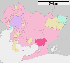
| Location of Toyokawa in Aichi Prefecture | ||
Toyokawa ( Japanese 豊 川 市 , -shi ) is a city in Aichi Prefecture on Honshū , the main island of Japan .
geography
Toyokawa is north of Toyohashi and south of Okazaki .
history
Toyokawa City was founded on June 1, 1943.
During the Second World War , the city was bombed several times by the United States Army Air Forces (USAAF) between December 1944 and July 1945 . The attack with the most serious consequences was an area bombing with napalm bombs on July 3, 1945. The attacks destroyed around 85% of the city area and claimed 1,000 deaths. (see air raids on Japan )
Attractions
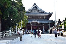
- Toyokawa Inari , Buddhist temple
- Toga Jinja , Shinto shrine
traffic
Toyokawa can be reached via the Tōmei Expressway and National Road 1 towards Tokyo or Nagoya . The city is on the JR Central- operated Iida Line and the Meitetsu Toyokawa Line , both of which serve Toyokawa Station .
Twin cities
Toyokawa has had a partnership with the American Cupertino since 1978 .


