
Nagoya
| Nagoya-shi 名古屋 市 |
|||
|---|---|---|---|
|
|||
| Geographical location in Japan | |||
| Region : | Chūbu | ||
| Prefecture : | Aichi | ||
| Coordinates : | 35 ° 11 ' N , 136 ° 54' E | ||
| Basic data | |||
| Area: | 326.45 km² | ||
| Residents : | 2,325,918 (June 1, 2019) |
||
| Population density : | 7125 inhabitants per km² | ||
| Community key : | 23100-2 | ||
| Postal code area : | 460-0002 - 468-0836 | ||
| Symbols | |||
| Flag / coat of arms: |
 |
||
| Tree : | Camphor tree | ||
| Flower : | Lilies | ||
| Song : | Waga Nagoya (Our Nagoya) | ||
| town hall | |||
| Address : |
Nagoya City Hall 3 - 1 - 1 , Sannomaru Naka-ku , Nagoya -shi Aichi 460-0001 |
||
| Website URL: | http://www.city.nagoya.jp/ | ||
| Location of Nagoya in Aichi Prefecture | |||
 |
|||

Nagoya ( Japanese 名古屋 市, - shi ) is a city, port and administrative seat of the Japanese prefecture of Aichi on Honshū on the Pacific ( Japan ).
With 2.3 million inhabitants, Nagoya is the fourth largest industrial center in Japan after Tokyo , Yokohama and Osaka and is mainly known for the baseball club Chūnichi Dragons and the soccer club Nagoya Grampus Eight .
geography
Nagoya extends north of Ise Bay over the central part of the extensive and fertile Nōbi plain . The highest point is therefore the 198.3 m high hill Tōgoku-san (東 谷 山) in the extreme northeast of the city on the border with Seto .
The city's most important river is the Shōnai-gawa 1st order river with its many tributaries, as well as the 2nd order Tempaku-gawa (天 白 川) and Nikkō-gawa (日光 川) river systems.
The metropolitan region of Nagoya (名古屋 圏, ~ -ken ) or Chūkyō (中 京 [圏] , ~ -ken , dt. About: "[region] between the capitals" in reference to Tokyo and the former capital of Japan Kyōto ), which extends around the entire Ise Bay and thus also into the prefectures of Gifu and Mie, covers 7072 km² with 9.1 million inhabitants (2015) and is the third largest in Japan after the metropolitan regions Tokyo-Yokohama and Kyoto-Osaka-Kobe .
City structure
Nagoya is divided into 16 boroughs ( - ku )

|
Code with check digit |
Surname | Area (in km²) | population | Population density (inh / km²) |
||
|---|---|---|---|---|---|---|
| Rōmaji , | Kanji | 1.10.2017 1 | 1.10.2018 2 | October 1, 2015 3 | ||
| 23101-1 | Chikusa-ku | 千種 区 | 18.18 | 166.070 | 164,696 | 9059.19 |
| 23102-9 | Higashi-ku | 東区 | 7.71 | 80,568 | 78.043 | 10122.31 |
| 23103-7 | Kita-ku | 北区 | 17.53 | 163.712 | 163,579 | 9331.37 |
| 23104-5 | Nishi-ku | 西区 | 17.93 | 149,830 | 149,098 | 8315.56 |
| 23105-3 | Nakamura-ku | 中 村 区 | 16.30 | 135.075 | 133.206 | 8172.15 |
| 23106-1 | Naka-ku | 中 区 | 9.38 | 88,856 | 83.203 | 8870.26 |
| 23107-0 | Showa-ku | 昭和 区 | 10.94 | 109,596 | 107.170 | 9796.16 |
| 23108-8 | Mizuho-ku | 瑞 穂 区 | 11.22 | 107.197 | 105.357 | 9390.11 |
| 23109-6 | Atsuta-ku | 熱 田 区 | 8.20 | 66,162 | 65,895 | 8035.98 |
| 23110-0 | Nakagawa-ku | 中 川 区 | 32.02 | 220,660 | 220.281 | 6879.48 |
| 23111-8 | Minato-ku | 港区 | 45.64 | 144.198 | 146.745 | 3215.27 |
| 23112-6 | Minami-ku | 南 区 | 18.46 | 136,451 | 136.935 | 7417.93 |
| 23113-4 | Moriyama-ku | 守 山区 | 34.01 | 175.471 | 172.845 | 5082.18 |
| 23114-2 | Midori-ku | 緑 区 | 37.91 | 246.273 | 241,822 | 6378.84 |
| 23115-1 | Meito-ku | 名 東区 | 19.45 | 165,589 | 164.080 | 8435.99 |
| 23116-9 | Tempaku-ku | 天 白区 | 21.58 | 164,653 | 162,683 | 7538.6 |
| 23100-2 | Nagoya-shi | 名古屋 市 | 326.45 | 2,320,361 | 2,295,638 | 7032.13 |
history
Surname
The characters used to spell the place name can literally be read as "well-known, old house". However, these are Ateji , i.e. H. they were chosen mainly because of their pronunciation, in order to write a pre-existing identical term, the meaning of which is no longer known today.
The oldest evidence of the place name in the late Heian period is the fiefdom ( shōen ) Nagoya-shō (那 古 野 荘), which was owned by Taira no Shigeko ( Kenshū-mon'in ; 1142–1176), a woman des Tennōs Go-Shirakawa and mother of Tennō Takakura .
Later, instead of the character野'field, grassland', the homonymous屋'house' was used to denote the manor house. Alternative spellings in addition to this那 古屋were also名 護 屋and名古屋, the latter later prevailing. This mansion was located in what is now the Nagono district of the Nishi-ku district. To distinguish那 古Aussprache, the pronunciation of that nagono was used, in which the last character in the Japanese reading no instead of the other two in the Sino-Japanese reading ya was spoken. The earlier pronunciation for this spelling can still be found in the name of the Nagoya shrine (那 古 野 神社, Nagoya-jinja ).
After the construction of Nagoya Castle , the surrounding castle town ( jōkamachi ) was also given this name, while the village of Nagono continued to exist independently to the southwest until it was incorporated in August 1898.
A historical name for Nagoya was also Hōsa (蓬 左), which means "left of the Atsuta shrine ", which was also equated with the mythological island of Hōrai .
middle age

The city was known as the trading center and capital of the Owari province as early as the Middle Ages . Oda Nobunaga was born in 1534 in Nagono Castle, the predecessor of Nagoya Castle. In 1555 he moved to Kiyosu Castle , shifting the center of power in central Japan to Kiyosu. In 1610, Nagoya Castle was rebuilt by Tokugawa Ieyasu . Nagoya then became the clear center of Owari again. After the Tokugawa family had secured their power as Shogun , the first Shogun Tokugawa Ieyasu gave the city of Nagoya to his 7th son.
Modern
Only a few of the historical buildings survived the war. Most were in the Second World War in the air raids on Nagoya, especially on 14./17. May 1945 completely destroyed. The castle was partially rebuilt in 1959, the castle tower is famous for its two approximately 2 m high gold-plated shachi (鯱) on the gable ends. The cultural treasure of the Owari branch of the Tokugawa family is exhibited today at the Tokugawa Private Art Museum. This important art collection from all cultural epochs contains a number of national treasures .
On September 26, 1959, the southern part of the city was devastated by the Ise-wan typhoon .
Incorporations
On 20 December 1878, the city to the administrative unit was Nagoya ku (名古屋区), the April 1, 1889, the introduction of modern Japanese community structures to today's Nagoya-shi was. At that time the area of the municipality was 13.34 km². The first area enlargement took place on March 23, 1896 with parts (0.80 km²) of the village ( mura ) Gokizō (御 器 所 村). On August 22, 1898, the village of Nagono (那 古 野村) and parts of Furusawa (古 沢 村) were incorporated (both together 2.15 km²), and on June 1, 1907 the district town ( chō ) Atsuta (熱 田 町; 1, 25 km²), which at that time also received the remaining parts of Furusawa. One month later, on July 16, parts (14.39 km²) of Ousu (小 碓 町) followed, and on October 1, 1909, parts of Gokizō and Chikusa (千種 町), both 1.27 km², followed. On August 22, 1921, a wave of incorporation took place in which more than half of the communities in Aichi County , as well as several from Nishikasugai County, were completely incorporated. These goods
- Arako (荒 子 村),
- Tokiwa (常 盤 村),
- Nakamura (中 村),
- Aichi (愛 知 町),
- Yahata (八 幡 村),
- Yobitsugi (呼 続 町),
- Kasadera (笠 寺村; already parts of it on February 20),
- Ousu,
- Gokizō,
- Chikusa,
- Higashiyama (東 山村),
- Rokugō (六 郷 村),
- Shimizu (清水 町),
- Sugimura (杉 村),
- Kinjō (金城 村) and
- Biwajima (枇杷 島 町).
The urban area grew more than threefold from 38.26 to 149.56 km². On March 3, 1928, the district Yagoto (八 事; 0.01 km²) from Tempaku (天 白 村) was added, on June 15, 1930 parts (0.01 km²) of Shōnai (庄内 町) and on July 15, 1931 parts (<0.01 km²) from Shimonoisshiki (下 之一 色 町). The rest of the latter two then followed together with Hogino (萩 野村) on March 1, 1937, a total of 8.84 km². During the war there were no further incorporations, which only began again in 1950 - on April 5, Itaka (猪 高 村) and the remaining Tempaku (both together 43.71 km²), and on October 1, Kusunoki (楠 村), Yamada (山 田村), Tomita (富田 町) and Nan'yō (南陽 町) - all four together 42.09 km². 1963 followed on February 15, the independent city of Moriyama (守 山 市; 34.01 km²) and on April 1st Narumi (鳴 海 町; 26.30 km²). The last incorporation took place on December 1, 1964 with Ōdaka (大 高 町) and Arimatsu (有 松 町) - both together 11.39 km².
Politics and administration

Mayor of Nagoya has been Takashi Kawamura since April 2009 , who was confirmed in office in a “return election ” in February 2011 and the regular elections in April 2013 and April 2017. Kawamura, a former member of the national parliament for the Democratic Party , founded his own party, Genzei Nippon (“Japan Tax Cut”) in 2010 to push through his tax cut plans, which had previously been rejected in the city council by both major parties.
The city council ( Nagoya-shikai ) was re-elected in the unified regional elections in April 2019 and reduced to 68 seats. The Liberal Democratic Party remained the strongest force, the Genzei Nippon rose again, the Communist Party of Japan lost significantly.
The municipal districts of Nagoya elect a total of 31 members of the Aichi prefectural parliament, which has 102 members. 11 districts are two-mandate constituencies in which a division of seats between the two strongest camps is likely. According to the prefecture election 2019 provide Lib Dem and Shinsei Aichi (Joint fraction of DVP , KDP , Rengo ready or almost ready MPs Independent) a majority of the MPs. There are also two Kōmeitō MPs and one from Genzei Nippon from the city of Nagoya .
The city of Nagoya extends into five constituencies ( Aichi 1 to 5 ) for the national lower house , one of which also includes some suburbs. In the 2017 general election , all five incumbent MPs were re-elected: In constituencies 1 and 4, the Liberal Democrats Hiromichi Kumada and Shōzō Kudō and the former democrats Motohisa Furukawa (Aichi 2, Party of Hope ; now DVP), Shōichi Kondō (Aichi 3, constitutional Democratic Party ) and Hirotaka Akamatsu (Aichi 5, Constitutional Democratic Party).
Tourist Attractions

- Nagoya Castle - originally built from 1609 to 1612, burned down almost completely during World War II and was partially rebuilt in 1959.
- Nagoya TV tower
- Atsuta Shrine - known as the second most important imperial shrine in Japan. In addition to more than 4,000 archaeological and historical objects on the history of the country, it probably houses the Kusanagi no mitsurugi (草 薙 神 剣, German "divine sword Kusanagi"), one of the three imperial regalia .
- Tokugawa Art Museum
- Shirotori Park
- Higashiyama Park and Zoo
- Nagoya Port
- Aichi Prefectural Museum of Art with Japanese and foreign art from the 20th century
- Nagoya City Art Museum
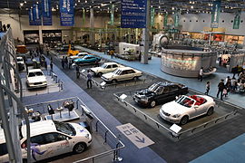
- Railway Museum (リ ニ ア ・ 鉄 道 館, English SCMAGLEV and Railway Park )

Hommaru Palace (Nagoya Castle)
Toyota Memorial Museum of Industry and Technology

Railway Museum
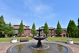
Noritake garden

Arimatsu
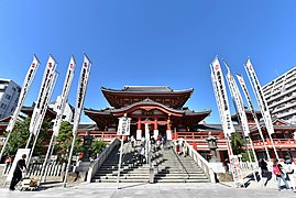
Ōsu Kannon
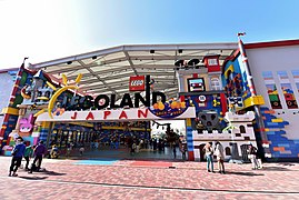
Legoland Japan Resort


economy
According to a study from 2014, the Nagoya metropolitan area has a gross domestic product of 364 billion US dollars (KKB). In the ranking of the world's economically strongest metropolitan regions, it was ranked 22nd and third in Japan behind Tokyo and the Osaka-Kobe region.
The most important branches of industry are the automotive and mechanical engineering industries. The large company Toyota resides in the nearby city of the same name Toyota . Other manufacturers such as the Toyota subsidiary Lexus and suppliers such as Denso , Aisin Seiki and the original ceramic company NGK Spark Plug, which has now specialized in spark plugs, and its offshoot NGK Insulators also reside in the greater Nagoya area. Another world-renowned company from Nagoya is Brother Industries , which is known primarily for printers and fax machines . A more recent establishment in Nagoya is the Mitsubishi Aircraft Corporation .
traffic
Nagoya has a subway network consisting of 6 lines . The two largest railway companies are JR Central and Nagoya Tetsudō (Meitetsu), also important is Kinki Nippon Tetsudō (Kintetsu). The central railway junction is Nagoya station with the JR Central Towers, it is considered to be the tallest station building in the world.
As the center of the auto industry, Nagoya has very well developed roads by Japanese standards, and the share of private cars in total traffic is correspondingly high (approx. 70% compared to 30–50% in other Japanese metropolises). The area of the city is surrounded by the Nagoya highway network .
On February 17, 2005, the new Central Japan International Airport , called Centrair , opened on an artificial island in the sea off the city of Tokoname , largely replacing the old Nagoya Airport . The airport was built for the 2005 Expo . Nagoya is served daily by Lufthansa from Frankfurt am Main , among others .
education
Nagoya is home to Nagoya University and Nagoya Municipal University . There is also the private Nanzan University , which was founded by the Steyler missionaries and which has gained greater prominence through the Center for Japanese Studies (CJS).
Sports
Nagoya is home to the Nagoya Grampus Eight football club from the J. League , whose games are played at the Paloma Mizuho Stadium .
Nagoya is home to the Chūnichi Dragons baseball club , whose games are played in the Nagoya Dome .
Nagoya is also the venue for the Nagoya Women's Marathon .
Personalities
Twin cities
-
 Los Angeles , USA (since 1959)
 -
 Mexico City , Mexico (since 1978)
 -
 Nanjing , People's Republic of China (since 1978)
 -
 Sydney , Australia (since 1980)
 -
 Turin , Italy (since 2005)
Neighboring cities and towns
- Kasugai
- Seto
- Kiyosu
- Tōkai
- Nisshin
- Owariasahi
- Toyoake
- Kitanagoya
- Ama
- Ōbu
- Toyoyama
- Ōharu
- Nagakute
- Tōgō
- Tobishima
- Kanie
Nagoya Protocol
The Nagoya Protocol is an international environmental agreement adopted in Nagoya on October 29, 2010 to implement the goals of the UN Convention on Biological Diversity , which came into force on October 12, 2014. It regulates access to genetic resources and fair sharing of benefits .
Climate table
| Nagoya | ||||||||||||||||||||||||||||||||||||||||||||||||
|---|---|---|---|---|---|---|---|---|---|---|---|---|---|---|---|---|---|---|---|---|---|---|---|---|---|---|---|---|---|---|---|---|---|---|---|---|---|---|---|---|---|---|---|---|---|---|---|---|
| Climate diagram | ||||||||||||||||||||||||||||||||||||||||||||||||
| ||||||||||||||||||||||||||||||||||||||||||||||||
|
Average monthly temperatures and rainfall for Nagoya
Source: Japan Meteorological Agency ; wetterkontor.de
|
|||||||||||||||||||||||||||||||||||||||||||||||||||||||||||||||||||||||||||||||||||||||||||||||||||||||||||||||||||||||||||||||||||||||||||||||||||||||||||||||||||||
Web links
- Nagoya Information Navi
- Official website (multilingual)
- Nagoya International Center (multilingual)
Individual evidence
- ↑ 名古屋 市 水 防 計画. (PDF) Nagoya, 2014, p. 4 , accessed August 18, 2016 (Japanese).
- ↑ 中 京. In: Daijirin at kotobank.jp. Retrieved August 26, 2015 (Japanese).
- ↑ Statistical Handbook of Japan 2015. 6. Population Density and Regional Distribution. Japanese Statistical Office, accessed July 15, 2016 .
- ↑ a b 名古屋 市 歴 史 的 風 致 維持 向上 計画(Development Plan to Maintain the Historical Charm of the City of Nagoya). (PDF, 3.0 MB) Nagoya, 2016, p. 16 , accessed on August 18, 2016 (Japanese).
- ↑ 市 営 住宅 一 覧 (北区 ・ 西区 ・ 中 村 区) . Nagoya, April 1, 2015, accessed August 26, 2015 (Japanese).
- ↑ な ご や カ レ ン ダ ー 8 月. Nagoya City Library, accessed August 26, 2015 (Japanese).
- ↑ 蓬 左. In: Daijirin at kotobank.jp. Retrieved August 26, 2015 (Japanese).
- ↑ 4 地理 的 ・ 歴 史 的 つ な が り. (PDF) (No longer available online.) Nagoya City, p. 208 , archived from the original on August 18, 2016 ; Retrieved on August 18, 2016 (Japanese, The source leads to the Kawanaka and Hogino in April Shōwa 8 (1933) was incorporated into Nagoya. In fact, at this time Kawanaka was incorporated into Hogino and the latter Shōwa 12 (1937) to Nagoya.). Info: The archive link was inserted automatically and has not yet been checked. Please check the original and archive link according to the instructions and then remove this notice.
- ↑ 1-1-1 市 域 の 変 遷 (I) (明治 22 年 ~ 昭和 18 年) . ( MS Excel ; 26 kB) City of Nagoya, accessed on May 6, 2012 (Japanese).
- ↑ 1-1-2 市 域 の 変 遷 (II) (昭和 25 年 ~ 昭和 58 年) . ( MS Excel ; 22 kB) City of Nagoya, accessed on May 6, 2012 (Japanese).
- ↑ Nagoya City Council : MPs by Group (Japanese), accessed September 25, 2020.
- ^ Tax-cutting Mayor Kawamura re-elected in Nagoya. In: The Japan Times . April 22, 2013, accessed April 22, 2013 .
- ↑ 名古屋 市長 選 、 現 職 ・ 河村 氏 が 4 選. In: nikkei.com . April 23, 2017. Retrieved April 23, 2017 (Japanese).
- ↑ 名古屋 市 議 選 各 党 議席. In: NHK Senkyo Web. April 8, 2019, Retrieved May 20, 2019 (Japanese).
- ↑ Aichi Prefectural Parliament : Members by constituency , accessed on May 21, 2019.
- ^ Alan Berube, Jesus Leal Trujillo, Tao Ran, and Joseph Parilla: Global Metro Monitor . In: Brookings . January 22, 2015 ( brookings.edu [accessed July 19, 2018]).
Independent cities ( shi ): Aisai | Ama | Anjō | Chiryu | Chita | Gamagōri | Handa | Hekinan | Ichinomiya | Inazawa | Inuyama | Iwakura | Kariya | Kasugai | Kitanagoya | Kiyosu | Komaki | Kōnan | Miyoshi | Nagakute | Nagoya (administrative headquarters) | Nishio | Nisshin | Okazaki | Ōbu | Owariasahi | Seto | Shinshiro | Tahara | Takahama | Tokoname | Tōkai | Toyoake | Toyohashi | Toyokawa | Toyota | Tsushima | Yatomi
Aichi-gun : Tōgō | Ama-gun : Kanie | Ōharu | Tobishima | Chita-gun : Agui | Higashiura | Mihama | Minamichita | Taketoyo | Kitashitara-gun : Shitara | Tōei | Toyone | Nishikasugai-gun : Toyoyama | Niwa-gun : Fusō | Ōguchi | Nukata-gun : Kōta