
Nagakute
| Nagakute-shi 長久 手 市 |
|||
|---|---|---|---|
 |
|||
| Geographical location in Japan | |||
|
|||
| Region : | Chūbu | ||
| Prefecture : | Aichi | ||
| Coordinates : | 35 ° 11 ' N , 137 ° 3' E | ||
| Basic data | |||
| Surface: | 21.54 km² | ||
| Residents : | 61,325 (June 1, 2019) |
||
| Population density : | 2847 inhabitants per km² | ||
| Community key : | 23238-6 | ||
| Symbols | |||
| Flag / coat of arms: |
 |
||
| Tree : | maple | ||
| Flower : | Rhododendron indicum | ||
| town hall | |||
| Address : |
Nagakute City Hall 60 - 1 , Yazako-Shironouchi Nagakute -shi Aichi 480-1196 |
||
| Website URL: | www.city.nagakute.lg.jp | ||
| Location Nagakutes in Aichi Prefecture | |||
 |
|||

Nagakute ( Japanese 長久 手 市 , - shi ) is a Japanese city in Aichi Prefecture .
geography
Nagakute is located in the east of the Nōbi plain and is traversed by the Kanare-gawa ( 香 流川 ).
The neighboring communities are:
| Owariasahi | Seto | |
| Nagoya |
.svg)
|
Toyota |
| Nisshin | Nisshin | Nisshin |
history
In 1584 the Battle of Komaki and Nagakute took place here between the armies of Toyotomi Hideyoshi and Tokugawa Ieyasu .
The community Nagakute emerged on May 10, 1906 from the union of the villages Nagakute ( 長 湫 村 , - mura ), Kamigō ( 上 郷 村 , -mura ) and Yazako ( 岩 作 村 , -mura ) in the district of Aichi . The new name was taken over from the former municipality, but in the changed spelling 長久 手 村 . On April 1, 1971, it was upgraded to a municipality ( chō ).
On January 4, 2012, Nagakute was appointed a district-free city ( shi ), whereby Tōgō is now the only municipality in Aichi County.
traffic
Nagakute is not directly connected to any major trunk road (national road or motorway). However, the Tōmei motorway to Setagaya , Tokyo or Komaki leads through the municipality, but without a junction . The Nagoya junction is located directly on the outskirts and is connected via Prefecture Road 60.
Nagakute is also not connected to the national rail network. In the course of the Expo 2005 , however, the Linimo magnetic levitation train was built, with which the neighboring cities of Nagoya and Toyota can be reached.
Attractions
Nagakute was the main venue for the World Expo 2005 . The 194.2 hectare site, Ai Chikyū-Haku Kinenbi Kōen ( 愛 ・ 地球 博 記念 公園 ), can still be visited in part.
The museums in Nagakute include the Toyota Museum ( ト ヨ タ 博物館 , Toyota Hakubutsukan ) on the automotive history of Toyota , but also other vehicle manufacturers, as well as the Meito Art Museum ( 名 都 美術館 , Meito Bijutsukan ) with works by Japanese artists such as Itō Shinsui , Uemura Shōen and Kaburagi Kiyokata .
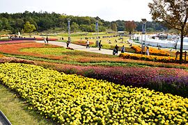
Ai Chikyū-Haku Kinenbi Kōen

Toyota Museum
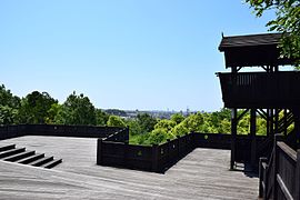
Iroganeyama Historical Park


education
The primary schools ( 長久 手 市立 X 小学校 , Nagakute-shiritsu X shōgakkō ) Nagakute, Nishi ( 西 , “West”), Higashi ( 東 , “East”), Kita ( 北 , “North”), Minami ( 南 , "South") and Ichigahora ( 市が洞 ), the middle schools ( 長久手市立X中学校 , Nagakute-Shiritsu X chūgakkō ) Nagakute and Minami, as well as the public high school Nagakute ( 愛知県立長久手高等学校 , Aichi-kenritsu Nagekute Kōtō gakko ) and the private Eitoku high school ( 栄 徳 高等学校 , Eitoku kōtō gakkō ).
Are in Nagekute in higher education, the Medical School Aichi ( 愛知医科大学 , Aichi Ika Daigaku ), the School of Art Aichi ( 愛知県立芸術大学 , Aichi kenritsu Geijutsu Daigaku ), the Aichi Shuntoku University ( 愛知淑徳大学 , Aichi Shuntoku Daigaku ) and Aichi Prefectural University ( 愛 知 県 立 大学 , Aichi-kenritsu Daigaku ).
Town twinning
Since 1992, the Belgian Waterloo has been Nagakute's sister city.
An exchange agreement was concluded with Nagiso in Germany on October 21, 2006.
Personalities
- Shumpei Fukahori (* 1998), soccer player
Web links
Independent cities ( shi ): Aisai | Ama | Anjō | Chiryu | Chita | Gamagōri | Handa | Hekinan | Ichinomiya | Inazawa | Inuyama | Iwakura | Kariya | Kasugai | Kitanagoya | Kiyosu | Komaki | Kōnan | Miyoshi | Nagakute | Nagoya (administrative headquarters) | Nishio | Nisshin | Okazaki | Ōbu | Owariasahi | Seto | Shinshiro | Tahara | Takahama | Tokoname | Tōkai | Toyoake | Toyohashi | Toyokawa | Toyota | Tsushima | Yatomi
Aichi-gun : Tōgō | Ama-gun : Kanie | Ōharu | Tobishima | Chita-gun : Agui | Higashiura | Mihama | Minamichita | Taketoyo | Kitashitara-gun : Shitara | Tōei | Toyone | Nishikasugai-gun : Toyoyama | Niwa-gun : Fusō | Ōguchi | Nukata-gun : Kōta