Ichinomiya (Aichi)
| Ichinomiya-shi 一 宮 市 |
||
|---|---|---|
| Geographical location in Japan | ||
|
|
||
| Region : | Chūbu | |
| Prefecture : | Aichi | |
| Coordinates : | 35 ° 18 ' N , 136 ° 48' E | |
| Basic data | ||
| Surface: | 113.91 km² | |
| Residents : | 379,689 (June 1, 2019) |
|
| Population density : | 3333 inhabitants per km² | |
| Community key : | 23203-3 | |
| Symbols | ||
| Flag / coat of arms: | ||
| Tree : | Blossom dogwood | |
| Flower : | Balloon flower | |
| town hall | ||
| Address : |
Ichinomiya City Hall 2 - 5 - 6 , Hon-machi Ichinomiya -shi Aichi 491-8501 |
|
| Website URL: | http://www.city.ichinomiya.aichi.jp | |
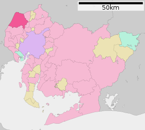
| Location of Ichinomiyas in Aichi Prefecture | ||
Ichinomiya ( Japanese 一 宮 市 , - shi ) is a Japanese city in Aichi Prefecture .
geography
Ichinomiya is northwest of Nagoya and west of Kōnan .
The Kiso River flows through the city from northeast to southwest.
history
The city was founded on September 1, 1921. On April 1, 2005, the city of Bisai ( 尾 西 市 , -shi ) and the Chō Kisogawa ( 木 曽 川 町 , -chō ) of Haguri County was incorporated.
traffic
- Street:
- Meishin Highway
- Tōkai-Hokuriku Highway
- National roads 22, 155
- Train:
- JR Tōkaidō Main Line : to Tokyo , Nagoya and Osaka
- Meitetsu Nagoya main line
- Meitetsu Bisai main line
sons and daughters of the town
- Masaaki Kanda (* 1951), governor of Aichi
- Yukiko Okada (1967-1986), singer
- Asanowaka Takehiko (* 1969), sumo wrestler
- Arina Tanemura (* 1978), Mangaka
- Tōru Tani (* 1954), philosopher
Neighboring cities and communities
- Aichi prefecture
- Gifu Prefecture
Web links
Commons : Ichinomiya - collection of pictures, videos and audio files


