Tokoname
| Tokoname-shi 常 滑 市 |
||
|---|---|---|
| Geographical location in Japan | ||
|
|
||
| Region : | Chūbu | |
| Prefecture : | Aichi | |
| Coordinates : | 34 ° 53 ' N , 136 ° 50' E | |
| Basic data | ||
| Surface: | 55.63 km² | |
| Residents : | 57,814 (June 1, 2019) |
|
| Population density : | 1039 inhabitants per km² | |
| Community key : | 23216-5 | |
| Symbols | ||
| Flag / coat of arms: | ||
| Tree : | Kuro pines | |
| Flower : | Camellia sasanqua | |
| town hall | ||
| Address : |
Tokoname City Hall 4 - 1 Shinkai-cho Tokoname -shi Aichi 479-8610 |
|
| Website URL: | http://www.city.tokoname.aichi.jp/ | |
| Location Tokonames in Aichi Prefecture | ||
Tokoname ( Japanese 常 滑 市 , - shi ) is a city in Aichi Prefecture on Honshū , the main island of Japan .
geography
Tokoname is located south of Nagoya on the Chita Peninsula on Ise Bay .
history
The city of Tokoname was founded on April 1, 1954 from the former communities of Tokoname, Nishiura (西 浦), Onizaki (鬼 崎), Miwa (三 和), Kosugaya (小 鈴 谷) and Ono (大野).
traffic
- train
- Street
- National road 155.247
economy
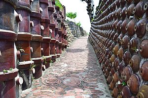
Tokoname has always been known for its ceramic industry , especially for the Japanese side-handle teapots known as kyūsu .
sons and daughters of the town
- Morita Akio (1921–1999), entrepreneur
- Emi and Yumi Itō ( The Peanuts ) (* 1941, Emi † 2012), singers
- Michiyo Yagi (* 1962), musician
Neighboring cities and communities
Web links
Commons : Tokoname - collection of images, videos and audio files
- Official website in English


