
Iida line
| Iida line | |||||||||||||||||||||||||||||||||||||||||||||||||||||||||||||||||||||||||||||||||||||||||||||||||||||||||||||||||||||||||||||||||||||||||||||||||||||||||||||||||||||||||||||||||||||||||||||||||||||||||||||||||||||||||||||||||||||||||||||||||||||||||||||||||||||||||||||||||||||||||||||||||||||||||||||||||||||||||||||||||||||||||||||||||||||||||||||||||||||||||||||||||||||||||||||||||||||||||||||||||||||||||||||||||||||||||||||||||||||||||||||||||||||||||||||||||||||||||||||||||||||||||||||||||||||||||||||||||||||||||||||||||||||||||||||||||||||||||||||||||||||||||||||||||||||||||||||||||||||||||||||||||||||||||||||||||||||||||||||||||||||||||||||||||||||||||||||||||||||||||||||||||||||||||||||||||||||||||||||||||||||||||||||||||||||||||||||||||||||||||||||||||||||||||||||||||||||||||||||||||||||||||||||||||||||||||||||||||||||||||||||||||||||||||||||||||||||||||||||||||||||||||||||||||
|---|---|---|---|---|---|---|---|---|---|---|---|---|---|---|---|---|---|---|---|---|---|---|---|---|---|---|---|---|---|---|---|---|---|---|---|---|---|---|---|---|---|---|---|---|---|---|---|---|---|---|---|---|---|---|---|---|---|---|---|---|---|---|---|---|---|---|---|---|---|---|---|---|---|---|---|---|---|---|---|---|---|---|---|---|---|---|---|---|---|---|---|---|---|---|---|---|---|---|---|---|---|---|---|---|---|---|---|---|---|---|---|---|---|---|---|---|---|---|---|---|---|---|---|---|---|---|---|---|---|---|---|---|---|---|---|---|---|---|---|---|---|---|---|---|---|---|---|---|---|---|---|---|---|---|---|---|---|---|---|---|---|---|---|---|---|---|---|---|---|---|---|---|---|---|---|---|---|---|---|---|---|---|---|---|---|---|---|---|---|---|---|---|---|---|---|---|---|---|---|---|---|---|---|---|---|---|---|---|---|---|---|---|---|---|---|---|---|---|---|---|---|---|---|---|---|---|---|---|---|---|---|---|---|---|---|---|---|---|---|---|---|---|---|---|---|---|---|---|---|---|---|---|---|---|---|---|---|---|---|---|---|---|---|---|---|---|---|---|---|---|---|---|---|---|---|---|---|---|---|---|---|---|---|---|---|---|---|---|---|---|---|---|---|---|---|---|---|---|---|---|---|---|---|---|---|---|---|---|---|---|---|---|---|---|---|---|---|---|---|---|---|---|---|---|---|---|---|---|---|---|---|---|---|---|---|---|---|---|---|---|---|---|---|---|---|---|---|---|---|---|---|---|---|---|---|---|---|---|---|---|---|---|---|---|---|---|---|---|---|---|---|---|---|---|---|---|---|---|---|---|---|---|---|---|---|---|---|---|---|---|---|---|---|---|---|---|---|---|---|---|---|---|---|---|---|---|---|---|---|---|---|---|---|---|---|---|---|---|---|---|---|---|---|---|---|---|---|---|---|---|---|---|---|---|---|---|---|---|---|---|---|---|---|---|---|---|---|---|---|---|---|---|---|---|---|---|---|---|---|---|---|---|---|---|---|---|---|---|---|---|---|---|---|---|---|---|---|---|---|---|---|---|---|---|---|---|---|---|---|---|---|---|---|---|---|---|---|---|---|---|---|---|---|---|---|---|---|---|---|---|---|---|---|---|---|---|---|---|---|---|---|---|---|---|---|---|---|---|---|---|---|---|---|---|---|---|---|---|---|---|---|---|---|---|---|---|---|---|---|---|---|---|---|---|---|---|---|---|---|---|---|---|---|---|---|---|---|---|---|---|---|---|---|---|---|---|---|---|---|---|---|---|---|---|---|---|---|---|---|---|---|---|---|---|---|---|---|---|---|---|---|---|---|---|---|---|---|---|---|---|---|---|---|---|---|---|---|---|---|---|---|---|---|---|---|---|---|---|---|---|---|---|---|---|---|---|---|---|---|---|---|---|---|---|---|---|---|---|---|---|---|---|---|---|---|---|---|---|---|---|---|---|---|---|---|---|---|---|---|---|---|---|---|---|---|---|---|---|---|---|---|---|---|---|---|---|---|---|---|---|---|---|---|---|---|---|---|---|---|---|---|---|---|---|---|---|---|---|---|---|---|---|---|---|---|---|---|---|---|---|---|---|---|---|---|---|---|---|---|---|---|---|---|---|---|---|---|---|---|---|---|---|---|---|---|---|---|---|---|---|---|---|---|---|---|---|---|---|---|---|---|---|---|---|---|---|---|---|---|---|---|---|---|---|---|---|---|---|---|---|---|---|---|---|---|---|---|---|---|---|---|---|---|---|---|---|---|---|---|---|---|---|---|---|---|---|---|---|---|---|---|---|---|---|---|---|---|---|---|---|---|---|---|---|---|---|---|---|---|---|---|---|---|---|---|---|---|---|---|---|---|---|---|---|---|---|---|---|---|---|---|---|---|---|---|---|---|---|---|---|---|---|---|---|---|---|---|---|---|---|---|---|---|---|---|---|---|---|---|---|---|---|---|---|---|---|---|---|---|---|---|---|---|---|---|---|---|
 Class 373 multiple unit in Chūbu-Tenryu station
| |||||||||||||||||||||||||||||||||||||||||||||||||||||||||||||||||||||||||||||||||||||||||||||||||||||||||||||||||||||||||||||||||||||||||||||||||||||||||||||||||||||||||||||||||||||||||||||||||||||||||||||||||||||||||||||||||||||||||||||||||||||||||||||||||||||||||||||||||||||||||||||||||||||||||||||||||||||||||||||||||||||||||||||||||||||||||||||||||||||||||||||||||||||||||||||||||||||||||||||||||||||||||||||||||||||||||||||||||||||||||||||||||||||||||||||||||||||||||||||||||||||||||||||||||||||||||||||||||||||||||||||||||||||||||||||||||||||||||||||||||||||||||||||||||||||||||||||||||||||||||||||||||||||||||||||||||||||||||||||||||||||||||||||||||||||||||||||||||||||||||||||||||||||||||||||||||||||||||||||||||||||||||||||||||||||||||||||||||||||||||||||||||||||||||||||||||||||||||||||||||||||||||||||||||||||||||||||||||||||||||||||||||||||||||||||||||||||||||||||||||||||||||||||||||
 | |||||||||||||||||||||||||||||||||||||||||||||||||||||||||||||||||||||||||||||||||||||||||||||||||||||||||||||||||||||||||||||||||||||||||||||||||||||||||||||||||||||||||||||||||||||||||||||||||||||||||||||||||||||||||||||||||||||||||||||||||||||||||||||||||||||||||||||||||||||||||||||||||||||||||||||||||||||||||||||||||||||||||||||||||||||||||||||||||||||||||||||||||||||||||||||||||||||||||||||||||||||||||||||||||||||||||||||||||||||||||||||||||||||||||||||||||||||||||||||||||||||||||||||||||||||||||||||||||||||||||||||||||||||||||||||||||||||||||||||||||||||||||||||||||||||||||||||||||||||||||||||||||||||||||||||||||||||||||||||||||||||||||||||||||||||||||||||||||||||||||||||||||||||||||||||||||||||||||||||||||||||||||||||||||||||||||||||||||||||||||||||||||||||||||||||||||||||||||||||||||||||||||||||||||||||||||||||||||||||||||||||||||||||||||||||||||||||||||||||||||||||||||||||||||
| Route length: | 195.7 km | ||||||||||||||||||||||||||||||||||||||||||||||||||||||||||||||||||||||||||||||||||||||||||||||||||||||||||||||||||||||||||||||||||||||||||||||||||||||||||||||||||||||||||||||||||||||||||||||||||||||||||||||||||||||||||||||||||||||||||||||||||||||||||||||||||||||||||||||||||||||||||||||||||||||||||||||||||||||||||||||||||||||||||||||||||||||||||||||||||||||||||||||||||||||||||||||||||||||||||||||||||||||||||||||||||||||||||||||||||||||||||||||||||||||||||||||||||||||||||||||||||||||||||||||||||||||||||||||||||||||||||||||||||||||||||||||||||||||||||||||||||||||||||||||||||||||||||||||||||||||||||||||||||||||||||||||||||||||||||||||||||||||||||||||||||||||||||||||||||||||||||||||||||||||||||||||||||||||||||||||||||||||||||||||||||||||||||||||||||||||||||||||||||||||||||||||||||||||||||||||||||||||||||||||||||||||||||||||||||||||||||||||||||||||||||||||||||||||||||||||||||||||||||||||||
| Gauge : | 1067 mm ( cape track ) | ||||||||||||||||||||||||||||||||||||||||||||||||||||||||||||||||||||||||||||||||||||||||||||||||||||||||||||||||||||||||||||||||||||||||||||||||||||||||||||||||||||||||||||||||||||||||||||||||||||||||||||||||||||||||||||||||||||||||||||||||||||||||||||||||||||||||||||||||||||||||||||||||||||||||||||||||||||||||||||||||||||||||||||||||||||||||||||||||||||||||||||||||||||||||||||||||||||||||||||||||||||||||||||||||||||||||||||||||||||||||||||||||||||||||||||||||||||||||||||||||||||||||||||||||||||||||||||||||||||||||||||||||||||||||||||||||||||||||||||||||||||||||||||||||||||||||||||||||||||||||||||||||||||||||||||||||||||||||||||||||||||||||||||||||||||||||||||||||||||||||||||||||||||||||||||||||||||||||||||||||||||||||||||||||||||||||||||||||||||||||||||||||||||||||||||||||||||||||||||||||||||||||||||||||||||||||||||||||||||||||||||||||||||||||||||||||||||||||||||||||||||||||||||||||
| Power system : | 1500 V = | ||||||||||||||||||||||||||||||||||||||||||||||||||||||||||||||||||||||||||||||||||||||||||||||||||||||||||||||||||||||||||||||||||||||||||||||||||||||||||||||||||||||||||||||||||||||||||||||||||||||||||||||||||||||||||||||||||||||||||||||||||||||||||||||||||||||||||||||||||||||||||||||||||||||||||||||||||||||||||||||||||||||||||||||||||||||||||||||||||||||||||||||||||||||||||||||||||||||||||||||||||||||||||||||||||||||||||||||||||||||||||||||||||||||||||||||||||||||||||||||||||||||||||||||||||||||||||||||||||||||||||||||||||||||||||||||||||||||||||||||||||||||||||||||||||||||||||||||||||||||||||||||||||||||||||||||||||||||||||||||||||||||||||||||||||||||||||||||||||||||||||||||||||||||||||||||||||||||||||||||||||||||||||||||||||||||||||||||||||||||||||||||||||||||||||||||||||||||||||||||||||||||||||||||||||||||||||||||||||||||||||||||||||||||||||||||||||||||||||||||||||||||||||||||||
| Maximum slope : | 40 ‰ | ||||||||||||||||||||||||||||||||||||||||||||||||||||||||||||||||||||||||||||||||||||||||||||||||||||||||||||||||||||||||||||||||||||||||||||||||||||||||||||||||||||||||||||||||||||||||||||||||||||||||||||||||||||||||||||||||||||||||||||||||||||||||||||||||||||||||||||||||||||||||||||||||||||||||||||||||||||||||||||||||||||||||||||||||||||||||||||||||||||||||||||||||||||||||||||||||||||||||||||||||||||||||||||||||||||||||||||||||||||||||||||||||||||||||||||||||||||||||||||||||||||||||||||||||||||||||||||||||||||||||||||||||||||||||||||||||||||||||||||||||||||||||||||||||||||||||||||||||||||||||||||||||||||||||||||||||||||||||||||||||||||||||||||||||||||||||||||||||||||||||||||||||||||||||||||||||||||||||||||||||||||||||||||||||||||||||||||||||||||||||||||||||||||||||||||||||||||||||||||||||||||||||||||||||||||||||||||||||||||||||||||||||||||||||||||||||||||||||||||||||||||||||||||||||
| Top speed: | 85 km / h | ||||||||||||||||||||||||||||||||||||||||||||||||||||||||||||||||||||||||||||||||||||||||||||||||||||||||||||||||||||||||||||||||||||||||||||||||||||||||||||||||||||||||||||||||||||||||||||||||||||||||||||||||||||||||||||||||||||||||||||||||||||||||||||||||||||||||||||||||||||||||||||||||||||||||||||||||||||||||||||||||||||||||||||||||||||||||||||||||||||||||||||||||||||||||||||||||||||||||||||||||||||||||||||||||||||||||||||||||||||||||||||||||||||||||||||||||||||||||||||||||||||||||||||||||||||||||||||||||||||||||||||||||||||||||||||||||||||||||||||||||||||||||||||||||||||||||||||||||||||||||||||||||||||||||||||||||||||||||||||||||||||||||||||||||||||||||||||||||||||||||||||||||||||||||||||||||||||||||||||||||||||||||||||||||||||||||||||||||||||||||||||||||||||||||||||||||||||||||||||||||||||||||||||||||||||||||||||||||||||||||||||||||||||||||||||||||||||||||||||||||||||||||||||||||
| Dual track : | Toyohashi - Toyokawa | ||||||||||||||||||||||||||||||||||||||||||||||||||||||||||||||||||||||||||||||||||||||||||||||||||||||||||||||||||||||||||||||||||||||||||||||||||||||||||||||||||||||||||||||||||||||||||||||||||||||||||||||||||||||||||||||||||||||||||||||||||||||||||||||||||||||||||||||||||||||||||||||||||||||||||||||||||||||||||||||||||||||||||||||||||||||||||||||||||||||||||||||||||||||||||||||||||||||||||||||||||||||||||||||||||||||||||||||||||||||||||||||||||||||||||||||||||||||||||||||||||||||||||||||||||||||||||||||||||||||||||||||||||||||||||||||||||||||||||||||||||||||||||||||||||||||||||||||||||||||||||||||||||||||||||||||||||||||||||||||||||||||||||||||||||||||||||||||||||||||||||||||||||||||||||||||||||||||||||||||||||||||||||||||||||||||||||||||||||||||||||||||||||||||||||||||||||||||||||||||||||||||||||||||||||||||||||||||||||||||||||||||||||||||||||||||||||||||||||||||||||||||||||||||||
| Society: | JR Central | ||||||||||||||||||||||||||||||||||||||||||||||||||||||||||||||||||||||||||||||||||||||||||||||||||||||||||||||||||||||||||||||||||||||||||||||||||||||||||||||||||||||||||||||||||||||||||||||||||||||||||||||||||||||||||||||||||||||||||||||||||||||||||||||||||||||||||||||||||||||||||||||||||||||||||||||||||||||||||||||||||||||||||||||||||||||||||||||||||||||||||||||||||||||||||||||||||||||||||||||||||||||||||||||||||||||||||||||||||||||||||||||||||||||||||||||||||||||||||||||||||||||||||||||||||||||||||||||||||||||||||||||||||||||||||||||||||||||||||||||||||||||||||||||||||||||||||||||||||||||||||||||||||||||||||||||||||||||||||||||||||||||||||||||||||||||||||||||||||||||||||||||||||||||||||||||||||||||||||||||||||||||||||||||||||||||||||||||||||||||||||||||||||||||||||||||||||||||||||||||||||||||||||||||||||||||||||||||||||||||||||||||||||||||||||||||||||||||||||||||||||||||||||||||||
|
|||||||||||||||||||||||||||||||||||||||||||||||||||||||||||||||||||||||||||||||||||||||||||||||||||||||||||||||||||||||||||||||||||||||||||||||||||||||||||||||||||||||||||||||||||||||||||||||||||||||||||||||||||||||||||||||||||||||||||||||||||||||||||||||||||||||||||||||||||||||||||||||||||||||||||||||||||||||||||||||||||||||||||||||||||||||||||||||||||||||||||||||||||||||||||||||||||||||||||||||||||||||||||||||||||||||||||||||||||||||||||||||||||||||||||||||||||||||||||||||||||||||||||||||||||||||||||||||||||||||||||||||||||||||||||||||||||||||||||||||||||||||||||||||||||||||||||||||||||||||||||||||||||||||||||||||||||||||||||||||||||||||||||||||||||||||||||||||||||||||||||||||||||||||||||||||||||||||||||||||||||||||||||||||||||||||||||||||||||||||||||||||||||||||||||||||||||||||||||||||||||||||||||||||||||||||||||||||||||||||||||||||||||||||||||||||||||||||||||||||||||||||||||||||||
The Iida Line ( Japanese 飯 田 線 , Iida-sen ) is a railway line in the center of the Japanese island of Honshū , which is operated by the Central Japan Railway Company (JR Central). It leads from Toyohashi in Aichi Prefecture via the eponymous city of Iida to Tatsuno in Nagano Prefecture . Within the Chūbu region , it thus establishes a connection between the Tōkaidō main line and the Chūō main line . As a mountain railway , it crosses the Kiso Mountains in the Japanese Alps . The route was created over a period of four decades by four different railway companies.
description
The Iida line laid in Cape Gauge (1067 mm) is 195.7 km long and electrified with 1500 V DC . Only the 8.7 km long section between Toyohashi and Toyokawa at the flat southern end of the line has been developed to have two tracks . The rest is single-track and has features of a mountain railway , especially in the middle part ; a difference in altitude of more than 700 meters is overcome between the two end stations. The maximum speed is limited to 85 km / h, the maximum gradient is 40 ‰. 94 train stations and stops will be developed. This number is unusually high as the average distance is only 2.1 km - a value that is otherwise only achieved in urban areas. Many stops are so-called "remote stations" (hikyō-eki) . They open up villages and hamlets that have suffered massive population decline, but are still served.
The southern starting point is Toyohashi Station . On the first four kilometers, the Iida line shares the route with the Meitetsu Nagoya main line of the Nagoya Tetsudō railway company ; however, Funamachi and Shimoji stations are only served by JR trains. In Station Toyokawa a two and a half kilometers long branches siding off with a major factory of the rail vehicle manufacturer Nippon Sharyo will be connected. To Hon-Nagashino the Iida through flat, urban embossed area. It then runs through the narrow Ure Valley, crosses the border between the prefectures of Aichi and Shizuoka and then follows the Ōchise.
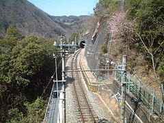
At Chūbu-Tenryū it reaches the Tenryū valley. Since the Sakuma reservoir submerged part of the original route, an alternative route through the neighboring Misakubo Valley had to be built in the 1950s. This includes the mine tunnel (3619 m) and the Ōhara tunnel (5062 m), the two longest tunnels on the Iida line. After the route has reached the Tenryū Valley again at Ōzore, it crosses the border to Nagano Prefecture . It leaves the Kiso Mountains at Tenryūkyō and enters the elongated Ina Basin . A slight turn to the west serves to open up the city center of Iida . Continuing to follow the Tenryū, the Iida line finally reaches Tatsuno station on the Chūō main line .
Trains
JR Central offers two types of train for national long-distance traffic. The Inaji ( 伊 那 路 ) express train runs twice a day from Toyohashi to Iida and back; while on the way it stops at nine train stations. The Misuzu ( み す ず ) express train runs once a day and connects Iida with Tatsuno , Okaya , Matsumoto and Nagano . In the 1960s to 1980s, the Japanese State Railways offered fast trains from Iida to Nagoya and Tokyo-Shinjuku , which were replaced by long-distance buses.
Individual regional trains run continuously from Toyohashi to Tatsuno, for which they need more than six hours. However, these are an exception. As a rule, the route in regional traffic is operationally divided into three sections. Trains between Toyohashi and Hon-Nagashino run every 30 to 60 minutes, with the section to Toyokawa being compressed to 15-minute intervals. The section between Hon-Nagashino and Tenryūkyō leads through a sparsely populated mountain region; accordingly, the offer is limited to one train every two to three hours. On the section between Tenryūkyō and Tatsuno, the regional trains run once an hour, with most of them being tied through to Okaya.
history
The Iida line was built over a period of four decades, with the opening of the first section in 1897 and the last gap closure in 1937. The following private railway companies were involved in the construction:
- the Toyokawa Tetsudō from Toyohashi to Ōmi
- the Hōraiji Tetsudō from Ōmi to Mikawa-Kawai
- the Sanshin Tetsudō from Mikawa-Kawai to Tenryūkyō
- and the Ina Denki Tetsudō from Tenryūkyō to Tatsuno
Some of the sections served as feeders to the construction sites of several hydropower plants in the central highlands , which is why they were electrified relatively early. With the nationalization of all railway systems, they were combined to form the Iida line in 1943. This has been owned by JR Central since 1987 .
Toyokawa Tetsudō and Hōraiji Tetsudō

On July 15, 1897, the Toyokawa Tetsudō opened the oldest section of the later Iida line, which led from Toyohashi to Toyokawa . The section to Mikawa-Ichinomiya went into operation seven days later. The line reached Shinshiro on April 25, 1898 and finally the terminus Ōmi on September 23, 1900. The construction costs were more than double the share capital, which is why the railway company had to go into massive debt; In 1901 the impending bankruptcy could only just be averted. In the 1920s, Toyokawa Tetsudō expanded into the tourism sector and on July 28, 1925, it introduced electrical operation on its route.
The section between Toyohashi and the Kozakai junction was expanded to two tracks, so that from April 1, 1926, trains from Aichi Denki Tetsudō (predecessor of today's Nagoya Tetsudō ) could run from Toyohashi to Nagoya . The next day the second track extended to Toyokawa. The subsidiary Hōraiji Tetsudō opened the line from Ōmi to Mikawa-Kawai on February 1, 1923 and electrified it on July 28, 1925 as well. The operation was carried out by the parent company, so no change was necessary. The Toyokawa Tetsudō was also involved in the Taguchi Tetsudō , whose route branched off in Hon-Nagashino .
Clashes with the trade unions resulted in prolonged strikes. The Toyokawa Tetsudō got into financial difficulties again and was taken over on December 5, 1938 together with its subsidiaries by the Nagoya Tetsudō. This opened a short branch line from Toyokawa to Nishi-Toyokawa on May 12, 1942, in order to open up an important arsenal of the Imperial Japanese Navy .
Ina Denki Tetsudō
When planning the Chūō main line , the state railway administration decided on a route through the Kiso valley instead of the Ina basin . Local politicians and business people asked for a concession for an electric tram . Ina Densha Kidō , founded in 1907, opened the section from Nishimachi to Ina-Matsushima on December 28, 1909. Several extensions followed at short intervals: on February 22, 1911 from Nishimachi to Kinoshita, on November 3, 1911 to Misono, on January 4, 1912 to Ina-Kita, on May 11, 1912 to Inashi and on December 27, 1913 to Miyada. From that point on, the line was no longer legally considered a tram, but a small train .
The line advanced from Miyada through the Ina Basin: on October 31, 1914 to Komagane and on December 26, 1914 to Ina-Fukuoka. Until then, Nishimachi was the northern terminus. After the construction of a bridge over the Yokokawa, the line could be extended to Tatsuno station on November 23, 1916 , which now connected it to the railway network. The southern end of the small train reached on February 11, 1918 to Iijima, on July 23, 1918 to Nanakubo, on December 12, 1918 to Takatōbara. The railway company then changed its name on August 20, 1919 to Ina Denki Tetsudō . It extended the route on November 22, 1920 to Kami-Katagiri, on July 13, 1922 to Ina-Ōshima, on January 15, 1923 to Yamabuki, on March 13, 1923 to Ichida, on March 18, 1923 to Moto-Zenkōji and on August 3, 1923 to Iida .
Due to the route flush with the street in the northern part, the small railroad reached its capacity limits. Therefore a new route according to the railway standard was created between Tatsuno and Ina-Matsushima, which went into operation on March 16, 1923. At the same time, the contact wire voltage was increased from 600 V to 1200 V and over a dozen stops were canceled. The Ina Denki Tetsudō then took four further extensions into operation: on December 17, 1926 from Iida to Ina-Yawata, on February 5, 1927 to Kega, on April 8, 1927 to Dashina and finally on December 26, 1927 to Tenryūkyō on the southern End of the Ina basin.
Sanshin Tetsudo

The railway company Sanshin Tetsudō , founded in 1927, set itself the goal of closing the 70 km long gap between Mikawa-Kawai and Tenryūkyō. After the construction work began in August 1929, it soon came to a standstill. The reasons for this were difficult geological conditions and the effects of the global economic crisis . To save costs, numerous poorly paid workers from Korea were deployed. In 1931 there was a construction freeze for several months. After a change of management and a capital increase, the first section from Tenryūkyō to Kadoshima could be opened on October 30, 1932.
Further sections were added as follows: from Mikawa-Kawai to Tōei on December 21, 1933, from Tōei to Chūbu-Tenryū on November 11, 1934, from Kadoshima to Nukuta on November 15, 1935, from Nukuta to Hiraoka on April 26, 1936 , from Chūbu-Tenryū to Tenryū-Yamamuro on November 10, 1936, from Tenryū-Yamamuro to Ōzore on December 29, 1936 and from Hiraoka to Kowada a day later. With the commissioning of the last section from Ōzore to Kowada on August 20, 1937, the line was completed.
Association to the Iida line

During the Pacific War , the state sought to bring under its control some strategically important private railways that had been established after the first wave of nationalization in 1906/07 . The Nationalization Act, which came into force on August 1, 1943, also affected the Hōraiji Tetsudō, the Ina Denki Tetsudō, the Sanshin Tetsudō and the Toyokawa Tetsudō. On that day, the Ministry of Railways combined the four sections to form the Iida line.
The construction of the Sakuma dam on Tenryū meant that a 13.3 km long section between Chūbu-Tenryū and Ōzore would be flooded by the filling reservoir. For this reason, the Japanese State Railways began in December 1953 with the construction of a 17.3 km long alternative route through the Misakubo Valley. Seven months after the contact wire voltage between Tatsuno and Tenryūkyō had been increased to 1500 V, the new line went into operation on November 11, 1955. The old stretch was flooded, but parts of it are still visible in the Sakuma reservoir when the water level is low. On September 15, 1956, the state railway stopped passenger services on the branch line to Nishi-Toyokawa. Because of a landslide on August 17, 1957, the Ōzore – Kowada section was interrupted for a month; During this time, people were transported with rented boats on the Tenryū.
In order to avoid a zone at risk of falling rocks, the Hiraoka – Ugusu section received a new route on June 13, 1982. In 1983, the last railcars from the pre-war period ran. As part of the privatization of the state railway, the Iida line passed into the possession of the new company JR Central on April 1, 1987 . JR Freight took over the freight traffic on the same day, but only on the Toyohashi – Toyokawa and Tatsuno – Moto-Zenkōji sections.
The Chūō-Shinkansen maglev train, which is currently under construction , is expected to connect Tokyo with Nagoya from 2027 and also open up the city of Iida . For this reason, the importance of the Iida line as a feeder route will increase. A new transfer station is planned to be built between the Ina-Kamisato and Moto-Zenkōji stops.
photos

Express train in Toyokawa

"Suruga Shuttle" at Yuya-Onsen (1990)

at Mikawa-Makihara

Tunnel at Aizuki
at Tamoto


Iida train station

Ina-Fukuoka Railway Station

Bridge over the Ōtagiri

Nanakubo Railway Station


List of train stations
| Surname | km | Connecting lines | location | place | prefecture |
|---|---|---|---|---|---|
| Toyohashi ( 豊 橋 ) | 0.0 |
Tōkaidō Shinkansen Tōkaidō Main Line Meitetsu Nagoya Main Line Toyohashi Tram at Shin-Toyohashi Station : Atsumi Line |
Coord. | Toyohashi | Aichi |
| Funamachi ( 船 町 ) | 1.5 | Coord. | |||
| Shimoji ( 下地 ) | 2.2 | Coord. | |||
| Kozakai ( 小 坂 井 ) | 4.4 | Coord. | Toyokawa | ||
| Ushikubo ( 牛 久保 ) | 6.6 | Coord. | |||
| Toyokawa ( 豊 川 ) | 8.7 |
Toyokawa-Inari Station: Meitetsu Toyokawa Line |
Coord. | ||
| Mikawa-Ichinomiya ( 三河 一 宮 ) | 12.0 | Coord. | |||
| Nagayama ( 長 山 ) | 14.4 | Coord. | |||
| Ejima ( 江 島 ) | 15.4 | Coord. | |||
| Tōjō ( 東 上 ) | 17.0 | Coord. | |||
| Nodajō ( 野 田 城 ) | 19.7 | Coord. | Shinshiro | ||
| Shinshiro ( 新城 ) | 21.6 | Coord. | |||
| Higashi-Shimmachi ( 東 新 町 ) | 22.6 | Coord. | |||
| Chausuyama ( 茶 臼 山 ) | 23.8 | Coord. | |||
| Mikawa-Tōgō ( 三 河東 郷 ) | 25.0 | Coord. | |||
| Ōmi ( 大海 ) | 27.9 | Coord. | |||
| Torii ( 鳥 居 ) | 29.3 | Coord. | |||
| Nagashinojō ( 長 篠 城 ) | 30.8 | Coord. | |||
| Hon-Nagashino ( 本 長 篠 ) | 32.1 | Coord. | |||
| Mikawa-Ōno ( 三河 大野 ) | 35.6 | Coord. | |||
| Yuya Onsen ( 湯 谷 温泉 ) | 38.0 | Coord. | |||
| Mikawa-Makihara ( 三河 槙 原 ) | 40.6 | Coord. | |||
| Kakidaira ( 柿 平 ) | 42.9 | Coord. | |||
| Mikawa-Kawai ( 三 河川 合 ) | 45.2 | Coord. | |||
| Ikeba ( 池 場 ) | 50.1 | Coord. | |||
| Tōei ( 東 栄 ) | 51.2 | Coord. | Tōei | ||
| Izumma ( 出馬 ) | 55.4 | Coord. | Tenryū-ku , Hamamatsu | Shizuoka | |
| Kamiichiba ( 上 市場 ) | 56.0 | Coord. | |||
| Urakawa ( 浦 川 ) | 57.3 | Coord. | |||
| Hayase ( 早 瀬 ) | 58.5 | Coord. | |||
| Shimokawai ( 下 川 合 ) | 59.9 | Coord. | |||
| Chūbu-Tenryū ( 中部 天 竜 ) | 62.4 | Coord. | |||
| Sakuma ( 佐 久 間 ) | 63.5 | Coord. | |||
| Aizuki ( 相 月 ) | 68.5 | Coord. | |||
| Shironishi ( 城西 ) | 70.5 | Coord. | |||
| Mukaichiba ( 向 市場 ) | 73.3 | Coord. | |||
| Misakubo ( 水窪 ) | 74.3 | Coord. | |||
| Ōzore ( 大 嵐 ) | 80.8 | Coord. | |||
| Kowada ( 小 和田 ) | 83.8 | Coord. | |||
| Nakaisamurai ( 中 井 侍 ) | 87.8 | Coord. | Tenryu | Nagano | |
| Ina-Kozawa ( 伊 那 小 沢 ) | 90.1 | Coord. | |||
| Ugusu ( 鶯 巣 ) | 91.7 | Coord. | |||
| Hiraoka ( 平 岡 ) | 93.8 | Coord. | |||
| Shiteguri ( 為 栗 ) | 98.5 | Coord. | |||
| Nukuta ( 温 田 ) | 102.2 | Coord. | Yasuoka | ||
| Tamoto ( 田 本 ) | 104.2 | Coord. | |||
| Kadoshima ( 門 島 ) | 107.9 | Coord. | |||
| Karakasa ( 唐 笠 ) | 111.3 | Coord. | |||
| Kinno ( 金 野 ) | 113.6 | Coord. | Iida | ||
| Chiyo ( 千代 ) | 114.8 | Coord. | |||
| Tenryūkyō ( 天 竜 峡 ) | 116.2 | Coord. | |||
| Kawaji ( 川 路 ) | 117.5 | Coord. | |||
| Tokimata ( 時又 ) | 119.3 | Coord. | |||
| Dashina ( 駄 科 ) | 121.1 | Coord. | |||
| Kega ( 毛 賀 ) | 122.5 | Coord. | |||
| Ina-Yawata ( 伊 那 八 幡 ) | 123.6 | Coord. | |||
| Shimoyamamura ( 下 山村 ) | 124.7 | Coord. | |||
| Kanae ( 鼎 ) | 125.7 | Coord. | |||
| Kiriishi ( 切 石 ) | 127.7 | Coord. | |||
| Iida ( 飯 田 ) | 129.3 | Coord. | |||
| Sakuramachi ( 桜 町 ) | 130.1 | Coord. | |||
| Ina-Kamisato ( 伊 那 上 郷 ) | 131.1 | Coord. | |||
| Moto-Zenkōji ( 元 善 光寺 ) | 133.8 | Coord. | |||
| Shimoichida ( 下 市 田 ) | 135.6 | Coord. | Takamori | ||
| Ichida ( 市 田 ) | 136.8 | Coord. | |||
| Shimodaira ( 下 平 ) | 139.5 | Coord. | |||
| Yamabuki ( 山 吹 ) | 140.5 | Coord. | |||
| Ina-Ōshima ( 伊 那 大 島 ) | 143.1 | Coord. | Matsukawa | ||
| Kami-Katagiri ( 上片 桐 ) | 146.9 | Coord. | |||
| Ina-Tajima ( 伊 那 田島 ) | 148.2 | Coord. | Nakagawa | ||
| Takatōbara ( 高遠 原 ) | 150.7 | Coord. | Iijima | ||
| Nanakubo ( 七 久保 ) | 152.3 | Coord. | |||
| Ina-Hongō ( 伊 那 本 郷 ) | 155.1 | Coord. | |||
| Iijima ( 飯 島 ) | 157.9 | Coord. | |||
| Tagiri ( 田 切 ) | 160.1 | Coord. | |||
| Ina-Fukuoka ( 伊 那 福岡 ) | 162.9 | Coord. | Komagans | ||
| Komachiya ( 小 町 屋 ) | 164.4 | Coord. | |||
| Komagane ( 駒 ケ 根 ) | 165.6 | Coord. | |||
| Ōtagiri ( 大田 切 ) | 167.0 | Coord. | |||
| Miyada ( 宮 田 ) | 169.1 | Coord. | Miyada | ||
| Akagi ( 赤木 ) | 170.4 | Coord. | Ina | ||
| Sawando ( 沢 渡 ) | 173.4 | Coord. | |||
| Shimojima ( 下 島 ) | 174.5 | Coord. | |||
| Inashi ( 伊 那 市 ) | 178.0 | Coord. | |||
| Ina-Kita ( 伊 那 北 ) | 178.9 | Coord. | |||
| Tabata ( 田 畑 ) | 181.0 | Coord. | Minamiminova | ||
| Kitatono ( 北 殿 ) | 183.2 | Coord. | |||
| Kinoshita ( 木 ノ 下 ) | 185.6 | Coord. | Minowa | ||
| Ina-Matsushima ( 伊 那 松 島 ) | 187.1 | Coord. | |||
| Sawa ( 沢 ) | 189.7 | Coord. | |||
| Haba ( 羽 場 ) | 191.6 | Coord. | Tatsuno | ||
| Ina-Shimmachi ( 伊 那 新 町 ) | 193.4 | Coord. | |||
| Miyaki ( 宮 木 ) | 194.6 | Coord. | |||
| Tatsuno ( 辰 野 ) | 195.7 | Chūō main line | Coord. |
Web links
- JR Central route network (PDF, 1.2 MB)
Individual evidence
- ↑ Shinichi Koizumi: Remote stations have great views if you know where to look. Asahi Shimbun , August 2, 2018, accessed March 10, 2019 .
- ↑ a b JR 時刻表 2018 年 3 月 号 (JR timetable March 2018). Kōtsū shinbunsha, Tokyo 2018.
- ↑ 運輸 開業 免 許 状 下 付. In: Official Gazette. National Library of Parliament , July 24, 1897, accessed March 10, 2019 (Japanese).
- ↑ 運輸 開業 免 許 状 下 付. In: Official Gazette. National Parliamentary Library, July 26, 1897, accessed March 10, 2019 (Japanese).
- ↑ 運輸 開業 免 許 状 下 付. In: Official Gazette. National Parliamentary Library, April 27, 1898, accessed March 10, 2019 (Japanese).
- ↑ 運輸 開業 免 許 状 下 付. In: Official Gazette. National Library of Parliament, September 27, 1900, accessed March 10, 2019 (Japanese).
- ↑ 地方 鉄 道 運輸 開始. In: Official Gazette. National Parliamentary Library, February 3, 1923, accessed March 10, 2019 (Japanese).
- ↑ 地方 鉄 道 軌道 営 業 年鑑. (Yearbook of the regional railway companies). National Library of Parliament, 1929, accessed March 10, 2019 (Japanese).
- ↑ 地方 鉄 道 運輸 開始. In: Official Gazette. National Parliamentary Library, May 20, 1942, accessed March 10, 2019 (Japanese).
- ↑ a b 箕 輪 町 史 自然 ・ 現代 編. Minowa City Council, September 25, 2014, archived from the original on March 4, 2016 ; Retrieved March 10, 2019 (Japanese).
- ↑ 電 気 事業 要 覧. 第 13 回. National Library of Parliament, 1919, accessed March 10, 2019 (Japanese).
- ↑ 地方 鉄 道 運輸 開始. In: Official Gazette. National Parliamentary Library, August 7, 1923, accessed March 10, 2019 (Japanese).
- ↑ 地方 鉄 道 運輸 開始. In: Official Gazette. National Library of Parliament, March 21, 1923, accessed March 10, 2019 (Japanese).
- ↑ 地方 鉄 道 運輸 開始. In: Official Gazette. National Parliamentary Library, January 19, 1928; accessed March 10, 2019 (Japanese).
- ↑ a b Tōkai Ryokaku Tetsudō Iida shiten (Ed.): 飯 田 線 ろ ま ん 100 年 史 ―1897-1997 . Shinba, 1997, ISBN 978-4-88242-076-7 , pp. 24-26 .
- ↑ 鉄 道 省 告示 第 204 号. In: Official Gazette. National Parliamentary Library, July 26, 1943, accessed March 10, 2019 (Japanese).
- ↑ Naoki Ōsaka: 初 代 社長 が 語 る 、 JR 東海 の 「観 光 列車 論」. Toyo Keizai Online, July 12, 2015, accessed March 10, 2019 (Japanese).
- ↑ Tetsu Ishino (Ed.): 停車場 変 遷 大事 典 国 鉄 ・ JR 編 . JTB, Tokyo 1998, ISBN 4-533-02980-9 (station change directory JNR / JR).
- ↑ リ ニ ア 駅 、 飯 田 市 座 光寺 ・ 上 郷 元 善 光寺 駅 南西 1 キ ロ. Shimai, August 26, 2013; archived from the original on August 28, 2013 ; Retrieved March 10, 2019 (Japanese).
Current lines: Tōkaidō-Shinkansen | Chūō main line | Gotemba Line | Iida line | Jōhoku Line | Kansai main line | Kisei main line | Meishō Line | Mino Akasaka Line | Minobu Line | Sangu line | Taita line | Takayama main line | Taketoyo line | Tōkaidō main line ( Atami – Toyohashi , Toyohashi – Maibara )
Released Lines: Nishi Nagoyakō Line | Okata line