Komagans
| Komagane-shi 駒 ヶ 根 市 |
||
|---|---|---|
| Geographical location in Japan | ||
|
|
||
| Region : | Chūbu | |
| Prefecture : | Nagano | |
| Coordinates : | 35 ° 44 ' N , 137 ° 56' E | |
| Basic data | ||
| Surface: | 165.92 km² | |
| Residents : | 32,197 (October 1, 2019) |
|
| Population density : | 194 inhabitants per km² | |
| Community key : | 20210-0 | |
| Symbols | ||
| Flag / coat of arms: | ||
| Tree : | Japanese red pine | |
| Flower : | lily of the valley | |
| Insect : | Nannophya pygmaea | |
| town hall | ||
| Address : |
Komagane City Hall 20 - 1 , Akasu-cho Komagane -shi Nagano 399-4192 |
|
| Website URL: | http://www.city.komagane.nagano.jp | |
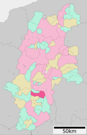
| Location Komaganes in Nagano Prefecture | ||
Komagane ( Japanese 駒 ヶ 根 市 , -shi ) is a city in the center of Nagano Prefecture on the Japanese main island of Honshu .
geography
The Tenryū River flows through the city from north to south.
history
The city of Komagane was founded on July 1, 1954 from the former communities of Akaho, Miyada , Nakazawa, and Ina. However, Miyada was spun off again on September 30, 1956 due to fierce popular resistance to integration.
traffic
Komagane is accessible via the Chūō Highway and National Road 153. The city is also on the JR Central- operated Iida Line , which connects Toyohashi with Tatsuno . From the train station Komagane from a bus leads to the station of Komagatake ropeway . This opens up the eastern slope of the mountain Hōkendake in the Kiso Mountains .
Neighboring cities and communities
Web links
Commons : Komagane - collection of images, videos and audio files
- Official website in Japanese


