Azumino
| Azumino-shi 安 曇 野 市 |
||
|---|---|---|
| Geographical location in Japan | ||
|
|
||
| Region : | Chūbu | |
| Prefecture : | Nagano | |
| Coordinates : | 36 ° 17 ' N , 137 ° 55' E | |
| Basic data | ||
| Surface: | 331.82 km² | |
| Residents : | 94,463 (October 1, 2019) |
|
| Population density : | 285 inhabitants per km² | |
| Community key : | 20220-7 | |
| Symbols | ||
| Flag / coat of arms: | ||
| town hall | ||
| Address : |
Azumino City Hall 4932 - 46 , Toyoshina Azumino -shi Nagano 399-8205 |
|
| Website URL: | http://www.city.azumino.nagano.jp | |
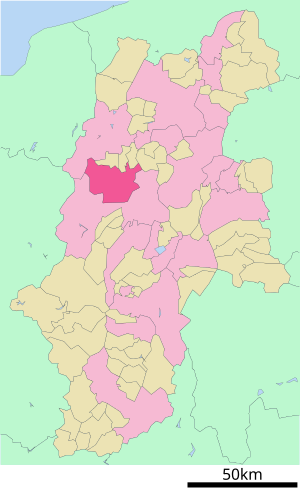
| Location Azuminos in Nagano Prefecture | ||
Azumino ( Japanese 安 曇 野 市 , -shi ) is a city in the center of Nagano Prefecture on the Japanese main island of Honshu .
history
The city of Azumino was founded on October 1, 2005 from the former parishes of Toyoshina, Hotaka, Misato and Horigane.
traffic
- Street:
- Nagano Highway
- National Road 19 : to Nagano and Nagoya
- National road 143,147,407
- Train:
Attractions
- Daiō wasabi farm ( 大王 わ さ び 農場 )
Town twinning
-
 Kramsach , since 1989
Neighboring cities and communities
Resident companies
- ALTUS Co. Ltd. (President Shuichi Tanaka ), flute manufacturer
- AZUMI instrument maker, named after the inhabitants of Azuminos
sons and daughters of the town
- Shōgo Asada (* 1998), football player
- Ogiwara Rokuzan (1879–1910), sculptor
Individual evidence
- ↑ Originally with Toyoshina.
- ^ Austrian-Japanese relations. Austrian Embassy Tokyo, archived from the original on December 19, 2012 ; accessed on August 16, 2016 .
Web links
Commons : Azumino - collection of images, videos and audio files
- Official tourism website in English
- Official website in Japanese


