Itoigawa
| Itoigawa-shi 糸 魚 川 市 |
||
|---|---|---|
|
|
||
| Geographical location in Japan | ||
| Region : | Chūbu | |
| Prefecture : | Niigata | |
| Coordinates : | 37 ° 2 ' N , 137 ° 52' E | |
| Basic data | ||
| Surface: | 749.24 km² | |
| Residents : | 41,325 (October 1, 2019) |
|
| Population density : | 55 inhabitants per km² | |
| Community key : | 15216-1 | |
| Symbols | ||
| Flag / coat of arms: | ||
| Tree : | Lilium japonicum | |
| Flower : | Ume | |
| town hall | ||
| Address : |
Itoigawa City Hall 1 - 2 - 5 , Ichinomiya Itoigawa -shi Niigata 941-8501 |
|
| Website URL: | http://www.city.itoigawa.lg.jp/ | |
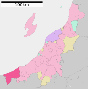
| Itoigawa's location in Niigata Prefecture | ||
Itoigawa ( Japanese 糸 魚 川 市 , - shi ) is a city in Niigata Prefecture in Japan .
geography
Itoigawa is located west of Jōetsu and east of Toyama on the Sea of Japan .
history
The city of Itoigawa was formed on June 1, 1954 from the former Machi Itoigawa ( 糸 魚 川 町 , -machi ), as well as the Mura Uramoto ( 浦 本村 , -mura ), Shimohayakawa ( 下 早 川村 , -mura ), Kamihayakawa ( 上 早 川村 , -mura ), Yamatogawa ( 大 和 川村 , -mura ), Saikai ( 西海 村 , -mura ), Ōno ( 大 野村 , -mura ), Nechi ( 根 知 村 , -mura ) and Kotaki ( 小 滝 村 , -mura ) des Nishikubiki County established. The village of Imai ( 今井 村 , -mura ) followed on October 1 of the same year . On March 19, 2005, the communities Nou ( 能 生 町 , -machi ) and Oumi ( 青海 町 , -machi ) of the same district were incorporated, which was then dissolved.
Attractions
-
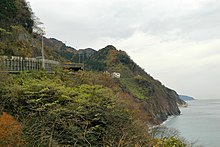
Oyashirazu ( 親 知 ら ず , dt. " Wisdom tooth ", actually literally "unknown to the parents" - based on the assumption that these teeth only appear when the children have already moved out of the parental home). The scree beach in front of Oyashirazu was a famous site for jadeite pebbles that were washed out of the Renge belt . In the meantime, however, the beach has largely been searched by local jade hunters and tourists, so that hardly any good pieces can be found. In addition to jadeite, the minerals natrolite , omphacite , pectolite , prehnite , xonotlite , zircon and the quartz variety chrysoprase were also found at Oyashirazu . For the minerals Itoigawait and Rengeit , the place is also considered a type locality .
traffic
- Street:
- Hokuriku Highway
- National road 8
- National road 148
- Train:
Neighboring cities and communities
- Niigata prefecture
- Nagano Prefecture
- Toyama prefecture
literature
- Nicholas Sure: My Mother is a Tractor. A Life in Rural Japan . Trafford, 2005, ISBN 978-1-4120-4897-2


