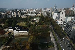
Toyama
| Toyama-shi 富山 市 |
||
|---|---|---|
| Geographical location in Japan | ||
|
|
||
| Region : | Chūbu | |
| Prefecture : | Toyama | |
| Coordinates : | 36 ° 42 ' N , 137 ° 13' E | |
| Basic data | ||
| Surface: | 1,241.85 km² | |
| Residents : | 415,816 (October 1, 2019) |
|
| Population density : | 335 inhabitants per km² | |
| Community key : | 16201-9 | |
| Symbols | ||
| Flag / coat of arms: | ||
| Tree : | Japanese zelkove | |
| Flower : | thistle | |
| Blooming tree: | azalea | |
| town hall | ||
| Address : |
Toyama City Hall 7 - 38 , Shinsakura-machi Toyama -shi Toyama 930-8510 |
|
| Website URL: | http://www.city.toyama.toyama.jp | |
| Location of Toyamas in Toyama Prefecture | ||
Toyama ( Japanese 富山 市 , - shi ) is a city and the administrative seat of Toyama Prefecture in Japan . It is located on Honshū , the main island of Japan, on the coast of the Sea of Japan at Toyama Bay . Toyama has been a university city since 1949 .
Toyama is an old castle town that was home to a branch of the Maeda clan with an income of 100,000 koku from the 17th century . Shortly before the end of the Second World War, the city was almost completely destroyed in an air raid on August 2, 1945.
In addition to mechanical engineering ( Nachi-Fujikoshi Corp. ), the pharmaceutical industry and an oil refinery are of economic importance. The Kamiokande experiment is taking place in a mine near the city , in which the lifespan of the proton is to be determined.
The waters off Toyama Bay are home to the luminous squid .
Neighboring cities and communities
Attractions
- Toyama Castle Ruins ( 富 山城 )
traffic
Air traffic:
Train:
Local transport:
- Toyama tram
- Toyama Light Rail / Toyama Light Rail
Street:
- Hokuriku Highway
- National road 8
- National road 41
- National roads 359, 360, 415, 471, 472
Sports
- Kataller Toyama (football club)
Town twinning
- Durham, North Carolina , United States, since 1989
- Qinhuangdao , People's Republic of China , since 1981
Personalities
- Kōdai Fujii (* 1991), football player
- Jō Inoue (* 1994), football player
- Yoshihisa Inoue (* 1947), Prefectural Governor
- Junki Mawatari (* 1996), football player
- Jin'en Nagase (* 1943), politician
- Hiroki Nakada (* 1992), football player
- Yōko Nogiwa (1936-2017), actress
- Shō Ōtsuka (* 1995), football player
- Shunsuke Tachino (* 1993), football player
- Kōichi Tanaka (* 1959), Nobel Prize Laureate in Chemistry in 2002
- Makoto Tateno , manga artist


