Oyabe
| Oyabe-shi 小 矢 部 市 |
||
|---|---|---|
|
|
||
| Geographical location in Japan | ||
| Region : | Chūbu | |
| Prefecture : | Toyama | |
| Coordinates : | 36 ° 41 ′ N , 136 ° 52 ′ E | |
| Basic data | ||
| Surface: | 134.11 km² | |
| Residents : | 29,081 (October 1, 2019) |
|
| Population density : | 217 inhabitants per km² | |
| Community key : | 16209-4 | |
| Symbols | ||
| Tree : | Miyajima crescent fir | |
| Flower : | Japanese iris | |
| Tree blossom: | red Ume blossoms | |
| town hall | ||
| Address : |
Oyabe City Hall 1 - 1 , Hon-machi Oyabe -shi Toyama 932-8611 |
|
| Website URL: | http://www.city.oyabe.toyama.jp | |
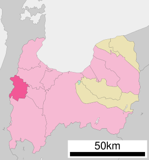
| Location of Oyabes in Toyama Prefecture | ||
Oyabe ( Japanese 小 矢 部 市 , -shi ) is a city in Toyama Prefecture in Japan .
geography
Oyabe is west of Toyama and southwest of Takaoka .
history
The city of Oyabe was founded on October 1st, 1958 .
traffic
- Street:
- Hokuriku Highway
- National Road 8 , to Kyoto and Niigata
- National Road 359, to Toyama and Kanazawa
- National Road 471, to Hakui and Takayama
- Train:
Neighboring cities and communities
Web links
Commons : Oyabe - collection of images, videos and audio files
- Official website in Japanese

