
Tōkaidō main line (Atami – Toyohashi)
| Tōkaidō main line (Atami – Toyohashi) | |||||||||||||||||||||||||||||||||||||||||||||||||||||||||||||||||||||||||||||||||||||||||||||||||||||||||||||||||||||||||||||||||||||||||||||||||||||||||||||||||||||||||||||||||||||||||||||||||||||||||||||||||||||||||||||||||||||||||||||||||||||||||||||||||||||||||||||||||||||||||||||||||||||||||||||||||||||||||||||||||||||||||||||||||||||||||||||||||||||||||||||||||||||||||||||||||||||||||||||||||||||||||||||||||||||||||||||||||||||||||||||||||||||||||||||||||||||||||||||||||||||||||||||||||||||||||||||||||||||||||||||||||||||||||||||||||||||||||
|---|---|---|---|---|---|---|---|---|---|---|---|---|---|---|---|---|---|---|---|---|---|---|---|---|---|---|---|---|---|---|---|---|---|---|---|---|---|---|---|---|---|---|---|---|---|---|---|---|---|---|---|---|---|---|---|---|---|---|---|---|---|---|---|---|---|---|---|---|---|---|---|---|---|---|---|---|---|---|---|---|---|---|---|---|---|---|---|---|---|---|---|---|---|---|---|---|---|---|---|---|---|---|---|---|---|---|---|---|---|---|---|---|---|---|---|---|---|---|---|---|---|---|---|---|---|---|---|---|---|---|---|---|---|---|---|---|---|---|---|---|---|---|---|---|---|---|---|---|---|---|---|---|---|---|---|---|---|---|---|---|---|---|---|---|---|---|---|---|---|---|---|---|---|---|---|---|---|---|---|---|---|---|---|---|---|---|---|---|---|---|---|---|---|---|---|---|---|---|---|---|---|---|---|---|---|---|---|---|---|---|---|---|---|---|---|---|---|---|---|---|---|---|---|---|---|---|---|---|---|---|---|---|---|---|---|---|---|---|---|---|---|---|---|---|---|---|---|---|---|---|---|---|---|---|---|---|---|---|---|---|---|---|---|---|---|---|---|---|---|---|---|---|---|---|---|---|---|---|---|---|---|---|---|---|---|---|---|---|---|---|---|---|---|---|---|---|---|---|---|---|---|---|---|---|---|---|---|---|---|---|---|---|---|---|---|---|---|---|---|---|---|---|---|---|---|---|---|---|---|---|---|---|---|---|---|---|---|---|---|---|---|---|---|---|---|---|---|---|---|---|---|---|---|---|---|---|---|---|---|---|---|---|---|---|---|---|---|---|---|---|---|---|---|---|---|---|---|---|---|---|---|---|---|---|---|---|---|---|---|---|---|---|---|---|---|---|---|---|---|---|---|---|---|---|---|---|---|---|---|---|---|---|---|---|---|---|---|---|---|---|---|---|---|---|---|---|---|---|---|---|---|---|---|---|---|---|---|---|---|---|---|---|---|---|---|---|---|---|---|---|---|---|---|---|---|---|---|---|---|---|---|---|---|---|---|---|---|---|---|---|---|---|---|---|---|---|---|---|---|---|---|---|---|---|---|---|---|---|---|---|---|---|---|---|---|---|---|---|---|---|---|---|---|---|---|---|---|---|---|---|---|---|---|---|---|---|---|---|---|---|---|---|---|---|---|---|---|---|---|---|---|---|---|---|---|---|---|---|---|---|---|---|---|---|---|---|---|---|---|---|---|---|---|
 Class 117 multiple unit on the bridge to Benten-jima island
| |||||||||||||||||||||||||||||||||||||||||||||||||||||||||||||||||||||||||||||||||||||||||||||||||||||||||||||||||||||||||||||||||||||||||||||||||||||||||||||||||||||||||||||||||||||||||||||||||||||||||||||||||||||||||||||||||||||||||||||||||||||||||||||||||||||||||||||||||||||||||||||||||||||||||||||||||||||||||||||||||||||||||||||||||||||||||||||||||||||||||||||||||||||||||||||||||||||||||||||||||||||||||||||||||||||||||||||||||||||||||||||||||||||||||||||||||||||||||||||||||||||||||||||||||||||||||||||||||||||||||||||||||||||||||||||||||||||||||
| Route length: | 189.0 km | ||||||||||||||||||||||||||||||||||||||||||||||||||||||||||||||||||||||||||||||||||||||||||||||||||||||||||||||||||||||||||||||||||||||||||||||||||||||||||||||||||||||||||||||||||||||||||||||||||||||||||||||||||||||||||||||||||||||||||||||||||||||||||||||||||||||||||||||||||||||||||||||||||||||||||||||||||||||||||||||||||||||||||||||||||||||||||||||||||||||||||||||||||||||||||||||||||||||||||||||||||||||||||||||||||||||||||||||||||||||||||||||||||||||||||||||||||||||||||||||||||||||||||||||||||||||||||||||||||||||||||||||||||||||||||||||||||||||||
| Gauge : | 1067 mm ( cape track ) | ||||||||||||||||||||||||||||||||||||||||||||||||||||||||||||||||||||||||||||||||||||||||||||||||||||||||||||||||||||||||||||||||||||||||||||||||||||||||||||||||||||||||||||||||||||||||||||||||||||||||||||||||||||||||||||||||||||||||||||||||||||||||||||||||||||||||||||||||||||||||||||||||||||||||||||||||||||||||||||||||||||||||||||||||||||||||||||||||||||||||||||||||||||||||||||||||||||||||||||||||||||||||||||||||||||||||||||||||||||||||||||||||||||||||||||||||||||||||||||||||||||||||||||||||||||||||||||||||||||||||||||||||||||||||||||||||||||||||
| Power system : | 1500 V = | ||||||||||||||||||||||||||||||||||||||||||||||||||||||||||||||||||||||||||||||||||||||||||||||||||||||||||||||||||||||||||||||||||||||||||||||||||||||||||||||||||||||||||||||||||||||||||||||||||||||||||||||||||||||||||||||||||||||||||||||||||||||||||||||||||||||||||||||||||||||||||||||||||||||||||||||||||||||||||||||||||||||||||||||||||||||||||||||||||||||||||||||||||||||||||||||||||||||||||||||||||||||||||||||||||||||||||||||||||||||||||||||||||||||||||||||||||||||||||||||||||||||||||||||||||||||||||||||||||||||||||||||||||||||||||||||||||||||||
| Top speed: | 110 km / h | ||||||||||||||||||||||||||||||||||||||||||||||||||||||||||||||||||||||||||||||||||||||||||||||||||||||||||||||||||||||||||||||||||||||||||||||||||||||||||||||||||||||||||||||||||||||||||||||||||||||||||||||||||||||||||||||||||||||||||||||||||||||||||||||||||||||||||||||||||||||||||||||||||||||||||||||||||||||||||||||||||||||||||||||||||||||||||||||||||||||||||||||||||||||||||||||||||||||||||||||||||||||||||||||||||||||||||||||||||||||||||||||||||||||||||||||||||||||||||||||||||||||||||||||||||||||||||||||||||||||||||||||||||||||||||||||||||||||||
| Dual track : | whole route | ||||||||||||||||||||||||||||||||||||||||||||||||||||||||||||||||||||||||||||||||||||||||||||||||||||||||||||||||||||||||||||||||||||||||||||||||||||||||||||||||||||||||||||||||||||||||||||||||||||||||||||||||||||||||||||||||||||||||||||||||||||||||||||||||||||||||||||||||||||||||||||||||||||||||||||||||||||||||||||||||||||||||||||||||||||||||||||||||||||||||||||||||||||||||||||||||||||||||||||||||||||||||||||||||||||||||||||||||||||||||||||||||||||||||||||||||||||||||||||||||||||||||||||||||||||||||||||||||||||||||||||||||||||||||||||||||||||||||
| Society: | JR Central | ||||||||||||||||||||||||||||||||||||||||||||||||||||||||||||||||||||||||||||||||||||||||||||||||||||||||||||||||||||||||||||||||||||||||||||||||||||||||||||||||||||||||||||||||||||||||||||||||||||||||||||||||||||||||||||||||||||||||||||||||||||||||||||||||||||||||||||||||||||||||||||||||||||||||||||||||||||||||||||||||||||||||||||||||||||||||||||||||||||||||||||||||||||||||||||||||||||||||||||||||||||||||||||||||||||||||||||||||||||||||||||||||||||||||||||||||||||||||||||||||||||||||||||||||||||||||||||||||||||||||||||||||||||||||||||||||||||||||
|
|||||||||||||||||||||||||||||||||||||||||||||||||||||||||||||||||||||||||||||||||||||||||||||||||||||||||||||||||||||||||||||||||||||||||||||||||||||||||||||||||||||||||||||||||||||||||||||||||||||||||||||||||||||||||||||||||||||||||||||||||||||||||||||||||||||||||||||||||||||||||||||||||||||||||||||||||||||||||||||||||||||||||||||||||||||||||||||||||||||||||||||||||||||||||||||||||||||||||||||||||||||||||||||||||||||||||||||||||||||||||||||||||||||||||||||||||||||||||||||||||||||||||||||||||||||||||||||||||||||||||||||||||||||||||||||||||||||||||
This article describes the part of the Tōkaidō Main Line , one of the most important railway lines in Japan , located in the eastern half of the Chūbu region . The kapspurige , city, Shizuoka centered leg is 189.0 km long and is used by the railway company JR Central operates. From Atami it leads via Shizuoka and Hamamatsu to Toyohashi . It is almost entirely in Shizuoka Prefecture , the westernmost part of Aichi Prefecture .
The general features and history of the entire Tokyo - Kobe route are covered in the main article. Further sections:
- Tōkaidō main line (Tokyo – Atami)
- Tōkaidō main line (Toyohashi – Maibara)
- Biwako Line (Maibara – Kyōto)
- JR Kyōto Line (Kyōto – Osaka)
- JR Kobe Line (Osaka – Kobe)
Route description
The eastern starting point is Atami train station . The following Kinomiya station is only served by trains on the Itō line , but Tōkaidō trains from JR East use it to turn around. The area of responsibility of JR Central and the 7804 m long Tanna tunnel begin immediately afterwards . This leads through the tectonically active foothills of the Taga volcano to Mishima . In Numazu the route reaches the coast again. The section described above was only created four decades after the completion of the Tōkaidō main line; Until then, the trains between Kōzu and Numazu drove today's Gotemba line , which circles the Hakone mountain range on its north side.
South of the Ashitaka volcano, we continue along Suruga Bay . After crossing the Fuji River , the route turns south-west and follows a very narrow coastal strip. In the area of the Satta Pass, the Tōkaidō main line, the national road 1 and the Tōmei motorway run parallel in a very small space. After the prefectural capital of Shizuoka and the crossing of the Abe, there follows a stretch of coast characterized by steep cliffs. Originally the route in this area led through two tunnels directly on the coast. Since the route strongly rockfall was, it was replaced in 1942 by the 2,174 m long tunnel Nihonzaka and left to decay since then. The Tōkaidō main line used the Nihonzaka tunnel until 1962, when it was transferred to the Tōkaidō Shinkansen high-speed line, which was then under construction . The Ishibe tunnel with a length of 2205 m was built as a replacement.
Over the Shida plain, the route runs back inland and bridges the Ōi at Kanaya . Then the Makinohara plateau near Kikugawa is overcome with the 1056 m long Makinohara tunnel and a winding route , before the route approaches the coast again. She crosses the Tenryū and reaches the city of Hamamatsu . On the western outskirts, it crosses Lake Hamana parallel to the Tōkaidō Shinkansen . For this purpose, it is led over Benten-jima, an island in the estuary. Immediately after Shinjohara is the border with Aichi Prefecture . Finally the section ends in Toyohashi .
Trains
The supra-regional long-distance traffic is now largely handled on the parallel high-speed route Tōkaidō-Shinkansen . There are no express trains that travel the entire length of the Atami – Toyohashi section. In contrast , there are so-called "Limited Express" ( 新 快速 , Shin kaisoku ), which operate on a shorter section of the Tōkaidō main line and on an adjoining route. These include the Fujikawa ( ふ じ か わ ) from Shizuoka to Kōfu or the Odoriko ( 踊 り 子 ) from Tokyo via Mishima to Shuzenji . The Home Liner ( ホ ー ム ラ イ ナ ー ) from Numazu via Shizuoka to Hamamatsu is an express train with reserved seats during peak traffic.
Regional trains run three to six times an hour, depending on the route section and time of day. Here, too, it is true that no train covers the entire distance between Atami and Toyohashi; also can train movements and train lengths vary. Some trains run from Hamamatsu to Nagoya , so there is no need to change trains in Toyohashi. The night trains Sunrise Izumo ( サ ン ラ イ ズ 出 雲 ) and Sunrise Seto ( サ ン ラ イ ズ 瀬 戸 ) also operate on the Tōkaidō main line. The rail freight by JR Freight handled.
photos

West portal of the Tanna Tunnel
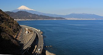
Narrow point at the Satta Pass, at the back left Mount Fuji

Seikenji Temple near Shizuoka
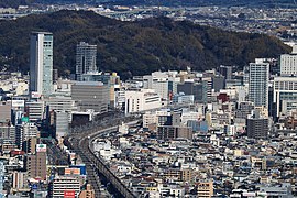
View of Shizuoka Railway Station

old Ishibe tunnel, left to decay

Class 313 multiple unit in Kakegawa


Chronology of important events
- Sep 1 1888: The ( Ōbu -) Toyohashi - Hamamatsu line opens ; in Ōbu connection to the existing route to Nagoya
- Feb. 1, 1889: Opening of the line ( Kōzu - Gotemba -) Numazu - Fuji - Shizuoka ; corresponds to today's Gotemba line between Kōzu and Numazu ; in Kōzu connection to the existing line to Tokyo
- July 1, 1889: the Shizuoka - Hamamatsu line opens; End-to-end connection Tokyo - Kobe completed
- April 1, 1895: Introduction of the route designation Tōkaidō Line (Tōkaidō-sen)
- July 15, 1898: second track between Kambara and Okitsu
- December 25, 1898: second track between Kambara and Fujikawa and between Okitsu and Shizuoka
- Feb. 24, 1899: second track between Numazu and Yoshiwara
- Nov. 5, 1900: second track between Yoshiwara and Fujikawa
- July 6, 1903: second track between Toyohashi and Washizu
- Dec. 7, 1903: second track between Kanaya and Kikugawa
- Feb. 8, 1904: second track between Hamamatsu and Maisaka
- Aug. 5, 1904: second track between Maisaka and Washizu
- Feb. 20, 1905: second track between Tenryūgawa and Hamamatsu
- Apr. 5, 1905: second track between Kikugawa and Kakegawa
- April 20, 1907: second track between Yaizu and Shimada
- Nov. 1, 1907: Opening of the branching port railway Numazu – Numazukō
- Dec. 20, 1907: second track between Kakegawa and Fukuroi
- 28 Mar 1908: second track between Fukuroi and Iwata
- Nov. 5, 1908: second track between Iwata and Tenryū Bridge
- October 12, 1909: Introduction of the route name Tōkaidō Main Line (Tōkaidō-honsen)
- Nov. 1, 1910: second track between Yaizu and the temporary signal station Isohama
- 10 Mar 1911: second track between the temporary signal station Isohama and Mochimune
- July 27, 1912: second track between Shimada and Kanaya
- Aug 1, 1913: second track between Tenryū Bridge and Tenryūgawa; Double-lane expansion of the entire Tōkaidō main line completed
- April 1, 1918: Construction of the Tanna Tunnel begins
- Dec. 1, 1934: Opening of the Numazu - Atami line and the Tanna tunnel (electrified double track); No detour via Gotemba (outsourced as Gotemba line)
- Dec. 1944: changed routing between Mochimune and Yaizu through the newly opened Nihonzaka tunnel; Closure of the old Ishibe and Isohama Tunnels
- Feb. 1, 1949: Electrification of the line between Numazu and Shizuoka
- May 20, 1949: Electrification of the line between Shizuoka and Hamamatsu
- July 21, 1953: Electrification of the line between Hamamatsu and Toyohashi (or on to Nagoya)
- 28 Sep 1962: Changed route between Mochimune and Yaizu through the new (and longer) Ishibe tunnel; Use of the Nihonzaka tunnel for the Tōkaidō Shinkansen
- Sep 1 1974: Closure of the Numazu – Numazukō port railway
- April 1, 1987: Privatization of the Japanese State Railways and transfer of the Atami - Shizuoka - Toyohashi section of the Tōkaidō main line to the newly established JR Central
- Oct. 6, 2014: Closure of the entire Atami - Toyohashi section after landslides as a result of Typhoon Phanfone ; Staged repairs take ten days
List of train stations
| Surname | km | Connecting lines | location | place | prefecture | |
|---|---|---|---|---|---|---|
| CA00 | Atami ( 熱 海 ) | 104.6 |
Tōkaidō Shinkansen Tōkaidō Main Line (Tokyo – Atami) Itō Line |
Coord. | Atami | Shizuoka |
| CA01 | Kannami ( 函 南 ) | 114.5 | Coord. | Kannami | ||
| CA02 | Mishima ( 三島 ) | 120.7 |
Tōkaidō Shinkansen Sunzu Line |
Coord. | Mishima | |
| CA03 | Numazu ( 沼 津 ) | 126.2 | Gotemba line | Coord. | Numazu | |
| CA04 | Katahama ( 片 浜 ) | 130.3 | Coord. | |||
| CA05 | Hara ( 原 ) | 132.8 | Coord. | |||
| CA06 | Higashi-Tagonoura ( 東 田 子 の 浦 ) | 137.4 | Coord. | Fuji | ||
| CA07 | Yoshiwara ( 吉 原 ) | 141.3 | Gakunan line | Coord. | ||
| CA08 | Fuji ( 富士 ) | 146.2 | Minobu line | Coord. | ||
| CA09 | Fujikawa ( 富 士川 ) | 149.7 | Coord. | |||
| CA10 | Shin-Kambara ( 新 蒲 原 ) | 152.5 | Coord. | Shizuoka | ||
| CA11 | Kambara ( 蒲 原 ) | 154.9 | Coord. | |||
| CA12 | Yui ( 由 比 ) | 158.4 | Coord. | |||
| CA13 | Okitsu ( 興 津 ) | 164.3 | Coord. | |||
| CA14 | Shimizu ( 清水 ) | 169.0 | Coord. | |||
| CA15 | Kusanagi ( 草 薙 ) | 174.2 | Shizuoka-Shimizu Line | Coord. | ||
| CA16 | Higashi-Shizuoka ( 東 静岡 ) | 177.7 | Coord. | |||
| CA17 | Shizuoka ( 静岡 ) | 180.2 | Tōkaidō Shinkansen | Coord. | ||
| CA18 | Abekawa ( 安 倍 川 ) | 184.5 | Coord. | |||
| CA19 | Mochimune ( 用 宗 ) | 186.8 | Coord. | |||
| CA20 | Yaizu ( 焼 津 ) | 193.7 | Coord. | Yaizu | ||
| CA21 | Nishi-Yaizu ( 西 焼 津 ) | 197.0 | Coord. | |||
| CA22 | Fujieda ( 藤枝 ) | 200.3 | Coord. | Fujieda | ||
| CA23 | Rokugō ( 六合 ) | 204.9 | Coord. | Shimada | ||
| CA24 | Shimada ( 島 田 ) | 207.8 | Coord. | |||
| CA25 | Kanaya ( 金谷 ) | 212.9 | Ōigawa main line | Coord. | ||
| CA26 | Kikugawa ( 菊 川 ) | 222.2 | Coord. | Kikugawa | ||
| CA27 | Kakegawa ( 掛 川 ) | 229.3 |
Tōkaidō Shinkansen Tenryū Hamanako Line |
Coord. | Kakegawa | |
| CA28 | Aino ( 愛 野 ) | 234.6 | Coord. | Fukuroi | ||
| CA29 | Fukuroi ( 袋 井 ) | 238.1 | Coord. | |||
| CA31 | Iwata ( 磐田 ) | 245.9 | Coord. | Iwata | ||
| CA32 | Toyodachō ( 豊 田 町 ) | 248.8 | Coord. | |||
| CA33 | Tenryūgawa ( 天 竜 川 ) | 252.7 | Coord. | Hamamatsu | ||
| CA34 | Hamamatsu ( 浜 松 ) | 257.1 |
Tōkaidō Shinkansen at Shin-Hamamatsu Station : Enshū Railway Line |
Coord. | ||
| CA35 | Takatsuka ( 高 塚 ) | 262.4 | Coord. | |||
| CA36 | Maisaka ( 舞 阪 ) | 267.5 | Coord. | |||
| CA37 | Bentenjima ( 弁 天 島 ) | 269.8 | Coord. | |||
| CA38 | Araimachi ( 新居 町 ) | 272.9 | Coord. | Kosai | ||
| CA39 | Washizu ( 鷲 津 ) | 276.8 | Coord. | |||
| CA40 | Shinjohara ( 新 所 原 ) | 282.4 | Tenryu-Hamanako Line | Coord. | ||
| CA41 | Futagawa ( 二 川 ) | 286.7 | Coord. | Toyohashi | Aichi | |
| CA42 | Toyohashi ( 豊 橋 ) | 293.6 |
Tōkaidō Shinkansen Tōkaidō Main Line (Toyohashi – Maibara) Iida Line Meitetsu Nagoya Main Line Toyohashi Tram at Shin-Toyohashi Station : Atsumi Line |
Coord. | ||
Web links
- JR Central route network (PDF, 1.2 MB)
Individual evidence
- ^ History of Shinkansen. In: Shinkansen Bullet Train. Encyclopedia Japan, accessed July 31, 2018 .
- ↑ a b JR 時刻表 2016 年 3 月 号 (JR timetable March 2016). Kōtsū shinbunsha, Tokyo 2016.
- ↑ 東海 道 本 線 由 比 駅 ~ 興 津 駅 間 の 運 転 再 開 に つ い て. JR Central, October 14, 2014, accessed July 31, 2018 (Japanese).
Current lines: Tōkaidō-Shinkansen | Chūō main line | Gotemba Line | Iida line | Jōhoku Line | Kansai main line | Kisei main line | Meishō Line | Mino Akasaka Line | Minobu Line | Sangu line | Taita line | Takayama main line | Taketoyo line | Tōkaidō main line ( Atami – Toyohashi , Toyohashi – Maibara )
Released Lines: Nishi Nagoyakō Line | Okata line