
Bivouac line
| Bivouac line | |||||||||||||||||||||||||||||||||||||||||||||||||||||||||||||||||||||||||||||||||||||||||||||||||||||||||||||||||||||||||||||||||||||||||||||||||||||||||||||||||||||||||||||||||||||||||||||||||||||||||||||||||||||||||||||||||||||||||||||||||||||||||||||||||||||||||||||||||||||||||||||||||||||||||||||||||||||||||||||||||||||||||||||
|---|---|---|---|---|---|---|---|---|---|---|---|---|---|---|---|---|---|---|---|---|---|---|---|---|---|---|---|---|---|---|---|---|---|---|---|---|---|---|---|---|---|---|---|---|---|---|---|---|---|---|---|---|---|---|---|---|---|---|---|---|---|---|---|---|---|---|---|---|---|---|---|---|---|---|---|---|---|---|---|---|---|---|---|---|---|---|---|---|---|---|---|---|---|---|---|---|---|---|---|---|---|---|---|---|---|---|---|---|---|---|---|---|---|---|---|---|---|---|---|---|---|---|---|---|---|---|---|---|---|---|---|---|---|---|---|---|---|---|---|---|---|---|---|---|---|---|---|---|---|---|---|---|---|---|---|---|---|---|---|---|---|---|---|---|---|---|---|---|---|---|---|---|---|---|---|---|---|---|---|---|---|---|---|---|---|---|---|---|---|---|---|---|---|---|---|---|---|---|---|---|---|---|---|---|---|---|---|---|---|---|---|---|---|---|---|---|---|---|---|---|---|---|---|---|---|---|---|---|---|---|---|---|---|---|---|---|---|---|---|---|---|---|---|---|---|---|---|---|---|---|---|---|---|---|---|---|---|---|---|---|---|---|---|---|---|---|---|---|---|---|---|---|---|---|---|---|---|---|---|---|---|---|---|---|---|---|---|---|---|---|---|---|---|---|---|---|---|---|---|---|---|---|---|---|---|---|---|---|---|---|---|---|---|---|---|---|---|---|---|---|---|---|---|---|---|---|---|---|---|---|---|---|---|
| Route length: | 75.4 km | ||||||||||||||||||||||||||||||||||||||||||||||||||||||||||||||||||||||||||||||||||||||||||||||||||||||||||||||||||||||||||||||||||||||||||||||||||||||||||||||||||||||||||||||||||||||||||||||||||||||||||||||||||||||||||||||||||||||||||||||||||||||||||||||||||||||||||||||||||||||||||||||||||||||||||||||||||||||||||||||||||||||||||||
| Gauge : | 1067 mm ( cape track ) | ||||||||||||||||||||||||||||||||||||||||||||||||||||||||||||||||||||||||||||||||||||||||||||||||||||||||||||||||||||||||||||||||||||||||||||||||||||||||||||||||||||||||||||||||||||||||||||||||||||||||||||||||||||||||||||||||||||||||||||||||||||||||||||||||||||||||||||||||||||||||||||||||||||||||||||||||||||||||||||||||||||||||||||
| Power system : | 1500 V = | ||||||||||||||||||||||||||||||||||||||||||||||||||||||||||||||||||||||||||||||||||||||||||||||||||||||||||||||||||||||||||||||||||||||||||||||||||||||||||||||||||||||||||||||||||||||||||||||||||||||||||||||||||||||||||||||||||||||||||||||||||||||||||||||||||||||||||||||||||||||||||||||||||||||||||||||||||||||||||||||||||||||||||||
| Top speed: | 130 km / h | ||||||||||||||||||||||||||||||||||||||||||||||||||||||||||||||||||||||||||||||||||||||||||||||||||||||||||||||||||||||||||||||||||||||||||||||||||||||||||||||||||||||||||||||||||||||||||||||||||||||||||||||||||||||||||||||||||||||||||||||||||||||||||||||||||||||||||||||||||||||||||||||||||||||||||||||||||||||||||||||||||||||||||||
| Dual track : | whole route | ||||||||||||||||||||||||||||||||||||||||||||||||||||||||||||||||||||||||||||||||||||||||||||||||||||||||||||||||||||||||||||||||||||||||||||||||||||||||||||||||||||||||||||||||||||||||||||||||||||||||||||||||||||||||||||||||||||||||||||||||||||||||||||||||||||||||||||||||||||||||||||||||||||||||||||||||||||||||||||||||||||||||||||
| Society: | JR West | ||||||||||||||||||||||||||||||||||||||||||||||||||||||||||||||||||||||||||||||||||||||||||||||||||||||||||||||||||||||||||||||||||||||||||||||||||||||||||||||||||||||||||||||||||||||||||||||||||||||||||||||||||||||||||||||||||||||||||||||||||||||||||||||||||||||||||||||||||||||||||||||||||||||||||||||||||||||||||||||||||||||||||||
|
|||||||||||||||||||||||||||||||||||||||||||||||||||||||||||||||||||||||||||||||||||||||||||||||||||||||||||||||||||||||||||||||||||||||||||||||||||||||||||||||||||||||||||||||||||||||||||||||||||||||||||||||||||||||||||||||||||||||||||||||||||||||||||||||||||||||||||||||||||||||||||||||||||||||||||||||||||||||||||||||||||||||||||||
Biwako line ( Japanese 琵琶湖 線 , Biwako-sen ) is the name used since 1988 for two contiguous sections of the Hokuriku main line and the Tōkaidō main line in the Japanese prefectures of Shiga and Kyōto . The line operated by the JR West railway company begins in Nagahama and leads via Maibara to Kyoto . Together with the JR Kyōto Line and the JR Kobe Line , the Biwako Line forms the main line of the urban rail network of JR West in the metropolitan region of Keihanshin (Kyōto / Osaka / Kobe ).
The general features and history of the entire Tokyo – Kobe line of the Tōkaidō main line are covered in the main article. Further sections:
- Tōkaidō main line (Tokyo – Atami)
- Tōkaidō main line (Atami – Toyohashi)
- Tōkaidō main line (Toyohashi – Maibara)
- JR Kyōto Line (Kyōto – Osaka)
- JR Kobe Line (Osaka – Kobe)
Surname
The Biwako Line is named after Lake Biwa ( 琵琶湖 , Biwa-ko ) in the center of the Japanese main island of Honshū . The Japanese State Railways used the informal name Kotō-sen 湖 東線 (Eng. "Sea East Line") for the Osaka - Maibara section of the Tōkaidō main line . After the state railroad privatization on April 1, 1987, the new company JR West intended to introduce the name JR Kyoto Line. However, opposition arose from politicians from Shiga Prefecture , who feared that the region would be seen merely as an appendage of the city of Kyoto . JR West therefore introduced the name Biwako Line for the Kyōto – Maibara section when the timetable was changed on March 5, 1988. The Maibara– Nagahama section of the Hokuriku main line was switched from 20 kV 50 Hz AC to 1500 V DC on September 14, 1991 . Since then, this section has also been part of the Biwako Line and all trains run continuously.
Route description
The Biwako Line is 67.7 km long and electrified with 1500 V DC. It has four tracks between Kyoto and Kusatsu , otherwise two tracks. It begins in Nagahama , the starting point of an earlier route of the Tōkaidō main line to Sekigahara , and initially leads along the east bank of Lake Biwa to the Maibara junction . There is the limit of the areas of responsibility of JR Central and JR West, as well as the transition between Hokuriku and Tōkaidō main line.
After Hikone , the route turns to the southeast and crosses the extensive Ōmi basin, about three to five kilometers from the lake shore. In this area it follows the historical traffic route Chōsenjin Kaidō ("Street of the Koreans"). This part is characterized by long straights and several river crossings. A special feature is the tunneling under the Kusatsu-gawa, the riverbed of which lies above the level of the surrounding plain. With the bridge over the Seta-gawa , the route reaches the southern end of the lake at Ishiyama . Within the city of Ōtsu there is a competitive situation with the partly parallel routes of the Keihan Denki Tetsudō .
In the first decade of the existence of the Tōkaidō main line there was a hairpin in Zeze station, so that the trains from Kyoto to Hama-Ōtsu (today Biwako-Hamaōtsu ) could get. There there was a connection to a steamship line across the lake to Nagahama (the branch line Zeze – Hama-Ōtsu was later called the Ōtsu line ). For more than three decades, the route between Zeze and Ōtani led through the Ōsakayama tunnel , Japan's first mined railway tunnel. This was replaced in 1921 by the Shin-Ōsakayama tunnel and the current route via Yamashina , which is more direct and does not require any significant gradients. Yamshina is followed by the Higashiyama tunnel, which leads to Kyoto station.
Trains
Long-distance passenger traffic from Kyōto to Maibara has been handled since 1964 mainly on the parallel high-speed route Tōkaidō-Shinkansen . Since then, significantly fewer express trains have been running on the Biwako line itself . A pair of Haruka ( は る か ) trains connecting Kansai International Airport with Kyoto are extended to Maibara on working days. In addition, there is the Biwako Express ( び わ こ エ ク ス プ レ ス ) with one pair of trains every day from Osaka to Kusatsu or Maibara on weekdays. On the section between Maibara and Nagahama , 16 pairs of Shirasagi ( し ら さ ぎ ) trains run daily , connecting Nagoya with Kanazawa . The night trains Sunrise Izumo ( サ ン ラ イ ズ 出 雲 ) and Sunrise Seto ( サ ン ラ イ ズ 瀬 戸 ) also run on the Biwako line. The rail freight by JR Freight handled.
In local transport, the timetable is designed so that the Biwako Line, together with the JR Kyōto Line and the JR Kobe Line, form a unit from Tsuruga via Nagahama, Maibara, Kusatsu, Kyōto, Osaka and Sannomiya to Himeji . A distinction is made between two types of train: regional trains stopping at all stations (but they do not travel the entire route) and express trains called "Special Rapid" ( 新 快速 , Shin-Kaisoku ) , which skip less frequented stations (the latter were introduced in 1971). During the day, this results in a basic cycle of 15 to 30 minutes each.
photos

Tunneling under the Kusatsu-gawa River
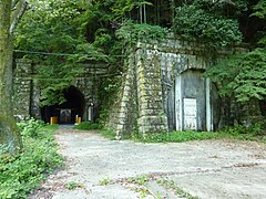
old Ōsakayama tunnel (replaced in 1921)

Freight train near Yamashina

Class 221 multiple unit in Yamashina station


.JPG)

Chronology of important events
- Aug. 18, 1879: opening of the Kyōto - Ōtani line; part of the line at that time corresponds to today's Nara line or the course of the Meishin motorway
- July 15, 1880: Opening of the Ōtani - Zeze - Ōtsu (now Biwako-Hamaōtsu ) line with the Ōsakayama tunnel
- May 1, 1882: Introduction of steamboat traffic on Lake Biwa between Ōtsu (today Biwako-Hamaōtsu) and Nagahama
- July 1, 1889: the Zeze - Maibara - Nagahama line opens ; Suspension of passenger traffic on the Zeze - Ōtsu branch line (today Biwako-Hamaōtsu); Discontinuation of steamship connection; Completion of the Tokyo - Kobe rail link
- April 1, 1895: Introduction of the route designation Tōkaidō Line (Tōkaidō-sen)
- 5th Mar 1897: second track between Kyoto and Ōtani
- April 15, 1898: second track between Ōtani and Zeze
- Aug 1, 1898: resumption of passenger traffic on the Zeze - Ōtsu branch line (today Biwako-Hamaōtsu)
- June 6, 1900: second track between Zeze and Kusatsu
- Nov. 28, 1901: second track between Notogawa and Yasu
- Dec. 1, 1901: second track between Notogawa and Kawase
- Dec. 5, 1901: second track between Maibara and Kawase
- June 16, 1902: second track between Kusatsu and Yasu
- Nov. 1, 1902: Introduction of the route designation Hokuriku Line (Hokuriku-honsen) for the Maibara - Nagahama section
- October 12, 1909: Introduction of the route name Tōkaidō Main Line (Tōkaidō-honsen)
- 1st Mar 1913: cessation of passenger traffic on the branch line Zeze - tsu (today Biwako-Hamaōtsu); new name Ōtsu-Linief
- Aug. 1, 1921: new double-lane route between Kyōto and Zeze through the Shin-Ōsakayama-Tunnel; Closure of the old route through the Ōsakayama tunnel
- 19 Sep 1956: electrification of the Maibara - Kyōto line; The entire Tōkaidō main line between Tokyo and Kobe can be driven continuously by electricity
- Aug. 12, 1957: second track between Nagahama and Tamura
- Oct. 1, 1957: second track between Tamura and Maibara; Electrification of the Nagahama - Tamura line; the missing section Tamura - Maibara is mastered with the help of a stationary steam engine
- December 28, 1962: Electrification of the Tamura - Maibara line
- Nov. 1, 1969: Closure of the Ōtsu line
- April 1, 1987: Privatization of the Japanese State Railways and transfer of the lines to the newly founded JR West
- 13 Mar 1988: Introduction of the brand name Biwako-Linie ( Biwako-sen ) for the Maibara - Kyōto section
- Sep 14 1991: Extension of the bivouac line to the Maibara - Nagahama section after the switch from AC voltage to DC voltage
List of train stations
Sk = Shin-kaisoku (Special Rapid)
| Surname | km | Sk | Connecting lines | location | place | prefecture | |
|---|---|---|---|---|---|---|---|
| Hokuriku main line | |||||||
| JR-A09 | Nagahama ( 山 科 ) | 7.7 | ● | Hokuriku main line | Coord. | Nagahama | Shiga |
| JR-A10 | Tamura ( 田村 ) | 4.7 | ● | Coord. | |||
| JR-A11 | Sakata ( 坂 田 ) | 2.4 | ● | Coord. | Maibara | ||
| Main Tōkaidō line | |||||||
| JR-A12 | Maibara ( 米 原 ) | 0.0 | ● |
Tōkaidō Shinkansen Tōkaidō main line (Toyohashi – Maibara) Ōmi main line |
Coord. | Maibara | Shiga |
| JR-A13 | Hikone ( 彦 根 ) | 6.0 | ● | Ōmi main line | Coord. | Hikone | |
| JR-A14 | Minami-Hikone ( 南 彦 根 ) | 9.3 | ǀ | Coord. | |||
| JR-A15 | Kawase ( 河 瀬 ) | 12.4 | ǀ | Coord. | |||
| JR-A16 | Inae ( 稲 枝 ) | 16.1 | ǀ | Coord. | |||
| JR-A17 | Notogawa ( 能 登川 ) | 19.8 | ● | Coord. | Higashiōmi | ||
| JR-A18 | Azuchi ( 安 土 ) | 24.9 | ǀ | Coord. | Ōmihachiman | ||
| JR-A19 | Ōmi-Hachiman ( 近 江 八 幡 ) | 28.4 | ● | Ōmi Yōkaichi line | Coord. | ||
| JR-A20 | Shinohara ( 篠 原 ) | 32.4 | ǀ | Coord. | |||
| JR-A21 | Yasu ( 野 洲 ) | 38.0 | ● | Coord. | Yasu | ||
| JR-A22 | Moriyama ( 守 山 ) | 41.1 | ● | Coord. | Moriyama | ||
| JR-A23 | Rittō ( 栗 東 ) | 43.2 | ǀ | Coord. | Rittō | ||
| JR-A24 | Kusatsu ( 草津 ) | 45.5 | ● | Kusatsu line | Coord. | Kusatsu | |
| JR-A25 | Minami-Kusatsu ( 南 草津 ) | 48.0 | ● | Coord. | |||
| JR-A26 | Seta ( 瀬 田 ) | 50.7 | ǀ | Coord. | Ōtsu | ||
| JR-A27 | Ishiyama ( 石山 ) | 53.2 | ● | Keihan Ishiyama-Sakamoto Lineage | Coord. | ||
| JR-A28 | Zeze ( 膳 所 ) | 56.0 | ǀ | Keihan Ishiyama-Sakamoto Lineage | Coord. | ||
| JR-A29 | Ōtsu ( 大 津 ) | 57.7 | ● | Coord. | |||
| JR-A30 | Yamashina ( 山 科 ) | 62.2 | ● |
Kosei Line Subway: Tōzai Line at Keihan Yamashina Station : Keihan Keishin Line |
Coord. | Yamashina , Kyoto | Kyoto |
| JR-A31 | Kyoto ( 京都 ) | 67.7 | ● |
Tōkaidō Shinkansen JR Kyoto Line Kosei Line Nara Line San'in Main Line ( Sagano Line ) Kintetsu Kyōto Line Metro: Karasuma Line |
Coord. | Shimogyō , Kyoto | |
Web links
- Information about the bivouac line on kyotostation.com (English)
- JR West route network (PDF, 1.0 MB)
Individual evidence
- ↑ 1960 年代 初 頭 湖 東線 臨 電 の 思 い 出. In: Tetsudōpikutoriaru , No. 736. Denkisha kenkyūkai, Chiyoda, 2003. pp. 38-39.
- ↑ JR 西 の 路線 、 愛称 開始 15 年. In: Asahi Shimbun , January 29, 2003.
- ↑ 昭和 63 年 2 月 定 例会 (第 1 号 〜 第 12 号). Shiga Prefectural Parliament, March 25, 1988, accessed July 31, 2018 (Japanese).
- ↑ 特集: 東海 道 本 線 (II). In: Tetsudōpikutoriaru , No. 873. Denkisha kenkyūkai, Chiyoda, 2013. pp. 20-29.
- ^ Dan Free: Early Japanese Railways 1853-1914: Engineering Triumphs That Transformed Meiji-era Japan . Turtle Publishing, Clarendon 2014, ISBN 978-4-8053-1290-2 , pp. 102-103 .
- ↑ a b JR 時刻表 2016 年 3 月 号 (JR timetable March 2016). Kōtsū shinbunsha, Tokyo 2016.
- ↑ 東海 道 本 線. In: Tetsudōpikutoriaru , No. 736. Denkisha kenkyūkai, Chiyoda, 2003. pp. 32-33.
Shinkansen: Hakata Minami Line | Hokuriku Shinkansen | San'yō Shinkansen
Current lines: Akō Line | Bantan line | Etsumi hoku line | Fukuchiyama Line | Fukuen Line | Gantoku line | Geibi line | Hanwa line | Hokuriku main line | Hakubi Line | Himi line | Honshi Bisan Line | Inbi line | Johana lineage | JR Miyajima Ferry | JR Tōzai Line | Kabe line | Kakogawa Line | Kansai Airport Line | Kansai Main Line ( Yamatoji Line ) | Katamachi line | Kibi line | Kisei main line | Kishin line | Kisuki line | Kosei line | Kure line | Kusatsu line | Maizuru line | Mine line | Nanao line | Nara line | Obama line | Ōito line | Onoda line | Osaka ring line | Osaka East Line | Sakai line | Sakurai line | Sakurajima line | San'in Main Line ( Sagano Line ) | San'yō Main Line ( Wadamisaki Line ) | Seto Ōhashi line | Takayama main line | Tōkaidō Main Line ( Biwako Line , JR Kobe Line , JR Kyōto Line ) | Tsuyama Line | Ube line | Uno line | Wakayama Line | Yamaguchi line
Released Lines: Miyazu Line | Nanao line | Noto line | Shigaraki line | Toyamakō Line | Wakasa line
Disused Lines: Kajiya Line | Sankō line | Taisha line