
Kobe
| Kobe-shi 神 戸 市 |
|||
|---|---|---|---|
 |
|||
| Geographical location in Japan | |||
|
|||
| Region : | Kinki | ||
| Prefecture : | Hyogo | ||
| Coordinates : | 34 ° 41 ' N , 135 ° 12' E | ||
| Basic data | |||
| Surface: | 552.23 km² | ||
| Residents : | 1,522,944 (October 1, 2019) |
||
| Population density : | 2758 inhabitants per km² | ||
| Community key : | 28100-0 | ||
| Symbols | |||
| Flag / coat of arms: |
 |
||
| Tree : | Camellia sasanqua | ||
| Flower : | Garden hydrangea | ||
| town hall | |||
| Address : |
Kobe City Hall 6 - 5 - 1 , Kana-machi Chūō-ku , Kobe -shi Hyōgo 650-8570 |
||
| Website URL: | www.city.kobe.lg.jp | ||
| Location of Kobe in Hyogo Prefecture | |||
 |
|||

Kobe ( Japanese 神 戸 市 , - shi ) is a city in Japan on the island of Honshū . The city is The capital of Hyogo and has one of the largest seaports in Japan. The modern, international city forms the heart of the Kansai area with Osaka and Kyōto ( Keihanshin ) and smaller cities . Kobe is one of the first designated cities from 1956.
geography

Geographical location
Kobe is located on the northern side of Osaka Bay ( see also Seto Inland Sea ). The urban area is divided by the Rokkō mountain ridge (height up to 931 m) into a densely populated band (approx. 40 km long and 2–7 km wide) directly on the coast and a more rural part in the north (districts Kita-ku and Nishi -ku ) shared with so-called New Towns ( satellite cities ). The city merges seamlessly into the neighboring cities of Akashi in the west and Ashiya in the east and is thus part of the large urban Kobe- Osaka - Kyoto conurbation. Because of the natural barrier on the land side of the city, like in the other cities bordering the bay, one began long ago to reclaim land from the sea by artificial embankments. Examples of this are the artificial islands of Port Island , Rokkō Island and the new Kobe Airport .
Several small rivers cross the urban area of Kobe on their way from the Rokkō to the sea. There are no larger natural freshwater areas, but some reservoirs can be found in the mountains. The largest of these is the Tsukuhara-ko in Nishi-ku district .
geology
Three continental plates ( Eurasian plate , Philippine plate and Pacific plate ) meet off the east coast of Japan . As in all of Japan, there are several seismically active faults in the Kobe area .
On May 22, 1925, several violent tremors shook the region. The center of the quake, however, was in the fishing village of Toyo-oka, which was completely destroyed and killed around 5000 people. After about 600 years of relative calm in the central area of Kinki, an earthquake with a magnitude of 7.2 on the Richter scale (M j 7.3 on the new JMA magnitude scale ) occurred on January 17, 1995 at 5:46 a.m. local time . This caused shocks with a maximum intensity of 7 on the JMA scale, which is widely used in Japan . The epicenter was close to the city in the Akashi Strait, so that the distance between the pillars of the Akashi Kaikyō Bridge, which was then under construction , was increased by almost one meter as a result of the quake. As a result of the quake, 6,433 people died, 43,792 were injured and 300,000 were left homeless. Large areas of the city were destroyed. The damage was the largest so far in an earthquake (estimated at around € 100 billion), and the Hanshin Autobahn , a motorway that was considered earthquake-proof at the time , also collapsed. Because the quake affected the Hanshin region in addition to the city of Kobe, it is also called the great Hanshin earthquake (or the Hanshin Awaji earthquake).
City structure
Kobe is divided into 9 districts :

|
Code with check digit |
Surname | Area (in km²) | population | Population density (inh / km²) |
||
|---|---|---|---|---|---|---|
| Rōmaji | Kanji | 01.10.2017 1 | 01.10.2018 2 | 01/10/2015 3 | ||
| 28101-8 | Higashinada-ku | 東灘 区 | 34.02 | 213,944 | 213,634 | 6279.66 |
| 28102-6 | Nada-ku | 灘区 | 32.66 | 136.985 | 136.088 | 4166.81 |
| 28105-1 | Hyogo-ku | 兵 庫区 | 14.68 | 107.191 | 106,956 | 7285.83 |
| 28106-9 | Nagata-ku | 長 田 区 | 11.36 | 95,721 | 97.912 | 8619.01 |
| 28107-7 | Suma-ku | 須 磨 区 | 28.93 | 159.127 | 162,468 | 5615.90 |
| 28108-5 | Tarumi-ku | 垂 水 区 | 28.11 | 217,389 | 219.474 | 7807.68 |
| 28109-3 | Kita-ku | 北区 | 240.29 | 214.037 | 219,805 | 914.75 |
| 28110-7 | Chūō-ku | 中央 区 | 28.97 | 140,897 | 135,153 | 4665.27 |
| 28111-5 | Nishi-ku | 西区 | 138.01 | 242.116 | 245,782 | 1780.90 |
| 28100-1 | Kobe-shi | 神 戸 市 | 557.02 | 1,527,407 | 1,537,272 | 2759.81 |
The central district ( Chūō-ku ) was formed on December 1, 1980 from the two (dissolved) districts Fukiaki-ku (1980: 63,516 Ew.) And Ikuta-ku (51,813 Ew.). The northern municipality ( Nishi-ku ) was split off from the Tarumi-ku municipality on August 1, 1982 .
1 Area data from 2017
2 Estimated population 2018
3 Results of the 2015 census
climate

Kobe is located in the subtropical climate zone with a fully humid climate. The average annual temperature is around 16 degrees Celsius. The warmest months are July and August with an average temperature of around 27 degrees Celsius. The coldest months are January and February with an average of five degrees Celsius.
The mean annual amount of precipitation is around 1,316 millimeters. Most of the precipitation falls in the rainy season in June (an average of 218 mm) and September (an average of 170 mm), while the least is in December with an average of only 38 millimeters. In September the typhoon season begins, which is responsible for the heavy precipitation in late summer.
The relatively high humidity (68 percent on average) is quite a problem, especially in summer. From June to September the average relative humidity is between 70 and 80 percent.
history
It is believed that the name Kobe is derived from the same spelled Kambe . Kambe were specific families who had to pay all of their taxes to a specific shrine - here the Ikuta Shrine . This Kambe settlement Kambe-mura is said to have been pronounced as Kobe-mura over time.
The port of Kobe developed early due to its good location. In the Nara period (710–784 AD) merchant ships from China and other countries moored at Owada no Tomari . Ever since the capital was moved from Heian-kyō to Fukuhara-kyō in today's Hyōgo-ku for a short time , military conflicts (especially between the Heike and Genji ) have been fought here. B. the battle of Ichi-no-Tani in 1184.
Later the port developed into one of the most important in Japan. It is said that the famous unifier Toyotomi Hideyoshi often came here to visit the hot springs of Arima Onsen.
In the Edo period (1603–1867), today's Nada-ku district was known for its sake breweries. Even today, most of Japanese sake production comes from there.


When Japan opened up to the world under pressure from America in the Meiji Restoration , in 1868 the go-ahead was given for the development of Kobe into an international port city. Many Americans and Europeans came to Kobe and established themselves in what is now Kyū kyoryū-chi (former foreign settlement) near the port and in Kitano . Because of the many traders, western goods and western culture came to Japan. Kobe is considered to be the birthplace of cinema and jazz in Japan. In 1899 the extra-territorial rights of the European colonial powers from the unequal treaties and the foreigners' quarter as such were abolished.
Today (2005) around 44,500 foreigners from more than 115 nations live in Kobe, that is almost 3% of the population (more than 50% of them Koreans).
When the prefectures were set up in the Meiji Restoration, the later city became the seat of the prefectural administration of Hyōgo in 1868, which expanded to five provinces during the consolidation of the prefectures in the following years. During the reactivation and reorganization of the districts in Hyōgo, the port of Hyōgo ( 兵 庫 津 ), the city of Kobe ( 神 戸 町 ) and the village of Sakamoto ( 坂 本村 ) from the district of Yatabe (later Muko ) became the urban district of Kobe ( 神 戸 区 , Kobe - ku ) merged. From this and two other villages, today's independent city of Kobe (Kobe-shi) emerged on April 1, 1889 with the introduction of modern Japanese municipal services . In 1922 Kobe became one of the "six major cities" , in 1956 a major city by government decree with expanded self-government. In 1931 the then urban area was divided into eight administrative districts, after many incorporations (1941, 1947, 1950, 1951, 1955, 1958) and several reorganizations (1945, 1946, 1973, 1980, 1982) there are nine districts since 1982.
The University of Kobe was founded in 1902.
During the Second World War , the city was bombed several times with napalm bombs by the United States Army Air Forces (USAAF) between February 1945 and August 1945 . The attacks destroyed around 57% of the city area and left almost 6,300 dead and 15,800 injured. The attacks were from 18.6 to 22.8 km 2 of the city burned and 452,059 people were left homeless. (see air raids on Kobe )
After the great Hanshin earthquake in 1995, many buildings had to be rebuilt, which meant that Kobe is now a modern sight in most parts of the city. The port, which until the earthquake was the largest in Asia and the second largest in the world, lost its rank to Nagoya , as many companies had to move to other ports due to the earthquake and only partially returned.
politics
(as of November 1, 2019)
The former Vice Mayor Kizō Hisamoto has been Mayor of Kobe since 2013 . In 2017, when the mayoral election coincided with the national lower house election , he was re-elected for a second term with the support of LDP , Kōmeitō and Minshintō by a large majority against two challengers from Ishin no Kai and KPJ .
The city council ( Kobe-shikai ) has 69 regular members who are elected in the city districts by non-transferable individual votes. In the last election in April 2019 , the Liberal Democratic Party (LDP) remained the strongest party with 20 seats, the Kōmeitō won an unchanged twelve seats, the Ishin no Kai ten (+4), the CPJ only nine and the KDP seven, the DVP two ; the New Socialist Party held its two MPs, seven seats went to independents and the local party 神 戸 志 民 党 Kobe shimintō (about "citizens' party", however shimin / "citizen" is not normal with 市 shi , "city", but with 志 shi) , ~ "Will, readiness, intention", written).
In the 86-member prefectural parliament of Hyōgo, the boroughs of Kobe elect a total of 23 members as two- or three-mandate constituencies.
For the national lower house, Kobe is in the constituencies of Hyōgo 1 to 4; The latter is largely outside the city, the other three entirely in Kobe. In the 2017 general election, the constituencies Hyōgo 1, 3 and 4 went to Liberal Democrats, and constituency 2 went to the Kōmeitō.
City symbol

The city symbol of Kobe - two intersecting semicircles - symbolize the fan-like shape of the two ports Kobe and Hyogo. The symbol is also derived from the Japanese character カ ( katakana ), which appeared in the previous name カ ウ ベ . It was introduced in 1907 and is now visible in many places.
Town twinning
-
 Seattle , USA - since 1957
-
 Marseille , France - since 1961
-
 Rio de Janeiro , Brazil - since 1969
-
 Tianjin , China - since 1973
-
 Riga , Latvia - since 1974
-
 Brisbane , Australia - since 1985
-
Philadelphia , USA - since 1986
-
 Barcelona , Spain - since 1993
Culture and sights


Although Kobe is not a typical tourist town, there is a lot to see. The Kobe City Museum owns u. a. an important collection of Western art from the time of the Christian missionary trade around 1600. Kobe is known for the Arima Onsen , its former foreign settlements ( 旧 居留地 , kyū kyoryūchi ), Kitano and the Chinatown Nankin-machi (dt. " Nanking district “), The sake district in Nada and the port area with its attractions. Furthermore, the Rokkō Mountains with a height of almost 1000 meters offer a variety of hiking opportunities with spectacular views of the entire region. In the port area of Hyōgo you will find the Kobe Daibutsu (large Buddha statue) and the historical hiking trail "Street of the Hyōgo Port" ( Hyōgo-tsu no Michi ). Further west in Suma there are sandy beaches and the famous Akashi Kaikyō Bridge .
Museums
- DRI - Museum of Natural Disasters ( こ の ペ ー ジ を 訳 す )
- Center for Ground Monuments Kobe ( 神 戸 市 埋 蔵 文化 財 セ ン タ ー )
- Hashi no Kagakukan ("Bridge Museum")
- Foreigners Club in Kitano ( 北野 外国人 倶 楽 部 )
- Science museum with planetarium Kobe
- Kobe Water Science Museum ( 神 戸 市 水 の 科学 博物館 )
- Kobe Lamp Museum
- Kobe Doll Museum
- Aquarium Kobe in Suma
- Kitano Art Museum ( 神 戸 北野 美術館 )
- Kosetsu Art Museum
- Hakutsuru Art Museum
- Maritime Museum in Meriken Park ( 神 戸 海洋 博物館 )
- Moegi no Yakata ( 萌 黄 の 館 )
- Hakutsuru Sake Brewery Museum ( 白鶴 酒 造 資料 館 )
- Kobe Municipal Museum
- Takenaka Carpentry Tool Museum
- UCC Coffee Museum ( UCC コ ー ヒ ー 博物館 ) on Port Island
music
Kobe is known for its jazz clubs.
Buildings
- The port area is dominated by the Kobe Port Tower . The interesting structure is a 108 meter high steel lattice tower in the form of a hyperboloid with a viewing platform at a height of 90.28 meters. The port tower was opened in 1963
- Also in Meriken Park, right next to the Port Tower, is the Maritime Museum with its unusual roof structure
- The Meriken Park Oriental Hotel in the harbor is striking because of its unusual shape. It looks like a huge ship, which is emphasized by the fact that it is surrounded by water on 3 sides
- The 158 meter high Oriental Hotel in Shin-Kobe is the tallest building in Kobe with its 35 floors
- The Akashi Kaikyō Bridge in the Suma district connects Kobe with Awaji Island . Measured by the freely spanned width, it is the largest suspension bridge in the world and offers a variety of illuminations at night.

Kobe Port Tower
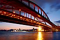
Kobe-Ohashi

Kobe Maritime Museum

Meriken Park Oriental Hotel

Meriken park


Temples and shrines

- Ikuta Shrine in Sannomiya
- Minatogawa Shrine near JR Kobe Train Station
- Nagata Shrine in Nagata
- Suwayama Shrine on Mount Suwa
- Sumadera Temple in Suma
- Kanteibyō (Chinese Temple)
Other religious sites
- Japan's first mosque , the Kobe Mosque , was built in Kitano in 1935
- A synagogue can also be found in Kitano since 1937
- There are several Christian churches, for example the Kobe Union Church, the Cathedral Church of St. Michael or the St. Andrews Church.
- Foreigner Cemetery ( 外国人 墓地 ), nice but secluded on the slope of the Futatabiyama. Only accessible to "grieving relatives."

Kanteibyō

The mosque of Kobe

Chapel in the foreigners cemetery

Hermann Bohner's grave
.jpg)


Thermal baths (onsen)

- Arima Onsen (Kita-ku)
- Tennō Onsen (Hyogo-ku)
- Minatoyama Onsen (Hyogo-ku)
- Suma Onsen (Suma-ku)
- Nadeshiko no Yu (Nishi-ku)
- Kanoko Onsen (Kita-ku)
- Gosha Onsen (Kita-ku)
- Shiawase no Mura (Kita-ku)
- Ozo Onsen (Fruit & Flower Park, Kita-ku)
Parks

- Fruit & Flower Park
- Nunobiki Herb Park
- Sorakuen
- Suma Rikyu Park
- Kobe Earthquake Memorial Park
- Meriken Park
Sports


Stages:
- Noevir Stadium
- Kobe Sports Park with Green Arena, Skymark Stadium (formerly "Green Stadium", also known as YahooBB Stadium) and Universiade Memorial Stadium
- Port Island Sports Center (ice rink)
Teams:
- Baseball : Orix Buffaloes - Pacific League
- Baseball : Hanshin Tigers - Central League
- Soccer: Vissel Kobe - J. League
- Rugby: Kobe Steel Kobelco Steelers
- Ice hockey: Nikko Kobe IceBucks - Asia League Ice Hockey (together with Nikko)
Regular events

- Every year in December , the Kobe Luminarie takes place in Higashi Yuenchi Park in Sannomiya in memory of the great Hanshin earthquake . The Luminarie originally comes from Italy and is a festival of lights with particularly decorative illuminations.
- In April, the Infiorata , which also goes back to an Italian custom, takes place in different parts of Kobe. Whole streets are covered with carpets of flowers in which pictures are displayed
- The great Kobe Matsuri in May is a festival across the city. The Samba Festival that takes place in this context is very popular.
- In Nankin-machi, the Chinatown of Kobe, the Chinese New Year is celebrated from mid-January to early February and the Mid- Autumn Festival in mid-September
- Kobe Jazz Street in October in Kitano
Culinary specialties
Kobe is famous for its special breeding cattle , the beef obtained from it and the sake (rice wine) from Nada. Furthermore, wine is grown in the rural parts (Nishi-ku and Kita-ku). Various sweets (especially pudding ) and pastries also come from Kobe. Another regional specialty are ikanago no kugini ( い か な ご の く ぎ 煮 ), small baby fish that are cooked with soy sauce , ginger , mirin and sugar and usually eaten over rice.
Economy and Infrastructure

70% of the companies in Kobe are in the tertiary sector (service sector), 30% in the secondary sector (manufacturing industries) and less than 1% in the primary sector (primary production). Measured by value, the important port handled 8% of all Japanese foreign trade in 1998, making it the third most important port after the ports of Yokohama and Tokyo (each 11%). Thanks to the port, heavy industry such as B. Kawasaki Heavy Industries and Mitsubishi Heavy Industries with large industrial plants and shipyards (submarine construction) are located. Important industrial products are ships, railroad trains, iron and steel, motorcycles, rubber, shoes (around 60% of Japanese production up to the 1995 earthquake), machines; typical goods are sake , wine, pastries and sweets ( see Karl Joseph Wilhelm Juchheim ) and the exquisite kobe beef . Kobe has a prominent position in the pearl trade.
traffic
Local transport
Sannomiya Station is Kobe's interchange. All local trains and almost all long-distance trains except the Shinkansen stop here .
The "inner city" of Kobe is located between the JR Kobe and Sannomiya train stations . So if you want to go to the center, it is best to get off in Motomachi or Sannomiya. Due to the topography, the routes of the three railway companies Japan Railway (JR), Hanshin and Hankyū between Kobe and Ōsaka are similar: They meet in Sannomiya and Umeda and compete with each other on travel time and price (see train accident in Amagasaki ).
The subway network was opened in 1977. It currently consists of two lines (see Kobe Metro ).
A fully automated people mover (port liner) connects Sannomiya with the artificial island of Port Island and with the new airport of Kobe . Rokkō Island is accessible via a second people mover (Rokkō Liner) that connects the island to JR Sumiyoshi Station and Hanshin Uozaki Station.
About the Akashi Kaikyō Bridge , the island of Awaji and Shikoku by car and bus. Of Akashi from there is also a ferry service to the island of Awaji.
Long-distance transport
Railway: Like all cities in Japan, Kobe has excellent transport connections. Due to the new route under the entire Rokkō massif , the Shinkansen station Shin-Kobe was built about 1 km from the Sannomiya station and can be reached on foot and by subway . The journey times with the fastest Nozomi -Shinkansen are: to Tokyo 2:50, Fukuoka 2:20, Hiroshima 1:15, Nagoya 1:08 and to Kyoto 0:30.
Air traffic: On February 16, 2006, the controversial new construction of Kobe Airport on an artificial island south of Kobe went into operation, although even the neighboring Kansai Airport did not solve its occupancy problems in the 10th year. Kansai International can be reached from Sannomiya by airport bus in around 70 minutes and by train in around 90 minutes. From Kobe Airport, you can take a high-speed ferry to Kansai Airport in 30 minutes.
Shipping: There are shipping connections to Shikoku , Kyushu , Okinawa as well as Shanghai and Tianjin in the People's Republic of China .
Bus traffic: There are regular buses from Sannomiya to Tokyo , Kyūshū and Shikoku .
education
There are 17 universities and 8 other colleges in Kobe. In addition, 83 technical schools, 61 high schools, 104 middle schools, 175 elementary schools, 10 schools for the disabled and 156 crèches. Due to the relatively high number of foreigners, there are also 9 international schools here (as of 2004).
Public Universities
- Kobe University , founded in 1902, approx. 16,000 students, one of the oldest and largest state universities in Japan
- Hyogo Prefectural University , founded in 2004, emerged from the merger of the Kobe University of Commerce , the Himeji Institute of Technology , and the College of Nursing Art and Science, Hyogo
- Kobe City University of Foreign Studies, founded in 1946, approximately 2,000 students
- Kobe City College of Nursing, founded in 1995, approx. 400 students
Private universities
- Konan University
- Konan Women's University
- Kobe Kaisei College (Women's University)
- Gakuin University Kobe
- Design University of Kobe
- Kobe International University
- Kobe Shoin Women's University
- Kobe Women's University
- Shinwa Women's University Kobe
- Pharmaceutical University of Kobe
- Yamate University Kobe
- University of Marketing and Distribution Science
International schools
- Marist Brothers International School (Montessori-12), in Suma-ku , founded in 1951
- Canadian Academy (K-12), on Rokkō Island , founded in 1913
- St. Michael's International School, a small British primary school in Sannomiya, founded in 1946
- German School Kobe - European School, in Nada-ku , founded in 1909, English branch since 2001
- Mikage International Preschool in Higashinada-ku and Ashiya International School in Ashiya , founded in 1963
- Ecole Francaise du Kansai, in Higashinada-ku (Mikage Elementary School)
- Norwegian school, in Higashinada-ku
- Kobe Zhonghua Tongwen School (China), in Chūō-ku
- Hyōgo Chōsen Gakuen (Korea), in Chūō-ku
Personalities
literature
- Otto Refardt: The Germans in Kobe since 1868. Memories of old Kobe. Lecture given to the Kobe-Osaka Branch, December 1954 . In: Communications of the German Society for Nature and Ethnology of East Asia , Vol. 39, Part A, 1956, pp. 17–36.
Web links
- City website
- Kobe City Info (English) ( Memento of 18 December 2010 at the Internet Archive )
Individual evidence
- ↑ The smiling death. Earthquake in Kobe. In: Vossische Zeitung , June 25, 1925, morning edition, p. 5.
- ↑ Kokudo Chiriin (GSI - Geospatial Information Authority of Japan), 平 成 29 年 全国 都 道 府 県 市区 町 村 別 面積 調 (Nationwide survey of all prefectures and municipalities 2017) , p. 69: 28 Hyogo-ken ( Memento of the original from 2. January 2019 in the Internet Archive ) Info: The archive link was inserted automatically and has not yet been checked. Please check the original and archive link according to the instructions and then remove this notice. (Japanese). Retrieved January 1, 2019.
- ↑ 簡 単 検 索 ・ 詳細 検 索 ・ 検 索 サ ン プ ル , accessed January 1, 2019. (Japanese)
- ↑ e-stat (English), accessed on January 1, 2019.
- ^ Otto Refardt: The Germans in Kobe (Old Kobe). In: Communications of the German Society for Nature and Ethnology of East Asia. Volume 39, Part A, 1956, p. 18.
- ↑ City Archives Kobe ( 神 戸 市 文書 館 , Kobe-shi monjokan ): Timeline of history, Meiji / Taishō , since Shōwa (Japanese)
- ↑ Kobe City Council: Members by parliamentary group (Japanese), accessed December 10, 2019.
- ↑ 神 戸 市長 選 久 元氏 が 大 差 で 再 選 . In: Kobe Shimbun . October 23, 2017. Retrieved June 10, 2018 (Japanese).
- ^ City of Kobe: City Council (Japanese).
- ↑ 神 戸 市 議 選 各 党 議席 . In: NHK Senkyo Web. April 8, 2019, Retrieved December 10, 2019 (Japanese).
- ↑ 議員 紹 介> 選 挙 区別 一 覧 表 (German: "Presentation of the MPs> Overview by constituency"). 兵 庫 県 議会 ("Hyōgo Prefectural Parliament"), August 27, 2019, accessed on December 10, 2019 (Japanese).
- ↑ Jap. Website for the historical hiking trail with maps, descriptions, etc.
Independent cities ( shi ): Aioi | Akashi | Akō | Amagasaki | Asago | Ashiya | Awaji | Himeji | Itami | Kakogawa | Kasai | Katō | Kawanishi | Kobe (administrative headquarters) | Miki | Minamiawaji | Nishinomiya | Nishiwaki | Ono | Sanda | Shisō | Sumoto | Takarazuka | Takasago | Tamba | Tambasasayama | Tatsuno | Toyooka | Yabu
Akō-gun : Kamigōri | Ibo-gun : Taishi | Kako-gun : Harima | Inami | Kanzaki-gun : Fukusaki | Ichikawa | Kamikawa | Kawabe-gun : Inagawa | Mikata-gun : Kami | Shin'onsen | Sayō-gun : Sayō | Taka-gun : Taka